Showing 40540 items matching "roads and streets"
-
 Canterbury History Group
Photograph - Street view of shop No. 84 Maling Road Canterbury in The Block 1907, Stuart Warmington, 1995
Coloured photograph of street view of shop No. 84 Maling Road Canterbury in The Block 1907canterbury, maling road, the block 1907 -
Canterbury History Group
Photograph - Street view of 2 shops in Maling Road Canterbury in The Block 1907, Stuart Warmington, 1995
Coloured photograph of street view of 2 shops in Maling Road Canterbury in The Block 1907canterbury, maling road, shops, the block 1907 -
Canterbury History Group
Photograph - Street view of shop No. 82 in Maling Road Canterbury in The Block 1907, Stuart Warmington, 1995
Coloured photograph of street view of shop No. 82 in Maling Road Canterbury in The Block 1907canterbury, maling road, shops, the block 1907 -
Canterbury History Group
Photograph - Street view of 2 shops in Maling Road Canterbury in The Block 1907, Stuart Warmington, 1995
Coloured photograph of street view of 2 shops in Maling Road Canterbury in The Block 1907canterbury, maling road, shops, the block 1907 -
Canterbury History Group
Photograph - Street view of shop No. 82 in Maling Road Canterbury in The Block 1907, Stuart Warmington, 1995
Coloured photograph of street view of shop No. 82 in Maling Road Canterbury in The Block 1907canterbury, maling road, shops -
Canterbury History Group
Photograph - Street view of shop No. 86 Maling Road, Canterbury in The Block 1907, Stuart Warmington, 1995
Coloured photograph of street view of shop No. 86 Maling Road, Canterbury in The Block 1907canterbury, maling road, shops, the block 1907 -
Canterbury History Group
Photograph - Street view of shop No. 80 Maling Road, Canterbury in The Block 1907, Stuart Warmington, 1995
Coloured photograph of street view of shop No. 80 Maling Road, Canterbury in The Block 1907canterbury, maling road, shops, the block 1907 -
Canterbury History Group
Photograph - Street view of double shop No. 76-78 in Maling Road , Canterbury, Stuart Warmington, 1995
Coloured photograph of street view of double shop No. 76-78 in Maling Road , Canterburycanterbury, maling road, shops -
 Tarnagulla History Archive
Photograph, Commercial Road, Tarnagulla, early 1990s
Donald Clark Collection. A colour photograph depicting Commercial Road, near King Street in Tarnagulla. Original photograph. -
Canterbury History Group
Photograph - Canterbury Theatre, c1960s
Photocopy of a photograph of the Canterbury Theatre taken at the corner of Bryson Street and Maling Road Canterburycanterbury, canterbury hall, theatres, maling road, newsagents, theatre place -
Canterbury History Group
Photograph - Streetscape outside shop No. 84 and No. 82 Maling Road, Jan Pigot, 27/03/1993 12:00:00 AM
Coloured photograph of the streetscape outside 2 shops in Maling Road depicting street plantingcanterbury, maling road, shops, streetscapes, street tree plantings -
Canterbury History Group
Photograph - Streetscape of the shop No. 103 Maling Road, Jan Pigot, 27/03/1993 12:00:00 AM
Coloured photograph of the street view of Time For Tea gift shop at No. 103 Maling Roadcanterbury, maling road, shops, streetscapes, signs -
Canterbury History Group
Photograph - Street sign of Theatre Place at Theatre Place, Maling Road Canterbury, Jan Pigot, 1994
Coloured photograph of street sign of Theatre Place at Theatre Place, Maling Road Canterburycanterbury, maling road, shops, signs -
Canterbury History Group
Photograph - Street view of shop at No. 98 Maling Road, Jan Pigot, 1994
Coloured photograph of the street view of the shop called Status Travel at No. 98 Maling Roadcanterbury, maling road, shops -
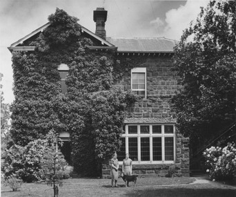 Kew Historical Society Inc
Photograph - Alma and Silvia Figuerola, D'Estaville, The Age, c.1965
The Melbourne artist Alma Agnes Marion Figuerola, was the daughter of Juan Pedro Narciso Figuerola (1869-1919) and Alice Lucinda Walker Hanson (1889-1969). Each of their three daughters grew up to be involved in the arts: Alma as a painter; Carmen Irene (1906-1993) as a short story writer, poet and teacher of dancing; and Sylvia (also Silvia) Lyla Alice (1911-1992) as a composer and cellist. The first art lessons Alma Figuerola received were with Oscar Binder. Later she attended the art school established by the Melbourne 'tonalist' [Duncan] Max Meldrum (1875-1955). She graduated from his school in 1920, participating in her first group exhibition in the same year. Solo exhibitions of her work were to be held in 1933 at the Meldrum Gallery in Elizabeth Street, in 1937 and 1945 at the Athenaeum Gallery at 188 Collins Street, and in 1951 at Georges Gallery in Collins Street. Throughout her extensive career she participated in group exhibitions, usually with artists of the Meldrum School, and as a member of the Twenty Melbourne Painters, of which she was invited to become an associate in 1935. In 1953, her portrait of Professor ES Hills was entered in the Archibald Prize Competition of the Art Gallery of New South Wales. A resident of Kew from the 1930s - 51 Studley Park Road, often with her mother, her sister Carmen, or both - from c.1942 until her death she lived at 'D’Estaville', 7 Barry Street. From the late 1930s she is recorded as actively contributing to the arts at a local level. In 1939 and 1940 she participated in art exhibitions at the Hawthorn Municipal Library organised by Jessie Carbines. From 1944 to 1951 she co-organised successive Kew Arts Festivals, initially in the Presbyterian Church Hall in Highbury Grove and later at the Recreation Hall in Wellington Street. A foundation member of the Kew Historical Society in 1958, Alma Figuerola remained an active member of the Society until her death on 8 December 1970. She predeceased her two sisters who both died in the 1990s and who are buried at Andersons' Creek Cemetery in Warrandyte.This photographic is part of a series that is historically and aesthetically significant, in that they record the appearance of an historic Kew mansion in the 1960s, and also its owner, Alma Figuerola, a pupil of Max Meldrum, and a Melbourne artist who lived in Kew.D'Estaville, Barry Street, Kew. The facade facing Barry Street. The original front of the property faced Studley Park Road where the front door is still located. This is a newspaper photograph, part of a series on the artist Alma Figuerola, and is still under copyright. Alma Figuerola was a foundation member of the Kew Historical Society. She died in 1970, so the photograph predates this. Annotation on reverse: "View showing side of mansion there is a wing running from left hand side. / Owner with her sister Silvia and "the Head".alice figuerola, australian artists, d'estaville, 7 barry street -- kew (vic.) -
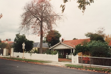
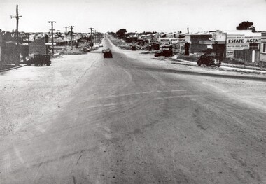 City of Kingston
Photograph - Black and white, 1950
... Roads ...This photograph depicts the increasing urbanisation of a once rural area at Moorabbin.This image is one of many in the collections that focuses on either roads or the railway. The development of roads and the railway was crucial to the ongoing development of the area. Black and white photograph of South Road, Moorabbin, with Station Street to the right and Jasper Road further down to the left. Along both sides of the road are retail spaces which become homes on the left hand side, after Jasper Road.Handwritten in red ink on reverse: 80% Handwritten in blue ink on reverse: 216moorabbin, roads, cars, shopping strip, housing -
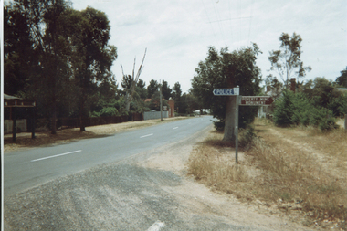
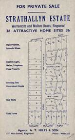 Ringwood and District Historical Society
Flyer, Land Sale Advertisement - Strathallyn Estate, Ringwood, Victoria - circa 1950
Advertisement for private sale of 36 home sites in the Warrandyte Road and Mullum Mullum Road area of Ringwood, with map showing layout of subdivision and summary of local features and services. Handwritten notation indicates May, 1950.Subdivision includes Warrandyte Road, Strathallyn Road, Norman Court, Lade Court, and Mullum Mullum Road. Agents: A.T. Miles & Son, 175 Main Street, Ringwood, Phone WU6215. -
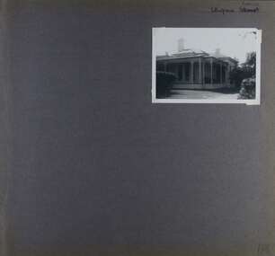 Glen Eira Historical Society
Album - Album page, Ulupna Road, Circa 1972
This album was created in approximately 1972 as part of a project by the Caulfield Historical Society to assist in identifying buildings worthy of preservation. The album is related to a Survey the Caulfield Historical Society developed in collaboration with the National Trust of Australia (Victoria) and Caulfield City Council to identify historic buildings within the City of Caulfield that warranted the protection of a National Trust Classification. Principal photographer thought to be Trevor Hart, member of Caulfield Historical Society. Most photographs were taken between 1966-1972 with a small number of photographs being older and from unknown sources. All photographs are black and white except where stated, with 386 photographs over 198 pages. Page 196 of Photograph Album with one photograph of a Victorian house on Ulupna RoadHandwritten: Ulupna Street (crossed out) Road [ top right] / 196 [bottom right]trevor hart, chimneys, porch, garden, single storey, return verandah, ulupna road, ormond, decorative brackets, cast iron frieze, cast iron columns, full length windows, villa residence, cast iron work, victorian period -
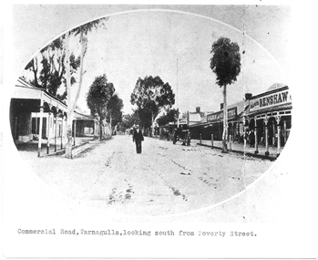 Tarnagulla History Archive
Photograph of Commercial Road, Tarnagulla looking south from Poverty Street, Commercial Road, Tarnagulla Looking South from Poverty Street, January 1907, at the time of the Poseidon Gold Rush, circa 1890 - 1900
Murray Comrie Collection. This is a reasonable copy of an older original. Copy probably made by Murray Comrie in the 1970s. Monochrome photograph. View of Commercial Road Tarnagulla looking south. A man at centre, walking toward camera. Right of this figure are two carts standing at the road's edge. Far right is Renshaw's Drapery and left of that the Golden Age Hotel. A man is walking along the footpath in front of Renshaw's. Typed caption on original is 'Commercial Road, Tarnagulla, looking south from Poverty Street'.tarnagulla, commerce, stores, shopping, shops, draper, hotels, golden age hotel, buildings, commercial road, main street -
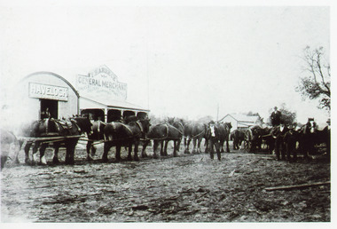 Lakes Entrance Historical Society
Photograph - Harbeck's Store, 1900c
Second black and white copySepia photograph of Harbecks Store, Esplanade, showing a team of horses, also wagon and horses in front of the store. Five men with horses, one man in doorway of feed store. Lakes Entrance VictoriaCunninhame, corner of Esplanade and Carpenter Street, 1890c - Tambo Shire collection, Country Roads.township, retail trade, transport, animals -
 Ringwood and District Historical Society
Plan, Ringwood Station Estate, Subdivision, Ringwood, Victoria - circa 1925
ID 5224 note: Further information relating to squares marked H, F, G, J, and K included in ID 5225 - Ringwood Shop and Dwelling Estate.Hand drawn plan of Ringwood Station Estate showing allotments for sale, with two typed pages attached showing land title information and sale prices.Drawn by Edyth Greenwood, phone 988 Central. Subdivision includes Station Street, Pitt Street, Bedford Road, Wantirna Road, James Street, William Street (later Kendall Street), Greenwood Avenue, Ellison Street, and Haig Street. Circles denote blocks for sale. Squares denote house properties for sale. Other features marked include location of businesses along Main Street (Maroondah Highway), cool store, railway station, shop and police station on Bedford Road, church on Station Street, site of schoolmaster's residence and State School, and location of proposed public baths. Ryner & Langford, Solicitors -
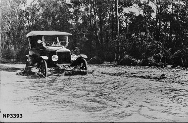 Whitehorse Historical Society Inc.
Photograph, Blackburn Road at Heath Street, Blackburn
Large black and white photograph of Blackburn Road near Heath Street. A car driving through water with street behind Photo hanging in Museumblackburn road, blackburn, heath street -
 Kew Historical Society Inc
Photograph - Carson Street, Kew, 1993
A series of five photographs of streetscapes in Kew in 1993, of which this is one, focus on footpaths and gutters, so while the provenance is uncertain, it is presumed that they were created in the office of City Engineer in the City of Kew.Colour positive print of Carson Street in Kew, dating from 1993. Carson Street runs between Studley Park Road and Findon Crescent.carson street -- kew (vic.) -
Canterbury History Group
Photograph - Bryson Street view of the back of shop No. 92 Maling Road, Jan Pigot, 1994
Coloured photograph of the Bryson Street view of the back of Road and Bryson Street depicting Buckley's Supermarket. This is also the corner of the building named The Block 1907.canterbury, maling road, shops, the block, bryson street, buckley family -
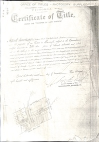 Whitehorse Historical Society Inc.
Document - Land Title, Certificate of Title, 29/11/1887
Photocopies of land titles involved in subdivision of land on the north-west corner of Whitehorse Road and Mitcham Road including Britannia Street. A list of purchasers is included.mitcham road, mitcham, whitehorse road, britannia street, rawlings, alfred, frost, john, richards, thomas, leech, george arthur, smith, reed, richard louis, young, frederick, hughes, doery, george henry, mitcham primary school, no. 2904, land subdivision -
Canterbury History Group
Photograph - Street view of the Bryson Road side of shop No. 92 Maling Road, Jan Pigot, 1994
Coloured photograph of the street view of the Bryson Road side of Buckley's Supermarket, shop No. 92 Maling Road. This is also the corner of the building named The Block 1907.canterbury, maling road, shops, bryson street, buckley family, the block -
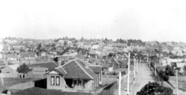 Surrey Hills Historical Society Collection
Photograph, Surrey Hills viewed from 'Quamby' at 293 Mont Albert Road, c 1915, 1915
Quamby was built in 1898. From 1900/1903-1924 it was the home of Andrew Sherar and family. From 1924-1960s it operated as Mosgiel Hospital under the direction of Matron Elizabeth Anderson. Until Box Hill Hospital opened most Surrey Hills children were born at Mosgiel or at Nethercourt Hospital in Wilson Street or later in Union Road when Matron Tank moved her hospital here. Mosgiel Hospital was demolished c 1975 after it was sold by Box Hill Hospital. It was replaced by units. Andrew Sherar was conductor of the Wyclif Church choir for many years and was a member of the Melbourne Liedertafel. Isie Sherar was organist at Wyclif Church and also taught piano in Union Road. Connie Sherar was in the Wyclif choir and married Ernest Swan, an elocutionist and orator. Dorothy Sherar was a pianist and accompanist. Elsie Sherar was also in the Wyclif choir and was a soloist; she later moved to Templestowe. Ken Sherar was a boy soprano at St Paul's Cathedral; he later moved to Queensland.Black and white photo looking south down Vincent Street from 'Quamby', located at 293 Mont Albert Road, Surrey Hills. In the centre foreground is a timber house with 2 chimneys and a tiled hip roof. It has a return veranda and is fenced on 2 sides by paling fences and picket fences on the other two. In the background are many more houses. A road lined with power poles runs from the right foreground to the middle distance.quamby, vincent street, edwardian style, topography, andrew sherar, isie sherar, connie sherar, dorothy sherar, ken sherar, elsie wappet -
 Eltham District Historical Society Inc
Photograph, Thompson Crescent area, Research
Three colour photographs of roads in the Thompson Crescent area, Research 1. Norman Road/Keith Court 2. Reynolds Road/Thompson Crescent North and Nicholson Street 3. Thompson Crescent, Researchthompson crescent, norman road, keith court, reynolds road, nicholson street, research -
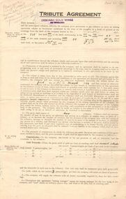 Bendigo Historical Society Inc.
Document - MCCOLL, RANKIN AND STANISTREET COLLECTION: DEBORAH MINES NL - TRIBUTE AGREEMENT, 1934
Document: McColl, Rankin and Stanistreet: Deborah Gold Mine NL 4 copies of tribute agreements Foolscap document, agreements made between Deborah Gold Mines NL and P. Flanagan, 6 Bancroft Street, Bendigo, D. McMahon 109 Olinda Street, Bendigo, L. Balle and L. Castle, Adams Road. A. Randall, Bellevue Road, L. Watt, Allingham Street, Joseph Hocking, Bellevue Road, Golden Square, Allan Randall, Bellevue Road, Golden Square.organization, mining, deborah gold mine nl tribute mining, mccoll, rankin and stanistreet: deborah gold mine nl, goldmining, mining, tribute mining -
 Kew Historical Society Inc
Photograph - Clifton Hotel, Kew Junction, 1994
Of the eight hotels established in Kew since European settlement, The Hotel Kew, known for most of its existence, as the Clifton Hotel was the seventh to be built in 1868. Its location on the corner of Studley Park Road and High Street at Kew Junction makes it a prominent landmark. Its current name is confusing for local historians as its main rival for the first 52 years was O'Shaughnessy's Hotel (1855), later renamed the Kew Hotel, on the corner of High Street and Denmark Street. Looking at the façade of the Hotel Kew, it is hard to imagine its mid-nineteenth appearance. There have probably been at least four renovations or rebuilding(s) of the structure. The documented renovations have occurred in the 1930s when the late Victorian façade was given an Art Deco update. In about 1970 its façade was again 'improved'. The many publicans who have held the licenses of the Clifton Hotel have been identified in in the 'Tetlow Index' and on the 'Boroondara Local History Wiki'. The most significant of these are Henry Madden (1880-87); Michael O'Donnell (1902-1920); and the Cronin-Ryan family (1935–53ff).Fading colour positive photograph of the Clifton Hotel at Kew Junction on the corner of High Street South and Studley Park Road. The hotel had been modified extensively over time, disguising the original Italianate facade. This is the colour scheme of the fourth restoration, including huge advertising billboards on the roof.Reverse: "Clifton Hotel. Studley Park Road at Kew Junction. 1994clifton hotel -- kew (vic.), hotels -- kew (vic.), kew junction