Showing 3383 items
matching run
-
 St Kilda Historical Society
Photograph - Photo map, 30/01/1960
One of a series of photo-maps produced for the Department of Crown Lands and Survey (1857-1983). For correlation with a current map, and access to other historical photo maps of Victoria, see the Historic Photo-Maps Index published by the Department of Environment, Land, Water and Planning at https://services.land.vic.gov.au/DELWPmaps/historical-photomaps/Black and white aerial photographVic 1091-110 Melbourne & Metropolitan Project Run 23East 30.1.60 Lens 10" 8.200elwood, elsternwick, elsternwick park, ripponlea, st kilda east, caulfield, balaclava, 1960 -
 St Kilda Historical Society
Photograph - Photo map, 30/01/1960
One of a series of photo-maps produced for the Department of Crown Lands and Survey (1857-1983). For correlation with a current map, and access to other historical photo maps of Victoria, see the Historic Photo-Maps Index published by the Department of Environment, Land, Water and Planning at https://services.land.vic.gov.au/DELWPmaps/historical-photomaps/Black and white aerial photographVic 1091-1 Melbourne & Metropolitan Project Run 24East 30.1.60 Lens 10" 8.200elwood, elwood beach, elwood park, 1960 -
 St Kilda Historical Society
Photograph - Photo map, 30/01/1960
One of a series of photo-maps produced for the Department of Crown Lands and Survey (1857-1983). For correlation with a current map, and access to other historical photo maps of Victoria, see the Historic Photo-Maps Index published by the Department of Environment, Land, Water and Planning at https://services.land.vic.gov.au/DELWPmaps/historical-photomaps/Black and white aerial photographVic 1091-2 Melbourne & Metropolitan Project Run 24East 30.1.60 Lens 10" 8.200elwood, elwood park, elwood beach, elsternwick park, 1960 -
 Ballarat Tramway Museum
Photograph - Black & White Photograph/s, Wal Jack, Sep. 1946
Has a strong association with the event that celebrated tram No. 27 reaching 1,000,000 miles in 1966, in Ballarat itself, although this was later shown by the BTPS when records audited to be 900,000 miles. Used on the TMSV tour tram.Black & white photo of North East Ballarat, taken from Sovereign Hill, Sept 1946. On rear has 'Ballarat East from Golden Mount Lookout'. Geelong Road at bottom of hill. Black Hill and lookout in background on left. Smoke from Sawmill' in black ink. Reimaged 17/7/2017 both front and back.As in content description. In blue ink on base of photo is 'Sept. 1946', ink has run in paper.trams, tramways, ballarat, sovereign hill, golden mount lookout -
 Bendigo Historical Society Inc.
Document - BASIL MILLER COLLECTION: TRAMS - EASTER TIMETABLES
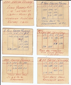
A series of handwritten notes on card, (16 Pieces), relating to run times for various sections of numerous tram routes across Bendigo.person, individual, basil miller -
 Bendigo Historical Society Inc.
Document - BASIL MILLER COLLECTION: TRAMS - RETURNING, c1974
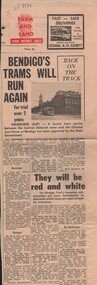
News paper clipping. Bendigo Advertiser, 13 September 1974. Bendigo Trams Will Run Again, for trial over 2 years.person, individual, basil miller -
 Bendigo Historical Society Inc.
Book - HOW TO RUN A PATROL, 1920
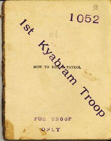
How To Run A Patrol 65 pages a handbook for patrol leaders and scoutmasters. Stamped 1st Kyabram Troop for troop only 1052John Lewisbooks, technical, scouts -
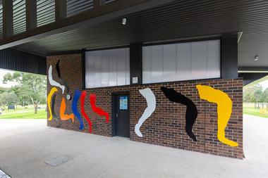 Yarra City Council
Artwork, other - Mural/Installation, Julia Gorman, Opening Lines, 2020
"The work gestures towards Utopian, modernist public art, like that of Miro, Matisse and Sainte-Phalle, but I was also inspired by Yarra's own Keith Haring murals, in the way that he repeats his personal iconography to fill a chosen space. I wanted to make an expansive, open and inclusive artwork. I drew legs from women playing footy, cricket and soccer, but tried to draw them in the least heroic, least literal way possible." Commissioned as part of an upgrade project at the Malcolm Graham Pavilion, Kevin Bartlett Reserve, Burnley, 2020. The existing facilities were upgraded to include female change rooms and amenities. The project funding comes from Yarra City Council and the State Government through its Female Friendly Facilities Fund. The commission is a result of Yarra's Public Art Policy 2015 - 2020 which ensures Council commits a percentage of the capital works budget for new community infrastructure projects. Matisse and Sainte-Phalle, Keith Herring, Miro, ModernistCopyright the artistA series of abstracted legs in various shapes that jump, kick and run across the wall, activating and animating the space with bold, bright colours.accompanying plaquesport, women, installation, modernism -
 Whitehorse Historical Society Inc.
Map, Campbell's Croft, c1970
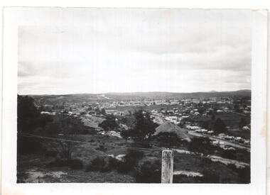
Enlarged aerial photograph of the area around Campbell's Croft Reserve. State aerial Survey, Melbourne, 1970 project. Run 37Enlarged aerial photograph of the area around Campbell's Croft Reserve. State aerial Survey, Melbourne, 1970 project. Run 37Enlarged aerial photograph of the area around Campbell's Croft Reserve. State aerial Survey, Melbourne, 1970 project. Run 37campbells croft, boronia road, vermont, madonna court, vermont, aerial photographs -
 Whitehorse Historical Society Inc.
Photograph, Mayoral functions
The occasion was the opening to the public of Pat Faggeter's garden, raising funds for the mayoress' committee c1961 when Doug Barelli was Mayor. From left to right. Linnell Barelli, Douglas Barelli, Pat Faggeter, Corinne Kirby (ABC presenter), Edward Faggeter.Black and white photograph of five people - two men and three ladies at a function run by the Mayoress to raise money for local associations.barelli, linnell, kirby, corinne, faggeter, pat, doug, edward, mayors, mayoress -
 Lakes Entrance Historical Society
Photograph - Fun Run, Lakes Post Newspaper, 1993
number in album 03358.03Black and white photograph three women Pam Pendlebury, Val Gilber, unknown, participants in Fun Run. Lakes Entrance Victoriacharities, sports -
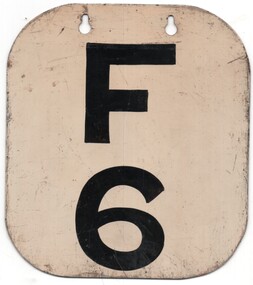 Melbourne Tram Museum
Functional object - Run Number Plate, Melbourne & Metropolitan Tramways Board (MMTB), Footscray F6, 1950's?
.Run Number metal plate with corners trimmed and rounded, two slotted holes, painted with a white background and the letter "F" and number "6" painted in black, to give a Run Number Plate for Footscray Depot. Painted with the same detail on either side of the plate. Advised by the donor that it was acquired just after the closure of the Footscray tram service.trams, tramways, mmtb, footscray depot, timetables -
Glenelg Shire Council Cultural Collection
Document - Ticket - See How They Run (by the Glenelg Players), May-59
Ticket, green card with black lettering for "See How They Run", by the Glenelg Players at Casterton Town Hall on Monday May 11, 1959.Back: 'C8' - blue biroamateur dramatics, local theatre, glenelg players, play -
NMIT (Northern Melbourne Institute of TAFE)
Brochure: Free English classes for Adult migrants in the Northern Suburbs August 1984
A4 size 8 pages with a green cover with details of courses to be run at Preston College of TAFE, Adult Migrant Education, and LaTrobe Universitypreston college of tafe, prospectus, nmit -
 Bendigo Historical Society Inc.
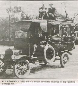
Newspaper - JENNY FOLEY COLLECTION: ALL ABOARD
Bendigo Advertiser "the way we were" from 1999. All aboard: a Cobb and Co. coach converted to a bus for the Huntly to Bendigo run.newspaper, bendigo advertiser, the way we were -
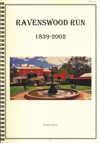 Bendigo Historical Society Inc.
Book - RAVENSWOOD RUN
Ravenswood Run 1839-2002, the history of from its very beginnings, 64 pages with black and white & colour photographs in a spiral binder.Rita Hullplace, land, ravenswood, history-ravenswood-bendigo-pastoral -
Whitehorse Historical Society Inc.
Article, Jobless given chance through a garden project, 1990
Article on Conjara Horticultural Project run by Harrison Youth ServicesArticle on Conjara Horticultural Project run by Harrison Youth Services to encourage long-term unemployed to find fulfilling full time employment.Article on Conjara Horticultural Project run by Harrison Youth Servicesyouth services, harrison youth services, unemployment, tyler, tracey, crowe, andrew, conjara horticultural project -
 Whitehorse Historical Society Inc.
Photograph, Wisteria Festival, 1/10/2002 12:00:00 AM
Coloured - Children listening to Brumbies' Bush Band; Wisteria Festival October 2002 at Schwerkolt Cottage run by Nunawading & District Historical Societywisteria festival, nunawading & district historical society, schwerkolt cottage, suto, joyce -
 Lakes Entrance Historical Society
Photograph - Lakes Entrance Secondary School, Lakes Post Newspaper, 1999
Colour photograph students Shannon Shreja and Megan Stott Secondary College holding trophies after Fun Run. Lakes Entrance Victoriaschools, sports, trophies & awards -
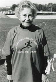 Lakes Entrance Historical Society
Photograph - Terry Fox Run, Lakes Post Newspaper, 1996
Number in album 03342.03Black and white photograph taken at Terry Fox Fun Run to raise funds for Cancer Research, of Dot Mortimer. Lakes Entrance Victoria volunteering, fundraising, cancer council -
Linton and District Historical Society Inc
Book from lending library, Leslie Charteris, Meet the tiger : the first 'Saint' novel, 1928, reprinted 1941
Carrie Murrell ran a lending library from her newsagent's shop in Sussex Street. The stamp set used in this library is also in the LDHS collection (Registration No. 1754). Dates during which Miss Murrell ran the library are not known.Novel which was once in Carrie Murrell's privately run 'Linton Library'. Book has a plain green board cover. Pages 256Stamp on title page: "C. Murrell's / Linton Library". "498" written in pencil within the stamp.carrie murrell, c. murrell's linton library -
 Bendigo Historical Society Inc.
Newspaper - JENNY FOLEY COLLECTION: HOME RUN
Bendigo School of Mines held it's own baseball competition between departments, dating from about the 1930's. Other Schools of Mines, eg Ballarat, did the same. They then held interschool matches. It is assumed that this photo is of the Bendigo inter-school team.Bendigo Advertiser '' The way we were'' from 2002. Home run: the Bendigo School of Mines baseball team of 1946. The clip is in a folder.newspaper, bendigo advertiser, the way we were -
Glenelg Shire Council Cultural Collection
Photograph - Photograph - aerial view of Portland, c. 1954
Black and white aerial photograph of coastline around Portland. Black border, scale all sides, 5 rows of 3 't' at regular intervals. Small area of ocean, rest land with lakes.Front: '820 -9' - handwritten, white, border 'RUN 5' 'PORTLAND', printed, white, lower borderaerial photography, central portland, portland harbour, coastline -
 St Kilda Historical Society
Photograph - Photo map, 28/01/1951
One of a series of photo-maps produced for the Department of Crown Lands and Survey (1857-1983). For correlation with a current map, and access to other historical photo maps of Victoria, see the Historic Photo-Maps Index published by the Department of Environment, Land, Water and Planning at https://services.land.vic.gov.au/DELWPmaps/historical-photomaps/Black and white aerial photograph1424-45 SECRET 534 Run 18 Lens 12" Melbourne Metropolitan 12150 28.1.51 M639albert park, st kilda junction, st kilda pier, catani gardens, st kilda, prahran, albert park lake, 1951, middle park, st kilda beach, windsor -
 St Kilda Historical Society
Photograph - Photo map, 12/04/1966
One of a series of photo-maps produced for the Department of Crown Lands and Survey (1857-1983). For correlation with a current map, and access to other historical photo maps of Victoria, see the Historic Photo-Maps Index published by the Department of Environment, Land, Water and Planning at https://services.land.vic.gov.au/DELWPmaps/historical-photomaps/Black and white aerial photographVic 1933 Melbourne 1966 Project Run 12 12.4.66 Lens 122 151.75MM 9.800 152st kilda, st kilda pier, st kilda marina, albert park, fawkner park, windsor, south yarra, prahran, st kilda west, middle park, st kilda beach, 1966 -
 St Kilda Historical Society
Photograph - Photo map, 12/04/1966
One of a series of photo-maps produced for the Department of Crown Lands and Survey (1857-1983). For correlation with a current map, and access to other historical photo maps of Victoria, see the Historic Photo-Maps Index published by the Department of Environment, Land, Water and Planning at https://services.land.vic.gov.au/DELWPmaps/historical-photomaps/Black and white aerial photographVic 1933 Melbourne 1966 Project Run 12 12.4.66 Lens 122 151.75MM 9.800 154st kilda, st kilda east, balaclava, toorak, amadale, caulfield, south yarra, st kilda botanical gardens, peanut farm, 1966 -
 St Kilda Historical Society
Photograph - Photo map, 12/04/1966
One of a series of photo-maps produced for the Department of Crown Lands and Survey (1857-1983). For correlation with a current map, and access to other historical photo maps of Victoria, see the Historic Photo-Maps Index published by the Department of Environment, Land, Water and Planning at https://services.land.vic.gov.au/DELWPmaps/historical-photomaps/Black and white aerial photographVic 1933 Melbourne 1966 Project Run 12 12.4.66 Lens 122 151.75MM 9.800 155 -
 St Kilda Historical Society
Photograph - Photo map, 13/01/1968
One of a series of photo-maps produced for the Department of Crown Lands and Survey (1857-1983). For correlation with a current map, and access to other historical photo maps of Victoria, see the Historic Photo-Maps Index published by the Department of Environment, Land, Water and Planning at https://services.land.vic.gov.au/DELWPmaps/historical-photomaps/Black and white aerial photograph2138 State Aerial Survey Melbourne 1968 Proj. Run 26 13.1.68 5100 ASL 203st kilda west, albert park, fawkner park, south yarra, prahran, windsor, 1968 -
 St Kilda Historical Society
Photograph - Photo map, 11/01/1968
One of a series of photo-maps produced for the Department of Crown Lands and Survey (1857-1983). For correlation with a current map, and access to other historical photo maps of Victoria, see the Historic Photo-Maps Index published by the Department of Environment, Land, Water and Planning at https://services.land.vic.gov.au/DELWPmaps/historical-photomaps/Black and white aerial photographVic 2132 State Aerial Survey Melbourne 1968 Proj. Run 27E 11.1.68 5100 ASLst kilda, st kilda west, st kilda pier, catani gardens, st kilda beach, albert park, 1968 -
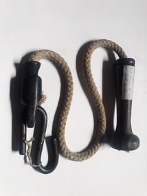 Melbourne Tram Museum
Functional object - Tramcar component, Melbourne & Metropolitan Tramways Board (MMTB), Bell cord - for a grip car bell, c1920?
A souvenir from one of the last trams to Port Melbourne. Both the South Melbourne and Port Melbourne cable lines closed on this date. The South Melbourne line was converted to electric traction; the Port Melbourne line was replaced by a bus service. See item 7595 for another bell cord from the same event.Has a close association with the closure of the Port Melbourne cable tram line.Bell cord - for a grip car bell - consisting of a wooden turned handle fitted with a screw at the bottom, a length of sash cord and a cast iron end to which the rope has been glued or fastened into and a hook that went on the underside of the bell itself. On the wooden handle is a label - "Cable tram cord taken from the last tram to run in Port Melbourne"trams, tramways, cable trams, grip tram, gripmen, bell, port melbourne, last tram, closure