Showing 1520 items matching "sanding"
-
 Lakes Entrance Historical Society
Photograph - Snowy River Marlo Victoria
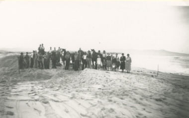
Number 1 in series of fiveBlack and white photographic print showing excavation of an entrance to the ocean at the mouth of the Snowy River with Cape Conran in distance on right. Group of workmen and visitors with horses and scoops on sand Marlo Victoria. Number 1 in series of fivetownship, rivers -
 Lakes Entrance Historical Society
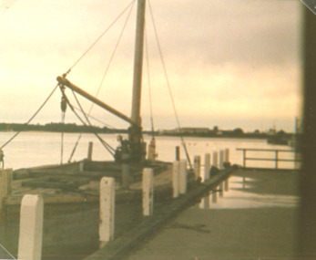
Photograph, Vera Bennett, Lady Harriet barge, Lakes Entrance Victoria, 14/06/1989 12:00:00 AM
Also a second photograph showing notice inside barge 04674.1 10 x 15 cmSepia toned photograph showing Lady Harriet barge moored at P.O. wharf on Cunninghame Arm, bullock Island and sand dunes in distance, Lakes Entrance Victoria. Also a second photograph showing notice inside barge Old stone barge that transported stone from Mississippi Creek Auary at the P.O. Jetty 14. 6. 89boats and boating, jetties, waterways -
 Lakes Entrance Historical Society
Postcard, Bulmer, Scene from Jemmys Point, 1900 c
Black and white postcard showing view from Jemmys Point of east end of Rigby Island and Reeves channel the entrance and sand dunes with Hope channel in distance Lakes Entrance Victoria.Also another copy of same postcard township, waterways, islands -
 Queenscliffe Maritime Museum
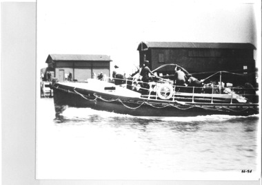
Photograph - Photo of the Lifeboat QUEENSCLIFFE heading out, Photograph of lifeboat QUEENSCLIFFE, March 1936
The QUEENSCLIFFE lifeboatLifeboatsblack & white photograph of the Lifeboat QUEENSCLIFFE, probably after the early 1930'sReverse - "Fisherman's Pier (demolished about 1955) - (c1947-49) - lifeboat shed before moved to new pier because of "sanding-up"- P & H [Ports & Harbour] shed on left [on S arm of Fisherman's Pier]"community information, the queenscliffe lifeboat -
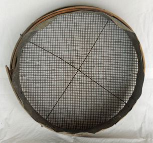 Orbost & District Historical Society
sieve, First half 20th century
Possibly used for sieving bean seeds or corn seeds. Could have been a sand sieve.A round wooden framed sieve. It has a double frame with 1/4 " wire mesh held in through two frames. It has a galvanised iron inset.sieve agriculture tool -
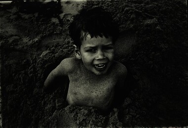 Federation University Historical Collection
Photograph, Paul Lambeth, Tom Lambeth, c1986
Associated with lecturer Paul Lambeth's photography class. Different textures and tonal qualities. skin and sand. Black and white photograph adhered to card. Tom Lambeth at Lorne.in pencil on verso "Tom Lambeth"tom lambeth, photography, paul lambeth. -
 Lakes Entrance Historical Society
Postcard - Lakes Entrance viewed from Jemmys Point, Rose Series, 1925 c
Post and rail fence beside highway and no vegetation on sand dunes eastern part of Cunninghame ArmBlack and white postcard showing view of Cunninghame Arm from Jemmys Point, gravel Princes Highway, North Arm bridge and end of town Lakes Entrance VictoriaNearing Lakes Entrance on the Princes Highwaytownship, waterways -
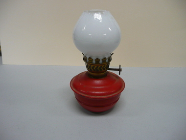 Bendigo Historical Society Inc.
Domestic Object - SMALL KEROSENE LAMP
Small red tin plate kerosene childs night light commonly called Pixie lamps, base filled with gravel or sand to prevent tipping over, small milk white glass chimney, brass burner complete with wick.Wick winder reads GWB British madelighting, kerosine & oil, kerosene -
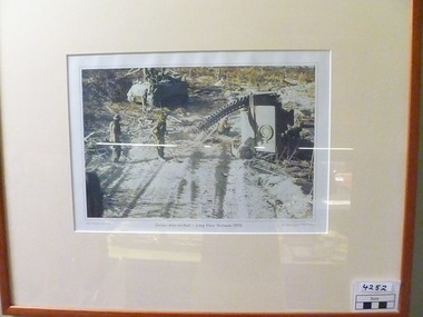 National Vietnam Veterans Museum (NVVM)
Photograph, 1970
Colour photograph of two APC's.One is on the side - damaged.Its track is lying on the sand track - Results of landmine incident.Personnel from damaged vehicle attend to necessary tasks including detecting for other mines.Tan coloured frame and cream coloured mat.Serious mine incident - Long Hais, Vietnam.1970. My Vietnam Collection. C. Bud Costello / Phil Kadow.photograph, apc -
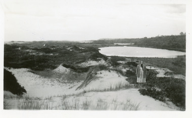 Lakes Entrance Historical Society
Photograph, 1950c
Also enlargement 15x25cmBlack and white photograph of the Warm Holes, from the sand hummocks looking west. The Warm Holes are the remnant of Reeves River, the original waterway from the Gippsland lakes to the natural entrance. Lady with shawl in foreground. Lakes Entrance Victoria waterways, topography -
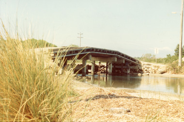 Lakes Entrance Historical Society
Photograph - Bridges, Fish Marie, 1965
Also one other photograph, similar viewColour photograph of the first road bridge from Lakes Entrance to Bullock island, which was built for Public Works Dept. groyne building and sand build up to enlarge the island. Built early 1953. Lakes Entrance Victoria topography, bridges, islands, public works -
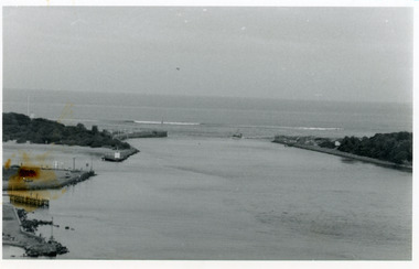 Lakes Entrance Historical Society
Photograph - The Entrance, 1986
Black and white photograph of the entrance from Bass Strait to the Gippsland Lakes. It also shows the rock groynes at Bullock Island filled with dredged sand to extend the island. Fishing boat coming through entrance. Lakes Entrance Victoriaislands, topography, waterways -
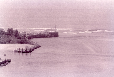 Lakes Entrance Historical Society
Photograph - The Entrance, Fish Marie, 1995
Black and white photograph of the Eastern Pier, taken from Jemmys Point. It shows the rock wall of the pier, rock groynes at the entrance to Cunninghame Arm behind which dredged sand has been dumped. Lakes Entrance Victoria waterways, piers -
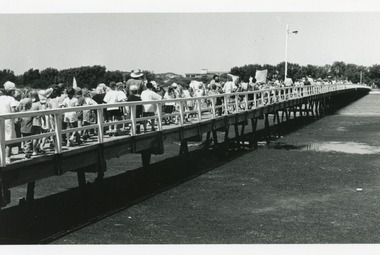 Lakes Entrance Historical Society
Photograph - Footbridge, 1993c
Black and white photograph showing crowd of tourists walking over footbridge, during the Clear Water Festival, water in foreground is known as Cunninghame Arm. Surf lifesaving club building visible on sand dunes. Lakes Entrance Victoriabridges, waterfront, festival -
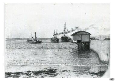
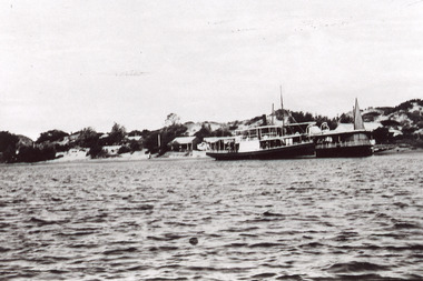 Lakes Entrance Historical Society
Photograph - New Works Jetty, 1920 c
Also one black and white copy of the same image.Black and white photograph showing two steamers at New Works wharf, Cunninghame Arm,Cottages on dune behind steamers. Top of sail visible behind steamer. Sand showing between vegetation on dunes. Lakes Entrance Victoria.ships and shipping, waterways, jetties, islands -
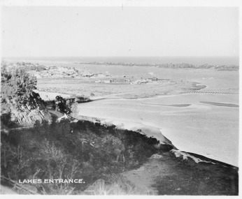 Lakes Entrance Historical Society
Postcard - View from Jemmys Point, 1930c
Sepia toned small format postcard of a view from Jemmys Point, showing the road cutting around Kalimna Hill, North Arm bridge, town of Lakes Entrance, Cunninghame Arm and sand hummocks, Lakes Entrance VictoriaLakes Entrancewaterways, township, roads and streets -
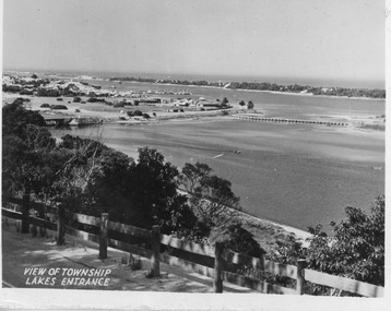 Lakes Entrance Historical Society
Postcard - North Arm bridge Lakes Entrance Victoria, 1947c
Black and white small format postcard showing town, North Arm bridge, post and rail fence beside the road, bridge to Bullock Island, Cunninghame Arm and sand hummocks, motor boat on the lake. Lakes Entrance VictoriaView of Township Lakes Entrancebridges, township -
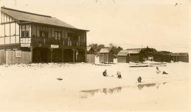 Chelsea & District Historical Society Inc
Photograph - Edithvale Life-Saving Club, Clubhouse, 1920's - 1930's
Edithvale Life Saving Club was founded in 1919.Sepia postcard of Edithvale Life-Saving Club, a double story wooden building, built on the foreshore of Edithvale beach. Bathing boxes are on the right hand side, with boats sitting on the sand and three children playing, while a man watches.Kiosk and beach, Edithvale Valentine series no 198life saving club, edithvale, edithvale beach, bathing boxes -
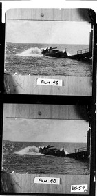
 Flagstaff Hill Maritime Museum and Village
Photograph - Historical, maritime, 1900s to 1930s
... sanding ...This photograph shows the steam dredge Pioneer working to remove silt in Lady Bay, Port of Warrnambool. The dredge belonged to the Ports and Harbours department in Melbourne. Also in the photograph are two moored vessels, and the Warrnambool Lifeboat shed and Rocket house built on the Warrnambool Breakwater. The Warrnambool Harbour had been experiencing heavy silting and sanding for many years. The problem continued even after the construction of the Breakwater in 1890. The Ports and Harbours' new, larger suction hopper dredge, the Matthew Flinders, was also employed in May 1919 to remove the heavy silting in the Harbour. Both dredges were sent up from Melbourne when required over the years to periodically attend to the silting. The Matthew Flinders was still dredging the Harbour even in the 1930s. (The ship’s original master was J G Rosney. In February 1922 Percy Taylor from Ports and Harbours joined the Matthew Flinders as a Mate. 1923 the master in charge was Captain Dunbar. In August 1926 Percy Taylor was appointed as her Master and was later transferred to the Pioneer as Master in 1933.) 1930 the dredges were no longer required as the Harbour was no longer suitable as a port. However, one source notes that the Matthew Flinders was still dredging the Harbour in 1938.This photograph is significant for its association with the Port of Warrnambool, the Warrnambool Breakwater, and the issue of the silting in Lady Bay. The photograph is significant historically as it shows a point in time when efforts were employed to keep the Port of Warrnambool functioning, allowing shipping activities to continue operating. The need for dredging in the Warrnambool Harbour was a serious and ongoing problem, as silting continued to happen after a series of measures were taken to try and resolve the issue. Eventually, the Harbour could no longer function successfully as a port.Photograph, black and white, showing two similar images and printed together. Images of Lady Bay, Warrnambool, the dredge 'Pioneer' on the left, ships and the Warrnambool Lifeboat and Rocket House on the right, beside the Breakwater. Ca. 1900 to 1930."BL016"flagstaff hill, warrnambool, maritime village, maritime museum, flagstaff hill maritime museum & village, dredge, mathew flinders i, warrnambool harbour, lady bay, sanding, silting, breakwater, captain dunbar, ports & harbours, marine technology, percy taylor, matthew flinders, pioneer, dredge pioneer, lifeboat house, rocket house -
 National Wool Museum
Book, Sand Castles
"Sand Castles: the story of the development of Naranga in the Coonalpyn Downs district of South Australia" - Michael Elliott, 1990.pastoral industry - settlement farming, elliott and dibb, 'naranga', south australia, pastoral industry - settlement, farming -
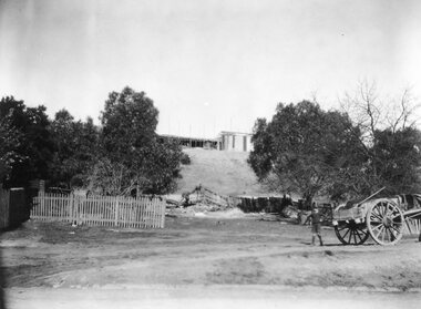 Stawell Historical Society Inc
Photograph, New Hospital under construction on the St George Sand Dump looking from Sloane Street
View from Sloane Street of St George Sand Dump site with New Hospital under construction.stawell hospital -
 Queenscliffe Maritime Museum
Photograph - Black & white photograph of lifeboat Queenscliffe launching, Photographer unknown, Photographs
Photos of the lifeboat QueenscliffeRealism, historicalBlack & white photographs of the lifeboat Queenscliffe launching from the lifeboat shed On the reverse - "P6A53 - lifeboat being launched [c1936] from the old fisherman's pier, north of the present pier boat shed dismantled & transferred to the present site on new pier because of sanding up preventing launch c1947-49 "" -
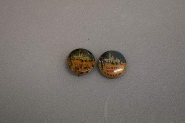 Warrnambool and District Historical Society Inc.
Badgesx2, Servia Syria Armenia, circa 1918
These badges were produced for the Commonwealth Button Fund to raise funds for the victims of the Armenian massacre in the Ottoman Empire during World War One. The button was designed by Frances Woolcot the Honorary Organiser of the Melbourne Branch of the Commonwealth Button Fund. The buttons were sold late in February 1918 and raised 7,300 pounds for the victims.February These badges are of interest as an example of the Australian fund raising efforts during World War One for a specific group of people - in this case the victims of the Armenian massacres..1 Concave metal badge featuring sky, a minaret, two onion shaped domes, buildings, sand, three mounted camels and palm trees. There is a clip pin on the reverse. .2 As for .1 but discoloured and there is no slot into which the pin may be inserted. SERVIA SYRIA ARMENIA -
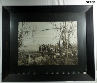 Bendigo Military Museum
Photograph - PHOTOGRAPH WW1, FRAMED, Golarts Studios, Post WW1
Photo of Artillery Battery Gun Emplacement. Field gun supported with sand bag wall. Gun crew preparing site for action. Black & white photo mounted in black wooden frame with black border, cardboard backing, glass front. Front RHS bottom & back, LHS bottom: “No 53 stickers” Back LHS bottom: “Trust No 22”photography-photographs, frame accessories, military history, arms-ordnance, passchendaele barracks trust -
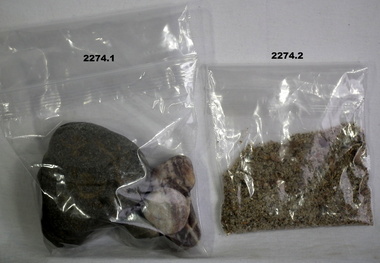 Bendigo Military Museum
Souvenir - SOUVENIRS, ANZAC COVE, Post 1990
.1) Four rocks of various size from the beach on Anzac Cove .2) Sand from the beach at Anzac Cove .3) Cone from an aleppo pine grown on Gallipoli .4) Small round pine cone from Gallipolianzac, pines, minerals, souvenirs -
 Mission to Seafarers Victoria
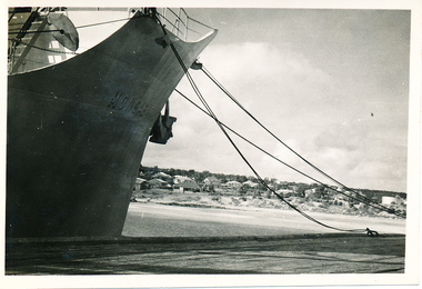
Photograph, M/S "Mongabarra" Goteborg, Tied up at Port Lincoln, April 1950
This series of photographs captures life at sea and the conditions on the ship M/S "Mongabarra" Goteborg in 1950.This photograph is part of the Allan Quinn collection, which is a pictorial autobiography, and it represents one of many moments of his time abroad as a seafarer.Black and white photograph of the M/S "Mongabarra" Goteborg tied up at Port Lincoln in April 1950. The ship is situated on the left-hand side of the photograph with ropes dug into the sand on the right-hand side of the photograph with Port Lincoln in the background.m.s. mongabarra, port lincoln, goteborg -
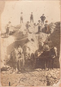 Bendigo Historical Society Inc.
Photograph - WORKERS ON OLD TOM SANDHEAP
Sepia toned photograph of Workers on Old Tom 'Sand heap O'Halloran's Team' Markings on photo read 'A. Levy & co' Within the photo are 2 horses and carts as well as 9 male workers. Old Tom Mine in Whipstick, Eaglehawk.A Levy & Coperson, group, group of workers, old tom sand heap, mining, workmen, horse and buggies, o'halleran's team -
Lakes Entrance Historical Society
Photograph, Eastwood Bros, 1889c
Sepia photograph showing the just opened Entrance to Bass Strait. Sand not completely cleared from channel, buildings on dunes, dredge Wombat moored off Bullock Island. Rock groynes being built in lake. Lakes Entrance Victoriawaterways, islands, jetties, houses -
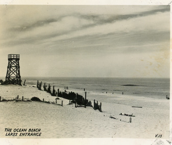 Lakes Entrance Historical Society
Postcard - Ocean Beach, 1950c
Black and white small format postcard of the ocean beach. It shows an expanse of sand dune, remains of a brush windbreak fence, and the observation tower, built for Royal Lifesaving Club, pre Surf Life Saving Club. Lakes Entrance VictoriaThe Ocean Beach Lakes Entrancebeaches, surf lifesaving -
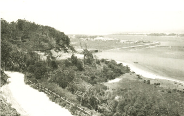
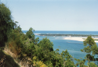 Lakes Entrance Historical Society
Photograph - The Entrance, 1992c
Colour photograph of the western side of the Entrance. It shows scrub covered hummocks, dredged sand dumped at Snake Island, rock groynes from island to lake, taken from lower side of highway at Jemmys Point. Lakes Entrance Victoriaislands, topography, waterways