Showing 682 items
matching slater
-
 Eltham District Historical Society Inc
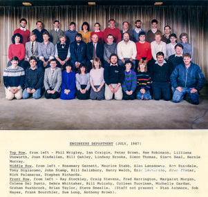
Photograph, Staff Photo, Engineers Department, Shire of Eltham, July, 1987 (with names), 1987
Top Row, from left - Phil Wrigley, Ian Craigie, Peter Brown, Rae Robinson, Lilliana Unsworth, Joan Kindellan, Bill Oakley, Lindsay Brooks, Simon Thomas, Simon Beal, Bernie Murray. Middle Row, from left - Rosemary Garnett, Maurice Stabb, Alan Lansdowne, Ron Dinsdale, Tony Digiacomo, John Stamp, Bill Salisbury, Barry Welch, Ezio Lattanzio, Greg Slater, Nick Palamaras, Stephen Richards. Front Row, from left - Ray Stockley, Craig Stevens, Fred Harrington, Margaret Morgan, Colene Dal Santo, Debra Whittaker, Bill Mulcahy, Colleen Tuovinen, Michelle Gardam, Graham Rushbrook, Brian Taylor, Steve Smeelie. (Staff not present - Stan Ashmore, Bob Hayes, Frank Bourchier, Sue Long, Anthony Brown).Two colour photographs, laminated, with typed list of names 2 copies; 22.5 x 27 cm laminated (12.5 x 20 cm photo)Originally contained in an envelope with handwritten note on enveloe to Allan Baker dated 14 Dec 1987 "Enclosed for your use are staff photos of all departments. I've given each Champion of Committees copies for all their respective Councillor photos of Depts reporting to each committee. Outdoor staff photos will be taken next week and I'll make those available as soon as possible. Cheers (Undecipherable)"shire of eltham, council staff -
 Ballarat Heritage Services
Photograph - Photograph - Colour, Clare Gervasoni, Former School at Weatherboard, Victoria, c2010
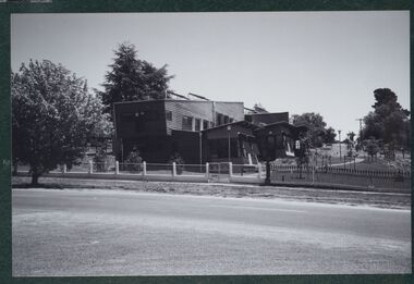
Weatherboard is a small town in Western Victoria.Anecdotally the name is thought to have originated because it was the first place in the region to have a home built using weatherboard rather than corrugated iron, stone or bricks. It is in the boundaries of the City of Ballarat. The School, Number 656, was opened on 01 August 1862 and closed on 04 February 1948. it was also known as Weatherboard Hill Common School and Weatherboard Hill State School.The bluestone school building had a slate roofand its first head teacher was James Richmond..In 1915 Health Officer, Dr Willis, strongly condemned the old bluestone building as being damp and unsanitary. in 1948 enrolments dropped to 6 and the school closed. The Weatherboard State School World War One Honour Board is located at Burrumbeet Hall. An early bluestone school known as the Weatherboard School.weatherboard school, former weatherboard school, education, weatherboard hill common school, weatherboard hill state school -
 Bendigo Military Museum
Photograph - Army Survey Regiment’s Fortuna Lions Football Club Grand Finals, Seymour, Victoria, 1983
This is a set of 27 black & white photographs of Army Survey Regiment’s Australian Rules football team – the Fortuna Lions aka “Fortuna Fumblers”, taken at Seymour Victoria in 1983. The Fortuna Lions competed in the Puckapunyal Area Football Association for several years from 1978 to 1984 and in 1983, fielded a great team it managed to reach the Grand Final. Held at the neutral ground at Kings Park, Seymour, the match was an incredibly exciting and bruising contest played in damp conditions and ended in a draw. Dave Lawler’s spectacular mark was a highlight. Due to heavy rain during the following week, the Grand Final replay was held the following week in even heavier conditions. The Fortuna Lions prevailed in the replay with an emphatic victory. The team’s leaders were Eddie Jacobs (coach), Rhys De Laine (captain), Greg Else (vice-captain), and Ken Slater (manager). See item 6274.7P for more photographs taken at the two grand finals, team photo. See item 6245.26P for colour photos of the finals, the team photo with names and a photo of the premiership banner. The team changed its name to the Fortuna Falcons and its guernsey to gold with a blue ‘V’ in 1988 and continued to compete in the competition up to 1995. This is a set of 27 black and white photographs of Army Survey Regiment’s Australian Rules football team – the Fortuna Lions aka “Fortuna Fumblers”, taken at Seymour Victoria in 1983. The photographs were printed on photographic paper and are part of the Army Survey Regiment’s Collection. The photographs were scanned at 300 dpi. Players named below are in Fitzroy jumpers. .1) - Photo, black and white. 1983. L to R: Mick Hogan, Peter Jones (ruck), Rod Skidmore (No.14), Greg Else, Stu Ridge (No.2). .2) - Photo, black and white. 1983. L to R: Rhys De Laine, Doug Home, Mick Hogan (no.12), Rod Skidmore. .3) - Photo, black and white. 1983. L to R: unidentified (x2), Keith Quinton, Doug Home, Mick Hogan. .4) - Photo, black and white. 1983. L to R: Rod Skidmore, Greg Byers, Rhys De Laine, Rhys De Laine, Jim Ash. .5) - Photo, black and white. 1983. L to R: Stu Ridge (No.2) Peter Jones (ruck No.5), Mick Hogan. .6) - Photo, black and white. 1983. L to R: Keith Quinton (No.3), unidentified (No.8), Dennis Learmonth, Greg Byers. .7) - Photo, black and white. 1983. L to R: Greg Byers, Greg Higgins, Stu Ridge, Dennis Learmonth (No.10), Keith Quinton. .8) - Photo, black and white. 1983. L to R: Bob Thrower (No.21), Peter Jones, Dennis Learmonth (No.10). .9) - Photo, black and white. 1983. L to R: all unidentified. .10) - Photo, black and white. 1983. L to R: Mick Hogan (no.12), Doug Home, Peter Jones (No.5), Greg Else, Jim Ash. .11) - Photo, black and white. 1983. L to R: Dennis Learmonth, Keith Quinton. .12) - Photo, black and white. 1983. L to R: unidentified, Eddie Jacobs (No.16), Greg Higgins (No.20). .13) - Photo, black and white. 1983. L to R: all unidentified. .14) - Photo, black and white. 1983. L to R: Rod Skidmore, Jim Ash. .15) - Photo, black and white. 1983. L to R: Greg Else (No.6), Mick Hogan (No.12), Alan Staley, unidentified. .16) - Photo, black and white. 1983. L to R: unidentified, Peter Jones, Rhys De Laine. .17) - Photo, black and white. 1983. L to R: Eddie Jacobs, Greg Else. .18) - Photo, black and white. 1983. L to R: Keith Quinton (No.3), Rod Skidmore, Eddie Jacobs, Dave Lawler. .19) - Photo, black and white. 1983. L to R: Doug Home, Greg Byers, Bob Thrower, Rod Skidmore, unidentified. .20) - Photo, black and white. 1983. L to R: Stu Ridge (No.2), Greg Higgins (No.20), unidentified (No.8). .21) - Photo, black and white. 1983. L to R: all unidentified. .22) - Photo, black and white. 1983. L to R: Peter Jones (no.5), Greg Byers (No.19), unidentified (x2). .23) - Photo, black and white. 1983. L to R: unidentified. .24) - Photo, black and white. 1983. L to R: Mick Hogan, unidentified (no.13), Rhys De Laine, Jim Ash, Keith Quinton (No.3). .25) - Photo, black and white. 1983. L to R: Steve Burke, Peter Dillon, Jim Ash, Dave Lawler, Paul Baker, Tracy Ash, unidentified, Warren Hall. In far-right background: Greg Else, Megan Reynolds. .26) - Photo, black and white. 1983. L to R: Warren Hall, Ken Slater, Cliff Webb, shirtless Glen Cannon. .27) - Photo, black and white. 1983. L to R: Warren Hall, unidentified..1P to .27P – no annotationsroyal australian survey corps, rasvy, army survey regiment, army svy regt, fortuna, asr -
 Bendigo Historical Society Inc.
Newspaper - JENNY FOLEY COLLECTION: SNIPPETS OF BENDIGO HISTORY
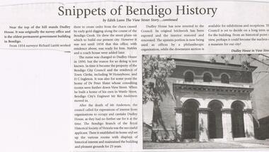
Bendigo Weekly date unknown. '' Snippets of Bendigo history'' by Edith Lunn the View Street story continued. In this article Edith Lunn describes Dudley House, originally the survey office and the oldest permanent government building in Bendigo. From 1854 surveyor Richard Larritt worked there. It was in 1890 that the name Dudley house was attached to the building. Town clerks W. Honeybone and H.C. Inleton lived there. Later it was the home of Dr. Peter Slater, after he moved out city engineer Mr. Rex Anderson moved in. After his death the Bendigo branch of the Royal Historical Society of Victoria established its home there after 25 years Dudley House reverted to the Council. The clip is in a folder.newspaper, bendigo, bendigo weekly -
 Kew Historical Society Inc
Photograph - Victorian Double-fronted Brock Villa, Cotham Road, c. 1919
The Kew Historical Society's map collection includes a substantial number of real estate subdivision plans, mainly of Kew but also of surrounding suburbs in Melbourne. Most of the subdivision plans date from the 1920s and 1930s when the districts old homes and local farmland were being split up to accommodate residential growth in the postwar period. These early plans were assembled by a local firm, Jas R Mather & McMillan, which had an office in Cotham Road. Many of the plans, and sometimes photos, were annotated by the agents.Subdivision plans are historically important documents used as evidence for the growth of suburbs in Australia. They frequently provide information about when the land was sold as well as evidence relating to surveyors and real estate and financial agents. The numerous subdivision plans in the Kew Historical Society's collection represent working documents, ranging from the initial sketches made in planning a subdivision to printed plans on which auctioneers or agents listed the prices for which individual lots were sold. In a number of cases, the reverse of a subdivision plan in the collection includes a photograph of a house that was also for sale by the agent. These photographs provide significant heritage information relating house design and decoration, fencing and household gardens.The photograph may also be aesthetically significant depending o the importance of the photographic atelier.Real estate photographs of a classic double-fronted late Victorian brick villa. It central location in Cotham Road, Kew enabled the selling agent to note its proximity to the tram. With seven rooms, all ‘modern conveniences’, and land of 66×167, the house was to be sold for £1100. The villa has a number of interesting features including a pattern within the slate roof as well as the use of polychrome brickwork under the eaves and on the façade. The intricacy of the cast iron lace is emphasised by the line of projecting wooden blocks above it. The picket gate is painted a different colour to the pickets of the fence. The house has a name (illegible) that is attached to the inset cast iron lace of the central projecting gable in the veranda. Stamped on mount: "Kew. Central. Close tram. / Comfortable Brick Villa. / Containing 7 rooms / Modern conveniences: / Land 66 x 167. Sold 1100 pounds:"houses - kew, victorian villas, real estate photographs, cotham road - kew -
 Federation University Art Collection
Artwork, other - Ceramic mural, John Gilbert, 'Enigmatic Land' by John Gilbert, 1973, 1973
ENIMATIC LAND OF BIRDS THAT SING FLOWERS FROMS SEEDS THAT SPRING OF REPTILES AND FISHES CREATURES FROM THE BEGINNING SUN AND MAN AND SCIENCE THE SYMBOLS THAT SILENTLY BUILD AND CHANGE IN COOL AND WARM YOU ARE THERE AND HERE OF YESTERDAY NOW THE SPLITTING EARTH MURAL BY JOHN GILBERT 1973John GILBERT (1935- ) Born Albury, New South Wales John Gilbert worked as a teacher while completing a Certificate of Art at the Technical College in Marlborough, before moving to Ballarat in 1958. He studied at the Ballarat Technical Art School, a division of the Ballarat School of Mines (1960-1961) receiving a Diploma of Art; and Croydon College of Art, London. Gilbert was a Senior Lecturer at the Ballarat Institute of Advanced Education (now Federation University) Art Department until his retirement in the late 1970s. In John Gilbert's Mount Helen studio he produced work marked with an incised 'Gilbert'. He had acquired a concern for form and an interest in sculpture from his teacher Neville Bunning, and from the British potter Hans Coper, whom he visited in 1968. He established two potteries in Ballarat , the Edinburgh Pottery (1972-2005) located within the Sovereign Hill precinct, and the Old Ballarat Pottery (1973-1994) located in the Old Ballarat Village opposite Sovereign Hill. This item is part of the Federation University Art Collection. The Art Collection features over 2000 works and was listed as a 'Ballarat Treasure' in 2007.A large ceramic mural by John Gilbert commissioned for the wall of the E.J. Barker Library. The mural features brown and green glaze with features of indigo. The work has no particular pictorial representation. It is an arrangement of colour and form, designed for enjoyment rather than to analyse. The theme relates to the development of the Universe through basic symbols such as plant forms, fish, birds and to mans development through symbols of science and engineering. The outer edge is symbolic of earths crust being peeled away to reveal science and nature. The mural depicts the changing of seasons from Winter to Summer (left to right). The mural was completed at John Gilbert's Slate Gallery studio, Mount Helen, and took eight months to make.gilbert, artwork, john gilbert, art, ballarat school of mines, mural, ballarat institute of advanced education, ballarat pottery, ceramics, old ballarat pottery, edinburgh pottery -
 Bendigo Historical Society Inc.
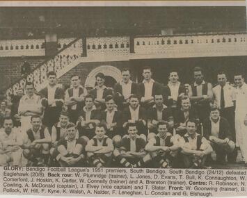
Newspaper - JENNY FOLEY COLLECTION: GLORY
BHS CollectionBendigo Advertiser ''The way we were'' from 2002. Glory: Bendigo Football League's 1951 premiers, South Bendigo. South Bendigo (24/12) defeated Eaglehawk (20/8). Back row: W. Plumridge (trainer), L. Jones, D. Evans, T. Bull, K. Connaughton, W. Comerford, J. Hoskin, k. Carter, W. Connelly (trainer) and A. Brereton (trainer). Centre: R. Robinson, N. Cowling, A. McDonald (captain), J. Elvey (vice captain) and T. Slater. Front: W. Goonwing (trainer), B. Pollock, W. Hill, F. Kyne, K. Walsh, A. Naider, F. Leneghen, L. Conolan and G. Elshaugh. The clip is in a folder.newspaper, bendigo advertiser, the way we were -
 Bendigo Military Museum
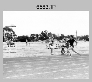
Photograph - Army Survey Regiment Inter-Squadron Athletics Competition, Bendigo, 1982
This is a set of six photographs of an Army Survey Regiment inter-squadron athletics competition held at Epsom, Bendigo in 1982. Personnel from Headquarters, Air Survey, Cartographic and Lithographic Squadrons took part in traditional athletics events, wheelbarrow race, sack race, fireman’s carry and tug-of-war novelty events. Photo .1P caption: FORTUNA RECORDS TUMBLE. ‘Super Sapper Annette Wilson of Air Survey Squadron broke a total of 4 records at the Army Svy Regt annual athletics carnival. She bettered the shot put by an amazing 5.10 metres, while also creating new records for the long jump, discus and javelin. The above photograph shows her winning the Womens 100 metre event.’ Photo .2P caption: ‘SPR Barry Miller of Headquarters/Operations Squadron leads CPL Keith Quinton of Lithographic Squadron out of the turn in the 200 metre mens open. SPR Barry Miller ran on strongly to win the vent.’ Photo .3P caption: ‘CPL Laurie Justin of Lithographic Squadron surges on to the straight to win the 800 metres mens open event.’ Photo .4P caption: ‘CPL Mick Hogan shows how to gain more distance in the air – as he wins the Triple Jump competition for Air Survey Squadron.’ Photo .5P caption: GET WITH THE STRENGTH – GO CARTO ‘Cartographic Squadron won the Tug-of-War competition after a desperate struggle provided by Headquarters/Operations Squadron. Pictured I the final heat of the competition, in which Carto Sqn were the eventual winners, 2 tugs to 1.’ Photo .6P caption: PROTEST UPHELD. ‘As a result of a protest in the running of the wheelbarrow race, a re-run was called for, much to the disappointment of the original winners. MAJ Stan Vote and WO1 Ken Slater of Lithographic Squadron. After wheel chocks had been removed from the wheelbarrow of the protesters, the race was re-run and first place went to MAJ Graham Baker and LT Chris Mazur of Air Survey Squadron.’This is a set of six photographs of an Army Survey Regiment inter-squadron athletics competition held at Bendigo in 1982. The photographs were printed on photographic paper and mounted on A4 paper, with typed captions underneath. The black and white photographs were scanned at 300 dpi. They are part of the Army Survey Regiment’s Collection. .1) - Photo, black & white, 1982, 100m sprint race. Foreground: SPR Annette (Wilson) Godden. Background L to R: SPR Chris Gordon, SPR Sherri (Dally) Burke, SPR Kristin (Isaac) Skidmore – obscured. .2) - Photo, black & white, 1982, 200m sprint race. L to R: CPL Keith Quinton, SPR Barry Miller. .3) - Photo, black & white, 1982, 800m distance. Foreground: CPL Laurie Justin. Background: CPL Graham Johnston. .4) - Photo, black & white, 1982, Triple jump. Foreground: CPL Mick Hogan. Background L to R: SPR Dave Lawler, SPR Barry Hogan, SPR Steve Coulson, WO1 Andy Wilson, SPR Robin Marshall – obscured. .5) - Photo, black & white, 1982, Tug-of-War. Coaches L to R: SPR Barry Hogan, SPR Steve Winner. Cartographic Squadron L to R: CPL Ian McKenzie, SGT Dennis Learmonth, CPL Dan Cirsky, SGT Dave Critchlow – UK Exchange, SPR Peter McCurdy, SPR Robin Marshall, SPR Geunther Ebenwaldner. Spectators L to R: WO1 John Bennett, SPR Steve Burke. .6) - Photo, black & white, 1982, Wheelbarrow race. L to R: 1st wheelbarrow – unidentified. 2nd wheelbarrow – MAJ Graham Baker, LT Chris Mazur. 3rd wheelbarrow - MAJ Stan Vote, WO1 Ken ‘Sluggo’ Slater. 4th wheelbarrow in foreground – CAPT Roger Rix, LT Terry Lord..1P to .6P – Featured personnel are identified on captions below each photograph. ‘Unit Athletics 1980-81??’ annotated on cover sleeve. *Note the 1982 date is more likely, due to the dates of enlistments of junior personnel appearing in the photos.royal australian survey corps, rasvy, army survey regiment, army svy regt, fortuna -
 Bendigo Military Museum
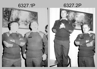
Photograph - Flag Day - Army Survey Regiment Verses School of Military Survey, Fortuna, Bendigo, c1984
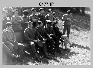
These 11 photographs were taken at Flag Day, an annual sports competition between the Army Survey Regiment and the School of Military Survey, at Bendigo circa 1984. The two RASvy units took turns each year to host the event. The day competition usually comprised basketball, cross country, golf, sailing, squash softball, tennis, touch football, tug-of-war and volleyball. The evening competition often included darts, carpet bowls, hookey, quoits and snooker. The flag handover and speeches suggests a victory for the Army Survey Regiment.This is a set of 11 photographs of Flag Day, Army Survey Regiment (ASR) verses the School of Military Survey (SMS), at Bendigo circa 1984. There are more photographs available on 35mm negatives and 35mm positive proofs. The photographs were printed on photographic paper and are part of the Army Survey Regiment’s Collection. The photographs were scanned at 300 dpi. .1) to .3) - Photo, black & white, c1984, L to R: SMS 2IC MAJ Paddy Strunks, ASR CO LTCOL Jorge Gruszka, .4) - Photo, black & white, c1984, L to R: ASR CO LTCOL Jorge Gruszka, SMS 2IC MAJ Paddy Strunks, SMS RSM WO1 Ken Slater. .5) - Photo, black & white, c1984, ASR RSM WO1 Bob Mason, ASR CO LTCOL Jorge Gruszka, SMS RSM WO1 Ken Slater, SMS 2IC MAJ Paddy Strunks. .6) & .7) - Photo, black & white, c1984, SPR Gayle Humphrey. .8) - Photo, black & white, c1984, L to R: unidentified, SGT Alan Staley (partially obscured), SPR Gai (Robinson) Amato. .9) - Photo, black & white, c1984, L to R: SPR Steve Ellis, unidentified (x2). .10) - Photo, black & white, c1984, L to R: SPR Bob Hopper, SPR Jan (Caithness) Lampton-Young, SPR Wally Twidale. .11) - Photo, black & white, c1984, L to R: unidentified, CPL Scheryl Delforce, unidentified, SPR Wally Twidale..1P to .11P – No annotationsroyal australian survey corps, rasvy, army survey regiment, army svy regt, fortuna, asr, flag day, school of military survey -
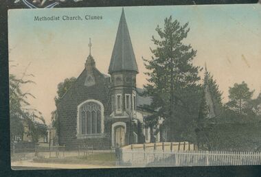 Uniting Church Archives - Synod of Victoria
Postcard, undated
The Wesleyan Methodist Church at Clunes is a distinctive bluestone building in the Gothic style and was designed by the Ballarat architect J.A. Doane. Construction began in 1864 and the church was further extended in 1871. The building consists of a broad nave and transepts with galleries, these having cast iron balustrades. The facade incorporates a slate-roofed octagonal turret and spire and a four-light perpendicular Gothic window. The interior includes windows with quarry glass panes and coloured borders; those on either side of the organ incorporate scrolled texts and may be by the Melbourne makers Ferguson & Urie. With declining congregations, the property was purchased by Wesley College in 1999 and now forms part of its Clunes campus. The church building has received a very extensive restoration, including structural strengthening, the opening out of the interior to its original dimensions and the installation of a new floor. Ref: https://www.ohta.org.au/organs/organs/ClunesUC.html Colour postcard showing a street view of the Clunes Methodist Church,clunes wesleyan methodist church, wesley college -
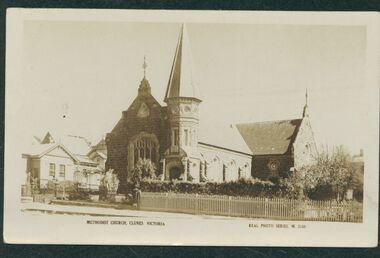 Uniting Church Archives - Synod of Victoria
Postcard, undated
The Wesleyan Methodist Church at Clunes is a distinctive bluestone building in the Gothic style and was designed by the Ballarat architect J.A. Doane. Construction began in 1864 and the church was further extended in 1871. The building consists of a broad nave and transepts with galleries, these having cast iron balustrades. The facade incorporates a slate-roofed octagonal turret and spire and a four-light perpendicular Gothic window. The interior includes windows with quarry glass panes and coloured borders; those on either side of the organ incorporate scrolled texts and may be by the Melbourne makers Ferguson & Urie. With declining congregations, the property was purchased by Wesley College in 1999 and now forms part of its Clunes campus. The church building has received a very extensive restoration, including structural strengthening, the opening out of the interior to its original dimensions and the installation of a new floor. Ref: https://www.ohta.org.au/organs/organs/ClunesUC.html Sepia postcard showing a street view of the Clunes Methodist Church,clunes wesleyan methodist church, wesley college -
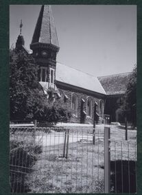 Uniting Church Archives - Synod of Victoria
Postcard - Photograph, January 2002
The Wesleyan Methodist Church at Clunes is a distinctive bluestone building in the Gothic style and was designed by the Ballarat architect J.A. Doane. Construction began in 1864 and the church was further extended in 1871. The building consists of a broad nave and transepts with galleries, these having cast iron balustrades. The facade incorporates a slate-roofed octagonal turret and spire and a four-light perpendicular Gothic window. The interior includes windows with quarry glass panes and coloured borders; those on either side of the organ incorporate scrolled texts and may be by the Melbourne makers Ferguson & Urie. With declining congregations, the property was purchased by Wesley College in 1999 and now forms part of its Clunes campus. The church building has received a very extensive restoration, including structural strengthening, the opening out of the interior to its original dimensions and the installation of a new floor. Ref: https://www.ohta.org.au/organs/organs/ClunesUC.html B & W exterior view of the Clunes Methodist Church, from the side.clunes wesleyan methodist church, wesley college -
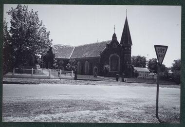 Uniting Church Archives - Synod of Victoria
Postcard - Photograph, January 2002
The Wesleyan Methodist Church at Clunes is a distinctive bluestone building in the Gothic style and was designed by the Ballarat architect J.A. Doane. Construction began in 1864 and the church was further extended in 1871. The building consists of a broad nave and transepts with galleries, these having cast iron balustrades. The facade incorporates a slate-roofed octagonal turret and spire and a four-light perpendicular Gothic window. The interior includes windows with quarry glass panes and coloured borders; those on either side of the organ incorporate scrolled texts and may be by the Melbourne makers Ferguson & Urie. With declining congregations, the property was purchased by Wesley College in 1999 and now forms part of its Clunes campus. The church building has received a very extensive restoration, including structural strengthening, the opening out of the interior to its original dimensions and the installation of a new floor. Ref: https://www.ohta.org.au/organs/organs/ClunesUC.html B & W exterior view of the Clunes Methodist Church.clunes wesleyan methodist church, wesley college -
 Uniting Church Archives - Synod of Victoria
Postcard - Photograph, 2002
The Wesleyan Methodist Church at Clunes is a distinctive bluestone building in the Gothic style and was designed by the Ballarat architect J.A. Doane. Construction began in 1864 and the church was further extended in 1871. The building consists of a broad nave and transepts with galleries, these having cast iron balustrades. The facade incorporates a slate-roofed octagonal turret and spire and a four-light perpendicular Gothic window. The interior includes windows with quarry glass panes and coloured borders; those on either side of the organ incorporate scrolled texts and may be by the Melbourne makers Ferguson & Urie. With declining congregations, the property was purchased by Wesley College in 1999 and now forms part of its Clunes campus. The church building has received a very extensive restoration, including structural strengthening, the opening out of the interior to its original dimensions and the installation of a new floor. Ref: https://www.ohta.org.au/organs/organs/ClunesUC.html B & W exterior view of the Clunes Wesley College development. The image shows school buildings on a block next to the former Clunes Methodist Church.clunes wesleyan methodist church, wesley college -
 Whitehorse Historical Society Inc.
Document, Pearce Family, 2001
... Slater ...Recollections of Ron Pearce about the Pearce familyRecollections of Ron Pearce about the Pearce family retailing and fruit growing activities in Blackburn in 1880 - 1930 period.Recollections of Ron Pearce about the Pearce family pearce, m, pearce, edward h, pearce, duncan spenser, slater, william, bayley, leonard sherwin, herb farms, pearce, ronald harry, orchards, blackburn, blackburn north, mall court, blackburn north, no 9. -
 Kew Historical Society Inc
Photograph - 'Mount Eri', 9 Highbury Grove, 1919
Subdivision plans are historically important documents used as evidence of the growth of suburbs in Australia. They frequently provide information about when the land was sold on which a built structure was subsequently constructed as well as evidence relating to surveyors and real estate and financial agents. The numerous subdivision plans in the Kew Historical Society's collection represent working documents, ranging from the initial sketches made in planning a subdivision to printed plans on which auctioneers or agents listed the prices for which individual lots were sold. In a number of cases, the reverse of a subdivision plan in the collection includes a photograph of a house that was also for sale by the agent. These photographs provide significant heritage information relating house design and decoration, fencing and household gardens.A photograph of Mount Eri, 9 Highbury Grove, an 11-room house for sale near the junction of Cotham and Glenferrie Roads. The substantial red brick, slate-roofed house and its location are not identified in the photograph, although the extent of the house is noted. It was described then as ‘well situated’ and close to 3 trams. Mathers, a financial agent in Cotham Road, placed advertisements about the sale of the property in The Argus in May and June 1919. The advertisement additionally refers to a billiard room and asserts that the house has every modern convenience. An annotation on the plan indicates that the house, with tennis court, was sold for £1960. Following extensive research, the house has now been conclusively identified, albeit extended and rendered. The house was originally built in the 19th century as a school and for much of the 20th century was used as a venue for receptions. -
 Kew Historical Society Inc
Photograph - 'Fernhurst', 13 Fernhurst Grove, 1978
George Wharton arrived in Melbourne in 1844. An architect and surveyor, he was appointed to lay out the 'Village of Kew' by N.A. Fenwick following the land sales of 1851. A protagonist for Kew's separation from the Boroondara District Road Board, he was elected chairman when Kew achieved municipal status in December 1860. His home, 'Fernhurst', was built in 1866 on eight acres in Studley Park, with a four-storey tower and pyramidal roof. The Italianate home was a prominent Kew landmark. It was demolished in 1979 and replaced by St Paul's College in 1980.Rare colour photograph of what was once a significant mansion in Kew.Original colour positive photograph (Kodak print) of 'Fernhurst' in 1978. Photographed by Stewart West in May 1978, one year before it was demolished, the photograph gives little idea of the large landholding once surrounding the house. Originally accessed from near the corner of Princess Street and Studley Park Road, its gardens had been subdivided in the 1900s and its footprint restricted to 13 Fernhurst Grove. Like many other grand houses, by the 1970s it had been converted into apartments. From the photograph, one can see that the house had retained many of its original features such as the distinctive tower and the wide bow-fronted verandah. The slates on the roof (apart from those on the tower) had been replaced by tiles and the cement render of the exterior painted white. Annotated reverse: "View of Fernhurst Home Taken from Street / 10"fernhurst, 13 fernhurst grove -- kew (vic.), george wharton, italianate architecture, vila maria society, st paul's school for the blind -
 Kew Historical Society Inc
Photograph - 'Fernhurst', 13 Fernhurst Grove, 1978
George Wharton arrived in Melbourne in 1844. An architect and surveyor, he was appointed to lay out the 'Village of Kew' by N.A. Fenwick following the land sales of 1851. A protagonist for Kew's separation from the Boroondara District Road Board, he was elected chairman when Kew achieved municipal status in December 1860. His home, 'Fernhurst', was built in 1866 on eight acres in Studley Park, with a four-storey tower and pyramidal roof. The Italianate home was a prominent Kew landmark. It was demolished in 1979 and replaced by St Paul's College in 1980.Rare colour photograph of what was once a significant mansion in Kew.Original colour positive photograph (Kodak print) of 'Fernhurst' in 1978. Photographed by Stewart West in May 1978, one year before it was demolished, the photograph gives little idea of the large landholding once surrounding the house. Originally accessed from near the corner of Princess Street and Studley Park Road, its gardens had been subdivided in the 1900s and its footprint restricted to 13 Fernhurst Grove. Like many other grand houses, by the 1970s it had been converted into apartments. From the photograph, one can see that the house had retained many of its original features such as the distinctive tower and the wide bow-fronted verandah. The slates on the roof (apart from those on the tower) had been replaced by tiles and the cement render of the exterior painted white. Annotated reverse: "Fernhurst from higher ground level side shot / 7"fernhurst, 13 fernhurst grove -- kew (vic.), george wharton, italianate architecture, vila maria society, st paul's school for the blind -
 Kew Historical Society Inc
Photograph - 'Fernhurst', 13 Fernhurst Grove, 1978
George Wharton arrived in Melbourne in 1844. An architect and surveyor, he was appointed to lay out the 'Village of Kew' by N.A. Fenwick following the land sales of 1851. A protagonist for Kew's separation from the Boroondara District Road Board, he was elected chairman when Kew achieved municipal status in December 1860. His home, 'Fernhurst', was built in 1866 on eight acres in Studley Park, with a four-storey tower and pyramidal roof. The Italianate home was a prominent Kew landmark. It was demolished in 1979 and replaced by St Paul's College in 1980.Rare colour photograph of what was once a significant mansion in Kew.Original colour positive photograph (Kodak print) of 'Fernhurst' in 1978. Photographed by Stewart West in May 1978, one year before it was demolished, the photograph gives little idea of the large landholding once surrounding the house. Originally accessed from near the corner of Princess Street and Studley Park Road, its gardens had been subdivided in the 1900s and its footprint restricted to 13 Fernhurst Grove. Like many other grand houses, by the 1970s it had been converted into apartments. From the photograph, one can see that the house had retained many of its original features such as the distinctive tower and the wide bow-fronted verandah. The slates on the roof (apart from those on the tower) had been replaced by tiles and the cement render of the exterior painted white. Annotated reverse: "Back view of Fernhurst / 8"fernhurst, 13 fernhurst grove -- kew (vic.), george wharton, italianate architecture, vila maria society, st paul's school for the blind -
 Kew Historical Society Inc
Photograph - 'Fernhurst', 13 Fernhurst Grove, 1978
George Wharton arrived in Melbourne in 1844. An architect and surveyor, he was appointed to lay out the 'Village of Kew' by N.A. Fenwick following the land sales of 1851. A protagonist for Kew's separation from the Boroondara District Road Board, he was elected chairman when Kew achieved municipal status in December 1860. His home, 'Fernhurst', was built in 1866 on eight acres in Studley Park, with a four-storey tower and pyramidal roof. The Italianate home was a prominent Kew landmark. It was demolished in 1979 and replaced by St Paul's College in 1980.Rare colour photograph of what was once a significant mansion in Kew.Original colour positive photograph (Kodak print) of 'Fernhurst' in 1978. Photographed by Stewart West in May 1978, one year before it was demolished, the photograph gives little idea of the large landholding once surrounding the house. Originally accessed from near the corner of Princess Street and Studley Park Road, its gardens had been subdivided in the 1900s and its footprint restricted to 13 Fernhurst Grove. Like many other grand houses, by the 1970s it had been converted into apartments. From the photograph, one can see that the house had retained many of its original features such as the distinctive tower and the wide bow-fronted verandah. The slates on the roof (apart from those on the tower) had been replaced by tiles and the cement render of the exterior painted white. Annotated reverse: "Fernhurst front view taken from across Fernhurst Grove / 6"fernhurst, 13 fernhurst grove -- kew (vic.), george wharton, italianate architecture, vila maria society, st paul's school for the blind -
 Kew Historical Society Inc
Photograph - 'Fernhurst', 13 Fernhurst Grove, 1978
George Wharton arrived in Melbourne in 1844. An architect and surveyor, he was appointed to lay out the 'Village of Kew' by N.A. Fenwick following the land sales of 1851. A protagonist for Kew's separation from the Boroondara District Road Board, he was elected chairman when Kew achieved municipal status in December 1860. His home, 'Fernhurst', was built in 1866 on eight acres in Studley Park, with a four-storey tower and pyramidal roof. The Italianate home was a prominent Kew landmark. It was demolished in 1979 and replaced by St Paul's College in 1980.Rare colour photograph of what was once a significant mansion in Kew.Original colour positive photograph (Kodak print) of 'Fernhurst' in 1978. Photographed by Stewart West in May 1978, one year before it was demolished, the photograph gives little idea of the large landholding once surrounding the house. Originally accessed from near the corner of Princess Street and Studley Park Road, its gardens had been subdivided in the 1900s and its footprint restricted to 13 Fernhurst Grove. Like many other grand houses, by the 1970s it had been converted into apartments. From the photograph, one can see that the house had retained many of its original features such as the distinctive tower and the wide bow-fronted verandah. The slates on the roof (apart from those on the tower) had been replaced by tiles and the cement render of the exterior painted white. Annotated reverse: "Front view of Fernhurst showing tower to advantage / 9"fernhurst, 13 fernhurst grove -- kew (vic.), george wharton, italianate architecture, vila maria society, st paul's school for the blind -
 Kew Historical Society Inc
Photograph - 'Fernhurst', 13 Fernhurst Grove, 1978
George Wharton arrived in Melbourne in 1844. An architect and surveyor, he was appointed to lay out the 'Village of Kew' by N.A. Fenwick following the land sales of 1851. A protagonist for Kew's separation from the Boroondara District Road Board, he was elected chairman when Kew achieved municipal status in December 1860. His home, 'Fernhurst', was built in 1866 on eight acres in Studley Park, with a four-storey tower and pyramidal roof. The Italianate home was a prominent Kew landmark. It was demolished in 1979 and replaced by St Paul's College in 1980.Rare colour photograph of what was once a significant mansion in Kew.Original colour positive photograph (Kodak print) of 'Fernhurst' in 1978. Photographed by Stewart West in May 1978, one year before it was demolished, the photograph gives little idea of the large landholding once surrounding the house. Originally accessed from near the corner of Princess Street and Studley Park Road, its gardens had been subdivided in the 1900s and its footprint restricted to 13 Fernhurst Grove. Like many other grand houses, by the 1970s it had been converted into apartments. From the photograph, one can see that the house had retained many of its original features such as the distinctive tower and the wide bow-fronted verandah. The slates on the roof (apart from those on the tower) had been replaced by tiles and the cement render of the exterior painted white. Annotated reverse: "Fernhurst corner shot through trees / 12-22"fernhurst, 13 fernhurst grove -- kew (vic.), george wharton, italianate architecture, vila maria society, st paul's school for the blind -
 Bendigo Military Museum
Photograph - WO1 Darby Munro Farewell, Army Survey Regiment, Fortuna, Bendigo, c1978
This is a set of four photographs featuring WO1 Darby Munro being farewelled by CAPT Gary Kenney and members of Lithographic Squadron at Fortuna, Bendigo in circa 1978. WO1 Munro served in the Australian Army from 1956 to 1986. This was probably his last day at Fortuna before the next posting in his career.This is a set of four photographs featuring WO1 Darby Munro being farewelled by members of Lithographic Squadron at Fortuna, Bendigo in circa 1978. The photographs are on 35mm negative film and were scanned at 96 dpi. They are part of the Army Survey Regiment’s Collection. .1) - Photo, black & white, c1978. Back row L to R: unidentified, SPR Mick ‘Buddha’ Ellis, SPR John Bateman, SPR Martin Van De Maele, SPR Peter Imeson, unidentified, CPL Warren ‘Waldo’ Shirley. Front row L to R: LT Struan Robertson, CAPT Terry Edwards, WO1 Darby Munro, WO2 Ken Slater, PTE Di Chalmers. .2) to .4) - Photo, black & white, c1978. L to R: CAPT Gary Kenney, WO1 Darby Munro.No personnel are identified.royal australian survey corps, rasvy, army survey regiment, army svy regt, fortuna, asr, litho sqn -
 Bacchus Marsh & District Historical Society
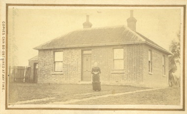
Photograph, James Reid House Bacchus Marsh 1883
James Reid was born in Scotland near Glasgow and came to Victoria as a young man in 1854. Shortly after arriving he came to Bacchus Marsh where he lived until his death in 1902 at the age of 74 years. For most of these years he conducted a wheelwrights and coach builders business in Bacchus Marsh. In the nineteenth and early twentieth centuries, wheelwrights and blacksmiths played an essential role in the functioning of the whole community. Before the industrialisation of manufacturing, wheels and other components of vehicles for transport, all metal objects, including farm implements, building requirements and domestic utensils were made by hand. As mechanisation of industry increased, the smith commonly performed the role of farrier in the times when horse power was pivotal to all aspects of society. Small sepia unframed photograph on card with gold border framing photograph. Housed in the album, 'Photographs of Bacchus Marsh and District in 1883 by Stevenson and McNicoll' The photo shows a plain brick house with a central front door with a window on either side. There are a further two windows along the side of the house. On the left-hand side of the building there is a smaller room with its own entry door. The main roof is tiled with shingles or slate and features two substantial chimneys. At the front of the house stands a young woman with her hands clasped. A horse can be seen at the rear of the house. From the photo of the James Reid Wheelwright and Blacksmith Shop, Victorian Collections No.VC 618, we know that this house stood to the rear of the workshop. The wheel tracks which can be seen lead out to Main Street. On the front: Stevenson & McNicoll. Photo. 108 Elizabeth St. Melbourne. COPIES CAN BE OBTAINED AT ANY TIME. On the back: LIGHT & TRUTH inscribed on a banner surmounted by a representation of the rising sun. Copies of this Portrait can be had at any time by sending the Name and Post Office Money Order or Stamps for the amount of order to STEVENSON & McNICOLL LATE BENSON & STEVENSON, Photographers. 108 Elizabeth Street, MELBOURNE houses bacchus marsh, stevenson and mcnicoll 1883 photographs of bacchus marsh and district, james reid 1828?-1902, wheelrights bacchus marsh -
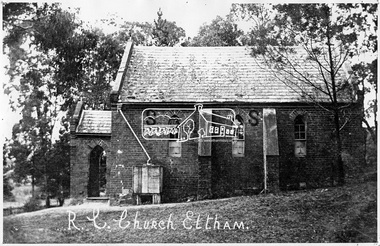 Eltham District Historical Society Inc
Negative - Photograph, Tom Prior, St Mary's Roman Catholic Church, Eltham, c.1900
The original St Mary’s Roman Catholic Church (1865-1912) was built of clay brick with buttress walls and a slate roof on the corner of Fordhams Road and Maria Street (Main Road), Eltham South, opposite the present-day Wingrove Park. It was blessed on September 3, 1865. With the arrival of the railway in 1901 and the town centre moving closer to the station, the decision was made to relocate the site of the church to its present-day location on Henry Street at the corner of Main Road. A new timber weatherboard church, also called St Mary's was erected and blessed on October 13, 1912. The church and land cost £1,400 (Evelyn Observer). The original brick church It was demolished in the 1920s and the bricks and windows were recycled to build a dairy on the Brinkkotter farm at Research. The timber church was destroyed by fire in 1961 and a new modern architectural (1960s) style church was erected in its place and named Our Lady of Help Christians Church.This photo forms part of a collection of photographs gathered by the Shire of Eltham for their centenary project book,"Pioneers and Painters: 100 years of the Shire of Eltham" by Alan Marshall (1971). The collection of over 500 images is held in partnership between Eltham District Historical Society and Yarra Plenty Regional Library (Eltham Library) and is now formally known as the 'The Shire of Eltham Pioneers Photograph Collection.' It is significant in being the first community sourced collection representing the places and people of the Shire's first one hundred years. The Reynolds family were early settlers in Research. The Reynolds/ Prior collection of photographs were taken by Tom Prior, the maternal uncle of Ivy Reynolds, around 1900 and the 60 photos in the album give a fine overview of many of the landmarks of Research and Eltham over 100 years ago. lvy lived in the family home for many years at 106 Thompson Cres Research. Ivy's father, Ernst Richard Reynolds and grandfather, Richard Reynolds, lived at the same address. Ivy's father Richard worked for Mr. Trail on his property in Research. Reynolds Road is named after the family. Mr Tom Prior (wife Eva) worked at the Melbourne zoo. He was very innovative and made his own camera, using the black cloth hood to exclude the light. The photographs are a reminder of the rural nature of Research and Eltham and its rich heritage.Digital image 4 x 5 inch B&W Negsepp, shire of eltham pioneers photograph collection, eltham, roman catholic church, brinkkotter, catholic church, church, reynolds prior collection, st marys catholic church -
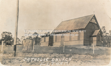 Eltham District Historical Society Inc
Postcard - Photograph, St Mary's Catholic Church, cnr Main Road and Henry Street, Eltham, c.1912
The original St Mary’s Roman Catholic Church (1865-1912) was built of clay brick with buttress walls and a slate roof on the corner of Fordhams Road and Maria Street (Main Road), Eltham South, opposite the present-day Wingrove Park. It was blessed on September 3, 1865. With the arrival of the railway in 1901 and the town centre moving closer to the station, the decision was made to relocate the site of the church to its present-day location on Henry Street at the corner of Main Road. A new timber weatherboard church, also called St Mary's was erected and blessed on October 13, 1912. The church and land cost £1,400 (Evelyn Observer). The original brick church It was demolished in the 1920s and the bricks and windows were recycled to build a dairy on the Brinkkotter farm at Research. The timber church was destroyed by fire in 1961 and a new modern architectural (1960s) style church was erected in its place and named Our Lady of Help Christians Church.PostcardReturn to Garnet Burges, Judge Bookchurches, catholic churches, st marys, main road, henry street, eltham -
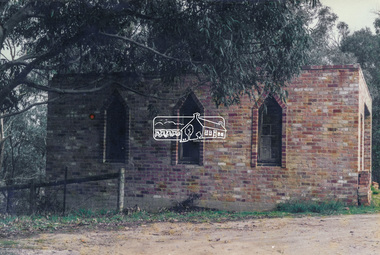 Eltham District Historical Society Inc
Photograph, Old dairy on the Brinkkotter farm, Research, Vic, Jul. 2001
The original St Mary’s Roman Catholic Church (1865-1912) was built of clay brick with buttress walls and a slate roof on the corner of Fordhams Road and Maria Street (Main Road), Eltham South, opposite the present-day Wingrove Park. It was blessed on September 3, 1865. With the arrival of the railway in 1901 and the town centre moving closer to the station, the decision was made to relocate the site of the church to its present-day location on Henry Street at the corner of Main Road. A new timber weatherboard church, also called St Mary's was erected and blessed on October 13, 1912. The church and land cost £1,400 (Evelyn Observer). The original brick church was demolished in the 1920s and the bricks and windows were recycled to build a dairy on the Brinkkotter farm at Research. The timber church was destroyed by fire in 1961 and a new modern architectural (1960s) style church was erected in its place and named Our Lady of Help Christians Church.Colour photographresearch (vic.), brinkkotter, catholic church, eltham, roman catholic church, st marys catholic church -
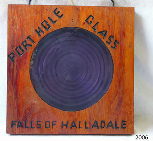 Flagstaff Hill Maritime Museum and Village
Glass
Falls of Halladale The Falls of Halladale was a four-masted sailing ship built-in 1886 in Glasgow, Scotland, for the long-distance cargo trade and was mostly used for Pacific grain trade. She had a sturdy construction built to carry maximum cargo and able to maintain full sail in heavy gales, one of the last of the ‘windjammers’ that sailed the Trade Route. She was one of the first vessels to include fore and aft lifting bridges, which kept the crew safe and dry in as they moved around the decks in stormy conditions. She was owned by Wright, Breakenridge & Co of Glasgow and was one of several Falls Line ships, all of which were named after waterfalls in Scotland. On 4th August 1908, with new sails, 29 crew, and 2800 tons of cargo, the Falls of Halladale left New York, bound for Melbourne and Sydney via the Cape of Good Hope. The cargo on board was valued at £35,000 and included 56,763 tiles of American slate roofing tiles, 5,673 coils of barbed wire, 600 stoves, 500 sewing machines, 6,500 gallons of oil, 14,400 gallons of benzene, plumbing iron, 117 cases of crockery and glassware and many other manufactured items. The Falls of Halladale had been at sail for 102 days when, at 3 am on the of 14th November 1908, under full sail in calm seas with a six knots breeze behind and misleading fog along the coast, the great vessel rose upon an ocean swell and settled on top of a submerged reef near Peterborough on south-west Victoria’s coast. The ship was jammed on the rocks and began filling with water. The crew launched the two lifeboats and all 29 crew landed safely on the beach over 4 miles away at the Bay of Islands. The postmistress at Peterborough, who kept a watch for vessels in distress, saw the stranding and sent out an alert to the local people. A rescue party went to the aid of the sailors and the Port Campbell rocket crew was dispatched, but the crew had all managed to reach shore safely by the time help arrived. The ship stayed in full sail on the rocky shelf for nearly two months, attracting hundreds of sightseers who watched her slowly disintegrate until the pounding seas and dynamiting by salvagers finally broke her back, and her remains disappeared back into deeper water. The valuable cargo was largely lost, despite two salvage attempts in 1908-09 and 1910. Further salvage operations were made from 1974-1986, during which time 22,000 slate tiles were recovered with the help of 14 oil drums to float them, plus personal artefacts, ship fittings, reams of paper and other items (a list of items held at Flagstaff Hill Maritime Village is included below). The Court of Marine Inquiry in Melbourne ruled that the foundering of the ship was entirely due to Captain David Wood Thomson’s navigational error, not too technical failure of the Clyde-built ship. The shipwreck is a popular site for divers, about 300m offshore and in 3 – 15m of water. Some of the original cargo can be seen at the site, including pieces of roof slate and coils of barbed wire. The Falls of Halladale shipwreck is listed on the Victorian Heritage Register (No. S255). She was one of the last ships to sail the Trade Routes. She is one of the first vessels to have fore and aft lifting bridges. She is an example of the remains of an International Cargo Ship and also represents aspects of Victoria’s shipping industry. The wreck is protected as a Historic Shipwreck under the Commonwealth Historic Shipwrecks Act (1976).Porthole glass secured in wood, with a crack in the glass. Writing on wood "porthole Glass Falls of Halladale."Burnt into the wood are the words "porthole Glass Falls of Halladale."falls of halladale, wright, breakenridge & co of glasgow, californian blue roof slate, warrnambool, shipwrecked-coast, flagstaff-hill, flagstaff-hill-maritime-museum, maritime-museum, shipwreck-coast, flagstaff-hill-maritime-village, shipwrecked-artefact, porthole glass -
 Flagstaff Hill Maritime Museum and Village
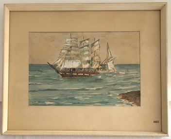
Painting - Watercolour painting, Early 20th century
FALLS of HALLADALE - History The Falls of Halladale was a four-masted sailing ship built-in 1886 in Glasgow, Scotland, for the long-distance cargo trade and was mostly used for Pacific grain trade. She had a sturdy construction, built to carry maximum cargo and maintain full sail in heavy gales. She was one of the last of the ‘windjammers’ that sailed the Trade Route and one of the first vessels to include fore and aft lifting bridges, which kept the crew safe and dry in as they moved around the decks in stormy conditions. She was owned by Wright, Breakenridge & Co of Glasgow and was one of several Falls Line ships, all of which were named after waterfalls in Scotland. On 4th August 1908, with new sails, 29 crew, and 2800 tons of cargo, the Falls of Halladale left New York, bound for Melbourne and Sydney via the Cape of Good Hope. The cargo on board was valued at £35,000 and included 56,763 tiles of American slate roofing tiles, 5,673 coils of barbed wire, 600 stoves, 500 sewing machines, 6,500 gallons of oil, 14,400 gallons of benzene, plumbing iron, 117 cases of crockery and glassware and many other manufactured items. The Falls of Halladale had been at sail for 102 days when, at 3 am on the of 14th November 1908, under full sail in calm seas with a six knots breeze behind and misleading fog along the coast, the great vessel rose upon an ocean swell and settled on top of a submerged reef near Peterborough on south-west Victoria’s coast. The ship was jammed on the rocks and began filling with water. The crew launched the two lifeboats and all 29 crew landed safely on the beach over 4 miles away at the Bay of Islands. The postmistress at Peterborough, who kept a watch for vessels in distress, saw the stranding and sent out an alert to the local people. A rescue party went to the aid of the sailors and the Port Campbell rocket crew was dispatched, but the crew had all managed to reach shore safely by the time help arrived. The ship stayed in full sail on the rocky shelf for nearly two months, attracting hundreds of sightseers who watched her slowly disintegrate until the pounding seas and dynamiting by salvagers finally broke her back, and her remains disappeared back into deeper water. The valuable cargo was largely lost, despite two salvage attempts in 1908-09 and 1910. Further salvage operations were made from 1974-1986, during which time 22,000 slate tiles were recovered with the help of 14 oil drums to float them, plus personal artefacts, ship fittings, reams of paper and other items (a list of items held at Flagstaff Hill Maritime Village is included below). The Court of Marine Inquiry in Melbourne ruled that the foundering of the ship was entirely due to Captain David Wood Thomson’s navigational error, not to technical failure of the Clyde-built ship. The shipwreck is a popular site for divers, about 300m offshore and in 3 – 15m of water. Some of the original cargo can be seen at the site, including pieces of roof slate and coils of barbed wire.The Falls of Halladale shipwreck is listed on the Victorian Heritage Register (No. S255). She was one of the last ships to sail the Trade Routes. She is one of the first vessels to have fore and aft lifting bridges. She is an example of the remains of an International Cargo Ship and also represents aspects of Victoria’s shipping industry. The wreck is protected as a Historic Shipwreck under the Commonwealth Historic Shipwrecks Act (1976).Watercolour painting behind glass, framed in the Art Deco style - stippled cream painted wood. There are some age marks under the glass. The painting depicts the Falls of Halladale with its stern under water. The back of the painting contains facts about the shipwreck handwritten in a similar style to the artist’s signature. The artist’s signature is not clear enough to identify. Inscription on the back: Pasted on typed text: Peterborough Handwriting: Falls of Halladale 2085 tons 4 masted iron barque wrecked Saturday November 14th 1908 Captain Thomson crew of 28 !st mate F Pearson 2nd mate T Griffinflagstaff hill, warrnambool, flagstaff hill maritime museum & village, maritime museum, maritime village, shipwreck coast, 1908 shipwreck, falls of halladale, peterborough, peterborough shipwreck, great ocean road, captain thomson, 1880s sailing ship, cargo vessel, 1st mate f pearson, 2nd mate t griffin, watercolour painting -
 Flagstaff Hill Maritime Museum and Village
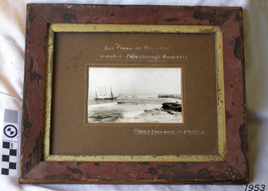
Photograph - Vessel, Sailing Ship, Falls of Halladale, After 13-11-1908
Falls of Halladale The Falls of Halladale was a four-masted sailing ship built-in 1886 in Glasgow, Scotland, for the long-distance cargo trade and was mostly used for Pacific grain trade. She had a sturdy construction built to carry maximum cargo and able to maintain full sail in heavy gales, one of the last of the ‘windjammers’ that sailed the Trade Route. She was one of the first vessels to include fore and aft lifting bridges, which kept the crew safe and dry in as they moved around the decks in stormy conditions. She was owned by Wright, Breakenridge & Co of Glasgow and was one of several Falls Line ships, all of which were named after waterfalls in Scotland. On 4th August 1908, with new sails, 29 crew, and 2800 tons of cargo, the Falls of Halladale left New York, bound for Melbourne and Sydney via the Cape of Good Hope. The cargo on board was valued at £35,000 and included 56,763 tiles of American slate roofing tiles, 5,673 coils of barbed wire, 600 stoves, 500 sewing machines, 6,500 gallons of oil, 14,400 gallons of benzene, plumbing iron, 117 cases of crockery and glassware and many other manufactured items. The Falls of Halladale had been at sail for 102 days when, at 3 am on the of 14th November 1908, under full sail in calm seas with a six knots breeze behind and misleading fog along the coast, the great vessel rose upon an ocean swell and settled on top of a submerged reef near Peterborough on south-west Victoria’s coast. The ship was jammed on the rocks and began filling with water. The crew launched the two lifeboats and all 29 crew landed safely on the beach over 4 miles away at the Bay of Islands. The postmistress at Peterborough, who kept a watch for vessels in distress, saw the stranding and sent out an alert to the local people. A rescue party went to the aid of the sailors and the Port Campbell rocket crew was dispatched, but the crew had all managed to reach shore safely by the time help arrived. The ship stayed in full sail on the rocky shelf for nearly two months, attracting hundreds of sightseers who watched her slowly disintegrate until the pounding seas and dynamiting by salvagers finally broke her back, and her remains disappeared back into deeper water. The valuable cargo was largely lost, despite two salvage attempts in 1908-09 and 1910. Further salvage operations were made from 1974-1986, during which time 22,000 slate tiles were recovered with the help of 14 oil drums to float them, plus personal artefacts, ship fittings, reams of paper and other items (a list of items held at Flagstaff Hill Maritime Village is included below). The Court of Marine Inquiry in Melbourne ruled that the foundering of the ship was entirely due to Captain David Wood Thomson’s navigational error, not too technical failure of the Clyde-built ship. The shipwreck is a popular site for divers, about 300m offshore and in 3 – 15m of water. Some of the original cargo can be seen at the site, including pieces of roof slate and coils of barbed wire. The Falls of Halladale shipwreck is listed on the Victorian Heritage Register (No. S255). She was one of the last ships to sail the Trade Routes. She is one of the first vessels to have fore and aft lifting bridges. She is an example of the remains of an International Cargo Ship and also represents aspects of Victoria’s shipping industry. The wreck is protected as a Historic Shipwreck under the Commonwealth Historic Shipwrecks Act (1976).Photograph of the wrecked ship, the Falls of Halladale, sails still flying. The ship was wrecked at Peterborough on Nov 13, 1908. The outer frame is made from a piece of planking. Handwritten inscriptions in white ink on the top of the matt board, and on the lower right.BQE "Falls of Halladale" "Wrecked. Peterborough. Nov 13. 1908" "Frame. from piece of planking."flagstaff hill, warrnambool, shipwrecked-coast, flagstaff-hill, flagstaff-hill-maritime-museum, maritime-museum, shipwreck-coast, flagstaff-hill-maritime-village, shipwreck, photograph, falls of halladale, planking frame