Showing 652 items
matching survey department
-
 Bendigo Historical Society Inc.
Map - JACK FLYNN COLLECTION: BONN, 16/07/1919
... . Photo Lithographed at the Department of Lands and Survey.... Government Printer, Melbourne. Photo Lithographed at the Department ...Map: Parish of Bonn, County of Rodney. Parish plan.By Authority A. J. Mullett. Government Printer, Melbourne. Photo Lithographed at the Department of Lands and Survey. Melbourne by W. J. Butson.map, rodney, parish plan, bonn, rodney -
 Bendigo Historical Society Inc.
Map - JACK FLYNN COLLECTION: VILLAGE OF BETLEY, 30/06/1874
... Photo Lithographed at the Department of Lands and Survey... at the Department of Lands and Survey Melbourne by J. Noone 30.6.74 Map ...Map: Village of Betley, on the Bet Bet Creek, Parish of Dunolly. Parish plan.Photo Lithographed at the Department of Lands and Survey Melbourne by J. Noone 30.6.74map, gladstone, village, betley, bet bet creek, dunolly -
 Bendigo Historical Society Inc.
Map - JACK FLYNN COLLECTION: BAMAWM, 19/08/1924
... Photo Lithographed at the Department of Lands and Survey... Bendigo parish plan Bamawm Photo Lithographed at the Department ...Map: Parish of Bamawm, County of Bendigo. Parish plan.Photo Lithographed at the Department of Lands and Survey, Melbourne by W.J. Butson. 19.8.24map, bendigo, parish plan, bamawm -
 Bendigo Historical Society Inc.
Map - JACK FLYNN COLLECTION: COHUNA, 1963
... . Drawn and Reproduced at the Department of Lands and Survey... at the Department of Lands and Survey, Melbourne.1963. Map: Photocopy ...Map: Photocopy of parish plan showing Cohuna and a portion of the Gunbower Creek.By Authority. A.C. Brooks Government Printer, Melbourne. Drawn and Reproduced at the Department of Lands and Survey, Melbourne.1963.map, gunbower, parish plan, cohuna , gunbower creek -
 Bendigo Historical Society Inc.
Map - JACK FLYNN COLLECTION: BET BET, 18/08/1931
... at the Department of Lands and Survey, Melbourne. 18.8.31... at the Department of Lands and Survey, Melbourne. 18.8.31 Map: Parish of Bet ...Map: Parish of Bet Bet, Counties of Gladstone and Talbot . Parish plan.By Authority H.J. Green Govt, Printer. Photo Lithographed at the Department of Lands and Survey, Melbourne. 18.8.31map, gladstone, parish plan, bet bet, counties of gladstone and talbot. -
 Bendigo Historical Society Inc.
Map - JACK FLYNN COLLECTION: KARA KARA, 1932
... . Department of Lands and Survey, Melbourne, 1958..., Government Printer Melbourne. Department of Lands and Survey ...Map: County of Kara Kara, map sheet showing the whole of the County of Kara Kara and all of the Parishes within. Scale 2 miles to 1 inch.By Authority: W.M. Houston, Government Printer Melbourne. Department of Lands and Survey, Melbourne, 1958map, kara kara, county, kara kara -
 Bendigo Historical Society Inc.
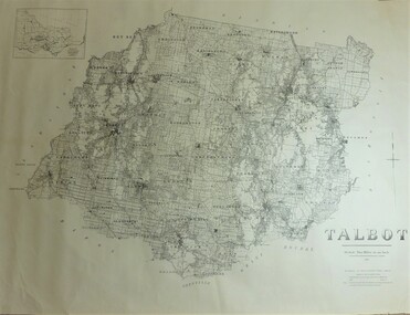
Map - JACK FLYNN COLLECTION: TALBOT, 1937
... . Department of Lands and Survey Melbourne. 1959... Printer, Melbourne. Department of Lands and Survey Melbourne. 1959 ...Map: County of Talbot, map sheet showing the whole of the County of Talbot and all of the Parishes within. Scale 2 Miles to 1 inch.By Authority: A.C. Brooks, Government Printer, Melbourne. Department of Lands and Survey Melbourne. 1959map, talbot, county, talbot -
 Bendigo Historical Society Inc.
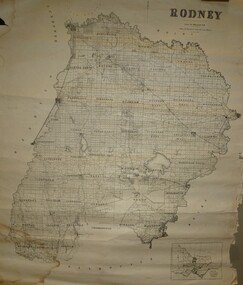
Map - JACK FLYNN COLLECTION: RODNEY, Revised in 1935
... Drawn at the Department of Lands and Survey, Melbourne... Rodney parish plan Rodney Drawn at the Department of Lands ...Map: County of Rodney, map sheet showing the whole of the County of Rodney and all of the Parishes within.Drawn at the Department of Lands and Survey, Melbourne. Revised to 1935map, rodney, parish plan, rodney -
 Bendigo Historical Society Inc.
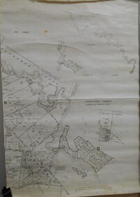
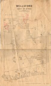
Map - JACK FLYNN COLLECTION: WELLSFORD, 2/11/1914
... Photo-Lithographed at the Department of Lands and Survey... Bendigo parish plan Wellsford Photo-Lithographed at the Department ...Map: Parish of Wellsford, County of Bendigo. Parish plan.Photo-Lithographed at the Department of Lands and Survey Melbourne By H.J. Butson. 2-.11.14map, bendigo, parish plan, wellsford -
 Bendigo Historical Society Inc.
Map - JACK FLYNN COLLECTION: COUNTY OF GLADSTONE, 1934
... Engraved at the Department of Lands and Survey Melbourne... Gladstone parish plan Gladstone Engraved at the Department of Lands ...Map: County of Gladstone, map sheet showing the whole of the County and the Parishes within. Scale 2 Miles to 1 inch.Engraved at the Department of Lands and Survey Melbourne. 1958. By Authority of W.M. Houston, Government Printermap, gladstone, parish plan, gladstone -
 Bendigo Historical Society Inc.
Map - JACK FLYNN COLLECTION: YARRAYNE, 6/01/1932
... -Lithographed at the Department of Lands and Survey, Melbourne. 5.1.32....., Printer. Photo-Lithographed at the Department of Lands and Survey ...Map: Parish of Yarrayne, County of Bendigo. Parish plan.By Authority, H.J. Green, Govt., Printer. Photo-Lithographed at the Department of Lands and Survey, Melbourne. 5.1.32.map, bendigo, parish plan, yarrayne -
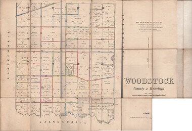 Bendigo Historical Society Inc.
Map - JACK FLYNN COLLECTION: WOODSTOCK, 27/03/75
... Photo-Lithographed at the Department of Lands and Survey... Bendigo parish plan Woodstock Photo-Lithographed at the Department ...Map: Parish of Woodstock , County of Bendigo. Parish plan.Photo-Lithographed at the Department of Lands and Survey Melbourne by J. Noone. 27.3.79map, bendigo, parish plan, woodstock -
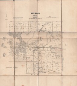 Bendigo Historical Society Inc.
Map - JACK FLYNN COLLECTION: WARANGA, 1959
... . Drawn and Reproduced at the Department of lands and survey... Printer Melbourne. Drawn and Reproduced at the Department of lands ...Map: Parish of Waranga, County of Rodney. Parish plan.By Authority. A.C. Brooks. Government Printer Melbourne. Drawn and Reproduced at the Department of lands and survey. Melbourne 1959.map, rodney, parish plan, waranga -
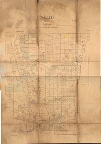 Bendigo Historical Society Inc.
Map - JACK FLYNN COLLECTION: TOOLLEEN, 25/05.1926
... -Lithographed at the Department of Lands and Survey Melbourne. W. J...., Printer. Photo-Lithographed at the Department of Lands and Survey ...Map: Parish of Toolleen, County of Rodney. Parish plan.By Authority, H.J. Green. Govt., Printer. Photo-Lithographed at the Department of Lands and Survey Melbourne. W. J. Butson 25.5.26.map, rodney, parish plan, toolleen -
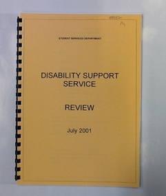 NMIT (Northern Melbourne Institute of TAFE)
Report - NMIT, NMIT. Student Services Department, Disability Support Service. Review 2001, 2001
This document reviews approximately 5 years of disability support service at NMIT campuses. It includes survey results and organisation of the department.48 pages of text. Yellow title page with clear plastic cover, spiral bound.disability support service, equal opportunity, nmit, -
 Bendigo Historical Society Inc.
Map - MAP PORTION OF BENDIGO GOLDFIELD, Circa 1912
Map: Portion of Bendigo Goldfield showing Sheepshead, Deborah, Garden Gully, Paddy's Gully and Derby lines of reef. Showing statistical records of all the Companies on these lines. Issued by Wood and McNair, Sharebrokers, Bendigo and Eaglehawk. The map illustrates the main lines of reef as they appeared with mines and details of their calls and dividends as well as gold produced. Drawn by mining surveyor and geologist William Henry Cundy, who trained and worked for the Tasmanian Mines Department until 1893, when he moved and settled in Bendigo. Cundy was responsible for the surveying of the southern end of the field of Diamond Hill and beyond.topic, mining, companies, bendigo goldfield, sheepshead , deborah, garden gully, paddy's gully derby, wood and mcnair -
Bendigo Historical Society Inc.
Map - VICTORIA, Circa 1926
... and Geographic features. Compiled and engraved at the Department of Lands.... Compiled and engraved at the Department of Lands and Survey ...Map: Map showing Counties, including Railway lines and Geographic features. Compiled and engraved at the Department of Lands and Survey Melbourne, Revised October 1926 ( number 184 in Map Cupboard 1)map, victoria, counties, counties of victoria, geographic features -
 Bendigo Historical Society Inc.
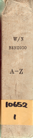
Document - DEPARTMENT OF LANDS AND SURVEY: WIRE NETTING ADVANCE REGISTER BENDIGO REGION
... DEPARTMENT OF LANDS AND SURVEY: WIRE NETTING ADVANCE...Department of Lands and Survey...Department of Lands and Survey Wire Netting Advance... ORGANISATION Government Department of Lands and Survey Department ...Department of Lands and Survey Wire Netting Advance register, Bendigo region. Large hard cover book with yellow card pages, representing individual properties in the Bendigo area. Written on spine of book: "W/Bendigo, A-Z, 10652,1" Dates in book from 1929 - 1939.organisation, government, department of lands and survey -
Moorabbin Air Museum
Document (Item) - Field Service Survey Hercules Neptune Navy Jindivik And Operating Instructions Neptune Fire Extingui
Description: Comb bound 20 pages Department of Supply Government Aircraft Factories GAF Level of Importance: National. -
Moorabbin Air Museum
Document (Item) - Field Service Survey Macchi 000-318
Description: Macchi Defects Macchi MB326H Service Department reports RAAF various locations Level of Importance: World. -
Moorabbin Air Museum
Document (Item) - Macchi Field Service Survey Reports M510
Description: Macchi Defects reports Service Department CAC Level of Importance: . -
Moorabbin Air Museum
Document (Item) - Field Service Survey Macchi 520 To 533
Description: Macchi Defect reports Service department RAAF Level of Importance: . Historical Details: 18/9/69 to 1/4/74 -
Moorabbin Air Museum
Document (Item) - Macchi Field Service Survey 580 To
Description: Macchi Defect reports Service Department RAAF Level of Importance: . -
 St Kilda Historical Society
Photograph - Photo map, 28/01/1951
One of a series of photo-maps produced for the Department of Crown Lands and Survey (1857-1983). For correlation with a current map, and access to other historical photo maps of Victoria, see the Historic Photo-Maps Index published by the Department of Environment, Land, Water and Planning at https://services.land.vic.gov.au/DELWPmaps/historical-photomaps/Black and white aerial photograph1424-45 SECRET 534 Run 18 Lens 12" Melbourne Metropolitan 12150 28.1.51 M639albert park, st kilda junction, st kilda pier, catani gardens, st kilda, prahran, albert park lake, 1951, middle park, st kilda beach, windsor -
 St Kilda Historical Society
Photograph - Photo map, 17/01/1951
One of a series of photo-maps produced for the Department of Crown Lands and Survey (1857-1983). For correlation with a current map, and access to other historical photo maps of Victoria, see the Historic Photo-Maps Index published by the Department of Environment, Land, Water and Planning at https://services.land.vic.gov.au/DELWPmaps/historical-photomaps/Black and white aerial photograph1414-21 538 Run 19 Lens 12" Melbourne Metropolitan 12150 17.1.51 M586st kilda, st kilda botanical gardens, peanut farm, elwood, 1951, point ormond, elwood canal, st kilda beach -
 St Kilda Historical Society
Photograph - Photo map, 28/01/1951
One of a series of photo-maps produced for the Department of Crown Lands and Survey (1857-1983). For correlation with a current map, and access to other historical photo maps of Victoria, see the Historic Photo-Maps Index published by the Department of Environment, Land, Water and Planning at https://services.land.vic.gov.au/DELWPmaps/historical-photomaps/Black and white aerial photograph1424-118 534 Run 20 Lens 12" Melbourne Metropolitan 12150 18.1.51M639elwood, point ormond, elwood park, elsternwick park, elwood beach, 1951 -
 St Kilda Historical Society
Photograph - Photo map, 17/01/1951
One of a series of photo-maps produced for the Department of Crown Lands and Survey (1857-1983). For correlation with a current map, and access to other historical photo maps of Victoria, see the Historic Photo-Maps Index published by the Department of Environment, Land, Water and Planning at https://services.land.vic.gov.au/DELWPmaps/historical-photomaps/Black and white aerial photograph1414-20 538 Run 19 Lens 12" Melbourne Metropolitan 12150 17.1.51 M586elwood, elsternwick, st kilda east, balaclava, ripponlea, 1951 -
 St Kilda Historical Society
Photograph - Photo map, 28/01/1951
One of a series of photo-maps produced for the Department of Crown Lands and Survey (1857-1983). For correlation with a current map, and access to other historical photo maps of Victoria, see the Historic Photo-Maps Index published by the Department of Environment, Land, Water and Planning at https://services.land.vic.gov.au/DELWPmaps/historical-photomaps/Black and white aerial photograph1424-44 534 Run 18 Lens 12" Melbourne Metropolitan 12150 28.1.51 M639 -
 St Kilda Historical Society
Photograph - Photo map, 28/01/1951
One of a series of photo-maps produced for the Department of Crown Lands and Survey (1857-1983). For correlation with a current map, and access to other historical photo maps of Victoria, see the Historic Photo-Maps Index published by the Department of Environment, Land, Water and Planning at https://services.land.vic.gov.au/DELWPmaps/historical-photomaps/Black and white aerial photograph1424-43 534 Run 18 Lens 12" Melbourne Metropolitan 12150 28.1.51 M639armadale, malvern, st kilda cemetery, caulfield north, st kilda east, 1951 -
 St Kilda Historical Society
Photograph - Photo map, 30/01/1960
One of a series of photo-maps produced for the Department of Crown Lands and Survey (1857-1983). For correlation with a current map, and access to other historical photo maps of Victoria, see the Historic Photo-Maps Index published by the Department of Environment, Land, Water and Planning at https://services.land.vic.gov.au/DELWPmaps/historical-photomaps/Black and white aerial photographVic 1093-62 Melbourne & Metropolitan Project Run 21 30.1.60 Lens 10" 8.200middle park, albert park, catani gardens, st kilda west, 1960