Showing 771 items
matching the white farm
-
 Port Melbourne Historical & Preservation Society
Photograph - COR/BP tank farm clean-up, Alison Kelly, Aug 1990
Shot when Alision Kelly was caretaker at the nearby 'Mission Art Centre' and displayed there and at the Port Melbourne LibraryFour colour photos of bulldozer working on clean up process on site of former COR/BP tank farm - view to south. Archivally mounted on vertical strip of white card and enclosed in mylar. Photos all looking south; views of equipment scooping out hydro-carbons, soil from pit filled with ground water; top to bottom: Williamstown and Webb Dock in background; white Toyota EAY-921 right foreground; close up; close up; Princes Pier in left backgroundInk on back: 'A. Kelly 645 2324'town planning - proposals shelved - bayside, environment, alison kelly -
Port Melbourne Historical & Preservation Society
Photograph - Cleanup of former COR/BP site, Port Melbourne, Alison Kelly, 1989
Photographed and displayed at Missions to Seamen building in 1989 by Alison KellyDisplay panel with three captioned photos of 1988/89 cleanup of soil on site of former BP tank farm, labelled 'Cleanup in progress at the former BP site in Port Melbourne' Mounted on white board in photocorners, covered in mylarIn ink on back: 'A Kelly 70 Station St Port Melbourne 645 2324'environmental issues, town planning - proposals shelved - bayside, alison kelly -
 Bendigo Historical Society Inc.
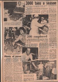
Newspaper - LYDIA CHANCELLOR COLLECTION: BENDIGO PRESERVING COMPANY
An article including black and white photographs on the Bendigo Preserving Company from the Bendigo 'Advertiser.' It includes photographs of employees at work and information on the B.P.C. itself. Two pages. 24/2/1970.bendigo, industry, tomatoes, lydia chancellor collection, collection, fruit, bendigo, history, bendigo preserving company, mr. ron potter, cannery, b.p.c., tomatoes, farm, farming, food technology, industries, employees, b.p.c. employees, inglewood, canning, agriculture -
 Bendigo Historical Society Inc.
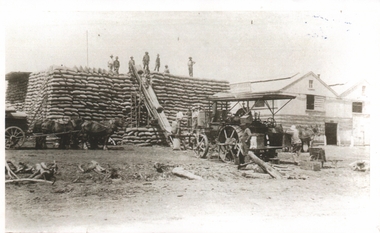
Photograph - JOAN LEVERSHA COLLECTION: WHEAT STACK AT SHELBOURNE
... AGRICULTURE Farm Shelbourne Black and white photograph showing 7 men ...Black and white photograph showing 7 men on top of a big stack of wheat bags. The bags are sent up via a conveyor belt driven by a stem engine, several men are at the bottom and around the enginea cart with 4 horses can be seen at left waiting for the bags to be unloaded and sent up for stacking. Two buildings can be seen at the right.agriculture, farm, shelbourne -
 Bendigo Historical Society Inc.
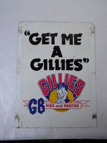
Functional object - Get a Gillies sign
Gillies Pies was started by three brothers from Charlton, in central Victoria, Les, Alan and Norm Gillies who left their farm after the 1940s drought and headed to Bendigo to start anew. From their first small bakery in Mitchell Street, the brothers eventually went on to employ about 200 people with wholesale and retail locations spreading across the state and distribution including Melbourne.A double-sided sign, both sides are identical. A white sign with black writing "GET ME A GILLES''. Red writing with blue shadows GILLES curved above the face of a boy eating a pie. GB PIES AND PASTIES There are three holes on each side for mounting.gilles pies, signs -
 Bendigo Historical Society Inc.
Map - GUIDE MAP OF BENDIGO & EAGLEHAWK, Late 1920's
Map. Guide Map of Bendigo & Eaglehawk. Light brown coloured booklet containing folded map of Bendigo and Eaglehawk. Outer cover is printed in blue and red ink and states - With compliments of J H Curnow & Son, Auctioneers, Real Estate Agents, Farm & Dairy Produce Merchants, Bendigo. Printed by J B Young, Lithographer. Map shows tramways & bus routes. Map shows Agricultural Showgrounds located between Park Street, Water Street, Barnard Street and Bridge Lane. Also shows Acclimitization Reserve located behind The Botanical Gardens at White Hills. Shows the location of Sailors Gully, Peg-Leg Gully, Jobs Gully, California Gully, Long Gully, Ironbark Gully, Golden Gully, Poverty Gully, Sheepshead Gully, Charcoal Gully, Eaglehawk Creek, Bendigo Creek and Back Creek. Contains interesting facts about Bendigo - Area 7,900 acres. Population - 26,000. First Council elected - 1855. Proclaimed a Borough - 1863. Proclaimed a City - 1871. Gold Rush broke out - 1851. For first 10 years gold yield averaged 8,600 ozs. per week . Total gold yield to 1923 - 572 tons valued at 82,000,000 pounds. Deepest mines - Victoria Quartz 4,614 ft., New Chum Railway 4,318 ft. 13 mines over 3.000 ft. deep. 53 mines over 2,000 ft. deep. Sewering of City commenced 1922, all principal buildings now sewered. Map printed by Arnall & Jackson, General Printers, Stationers & Engravers, 476 Collins Street. Map displays advertisement for J H Curnow & Son, Bendigo's leading Auctioneer and Estate Agents, Mitchell & Queen Sts. Bendigo. Map Scale 20 chs. = 1 in.cottage, miners, guide map of bendigo and eaglehawk -
 B-24 Liberator Memorial Restoration Australia Inc
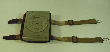
Computer Navigational MkIII D, White & Gillespie (Melb) Pty Ltd, c. 1940
RAAF Manual navigation aircraft calculator(early computer)General issue to allied pilots and navigators for airspeed,altitude,air temperature and drift calculations.Black metal box with SS flap-top cover, moulding and straps for knee attachment.Engraving No. 19, Ident.No. G6B/145. I.C.A.N. Serial No. WG/1716*. Computer Navigational Mk.IIID -
 B-24 Liberator Memorial Restoration Australia Inc
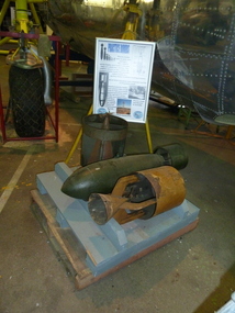
WWII Practice Bombs
Practice bombs could be service bombs, inert loaded with sand, water for chalk/lime solution. Standard practice bombs were painted white overall with two light green bands painted around centre of the tail. Inert service bombs painted black and those containing an exploder had a red band around the body.a14 -
 B-24 Liberator Memorial Restoration Australia Inc
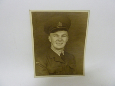
Black and White Photographs of Bill Bakker
Included in the collection of Bill Bakker ex RNEIAAFBlack and white photograph of a young Bill Bakker. Black and white photograph in a frame of Bill Bakker.a23.08 -
 B-24 Liberator Memorial Restoration Australia Inc
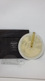
Graviscope, W&G, Graviscope for Liberator, circa 1942
Standard crew issue for pilots and flight engineers.The equipment supplied air crew with a computer to calculate individual aircraft's weight and balance.2 Circular plastic manual computing discs with black print on a white background with areas for calculating Centre of gravity, Armament, Bomb loadings,Fuel, oil,Crew, Miscel., Oxygen and Camera. Clear plastic protractor with string attached. Enclosed in a leather envelope.GRAVISCOPE FOR LIBERATOR. MODEL B24J, L AND M. MANUFACTURED BY MELB. >W&G< AUST. R.A.A.F IDENT NO G6B/2396 -
 City of Whittlesea
Photograph (item) - Photographs - Buildings, Summerhill Farm
Summer Hill at Craigieburnsherwin family, wollert, dr thomas wilson -
 St Kilda Historical Society
Photograph - Photo map, 17/01/1951
One of a series of photo-maps produced for the Department of Crown Lands and Survey (1857-1983). For correlation with a current map, and access to other historical photo maps of Victoria, see the Historic Photo-Maps Index published by the Department of Environment, Land, Water and Planning at https://services.land.vic.gov.au/DELWPmaps/historical-photomaps/Black and white aerial photograph1414-21 538 Run 19 Lens 12" Melbourne Metropolitan 12150 17.1.51 M586st kilda, st kilda botanical gardens, peanut farm, elwood, 1951, point ormond, elwood canal, st kilda beach -
 St Kilda Historical Society
Photograph - Photo map, 30/01/1960
One of a series of photo-maps produced for the Department of Crown Lands and Survey (1857-1983). For correlation with a current map, and access to other historical photo maps of Victoria, see the Historic Photo-Maps Index published by the Department of Environment, Land, Water and Planning at https://services.land.vic.gov.au/DELWPmaps/historical-photomaps/Black and white aerial photographVic 1092-38 Melbourne & Metropolitan Project Run 22 30.1.60 Lens 10" 8.200st kilda, st kilda beach, st kilda pier, catani gardens, 1960, st kilda botanical gardens, peanut farm -
 St Kilda Historical Society
Photograph - Photo map, 14/12/1963
One of a series of photo-maps produced for the Department of Crown Lands and Survey (1857-1983). For correlation with a current map, and access to other historical photo maps of Victoria, see the Historic Photo-Maps Index published by the Department of Environment, Land, Water and Planning at https://services.land.vic.gov.au/DELWPmaps/historical-photomaps/Black and white aerial photographVic 1807 Melbourne 1963 Project Run 17 14.12.63 Lens 205 152,70 M/M 5.150 34st kilda, peanut farm, point ormond, st kilda marina, st kilda pier, 1963 -
 St Kilda Historical Society
Photograph - Photo map, 12/04/1966
One of a series of photo-maps produced for the Department of Crown Lands and Survey (1857-1983). For correlation with a current map, and access to other historical photo maps of Victoria, see the Historic Photo-Maps Index published by the Department of Environment, Land, Water and Planning at https://services.land.vic.gov.au/DELWPmaps/historical-photomaps/Black and white aerial photographVic 1933 Melbourne 1966 Project Run 12 12.4.66 Lens 122 151.75MM 9.800 154st kilda, st kilda east, balaclava, toorak, amadale, caulfield, south yarra, st kilda botanical gardens, peanut farm, 1966 -
 St Kilda Historical Society
Photograph - Photo map, Department of Crown Lands and Survey (1857-1983), 22/01/1970
One of a series of photo-maps produced for the Department of Crown Lands and Survey (1857-1983). For correlation with a current map, and access to other historical photo maps of Victoria, see the Historic Photo-Maps Index published by the Department of Environment, Land, Water and Planning at https://services.land.vic.gov.au/DELWPmaps/historical-photomaps/Black and white aerial photographVic 2358 Department of Crown Lands and Survey Victoria,.© Melbourne 1970 Project Run 42E 22.1.70 5,100 ASL 77st kilda, st kilda east, st kilda marina, elwood, elwood canal, elsternwick park, point ormond, balaclava, mc moran reserve, ripponlea, st kilda botanical gardens, peanut farm, 1970 -
 El Dorado Museum Association Inc.
Photograph (item) - Digital Image
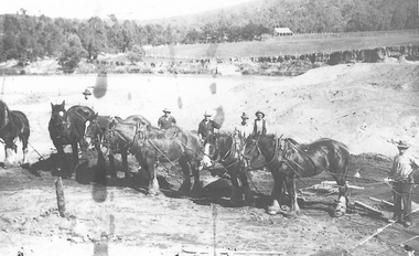
Horse team , Cocks Pioneer Cocks Pioneer Electric Gold & Tin Mine Company was formed in 1899. The company's first power station, located at the eastern end of the valley began operating with its 340 Kilowatt steam-powered generator. By 1909, from 2,500,000 cubic yards worked, reported recovery was 17 284 ounces of gold and 224 tons of tin ore. By 1909, Cocks Pioneer’s power plant had become inadequate and uneconomical. The barge was floated downstream about a mile, but lost time caused the operations to cease. Following testing, a new mine was established by diverting Reid's Creek at a cost of £25,000. Settling dams were built, one of which held 1,935,900 cubic feet. Sold earth banks, built against a wall of stringy bark saplings constructed and laced with vertical props, were built. In 1914, the company was reformed as Cock’s Pioneer Gold and Tin Mines NL, another power station was constructed at the western end of the township, near the junction of Clear and Reid's Creeks. From 6,800,000 cubic yards of material processed, the returns were 64,397 ounces of gold and 855 ton of tin. Cocks Pioneer mine then moved the barge downs stream and continued sluicing. In 1929 Cocks Pioneer Electric Gold and Tin Mining Company ceased operations due to a drop in values. Cock’s Pioneer Gold and Tin Mines NL carried on large-scale hydraulic sluicing operations until 1941. mining, gold, tin, sluicing, men, cocks pioneer, el dorado, eldorado, horses, gold mining, tin mining -
Tatura Irrigation & Wartime Camps Museum
Photograph, Dhurringile Mansion Wheat Grader, 1931
... Tatura the-murray Early example of farm machinery. Contractors ...Early example of farm machinery. Contractors would go from farm to farmBlack and white photograph of wheat grader Hec. McLennan's wheat grader at Tom Hastie's farm 1931.tom hastie's farm, early farm equipment -
Tatura Irrigation & Wartime Camps Museum
Book, Department of Agriculture Victoria, Institute for Sustainable Agriculture, 1993
Investigation of salinity problems by staff at Tatura, Kyabram, Shepparton, and Cobram Institutes.Department of Agriculture photos on front. Saline waterlogged land near Shepparton. Measuring white clover growth. Salinity management plans for research. Farm planning blueprint. Satellite image of plains and Lodden river.salinity, department of agriculture, kyabram, tatura, shepparton, cobram -
Tatura Irrigation & Wartime Camps Museum
Photograph, Chas Brady Story
Original photograph of Chas Brady's Store in Casey Street, Tatura. One of the very early stores in Tatura. Grocer, draper, general merchant. Also partly in photo, is a farm machinery store, Horsby, Reapers, Binders.Black and white photograph of Chas Brady Store in Casey Street, Tatura. Horse and cart, men and women and children outside store but names unknown.Chas Brady Store Casey Street Tatura.chas brady store tatura -
Tatura Irrigation & Wartime Camps Museum
Book, The Italian Farming Soldiers, 1981
Written to show role of Italian POW's as labour on farms from 1941-1947Red hard cover. Map of Australiain green, white and red. italian POW's and camp scene and Italian farmers.italian pow's, books, history, local, reference -
Tatura Irrigation & Wartime Camps Museum
Booklet, Dhurringile and The Delle's, 2001
Written to record family history of life on Dhurringile farm and early history of tomato growng at Dhurringile and TaturaInside a plastic bag. White cover, brown writing, blue border. Sketches of caravan truck, tomato, fish, farmer, cow, dog, snake. Photo of truck used for delivering tomatoes to Melbourne market on back coverdhurringile, dell vergin family, tatura, tomato industry, books, history, local, rural, industries -
Tatura Irrigation & Wartime Camps Museum
Book, Dhurringile & The Delle's, 2001
Written to record family history of life on Dhurringile farm and early history of tomato growing industry at Dhurringile and TaturaIn a plastic bag. Black and white copy of covers of Book 4214dhurringile, delle vergin family, tatura, tomato industry, books, history, local, rural, industries -
 Tatura Irrigation & Wartime Camps Museum
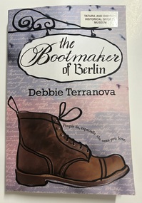
Book - Paperback Book, The Bootmaker of Berlin
Berlin, 2010: A deathbed promise launches Kathy Giuliano on a quest for the truth about her family during World War II. Alone, she travels to Berlin in search of an enigmatic octogenarian who holds the keys to the past. The only clues to his identity and whereabouts and are a black-and-white photograph and an outdated address in Reinickendorf. England, 1938: After fleeing Nazi Germany for the safety of England, a teenage boy is captured when Churchill gives the order to 'collar the lot'. One of 2,000 prisoners on the hell-ship Dunera, he is sent to Australia. At the 'family camp', he makes footwear and forms life-long friendships. Eight years later, what does he find when he returns to Berlin? Victoria, 1943: With the Japanese at Australia's doorstep, a mother and daughter are arrested at their cane farm in far north Queensland and sent 'down south'. Their crime? Teaching the Italian language to school-children. The internment camp at Tatura changes everything. The secrets they share must be kept for the rest of their lives.Mauve and Pink cover with a painting of a large brown lace up boot. The book title is depicted on a wrought iron sign. non-fictionBerlin, 2010: A deathbed promise launches Kathy Giuliano on a quest for the truth about her family during World War II. Alone, she travels to Berlin in search of an enigmatic octogenarian who holds the keys to the past. The only clues to his identity and whereabouts and are a black-and-white photograph and an outdated address in Reinickendorf. England, 1938: After fleeing Nazi Germany for the safety of England, a teenage boy is captured when Churchill gives the order to 'collar the lot'. One of 2,000 prisoners on the hell-ship Dunera, he is sent to Australia. At the 'family camp', he makes footwear and forms life-long friendships. Eight years later, what does he find when he returns to Berlin? Victoria, 1943: With the Japanese at Australia's doorstep, a mother and daughter are arrested at their cane farm in far north Queensland and sent 'down south'. Their crime? Teaching the Italian language to school-children. The internment camp at Tatura changes everything. The secrets they share must be kept for the rest of their lives.ww2 italians, internment, tatura, queensland, debbie terranova, berlin -
 Tatura Irrigation & Wartime Camps Museum
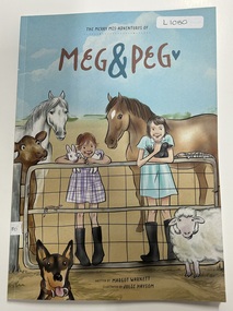
Book - Paperback Book, The Merry Mis-Adventures of Meg & Peg, 2021
Author Margot Warnett grew up on a Dairy farm just outside TaturaA4 size paperback book with predominantly blue sky and an illustration of two girls standing on a wire farm gate. One girls has a purple check dress on, black gum boots and holding a white rabbit. The other girls has a blue dress, gum boots and holding a black duck. A white and brown horse, a calf, a sheep and farm dog and a lizard are also in the picture. The two girls are also pictured on the back cover.Written by Margot Warnett Illustrated by Julie Haysomwarnett, book, children, meg and peg, dairy farm -
 City of Ballarat
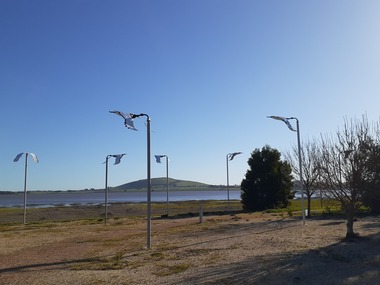
Artwork, other - Public Artwork, Friends of Learmonth, Flock by The Friends of Learmonth
The Flock is a kinetic sculpture made up of 11 parts. It celebrates a local migratory bird, the ibis. The sculpture comprises tall steel poles with a steel ibis balanced on the top of each pole by its beak. Balanced on a spherical joint to allow fluid movement in all directions, each element of the Flock is designed to look like a bird in flight. The kinetic wind-powered elements of the artwork were inspired by the nearby Waubra Wind Farm.The artwork is of aesthetic and social significance to the people of BallaratEleven white and black birds on poles with moving partsibis, friends of learmonth, learmonth -
 Lake Bolac & District Historical Society
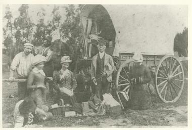
Black and white photograph, Travelling salesman at Lake Bolac
Travelling salesmen (hawkers) regularly journeyed from farm to farm selling useful household items like needles, thread, clothing, even cooking pots. Mr T Saker was a salesman selling drapery. He was based in Warrnambool and had a regular route to Lake Bolac and through the Western district.lake bolac, hawkers, drapery, warrnambool, western district -
 Lake Bolac & District Historical Society
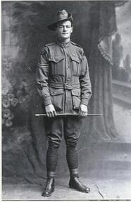
Black and white photograph, Private Louis (Joe) Murdoch Murray, 8th Lighthorse regiment, WW1
Private Louis (Joe) Murdoch Murray, 8th Light Horse Regiment, WW1. Joe enlisted 15/01/1915 and embarked for overseas on 07/05/1915. He served at Gallipoli and in France where he was badly wounded at the battle of Ypres in 1917. After returning from the war he took up farming on land donated to him by the Austin family. However, he never fully recovered either physically or mentally from his war service and lost his farm in the Depression. He spent his final years in an Old Soldiers Home in Frankston. He is buried in Melbourne.murray, 8th light horse regiment, ww1, gallipoli, ypres, austin, old soldiers home - frankston, melbourne. -
 Lake Bolac & District Historical Society
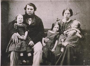
Black and white photograph, E & M Rowley, pioneers at Lake Bolac, 1862
Edward and MaryAnn Rowley were pioneer settlers at Lake Bolac, taking up land in 1862. Their children were Sarah, Elizabeth, Maryanne, Deborah, Emily, Ellen, Eliza, Emma, Martha and Edward. The change-over station for stage coaches, including Cobb and C., and paddocks for resting horses, were on their property. The farm was later bought by J.T. Murray. The family are interred in the Lake Bolac Cemetery.lake bolac, rowley, pioneer settlers, 1862, murray, cobb and co. -
 Lake Bolac & District Historical Society
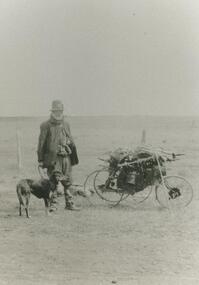
Black and white photograph, Swagman
Swagman, travelling through the Lake Bolac district. These 'swaggies' often had regular, seasonal 'runs' which they would follow, returning to the same hamlets and farms at the same time every year to ask for minor chores in order to earn a meal or to obtain some flour, tea and sugar. After both wars, the numbers of swaggies increased as returned soldiers, who couldn't settle to (or couldn't find) regular employment, took to the roads.lake bolac, swagman