Showing 371 items
matching timber bridges
-
 Charlton Golden Grains Museum Inc
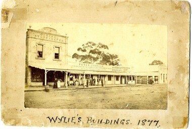
Photograph, Wylie's Buildings 1877, c. 1877
Earliest known photo of the stores. Johnson's Bridge store built 1873. Procter's c. 1876. Western end, left hand side of High Street, Charlton. Earliest known photo of the storesPhotograph of Peter Johnson's Bridge Store High St Charlton. Titled Wylie's Buildings 1877. Group of people on footpath. Peter Johnson's store, Reed Chemist shop, Procter's Butcher shop, Bank of New South WalesWylie's Buildings 1977peter johnson a.d. 1877 general storekeeper, peter johnson, draper, iron monger, timber merchant, general produce, jas reed, druggist, butcher, r procter & son, business, industry -
 Bendigo Military Museum
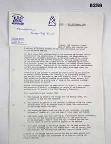
Document - SURVEYORS RESTORATION REPORT BENDIGO, Bendigo City Council, c.1986
Surveyors report 1986 regarding the restoration of the Bendigo Cenotaph continued on from Cat No 8255. The document starts with a report to a Council meeting held on August 18th 1986. This is a more detailed report of the first by Dr. A.H. Spry (AMDEL) followed by Mr W. Barton City Engineers Department. The state of the Cenotaph was also compounded by it's situation re the Bendigo Creek. Main points where. The Cenotaph is sited on the Bridge over the Creek not alongside it as was supposed. The Cenotaph concrete foundation was resting on the old timber decking which is in an advanced state of decay among 5 main points. Report goes on with points. Conclusion; "It would of course be necessary to demolish the Cenotaph to carry out this work". Estimate of costs in brief. 1. Bridge repairs $72,000.00. 2. Cenotaph repairs. - Demolish & rebuild $110,000.00. Options - There are only two options (as per estimate) or demolish and relocate to another location under 3 sections (a) (b) (c). Recommendations; Motions referred to Estimates 1986/87 and RSL for comments - 1 carried, 1 lost.Document, paper 3 pages foolscap size, all print in black, copy of original, stapled with the pages is a Bendigo City Compliments Card in blue text.Main points, "Building Surveyors report - 8th September 1986 - B.18/86 - restoration of Cenotaph (32.7.1)"document, surveyor, cenotaph, brsl, smirsl -
 Bendigo Military Museum
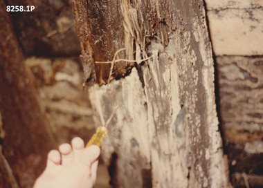
Photograph - CENOTAPH RESTORATION WORKS, C.1987
These photos following on from Cat No 8255 and the progress towards the Restoration of the Bendigo Cenotaph over the Bendigo Creek.Six photographs all colour 5" x 7". The photos show various stages of the restoration of the Bendigo Cenotaph over the Bendigo Creek, the timber decay, new foundations, footings, above the bridge and below & under.A note on .3) states, "Reo footing Sun morning 23.8.87"brsl, smirsl, cenotaph, bendigo -
 Lakes Entrance Historical Society
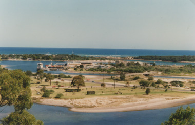
Photograph - Apex Park Lakes Entrance Victoria, M Holding, 1985 c
The town section of North Arm previously known as The Blackwater.Road and new bridge to Bullock Island Apex Park beside North Arm in foreground has old playground equipment with timber fort and hillock with underground tunnel Lakes Entrance VictoriaColour photograph taken from Kalimna Heights showing outer barrier and entrance channel. Road and new bridge to Bullock Island Apex Park beside North Arm in foreground has old playground equipment with timber fort and hillock with underground tunnel Lakes Entrance Victoria topography, waterways, gippsland lakes, parks, bullock island -
 Bendigo Historical Society Inc.
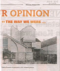
Newspaper - COHN BROTHERS COLLECTION: COHNS BREWERY PHOTO ( COPY)
Three Cohn brothers, Jacob, Julius and Moritz came to Bendigo from Denmark in 1852. They were followed by their brother Solomon (Henry) in 1858. Jacob (1830-1911) married Rosa Levy in 1858 during a return trip to Denmark. Moritz (1822-1878) married Roschen Ballin in Germany in 1861. Julius (1828-1877) married Rosetta Spyer in Victoria in 1866. Henry (1826-1874) was married to Leah Fonseca.. Jacob, Moritz and Julius began the Victoria Brewery in Bridge Street in 1858, whilst Henry was described as a traveller and collector for Cohn Bros. in 1859. The brothers soon expanded into the making of cordials (soft drinks). In 1866 Henry took up a hotel in Sandridge (Port Melbourne). Moritz moved to Talbot and set up his own brewery before returning to Bendigo after Julius' death.Newspaper copy of photo of Cohns Brewery, undated picture, presented in the Bendigo Advertiser, Wednesday February 4, 2015, in 'The Way We Were'. Image shows timber, brick and stone insert on front (back?) of building. Wooden barrels in front of building, galvanised iron partitioned bins, along side of LH building. Appears to be the back of the building.bendigo, industry, cohn bros brewery -
 Clunes Museum
Painting - PAINTINGS, David Williams
Images of; Horse Trough & Wagon Residence 94 Bailey Street Former Presbytery St. Thomas Aquinas Former Clunes Free Library Residence 25 Camp Street Monument 100 years of gold Clunes in Melb Monument Former butcher's shop Fraser Street Residence & shops 41-43 Fraser Street Clunes School of Mines Clunes War Memorial Residence 32 Leslie St Clunes Former suspension bridge Former St Paul's Vicarage 42 Service Street Former Police Office Former Police residence Portable Lock Up Former Dow Residence 9 Hill St Former Hall & Fire Station 2 Hill St St Paul's timber Church hall St Paul's Church Masonic Lodge 23 Service St St Paul's Pulpit Masonic Lodge interior Everhard cordial bottles Scythes in Clunes Museum Ascot Blacksmith shop Former Ascot hotel MIA Hall Ascot The Coghill Monument Former Methodist Church Coghills Creek Clunes Cemetery Chapel Maiden Hill Homestead shearing shed Beckworth Court stables Beckworth Cour shearer's quarters Former School Evansford Glengower Outbuilding Amerst Former Mortuary 46-50 Fraser Street Wood fired heater Beckworth court farm shed Gold mine trolley Servant's bells Maiden Hill cow bail Former South Clunes school 29 George Street 70 Fraser Street Former Post Office "Allowah" Clunes Street Ascot "Homestead" Beackwith Court "The Meat House" Beckwith Court "Shearing Sheds" Beckwith Court Evansford Community Hall 54 watercolours remaining from the 2003 exhibition held at Clunes, all unframed, depicting Clunes and surrounds architecture and streetscapes.watercolour, 2003 exhibition -
 Stawell Historical Society Inc
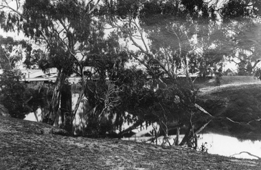
Photograph, Bridge over Wimmera River at Glenorchy
Bridge over Wimmera River at Glenorchy. Church in background on right is the former Presbyterian now United Church. Original photograph taken by Charles Nettleton.Black & white photograph of a timber lined water body with bridge and building in the background. water -
 Lakes Entrance Historical Society
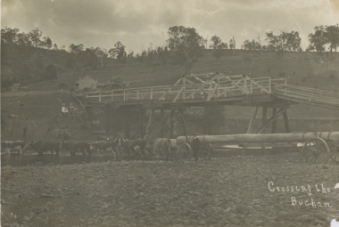
Photograph, John Flynn, Crossing the Buchan, 1906
Bridge was built in 1896 and never finishedBlack and white photograph of bullock team pulling timber jinker with very long logs across the Buchan River beside the footbridge. Several men in charge of team and four girls on the hill, cottage and barn seen, bridge not finished Buchan VictoriaCrossing the Buchantransport, waterways, bridges, people -
 Flagstaff Hill Maritime Museum and Village
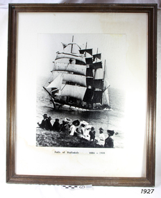
Photograph - Vessel, Sailing Ship, Falls of Halladale 1886 - 1908, 1908
The photograph shows some of the hundreds of sightseers who visited the site of the wreced Falls of Halladale, watching the fully rigged ship slowly disintegrate over two months or more. The Falls of Halladale was a four-masted sailing ship built in 1886 in Glasgow, Scotland, for the long-distance cargo trade and was mostly used for the Pacific grain trade. The ship was sturdy. It could carry maximum cargo and maintain full sail in heavy gales. It was one of the last of the ‘windjammers’ that sailed the Trade Route, and one of the first vessels to include fore and aft lifting bridges, which kept the crew safe and dry as they moved around the decks in stormy conditions. It was one of several Falls Line ships named after the waterfalls of Glasgow by its owner, Wright, Breakenridge & Co of Glasgow. On 4th August 1908, with new sails, 29 crew, and 2800 tons of cargo, the Falls of Halladale left New York, bound for Melbourne and Sydney via the Cape of Good Hope. The cargo on board was valued at £35,000. It included 56,763 tiles of American slate roofing tiles, 5,673 coils of barbed wire, 600 stoves, 500 sewing machines, 6,500 gallons of oil, 14,400 gallons of benzene, plumbing iron, 117 cases of crockery and glassware and many other manufactured items. The Falls of Halladale had been at sail for 102 days when, at 3 am on the 14th November 1908, under full sail in calm seas with a six knots breeze behind and misleading fog along the coast, the great vessel rose upon an ocean swell and settled on top of a submerged reef near Peterborough on south-west Victoria’s coast. The ship was jammed on the rocks and began filling with water. The crew launched the two lifeboats and all 29 crew landed safely on the beach over 4 miles away at the Bay of Islands. The postmistress at Peterborough, who kept a watch for vessels in distress, saw the stranding and sent out an alert to the local people. A rescue party went to the aid of the sailors and the Port Campbell rocket crew was dispatched, but the crew had all managed to reach shore safely by the time help arrived. The ship stayed in full sail on the rocky shelf for nearly two months, attracting hundreds of sightseers who watched her slowly disintegrate until the pounding seas and dynamiting by salvagers finally broke her back, and her remains disappeared back into deeper water. The valuable cargo was largely lost, despite two salvage attempts in 1908-09 and 1910. Further salvage operations were made from 1974-1986, during which time 22,000 slate tiles were recovered with the help of 14 oil drums to float them, plus personal artefacts, ship fittings, reams of paper and other items (a list of items held at Flagstaff Hill Maritime Village is included below). The Court of Marine Inquiry in Melbourne ruled that the foundering of the ship was entirely due to Captain David Wood Thomson’s navigational error, not too technical failure of the Clyde-built ship. The shipwreck is a popular site for divers, about 300m off-shore and in 3 – 15m of water. Some of the original cargo can be seen at the site, including pieces of roof slate and coils of barbed wire. ABOUT THE ‘FALLS OF HALLADALE’ (1886 - 1908) Built: in1886 by Russell & Co., Greenock shipyards, River Clyde, Scotland, UK. The company was founded in 1870 (or 1873) as a partnership between Joseph Russell (1834-1917), Anderson Rodger and William Todd Lithgow. During the period 1882-92 Russell & Co., standardised designs, which sped up their building process so much that they were able to build 271 ships over that time. In 1886 they introduced a 3000 ton class of sailing vessel with auxiliary engines and brace halyard winches. In 1890 they broke the world output record. Owner: Falls Line, Wright, Breakenridge & Co, 111 Union Street, Glasgow, Scotland. Configuration: Four-masted sailing ship; iron-hulled barque; iron masts, wire rigging, fore & aft lifting bridges. Size: Length 83.87m x Breadth 12.6m x Depth 7.23m, Gross tonnage 2085 ton Wrecked: the night of 14th November 1908, Curdies Inlet, Peterborough south west Victoria Crew: 29The Falls of Halladale shipwreck is listed on the Victorian Heritage Register (No. S255). It was one of the last ships to sail the Trade Routes. The ship was one of the first vessels to have fore and aft lifting bridges. The wreck is an example of an International Cargo Ship and represents aspects of Victoria’s shipping industry. The wreck is protected as a Historic Shipwreck under the Commonwealth Historic Shipwrecks Act (1976).Photograph, behind glass in a timber frame. Image of a group of people seated on the ground with the stranded barque, the Falls of Halladale, in full sail nearby in the water. The photograph was taken at Peterborough, southwest Victoria, on November 13th 1908. A typed inscription is below the picture.Typed beneath photograph "Falls of Halladale 1886 - 1908"flagstaff hill, maritime museum, maritime village, flagstaff hill maritime museum and village, great ocean road, shipwreck, peterborough, falls of halladale, 1908, barque, scotish, 4-masted, sailing ship, 1886, glasgow, trade, grain trade, cargo, windjammer, fore and aft bridges, falls line, wright, breakenridge & co, american slate, roofing tiles, barbed wire, sewing machines, oil, benzene, port campbell rocket crew, sightseers, salvage, captain david wood thomson, captain thomson, navigational error, clyde-built, russell & co -
 Eltham District Historical Society Inc
Film - Video (DVD), Melbourne and Metropolitan Board of Works, Yarra River Conference Proceedings; a Board of Works centenary event, 13-16 April 1991
Yarra River Conference History Segment [Noted on VHS tape jackets "Due to unavoidable circumstances, the quality of these tapes in some setions is less than desired."] The Yarra River Conference, organised by the Board of Works as part of the Centenary Celebrations, was held in the Board's Head Office Theatrette from 13-16 April, 1991. A segment of the Conference focussed on the role that the Yarra River has played in relation to the historical development of Melbourne. Conceived and presented by a group of prominent historians as a chronological 'trip down the river in time', and profusely illustrated with slides, this segment traced the various impacts that urban and rural growth, development of marine commerce, recreational uses, and environmental problems have had on the Yarra during a century and a half of European occupation. As no formal written paper of this combined presentation is available, these two video-tapes provide a record for anyone who has an interest in tis fascinating aspect of the Yarra's history. The speakers who combined to present this segment are identified on the cover of Tape 2. Tape 1 (2 hours) 1838-1863 Deputy ?? to Utility Early navigators of the Yarra River; developing the port of Melbourne; the gold rush and its effect on the new colony; punts and bridges; water supply; pollution of the Yarra; the discovery of gold and early settlement of the Yarra valley; floods of 1839 and 1863. 1863-1891 Formation of the Harbour Trust; Coode Canal; pollution of the Yarra by industry; aborigines, gold miners, timber getters in the Upper Yarra areas; bridges; the flood of 1891. Tape 2 ( 1 1/2 hours) 1892-1934: People Begin to See Beauty and Romance to the River Henley-on-Yarra; realignment of the Yarra; MMBW is responsible for a sewerage system; new docks to cope with increased overseas trade; development of recreational parks; new reservoirs; timber production and timber tramways; bushfire; flood of 1934. 1935-1970: The River is Neglected Still, Except When it Proves Useful Bushfirs of 1939; the end of many sawmills; birth of tourism; increased interest in conservation and preservation of land for open space; further augmentation of water supply system; birth of containerisation changes the port; environmental concerns gain momentum. Speakers Dr Tony Dingle *, Department of Economic History, Monash University Dr Carolyn Rasmussen *, History Consultant Prof. Graeme Davison, History Department, Monash University Mr. Tom Griffiths, Lecturer in Public History, Monash Uiversity Mr. Patrick Miller, History Consultant Mr. Colin Jones, Author and Historian * Co-authors of the Board's history, 'Vital Connections'.video recording, yarra river, conference proceedings -
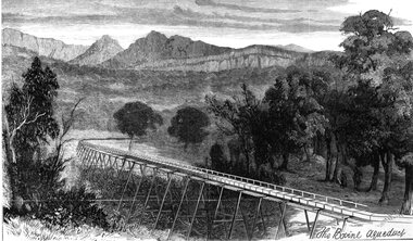 Stawell Historical Society Inc
Drawing, Stawell Water Supply Bovine Aqueduct 1881 -- Sketch
Sketches of Stawell Water Supply Bovine Aqueduct October 5th 1881. The Grampian scheme planned by the the Borough Engineer John D'Alton. D'Alton's suggestion was that the water be carried from the source in an open channel two miles, then in a flume of timber. Later surveyed and planned a tunnel on a good line - to reduce the flume 72 miles and the main to Stawell to 15 miles. This sketch (illustrated Australian News October 5, 1881).Black and white photograph of a sketch a bush scene with mountains in background. The sketch depicts a trestle bridge construction. The Bovine Aqueduct stawell water supply