Showing 443 items matching "trestle"
-
 Eltham District Historical Society Inc
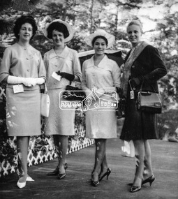
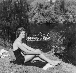
Photograph, Joy Chapman, Miss Eltham 1965 with other contestants, Apr 1965
My Recollections of Eltham Past by Margaret Joy Harding (nee Joy Chapman.) My family of Elizabeth and Alec Chapman moved to Eltham in 1946 into a cottage on the opposite side of the Diamond Creek from where the little train now operates in the Lower Park. At that time Eltham truly was a country town and the Pub was the main meeting place for most inhabitants on a Saturday afternoon in the beer garden. I attended Eltham Primary School where I started as a 4-year-old (my birthday being slightly after the mid-year intake) that happened then. My mother spent a lot of days taking me back to school when I had dismissed myself and walked the one kilomtre home alone. Bremner's Common (now Wingrove Park) was a big attraction with its dam and tad poling which I found much more entertaining than school. (Mrs Bremner ran a Service Station on the site of the current one). Another attraction at this site was the circus that came a couple of times a year. Watching them put up the circus tent was very interesting and even more of an attraction was the feeding of the Lions in cages and the monkeys and elephants among the other animals that are not found in a circus these days. At school then we were provided with hot chocolate at morning recess where the mothers would prepare it in the shelter shed. The only form of classroom heating was an open fire. Worse was the warm milk given in the summer months. By the time I was near finishing at Primary school we used to be able to walk along the Main Road at lunchtime to Mrs. Mitchell's shop to a delicious hot pie. As I recall there was no supervision for this departure from the school grounds. It is interesting that some of the other children I started school with I still have contact with, in fact one is a very good friend although now living in Perth. That is the other thing about Eltham; many who grew up here continue to live in the area. Following primary school, the natural progression was to Eltham High School. There was only the main building at that time and I can remember our first assembly at the front entrance. During the time I was at High School several new class rooms were added and the school hall. I remember the musical plays such as HMS Pinafore and other classical musicals being performed. I also remember countless hours doing marching practice. The main street shops when I was young consisted of the Blue Gum milk bar at the far end, a Grocery store and a shoe maker where Coles currently stands. Opposite there was Lyon's Garage. They also provided a bus service and when we got off the train this little bus would tour the back streets taking each individual to their home, sometimes this could take quite considerable time. There was also a Black Smith next to the Chiropractic Practice opposite Alistair Knox Park, another Milk Bar/General Store on the comer of Bridge Street/Main Road where a shop currently still operates. There was also a Butcher's shop down from the pub opposite Franklin Street. The only doctor was next to the courthouse on the other side of Brougham Street. On Saturday afternoon I was occasionally allowed to go the movies in the Town Hall which also stood on the site of the Coles centre. Often the Fire Alarm would sound and everyone would run outside to watch the fire truck leave with the volunteers clutching on the back. The other attraction during summer of course was the swimming pool which was a small concrete pool filled with water pumped from the Diamond Creek, sometimes it was like a mud puddle so for me the nearer to home Yarra/Diamond Creek junction was a much better option. We swam in the water hole which was quite deep and with fallen trees and sometimes carcasses of cows and kangaroos floating past. As recreation, the churches were another attraction for the Sunday school picnics to Mordialloc in the back of the moving van with benches tied into the back for us to "sit" on. Too bad when we went around a corner! In the early days we had an Ice Man deliver the ice once a week for "refrigeration". The green grocer came around in a horse and cart as did the milkman and the bread was delivered but I constantly got into trouble for eating the middle out on the way from the box it was delivered to in Mt Pleasant road across the paddock. The milkman finally would not come down our street after his horse bolted one morning and took off across the paddock. We also had the "Pan Man" come weekly and whose visit I would avoid. Our nearest shop was where the flower stall is located opposite the Lower Park. It consisted of a Tea Room and Milk Bar. There was a Public Telephone there which was the only contact to anyone else. We were a one car family so my mother’s movements were very limited as the Eltham Station was a couple of kilometres away and a trip to the city was an event. Being an only child growing up was a little lonely however rambling along the creek with my Mum, picking mushrooms and picking cherry plums for jam and the dogs catching rabbits which we ate if we could get them away from the dogs. We also liked to go into the Lower Park during school holidays when the Greek people came to camp and they would sing and dance around the camp fire and it all seemed so different to us as this was early days of immigration. Childhood was relatively simple and carefree and I wish the kids of today had the freedom of my youth and the healthy outdoor lifestyle of the "olden days". SHOW GIRL COMPETITION In 1965 Eltham was more like a country town than the suburb it has become today. People knew each other, if not personally then certainly of the family name. The big event for the year was a Gymkhana or show at Lower Eltham Park. I can remember marching as a teenager from the town centre to the park in the marching girls with the decorated floats. In 1965, just on a whim on the day, I decided to enter the Miss Eltham Show Girl which was a part of the festivities at the park. I seem to remember that the show mainly consisted of horse events, cattle judging and dog show. As I had not given any serious thought to entering the competition, I wore a suit that I had for work which was brown wool, with a coffee coloured shirt under, black shoes, bag, and gloves but no hat. I duly paraded for the judges and much to my surprise I was announced the winner. I eventually went on to compete at the Miss Victoria Show Girl competition which was held at the Royal Melbourne Show. There I met many country girls who were representing their rural Victoria home. I made it into a final round of judging but I think justice prevailed when someone from a country background was crowned. It was fun to go into the show as I had not really been before and to see the displays of handcraft, cooking and wood chopping events was great as well as the judging of farm animals interesting. It is hard to remember the Eltham I grew up in. The Lyons Garage company bus that actually drove you home (or close to it) when we got off the train at night. The Eltham Hotel on a Saturday afternoon a usual social meeting place where people just sat and chatted. The pictures held in the Town Hall and when the fire alarm sounded all the men just jumped up and ran to help. Suburbia has now swallowed most of that life but thankfully we at least do have the trestle bridge and parkland. Digital file only - Black and white photo print on loan for scanning by EDHSalec chapman, annie bremner, blacksmith, bremner's flat, brougham steet, bus services, circus, diamond creek, dianne bell, doctor bradbury, easter gymkhana, elizabeth chapman, eltham high school, eltham hotel, eltham lower park, eltham public hall, eltham state school, eltham trestle bridge, general store, grace mitchell, ice man, joy chapman, lyons garage, margaret harding, milk bar, miss eltham 1965, miss victoria show girl, mount pleasant road, pan man, rodda parade, shops, show girl competition, swimming pool, water hole, yarra river -
 Eltham District Historical Society Inc
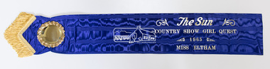
Photograph, Peter Pidgeon, The original Miss Eltham 1965 sash, 17 May 2019
My Recollections of Eltham Past by Margaret Joy Harding (nee Joy Chapman.) My family of Elizabeth and Alec Chapman moved to Eltham in 1946 into a cottage on the opposite side of the Diamond Creek from where the little train now operates in the Lower Park. At that time Eltham truly was a country town and the Pub was the main meeting place for most inhabitants on a Saturday afternoon in the beer garden. I attended Eltham Primary School where I started as a 4-year-old (my birthday being slightly after the mid-year intake) that happened then. My mother spent a lot of days taking me back to school when I had dismissed myself and walked the one kilomtre home alone. Bremner's Common (now Wingrove Park) was a big attraction with its dam and tad poling which I found much more entertaining than school. (Mrs Bremner ran a Service Station on the site of the current one). Another attraction at this site was the circus that came a couple of times a year. Watching them put up the circus tent was very interesting and even more of an attraction was the feeding of the Lions in cages and the monkeys and elephants among the other animals that are not found in a circus these days. At school then we were provided with hot chocolate at morning recess where the mothers would prepare it in the shelter shed. The only form of classroom heating was an open fire. Worse was the warm milk given in the summer months. By the time I was near finishing at Primary school we used to be able to walk along the Main Road at lunchtime to Mrs. Mitchell's shop to a delicious hot pie. As I recall there was no supervision for this departure from the school grounds. It is interesting that some of the other children I started school with I still have contact with, in fact one is a very good friend although now living in Perth. That is the other thing about Eltham; many who grew up here continue to live in the area. Following primary school, the natural progression was to Eltham High School. There was only the main building at that time and I can remember our first assembly at the front entrance. During the time I was at High School several new class rooms were added and the school hall. I remember the musical plays such as HMS Pinafore and other classical musicals being performed. I also remember countless hours doing marching practice. The main street shops when I was young consisted of the Blue Gum milk bar at the far end, a Grocery store and a shoe maker where Coles currently stands. Opposite there was Lyon's Garage. They also provided a bus service and when we got off the train this little bus would tour the back streets taking each individual to their home, sometimes this could take quite considerable time. There was also a Black Smith next to the Chiropractic Practice opposite Alistair Knox Park, another Milk Bar/General Store on the comer of Bridge Street/Main Road where a shop currently still operates. There was also a Butcher's shop down from the pub opposite Franklin Street. The only doctor was next to the courthouse on the other side of Brougham Street. On Saturday afternoon I was occasionally allowed to go the movies in the Town Hall which also stood on the site of the Coles centre. Often the Fire Alarm would sound and everyone would run outside to watch the fire truck leave with the volunteers clutching on the back. The other attraction during summer of course was the swimming pool which was a small concrete pool filled with water pumped from the Diamond Creek, sometimes it was like a mud puddle so for me the nearer to home Yarra/Diamond Creek junction was a much better option. We swam in the water hole which was quite deep and with fallen trees and sometimes carcasses of cows and kangaroos floating past. As recreation, the churches were another attraction for the Sunday school picnics to Mordialloc in the back of the moving van with benches tied into the back for us to "sit" on. Too bad when we went around a corner! In the early days we had an Ice Man deliver the ice once a week for "refrigeration". The green grocer came around in a horse and cart as did the milkman and the bread was delivered but I constantly got into trouble for eating the middle out on the way from the box it was delivered to in Mt Pleasant road across the paddock. The milkman finally would not come down our street after his horse bolted one morning and took off across the paddock. We also had the "Pan Man" come weekly and whose visit I would avoid. Our nearest shop was where the flower stall is located opposite the Lower Park. It consisted of a Tea Room and Milk Bar. There was a Public Telephone there which was the only contact to anyone else. We were a one car family so my mother’s movements were very limited as the Eltham Station was a couple of kilometres away and a trip to the city was an event. Being an only child growing up was a little lonely however rambling along the creek with my Mum, picking mushrooms and picking cherry plums for jam and the dogs catching rabbits which we ate if we could get them away from the dogs. We also liked to go into the Lower Park during school holidays when the Greek people came to camp and they would sing and dance around the camp fire and it all seemed so different to us as this was early days of immigration. Childhood was relatively simple and carefree and I wish the kids of today had the freedom of my youth and the healthy outdoor lifestyle of the "olden days". SHOW GIRL COMPETITION In 1965 Eltham was more like a country town than the suburb it has become today. People knew each other, if not personally then certainly of the family name. The big event for the year was a Gymkhana or show at Lower Eltham Park. I can remember marching as a teenager from the town centre to the park in the marching girls with the decorated floats. In 1965, just on a whim on the day, I decided to enter the Miss Eltham Show Girl which was a part of the festivities at the park. I seem to remember that the show mainly consisted of horse events, cattle judging and dog show. As I had not given any serious thought to entering the competition, I wore a suit that I had for work which was brown wool, with a coffee coloured shirt under, black shoes, bag, and gloves but no hat. I duly paraded for the judges and much to my surprise I was announced the winner. I eventually went on to compete at the Miss Victoria Show Girl competition which was held at the Royal Melbourne Show. There I met many country girls who were representing their rural Victoria home. I made it into a final round of judging but I think justice prevailed when someone from a country background was crowned. It was fun to go into the show as I had not really been before and to see the displays of handcraft, cooking and wood chopping events was great as well as the judging of farm animals interesting. It is hard to remember the Eltham I grew up in. The Lyons Garage company bus that actually drove you home (or close to it) when we got off the train at night. The Eltham Hotel on a Saturday afternoon a usual social meeting place where people just sat and chatted. The pictures held in the Town Hall and when the fire alarm sounded all the men just jumped up and ran to help. Suburbia has now swallowed most of that life but thankfully we at least do have the trestle bridge and parkland. Born digitalalec chapman, annie bremner, blacksmith, bremner's flat, brougham steet, bus services, circus, diamond creek, dianne bell, doctor bradbury, easter gymkhana, elizabeth chapman, eltham high school, eltham hotel, eltham lower park, eltham public hall, eltham state school, eltham trestle bridge, general store, grace mitchell, ice man, joy chapman, lyons garage, margaret harding, milk bar, miss eltham 1965, miss victoria show girl, mount pleasant road, pan man, rodda parade, shops, show girl competition, swimming pool, water hole, yarra river -
 Eltham District Historical Society Inc
Photograph, Joy Chapman in rear playground of Eltham High School, 1959, 1959
My Recollections of Eltham Past by Margaret Joy Harding (nee Joy Chapman.) My family of Elizabeth and Alec Chapman moved to Eltham in 1946 into a cottage on the opposite side of the Diamond Creek from where the little train now operates in the Lower Park. At that time Eltham truly was a country town and the Pub was the main meeting place for most inhabitants on a Saturday afternoon in the beer garden. I attended Eltham Primary School where I started as a 4-year-old (my birthday being slightly after the mid-year intake) that happened then. My mother spent a lot of days taking me back to school when I had dismissed myself and walked the one kilomtre home alone. Bremner's Common (now Wingrove Park) was a big attraction with its dam and tad poling which I found much more entertaining than school. (Mrs Bremner ran a Service Station on the site of the current one). Another attraction at this site was the circus that came a couple of times a year. Watching them put up the circus tent was very interesting and even more of an attraction was the feeding of the Lions in cages and the monkeys and elephants among the other animals that are not found in a circus these days. At school then we were provided with hot chocolate at morning recess where the mothers would prepare it in the shelter shed. The only form of classroom heating was an open fire. Worse was the warm milk given in the summer months. By the time I was near finishing at Primary school we used to be able to walk along the Main Road at lunchtime to Mrs. Mitchell's shop to a delicious hot pie. As I recall there was no supervision for this departure from the school grounds. It is interesting that some of the other children I started school with I still have contact with, in fact one is a very good friend although now living in Perth. That is the other thing about Eltham; many who grew up here continue to live in the area. Following primary school, the natural progression was to Eltham High School. There was only the main building at that time and I can remember our first assembly at the front entrance. During the time I was at High School several new class rooms were added and the school hall. I remember the musical plays such as HMS Pinafore and other classical musicals being performed. I also remember countless hours doing marching practice. The main street shops when I was young consisted of the Blue Gum milk bar at the far end, a Grocery store and a shoe maker where Coles currently stands. Opposite there was Lyon's Garage. They also provided a bus service and when we got off the train this little bus would tour the back streets taking each individual to their home, sometimes this could take quite considerable time. There was also a Black Smith next to the Chiropractic Practice opposite Alistair Knox Park, another Milk Bar/General Store on the comer of Bridge Street/Main Road where a shop currently still operates. There was also a Butcher's shop down from the pub opposite Franklin Street. The only doctor was next to the courthouse on the other side of Brougham Street. On Saturday afternoon I was occasionally allowed to go the movies in the Town Hall which also stood on the site of the Coles centre. Often the Fire Alarm would sound and everyone would run outside to watch the fire truck leave with the volunteers clutching on the back. The other attraction during summer of course was the swimming pool which was a small concrete pool filled with water pumped from the Diamond Creek, sometimes it was like a mud puddle so for me the nearer to home Yarra/Diamond Creek junction was a much better option. We swam in the water hole which was quite deep and with fallen trees and sometimes carcasses of cows and kangaroos floating past. As recreation, the churches were another attraction for the Sunday school picnics to Mordialloc in the back of the moving van with benches tied into the back for us to "sit" on. Too bad when we went around a corner! In the early days we had an Ice Man deliver the ice once a week for "refrigeration". The green grocer came around in a horse and cart as did the milkman and the bread was delivered but I constantly got into trouble for eating the middle out on the way from the box it was delivered to in Mt Pleasant road across the paddock. The milkman finally would not come down our street after his horse bolted one morning and took off across the paddock. We also had the "Pan Man" come weekly and whose visit I would avoid. Our nearest shop was where the flower stall is located opposite the Lower Park. It consisted of a Tea Room and Milk Bar. There was a Public Telephone there which was the only contact to anyone else. We were a one car family so my mother’s movements were very limited as the Eltham Station was a couple of kilometres away and a trip to the city was an event. Being an only child growing up was a little lonely however rambling along the creek with my Mum, picking mushrooms and picking cherry plums for jam and the dogs catching rabbits which we ate if we could get them away from the dogs. We also liked to go into the Lower Park during school holidays when the Greek people came to camp and they would sing and dance around the camp fire and it all seemed so different to us as this was early days of immigration. Childhood was relatively simple and carefree and I wish the kids of today had the freedom of my youth and the healthy outdoor lifestyle of the "olden days". SHOW GIRL COMPETITION In 1965 Eltham was more like a country town than the suburb it has become today. People knew each other, if not personally then certainly of the family name. The big event for the year was a Gymkhana or show at Lower Eltham Park. I can remember marching as a teenager from the town centre to the park in the marching girls with the decorated floats. In 1965, just on a whim on the day, I decided to enter the Miss Eltham Show Girl which was a part of the festivities at the park. I seem to remember that the show mainly consisted of horse events, cattle judging and dog show. As I had not given any serious thought to entering the competition, I wore a suit that I had for work which was brown wool, with a coffee coloured shirt under, black shoes, bag, and gloves but no hat. I duly paraded for the judges and much to my surprise I was announced the winner. I eventually went on to compete at the Miss Victoria Show Girl competition which was held at the Royal Melbourne Show. There I met many country girls who were representing their rural Victoria home. I made it into a final round of judging but I think justice prevailed when someone from a country background was crowned. It was fun to go into the show as I had not really been before and to see the displays of handcraft, cooking and wood chopping events was great as well as the judging of farm animals interesting. It is hard to remember the Eltham I grew up in. The Lyons Garage company bus that actually drove you home (or close to it) when we got off the train at night. The Eltham Hotel on a Saturday afternoon a usual social meeting place where people just sat and chatted. The pictures held in the Town Hall and when the fire alarm sounded all the men just jumped up and ran to help. Suburbia has now swallowed most of that life but thankfully we at least do have the trestle bridge and parkland. Digital file only - Black and white photo print on loan for scanning by EDHSalec chapman, annie bremner, blacksmith, bremner's flat, brougham steet, bus services, circus, diamond creek, dianne bell, doctor bradbury, easter gymkhana, elizabeth chapman, eltham high school, eltham hotel, eltham lower park, eltham public hall, eltham state school, eltham trestle bridge, general store, grace mitchell, ice man, joy chapman, lyons garage, margaret harding, milk bar, miss eltham 1965, miss victoria show girl, mount pleasant road, pan man, rodda parade, shops, show girl competition, swimming pool, water hole, yarra river -
 Eltham District Historical Society Inc
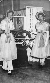
Photograph, Joy Chapman (left) with Dianne Bell in HMS Pinafore, 1960, 1960
My Recollections of Eltham Past by Margaret Joy Harding (nee Joy Chapman.) My family of Elizabeth and Alec Chapman moved to Eltham in 1946 into a cottage on the opposite side of the Diamond Creek from where the little train now operates in the Lower Park. At that time Eltham truly was a country town and the Pub was the main meeting place for most inhabitants on a Saturday afternoon in the beer garden. I attended Eltham Primary School where I started as a 4-year-old (my birthday being slightly after the mid-year intake) that happened then. My mother spent a lot of days taking me back to school when I had dismissed myself and walked the one kilomtre home alone. Bremner's Common (now Wingrove Park) was a big attraction with its dam and tad poling which I found much more entertaining than school. (Mrs Bremner ran a Service Station on the site of the current one). Another attraction at this site was the circus that came a couple of times a year. Watching them put up the circus tent was very interesting and even more of an attraction was the feeding of the Lions in cages and the monkeys and elephants among the other animals that are not found in a circus these days. At school then we were provided with hot chocolate at morning recess where the mothers would prepare it in the shelter shed. The only form of classroom heating was an open fire. Worse was the warm milk given in the summer months. By the time I was near finishing at Primary school we used to be able to walk along the Main Road at lunchtime to Mrs. Mitchell's shop to a delicious hot pie. As I recall there was no supervision for this departure from the school grounds. It is interesting that some of the other children I started school with I still have contact with, in fact one is a very good friend although now living in Perth. That is the other thing about Eltham; many who grew up here continue to live in the area. Following primary school, the natural progression was to Eltham High School. There was only the main building at that time and I can remember our first assembly at the front entrance. During the time I was at High School several new class rooms were added and the school hall. I remember the musical plays such as HMS Pinafore and other classical musicals being performed. I also remember countless hours doing marching practice. The main street shops when I was young consisted of the Blue Gum milk bar at the far end, a Grocery store and a shoe maker where Coles currently stands. Opposite there was Lyon's Garage. They also provided a bus service and when we got off the train this little bus would tour the back streets taking each individual to their home, sometimes this could take quite considerable time. There was also a Black Smith next to the Chiropractic Practice opposite Alistair Knox Park, another Milk Bar/General Store on the comer of Bridge Street/Main Road where a shop currently still operates. There was also a Butcher's shop down from the pub opposite Franklin Street. The only doctor was next to the courthouse on the other side of Brougham Street. On Saturday afternoon I was occasionally allowed to go the movies in the Town Hall which also stood on the site of the Coles centre. Often the Fire Alarm would sound and everyone would run outside to watch the fire truck leave with the volunteers clutching on the back. The other attraction during summer of course was the swimming pool which was a small concrete pool filled with water pumped from the Diamond Creek, sometimes it was like a mud puddle so for me the nearer to home Yarra/Diamond Creek junction was a much better option. We swam in the water hole which was quite deep and with fallen trees and sometimes carcasses of cows and kangaroos floating past. As recreation, the churches were another attraction for the Sunday school picnics to Mordialloc in the back of the moving van with benches tied into the back for us to "sit" on. Too bad when we went around a corner! In the early days we had an Ice Man deliver the ice once a week for "refrigeration". The green grocer came around in a horse and cart as did the milkman and the bread was delivered but I constantly got into trouble for eating the middle out on the way from the box it was delivered to in Mt Pleasant road across the paddock. The milkman finally would not come down our street after his horse bolted one morning and took off across the paddock. We also had the "Pan Man" come weekly and whose visit I would avoid. Our nearest shop was where the flower stall is located opposite the Lower Park. It consisted of a Tea Room and Milk Bar. There was a Public Telephone there which was the only contact to anyone else. We were a one car family so my mother’s movements were very limited as the Eltham Station was a couple of kilometres away and a trip to the city was an event. Being an only child growing up was a little lonely however rambling along the creek with my Mum, picking mushrooms and picking cherry plums for jam and the dogs catching rabbits which we ate if we could get them away from the dogs. We also liked to go into the Lower Park during school holidays when the Greek people came to camp and they would sing and dance around the camp fire and it all seemed so different to us as this was early days of immigration. Childhood was relatively simple and carefree and I wish the kids of today had the freedom of my youth and the healthy outdoor lifestyle of the "olden days". SHOW GIRL COMPETITION In 1965 Eltham was more like a country town than the suburb it has become today. People knew each other, if not personally then certainly of the family name. The big event for the year was a Gymkhana or show at Lower Eltham Park. I can remember marching as a teenager from the town centre to the park in the marching girls with the decorated floats. In 1965, just on a whim on the day, I decided to enter the Miss Eltham Show Girl which was a part of the festivities at the park. I seem to remember that the show mainly consisted of horse events, cattle judging and dog show. As I had not given any serious thought to entering the competition, I wore a suit that I had for work which was brown wool, with a coffee coloured shirt under, black shoes, bag, and gloves but no hat. I duly paraded for the judges and much to my surprise I was announced the winner. I eventually went on to compete at the Miss Victoria Show Girl competition which was held at the Royal Melbourne Show. There I met many country girls who were representing their rural Victoria home. I made it into a final round of judging but I think justice prevailed when someone from a country background was crowned. It was fun to go into the show as I had not really been before and to see the displays of handcraft, cooking and wood chopping events was great as well as the judging of farm animals interesting. It is hard to remember the Eltham I grew up in. The Lyons Garage company bus that actually drove you home (or close to it) when we got off the train at night. The Eltham Hotel on a Saturday afternoon a usual social meeting place where people just sat and chatted. The pictures held in the Town Hall and when the fire alarm sounded all the men just jumped up and ran to help. Suburbia has now swallowed most of that life but thankfully we at least do have the trestle bridge and parkland. Digital file only - Black and white photo print on loan for scanning by EDHSalec chapman, annie bremner, blacksmith, bremner's flat, brougham steet, bus services, circus, diamond creek, dianne bell, doctor bradbury, easter gymkhana, elizabeth chapman, eltham high school, eltham hotel, eltham lower park, eltham public hall, eltham state school, eltham trestle bridge, general store, grace mitchell, ice man, joy chapman, lyons garage, margaret harding, milk bar, miss eltham 1965, miss victoria show girl, mount pleasant road, pan man, rodda parade, shops, show girl competition, swimming pool, water hole, yarra river -
 Eltham District Historical Society Inc
Photograph, Rodda Parade looking towards the creek, 1960. Chapman home to the right, 1960
My Recollections of Eltham Past by Margaret Joy Harding (nee Joy Chapman.) My family of Elizabeth and Alec Chapman moved to Eltham in 1946 into a cottage on the opposite side of the Diamond Creek from where the little train now operates in the Lower Park. At that time Eltham truly was a country town and the Pub was the main meeting place for most inhabitants on a Saturday afternoon in the beer garden. I attended Eltham Primary School where I started as a 4-year-old (my birthday being slightly after the mid-year intake) that happened then. My mother spent a lot of days taking me back to school when I had dismissed myself and walked the one kilomtre home alone. Bremner's Common (now Wingrove Park) was a big attraction with its dam and tad poling which I found much more entertaining than school. (Mrs Bremner ran a Service Station on the site of the current one). Another attraction at this site was the circus that came a couple of times a year. Watching them put up the circus tent was very interesting and even more of an attraction was the feeding of the Lions in cages and the monkeys and elephants among the other animals that are not found in a circus these days. At school then we were provided with hot chocolate at morning recess where the mothers would prepare it in the shelter shed. The only form of classroom heating was an open fire. Worse was the warm milk given in the summer months. By the time I was near finishing at Primary school we used to be able to walk along the Main Road at lunchtime to Mrs. Mitchell's shop to a delicious hot pie. As I recall there was no supervision for this departure from the school grounds. It is interesting that some of the other children I started school with I still have contact with, in fact one is a very good friend although now living in Perth. That is the other thing about Eltham; many who grew up here continue to live in the area. Following primary school, the natural progression was to Eltham High School. There was only the main building at that time and I can remember our first assembly at the front entrance. During the time I was at High School several new class rooms were added and the school hall. I remember the musical plays such as HMS Pinafore and other classical musicals being performed. I also remember countless hours doing marching practice. The main street shops when I was young consisted of the Blue Gum milk bar at the far end, a Grocery store and a shoe maker where Coles currently stands. Opposite there was Lyon's Garage. They also provided a bus service and when we got off the train this little bus would tour the back streets taking each individual to their home, sometimes this could take quite considerable time. There was also a Black Smith next to the Chiropractic Practice opposite Alistair Knox Park, another Milk Bar/General Store on the comer of Bridge Street/Main Road where a shop currently still operates. There was also a Butcher's shop down from the pub opposite Franklin Street. The only doctor was next to the courthouse on the other side of Brougham Street. On Saturday afternoon I was occasionally allowed to go the movies in the Town Hall which also stood on the site of the Coles centre. Often the Fire Alarm would sound and everyone would run outside to watch the fire truck leave with the volunteers clutching on the back. The other attraction during summer of course was the swimming pool which was a small concrete pool filled with water pumped from the Diamond Creek, sometimes it was like a mud puddle so for me the nearer to home Yarra/Diamond Creek junction was a much better option. We swam in the water hole which was quite deep and with fallen trees and sometimes carcasses of cows and kangaroos floating past. As recreation, the churches were another attraction for the Sunday school picnics to Mordialloc in the back of the moving van with benches tied into the back for us to "sit" on. Too bad when we went around a corner! In the early days we had an Ice Man deliver the ice once a week for "refrigeration". The green grocer came around in a horse and cart as did the milkman and the bread was delivered but I constantly got into trouble for eating the middle out on the way from the box it was delivered to in Mt Pleasant road across the paddock. The milkman finally would not come down our street after his horse bolted one morning and took off across the paddock. We also had the "Pan Man" come weekly and whose visit I would avoid. Our nearest shop was where the flower stall is located opposite the Lower Park. It consisted of a Tea Room and Milk Bar. There was a Public Telephone there which was the only contact to anyone else. We were a one car family so my mother’s movements were very limited as the Eltham Station was a couple of kilometres away and a trip to the city was an event. Being an only child growing up was a little lonely however rambling along the creek with my Mum, picking mushrooms and picking cherry plums for jam and the dogs catching rabbits which we ate if we could get them away from the dogs. We also liked to go into the Lower Park during school holidays when the Greek people came to camp and they would sing and dance around the camp fire and it all seemed so different to us as this was early days of immigration. Childhood was relatively simple and carefree and I wish the kids of today had the freedom of my youth and the healthy outdoor lifestyle of the "olden days". SHOW GIRL COMPETITION In 1965 Eltham was more like a country town than the suburb it has become today. People knew each other, if not personally then certainly of the family name. The big event for the year was a Gymkhana or show at Lower Eltham Park. I can remember marching as a teenager from the town centre to the park in the marching girls with the decorated floats. In 1965, just on a whim on the day, I decided to enter the Miss Eltham Show Girl which was a part of the festivities at the park. I seem to remember that the show mainly consisted of horse events, cattle judging and dog show. As I had not given any serious thought to entering the competition, I wore a suit that I had for work which was brown wool, with a coffee coloured shirt under, black shoes, bag, and gloves but no hat. I duly paraded for the judges and much to my surprise I was announced the winner. I eventually went on to compete at the Miss Victoria Show Girl competition which was held at the Royal Melbourne Show. There I met many country girls who were representing their rural Victoria home. I made it into a final round of judging but I think justice prevailed when someone from a country background was crowned. It was fun to go into the show as I had not really been before and to see the displays of handcraft, cooking and wood chopping events was great as well as the judging of farm animals interesting. It is hard to remember the Eltham I grew up in. The Lyons Garage company bus that actually drove you home (or close to it) when we got off the train at night. The Eltham Hotel on a Saturday afternoon a usual social meeting place where people just sat and chatted. The pictures held in the Town Hall and when the fire alarm sounded all the men just jumped up and ran to help. Suburbia has now swallowed most of that life but thankfully we at least do have the trestle bridge and parkland. Digital file only - Black and white photo print on loan for scanning by EDHSalec chapman, annie bremner, blacksmith, bremner's flat, brougham steet, bus services, circus, diamond creek, dianne bell, doctor bradbury, easter gymkhana, elizabeth chapman, eltham high school, eltham hotel, eltham lower park, eltham public hall, eltham state school, eltham trestle bridge, general store, grace mitchell, ice man, joy chapman, lyons garage, margaret harding, milk bar, miss eltham 1965, miss victoria show girl, mount pleasant road, pan man, rodda parade, shops, show girl competition, swimming pool, water hole, yarra river -
 Eltham District Historical Society Inc
Photograph, Joy Chapman at the river junction, February 1962, Feb 1962
My Recollections of Eltham Past by Margaret Joy Harding (nee Joy Chapman.) My family of Elizabeth and Alec Chapman moved to Eltham in 1946 into a cottage on the opposite side of the Diamond Creek from where the little train now operates in the Lower Park. At that time Eltham truly was a country town and the Pub was the main meeting place for most inhabitants on a Saturday afternoon in the beer garden. I attended Eltham Primary School where I started as a 4-year-old (my birthday being slightly after the mid-year intake) that happened then. My mother spent a lot of days taking me back to school when I had dismissed myself and walked the one kilomtre home alone. Bremner's Common (now Wingrove Park) was a big attraction with its dam and tad poling which I found much more entertaining than school. (Mrs Bremner ran a Service Station on the site of the current one). Another attraction at this site was the circus that came a couple of times a year. Watching them put up the circus tent was very interesting and even more of an attraction was the feeding of the Lions in cages and the monkeys and elephants among the other animals that are not found in a circus these days. At school then we were provided with hot chocolate at morning recess where the mothers would prepare it in the shelter shed. The only form of classroom heating was an open fire. Worse was the warm milk given in the summer months. By the time I was near finishing at Primary school we used to be able to walk along the Main Road at lunchtime to Mrs. Mitchell's shop to a delicious hot pie. As I recall there was no supervision for this departure from the school grounds. It is interesting that some of the other children I started school with I still have contact with, in fact one is a very good friend although now living in Perth. That is the other thing about Eltham; many who grew up here continue to live in the area. Following primary school, the natural progression was to Eltham High School. There was only the main building at that time and I can remember our first assembly at the front entrance. During the time I was at High School several new class rooms were added and the school hall. I remember the musical plays such as HMS Pinafore and other classical musicals being performed. I also remember countless hours doing marching practice. The main street shops when I was young consisted of the Blue Gum milk bar at the far end, a Grocery store and a shoe maker where Coles currently stands. Opposite there was Lyon's Garage. They also provided a bus service and when we got off the train this little bus would tour the back streets taking each individual to their home, sometimes this could take quite considerable time. There was also a Black Smith next to the Chiropractic Practice opposite Alistair Knox Park, another Milk Bar/General Store on the comer of Bridge Street/Main Road where a shop currently still operates. There was also a Butcher's shop down from the pub opposite Franklin Street. The only doctor was next to the courthouse on the other side of Brougham Street. On Saturday afternoon I was occasionally allowed to go the movies in the Town Hall which also stood on the site of the Coles centre. Often the Fire Alarm would sound and everyone would run outside to watch the fire truck leave with the volunteers clutching on the back. The other attraction during summer of course was the swimming pool which was a small concrete pool filled with water pumped from the Diamond Creek, sometimes it was like a mud puddle so for me the nearer to home Yarra/Diamond Creek junction was a much better option. We swam in the water hole which was quite deep and with fallen trees and sometimes carcasses of cows and kangaroos floating past. As recreation, the churches were another attraction for the Sunday school picnics to Mordialloc in the back of the moving van with benches tied into the back for us to "sit" on. Too bad when we went around a corner! In the early days we had an Ice Man deliver the ice once a week for "refrigeration". The green grocer came around in a horse and cart as did the milkman and the bread was delivered but I constantly got into trouble for eating the middle out on the way from the box it was delivered to in Mt Pleasant road across the paddock. The milkman finally would not come down our street after his horse bolted one morning and took off across the paddock. We also had the "Pan Man" come weekly and whose visit I would avoid. Our nearest shop was where the flower stall is located opposite the Lower Park. It consisted of a Tea Room and Milk Bar. There was a Public Telephone there which was the only contact to anyone else. We were a one car family so my mother’s movements were very limited as the Eltham Station was a couple of kilometres away and a trip to the city was an event. Being an only child growing up was a little lonely however rambling along the creek with my Mum, picking mushrooms and picking cherry plums for jam and the dogs catching rabbits which we ate if we could get them away from the dogs. We also liked to go into the Lower Park during school holidays when the Greek people came to camp and they would sing and dance around the camp fire and it all seemed so different to us as this was early days of immigration. Childhood was relatively simple and carefree and I wish the kids of today had the freedom of my youth and the healthy outdoor lifestyle of the "olden days". SHOW GIRL COMPETITION In 1965 Eltham was more like a country town than the suburb it has become today. People knew each other, if not personally then certainly of the family name. The big event for the year was a Gymkhana or show at Lower Eltham Park. I can remember marching as a teenager from the town centre to the park in the marching girls with the decorated floats. In 1965, just on a whim on the day, I decided to enter the Miss Eltham Show Girl which was a part of the festivities at the park. I seem to remember that the show mainly consisted of horse events, cattle judging and dog show. As I had not given any serious thought to entering the competition, I wore a suit that I had for work which was brown wool, with a coffee coloured shirt under, black shoes, bag, and gloves but no hat. I duly paraded for the judges and much to my surprise I was announced the winner. I eventually went on to compete at the Miss Victoria Show Girl competition which was held at the Royal Melbourne Show. There I met many country girls who were representing their rural Victoria home. I made it into a final round of judging but I think justice prevailed when someone from a country background was crowned. It was fun to go into the show as I had not really been before and to see the displays of handcraft, cooking and wood chopping events was great as well as the judging of farm animals interesting. It is hard to remember the Eltham I grew up in. The Lyons Garage company bus that actually drove you home (or close to it) when we got off the train at night. The Eltham Hotel on a Saturday afternoon a usual social meeting place where people just sat and chatted. The pictures held in the Town Hall and when the fire alarm sounded all the men just jumped up and ran to help. Suburbia has now swallowed most of that life but thankfully we at least do have the trestle bridge and parkland. Digital file only - Black and white photo print on loan for scanning by EDHSalec chapman, annie bremner, blacksmith, bremner's flat, brougham steet, bus services, circus, diamond creek, dianne bell, doctor bradbury, easter gymkhana, elizabeth chapman, eltham high school, eltham hotel, eltham lower park, eltham public hall, eltham state school, eltham trestle bridge, general store, grace mitchell, ice man, joy chapman, lyons garage, margaret harding, milk bar, miss eltham 1965, miss victoria show girl, mount pleasant road, pan man, rodda parade, shops, show girl competition, swimming pool, water hole, yarra river -
 Eltham District Historical Society Inc
Document, Russell Yeoman, Tour of Historic Buildings and Locations, 1978
Self guided heritage tour information produced by the Shire of Eltham Historical Society for 1978 Eltham Community Festival of 36 locations each numbered on accompanying map. Locations and detail provided current to 1978: 1. ELTHAM SHOPPING CENTRE Whilst very little remains in the centre of historical importance, this area has interest as the "village" which developed over many years following the opening of the railway from Melbourne in 1902. Previously the shopping centre had been spread out over a long length of Main Road to the south. Shops have been continuously demolished or remodelled and the majority of buildings date from the 1950's or later. The recently erected Post Office replaced the "old" Post Office opened on the same site only in 1958. 2. WOOLWORTHS ELTHAM VILLAGE Part of the site of this modern shopping development was occupied by the former Eltham Shire Offices and Hall. The hall was paid for by public subscription whilst the Council raised a loan for the offices. The combined building was opened in 1941. It served as office and Council meeting place until 1965 and as the hall until its demolition in 1970. 3. ELTHAM WAR MEMORIAL The complex of buildings adjoining the present Shire Offices were financed by public subscription as a Memorial following World War II. Their construction and for many years their operation was organised by the now disbanded Eltham War Memorial Committee. The original buildings were the; Infant Welfare Centre, Children’s Library (now War Memorial Hall and Dental Clinic) and Kindergarten. In later years the Elderly Citizens Club was built at the rear. 4. ELTHAM SHIRE OFFICES These offices were opened in 1965 and extended in 1971 to provide additional office accommodation and the Eltham Library. They represent the last of a long line of offices and meeting places of the Eltham Shire Council and its predecessor the Eltham District Road Board. The building occupies the former site of Shillinglaw Cottage. The three tall cypress trees which stood in front of the Cottage have been retained as a feature of the office surrounds. 5. OUR LADY'S CHURCH AND SCHOOL The Catholic Church and School complex opposite the Shires Offices shows a number of stages in the development of Eltham township. The recently constructed church adjoins its predecessor (now the parish centre). Many years ago the Catholic Church was located opposite Wingrove Park and the present central site follows the northerly drift of the township. 6. SHILLINGLAW COTTAGE The Cottage was built in 1859 by George Stebbing, a local builder who was responsible for a number of other prominent buildings in the area. Its removal from the site of the Shire Offices and re-erection on the present site was financed by public subscription. It is built of handmade bricks laid in Flemish Bond with an unusual design featuring burnt "leader" bricks over the whole facade. The Cottage is occupied by Eltham Fleececrafts and will be open during the Festival and at other times during weekends. It is classified by the National Trust. 7. RAILWAY BRIDGE The timber trestle bridge over the Diamond Creek was built in 1901. Whilst all of its timbers have been replaced at various times over the years the only change to its character has been the addition of pylons and wiring for electric trains in 1923. It is one of very few similar bridges remaining in the metropolitan area. In 1976 a proposal to replace the bridge with an earth embankment and large culvert pipes was abandoned following community protests. The bridge, however, remains under threat because of the necessity for future deuplication of the railway line. 8. ELTHAM CENTPAL PARK The area between the railway and the creek has for many years been used as a park which included Eltham' s main football oval. The access road, Panther Place is named after Eltham's team playing in the Diamond Valley League. In recent years a large area extending to Bridge Street and locally known as the Town Park has been landscaped and added to the area. The excellent blending of the park with the natural landscape of the creek valley has earned a National Trust Landscape Classification. 9. OLD BAKERY On the southern corner of York Street and Main Road is an old house with a shop front which was for many years the local baker's shop. The brick bakery at the rear is of somewhat later vintage than the house. 10. BRIDGE STREET CUTTING Before reconstruction of Main Road this intersection had deep cutting embankments on all four corners, forming a distinctive feature of the entrance to Eltham. Roadworks and private development have levelled the land on the low side of the road. A memorial to the Eltham soldiers of World War I which was located at the north-western corner is now situated at the Eltham R.S.L. 11. HILLTOP MILK BAR For many years this was the site of the Eltham Post Office under the control of the Hunniford family and later their descendants the Burgoynes. It was transferred to this site in 1855, although at that time the building apparently fronted Bridge Str e et. The site contained Eltham's first telephone exchange. The post office was relocated in 1954 but the shop was operated until recently by the Burgoyne family who still own the surrounding land. 12. UNITING CHURCH and former C.B.A. BANK The former Methodist Church was built in 1880 by George Stebbing. The Sunday School extension was built in 1929 and there have been more recent extensions. The adjoining opportunity shop was built as a bank in 1874 and purchased by the Methodist Church in 1954. 13. R.S.L. HALL, TELEPHONE EXCHANGE These relatively recent buildings occupy the site of a row of shops forming part of the early ribbon of business development along Main Road. In front of the R.S.L. building is the World War I Memorial relocated from the corner of Bridge Street and Main Road. 14. ELTHAM COMMUNITY CENTRE Australia's first mudbrick "community building" was opened in April this year. Part of the site of the building was purchased in 1856 by Henry Dendy (of Brighton fame). At the rear of the land near the creek was a steam flour mill whilst Dendy's house was at the Main Road frontage of the land. His purchase totalled about 2 Ha (5 acres) and included land on the opposite side of Maria Street (Main Road). Dendy became a prominent member of the Eltham community and served one term as President of the Eltham District Road Board. In 1867 Dendy sold his land and business to William Ford of Malmsbury and shifted to Walhalla. The avenue of trees leading past the Community Centre to the creek may well have bordered the track to the mill. 15. ELTHAM HOTEL The original part of this hotel was built in 1927 following the burning of the former Watson's Eltham Hotel on the same site. The car park on the opposite side of Main Road was also the site of a hotel variously known over the years as; the Fountain of Friendship, the Fountain and the Evelyn Arms. As the Fountain of Friendship it was the first meeting place of the Eltham District Road Board in 1856. 16. ST. MARGARET'S CHURCH, PITT STREET In 1860 Henry Dendy was appointed Chairman of a committee to establish a church of England in Eltham. He donated part of his land in Pitt Street and in 1861 the church was opened. It was built by George Stebbing and remains in a well preserved state today. Th adjoining old vicarage is now named Dendy Hou se. A new mudbrick church hall is under construction on the site. The church and Dendy House are now listed on the Register of Historic Buildings. 17. NO. 86 PITT STREET Cottage built by George Stebbing and believed to be his home for some years in the 1850s. 18. LIVING AND LEARNING CENTRE The house was built in the 1850s with the kitchen at the front being added about 40 years later. By the creek below the house a number of early Eltham industries were located. These included a tannery and a brewery. 19. ELTHAM COURT HOUSE A Court of Petty Sessions was established in Eltham in 1858 and the present building dates from 1860. It is the oldest public building remaining in Eltham. In its early days the building was used as the meeting place and office of the Eltham District Road Board and as an overflow classroom for the local school. The Court House has been classified by the National Trust. The citation states that it is an example of the simple form of early brick Court House with gabled roof and porch. 20. LANDS DEPARTMENT OFFICE This building is the former police station and is probably of about the same age as the Court House. The lockup at the rear has been demolished but the old stables remain as garages. A licence was first granted for a police station at Eltham in 1856. 21. JARROLD COTTAGE The old Cottage opposite Dalton Street was formerly owned by the Jarrold family. Early records indicate that this was the building leased from the Jarrolds as a temporary police station prior to construction of the building on the corner of Brougham Street. The small building on the corner of the property was used as a boot repairer's shop. The elevated studio at the rear is a more recent construction by the present owners. 22. STATE SCHOOL RESIDENCE Erected in 1891 23. WINGROVE COTTAGE This building fills an important place in the history of Eltham and is now used as a medical clinic. It was built in 1858 for Charles S. Wingrove who was Secretary to the Eltham District Road Board and Shire Council from 1858 to 1904. During part of this period he was also Shire Engineer and was Secretary to the Heidelberg Road Board. The house was used as the office of the Board and Council for many years. Wingrove is buried in the cemetery at St. Helena. 24. WINGROVE PARK The parkland opposite Wingrove Cottage has been named after Charles Wingrove. The old Manna Gums are an outstanding feature of the park. 25. ELTHAM FRI.MARY SCHOOL NO. 209 The school first opened in the slab building in 1855 and operated from the present site since 1857. The oldest part of the present school is the stone building erected in 1876. The first school teacher, David Clark remained at the school until 1888. This school is the government township and has always been known as the Eltham School. An earlier school (no.371) known as Little Eltham School operated in Swan Street from 1853 to 1872. 26. "SHOESTRING" This house was built for school teacher David Clark. It has been extensively extended in recent years but the extensions do not detract from the character of the older part of the building. 27. ELTHAM CEMETERY The cemetery contains the graves of many of the district's pioneers . 28. MONTSALVAT This unique complex of buildings was commenced in 1935 by the late Justus Jorgensen and its development has extended over many years. Montsalvat has exerted a significant impact on Eltham The earth and stone construction of many of the buildings has influenced local architecture to a great extent and it has served as a "nerve centre" of the local artistic community. Montsalvat is open to the public for a small charge. 29. MAIN ROAD BRIDGE This location has been the main crossing of Diamond Creek since the earliest days of settlement. The present concrete bridge was erected in 1925 .and was preceded by a number of timber bridges. 30. ELTHAM LOWER PARK This park, being an unusually large flat area for Eltham, was originally the local racecourse. Horse races were held here from 1855 and the area was gazetted as a reserve for a racecourse and recreation reserve in 1857. The park is well known as a venue for school "bird days" and more recently as the site of the Diamond Valley Railway. This miniature railway features scale models of modern and old locomotives and rolling stock and has operated on this site since 1961 . Before that the railway operated at Chelsworth Park, Ivanhoe. 31. FALKINER HOUSE Frederick Falkiner was one of the earliest settlers in the Eltham township area and occupied a substantial leasehold prior to the first land sales. Early records show that Falkiner was the subject of a number of complaints from his neighbours but he has nevertheless been considered a prominent enough citizen to have a street named for him. This house was the home of Evelyn (Ely) Falkiner a member of Frederick's family. 32. WEST HOUSE Behind the large house on the hill is an early house built by the West family. This was relocated from a site near the front of the land by the present owner Mr. Fabbro. 33. FALKINER HOUSE This very old house is believed to have been the home of Frederick and may have been Eltham's first post office. Falkiner was the first post master for a short period. in 1854/55. 34. WITHERS HOUSE This house was the home of famous artist Walter Withers who shifted here from Heidelberg in 1903. 35. ELTHAM HIGH SCHOOL This school celebrated its jubilee this year, having commenced as the Eltham Higher Elementary School 50 years ago. 36. DIAMOND CREEK FOOTWAY If returning from the High School to the town centre the footpath by the bank of the Diamond Creek provides a pleasant route to finish your walk. The creek is a major tributary of the Yarra River. Together with its own major tributaries Arthurs Creek and Running Creek it commences on the southern slopes of the Dividing Range at Kinglake. It gives the name Diamond Valley to an area extending well beyond its actual drainage catchment.Recognition of the significance of various landmarks to the history of the Eltham community as of 1978‘shoestring’, 1978, bridge street cutting, burgoyne store, c.b.a. bank, diamond creek trail, eltham cemetery, eltham central park, eltham community centre, eltham community festival, eltham court house, eltham festival, eltham high school, eltham hotel, eltham lower park, eltham primary school, eltham railway trestle bridge, eltham shire offices, eltham shopping centre, eltham state school no. 209, eltham village, eltham war memorial, falkiner house, heritage trail, hilltop milk bar, jarrold cottage, lands department office, living, living and learning centre, main road bridge, montsalvat, old bakery, our eltham artistic recollections, our lady help of christian’s church, our lady help of christian’s primary school, pitt street, post office, r.s.l. hall, shillinglaw cottage, st margaret’s church, state school residence, stebbing cottage, telephone exchange, uniting church, west house, wingrove cottage, wingrove park, withers house, woolworths -
 Eltham District Historical Society Inc
Photograph, Fay Bridge, Eltham Craft & Produce Market, Library Place, Eltham, n.d
fay bridge collection, eltham, eltham craft & produce market, eltham market, eltham railway trestle bridge, library place -
 Eltham District Historical Society Inc
Photograph (Item) - Negative, Samantha Robertson, Eltham Community Photographic Survey Entry, 1988
Samantha Robertson 1988 Entrant No. 1 Ref: Series 34 Items 1, 2, 42-45 The images in this record were not selected for inclusion. SHIRE OF ELTHAM COMMUNITY PHOTOGRAPHIC SURVEY Photography is an artform which many of us practice, sometimes purely for artistic pursuit, sometimes to record the people and events in our lives. In 1988, as part of a local Bicentennial project, the Shire of Eltham conducted the Eltham Community Photographic Survey. Up to 100 entries were to be selected by a panel of photographers for entry into the Eltham Photographic Survey Exhibition. Entries had to be submitted by May 13, 1988. Entrants whose images were selected for the exhibition were contacted and requested to further submit an entry form providing entrant’s name, area of residence, age, and proposed captions. These details were then used to produce labels for the exhibition mounts. Where negatives had not been supplied, these were requested to support the display of printed enlargements mounted on 10” x 8” cardboard. The mounted prints were made available post exhibition for sale at $8.50 each for colour prints and $7.00 for B&W prints. Residents in the Shire were invited to collect a free roll of film and take a photograph of what they either liked or did not like about the area. A total of 160 entrants submitted multiple entries for the exhibition. Of those selected for exhibition, entrants ranged in age from 9 to 70 years. All custom colour and black and white printing for the exhibition was completed by Wattle Studios of Eltham. The Eltham Photographic Survey was jointly auspiced by the Shire of Eltham and Wattle Studios, of 953 Main Road, Eltham. The project was greatly assisted by: • David McRitchie, Media Studies Lecturer Victoria College, Rusden Campus. • Ian and Annette Toohill of Wattle Studios • Tracy Naughton, Eltham Community Arts Officer • Neville Emerson Pty. Ltd. • Superior Press, Eltham • Kodak Australasia Pty. Ltd. • Agfa Gevaert Ltd. • Townsend Colourtech Pty. Ltd. • The Australian Bicentennial Authority • Eleanor Bowers, Secretary, Eltham Arts Council The exhibition was placed on display in the Woolworths Arcade, Eltham between Monday June 6th and Saturday June 11, 1988. It was also intended to hold the exhibition at a venue in the Shire’s North Riding from Monday, June 20 to Friday June 24. It was then displayed at the Were Street Theatre, Montmorency from Friday, June 24 to Thursday, July 7. Series 34: Eltham Community Photographic Survey 1988 - Prints & Documentation Series consists of 117 photographs of Shire scenes taken by members of the community. Items I - 41 are larger photographs mounted on card, which were exhibited. Items 42 - 117 are unmounted copies, alternative takes and other entries. Corresponding negatives contained in Series 35: Eltham Community Photographic Survey 1988 – Negatives which consists of 267 colour and B&W negatives and one colour slide of Shire scenes taken by members of the community. The negatives are arranged by the entrant number of the photographer. The Eltham Community Photographic Survey collection is significant to the local community as it was curated by the local community - ordinary people of all ages - representing what they liked and did not like in the area where they lived. It represents an unfiltered representation of the Shire of Eltham as it was in 1988. It also represents one of many projects as part of the national programme of events and celebrations to commemorate the bicentenary. It is a time capsule of life in the 1980s of this urban and rural municipality in Melbourne's north. shire of eltham archives, bicentennial project, eltham, eltham community photographic survey, samantha robertson, series 35, film - ilford xp1 400, scan - 35mm negative, sundial, eltham trestle bridge, central park, panther place, graffiti, eltham senior citizens centre, eltham shire office, eucalyptus tree, main road, sign, arthur street, commercial place, eltham village, safeway carpark -
 Eltham District Historical Society Inc
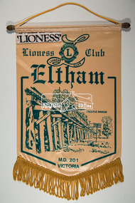
Banner, Lioness Club Eltham, M.D. 201 Victoria
banners, lioness club eltham, trestle bridge -
 Eltham District Historical Society Inc
Photograph (Item) - Negative, Nicholas West, Eltham Community Photographic Survey Entry, 1988
Nicholas West 1988 Entrant No. 66 Ref: Series 34, Items 82-86 The images in this record were not selected for inclusion. SHIRE OF ELTHAM COMMUNITY PHOTOGRAPHIC SURVEY Photography is an artform which many of us practice, sometimes purely for artistic pursuit, sometimes to record the people and events in our lives. In 1988, as part of a local Bicentennial project, the Shire of Eltham conducted the Eltham Community Photographic Survey. Up to 100 entries were to be selected by a panel of photographers for entry into the Eltham Photographic Survey Exhibition. Entries had to be submitted by May 13, 1988. Entrants whose images were selected for the exhibition were contacted and requested to further submit an entry form providing entrant’s name, area of residence, age, and proposed captions. These details were then used to produce labels for the exhibition mounts. Where negatives had not been supplied, these were requested to support the display of printed enlargements mounted on 10” x 8” cardboard. The mounted prints were made available post exhibition for sale at $8.50 each for colour prints and $7.00 for B&W prints. Residents in the Shire were invited to collect a free roll of film and take a photograph of what they either liked or did not like about the area. A total of 160 entrants submitted multiple entries for the exhibition. Of those selected for exhibition, entrants ranged in age from 9 to 70 years. All custom colour and black and white printing for the exhibition was completed by Wattle Studios of Eltham. The Eltham Photographic Survey was jointly auspiced by the Shire of Eltham and Wattle Studios, of 953 Main Road, Eltham. The project was greatly assisted by: • David McRitchie, Media Studies Lecturer Victoria College, Rusden Campus. • Ian and Annette Toohill of Wattle Studios • Tracy Naughton, Eltham Community Arts Officer • Neville Emerson Pty. Ltd. • Superior Press, Eltham • Kodak Australasia Pty. Ltd. • Agfa Gevaert Ltd. • Townsend Colourtech Pty. Ltd. • The Australian Bicentennial Authority • Eleanor Bowers, Secretary, Eltham Arts Council The exhibition was placed on display in the Woolworths Arcade, Eltham between Monday June 6th and Saturday June 11, 1988. It was also intended to hold the exhibition at a venue in the Shire’s North Riding from Monday, June 20 to Friday June 24. It was then displayed at the Were Street Theatre, Montmorency from Friday, June 24 to Thursday, July 7. Series 34: Eltham Community Photographic Survey 1988 - Prints & Documentation Series consists of 117 photographs of Shire scenes taken by members of the community. Items I - 41 are larger photographs mounted on card, which were exhibited. Items 42 - 117 are unmounted copies, alternative takes and other entries. Corresponding negatives contained in Series 35: Eltham Community Photographic Survey 1988 – Negatives which consists of 267 colour and B&W negatives and one colour slide of Shire scenes taken by members of the community. The negatives are arranged by the entrant number of the photographer. The Eltham Community Photographic Survey collection is significant to the local community as it was curated by the local community - ordinary people of all ages - representing what they liked and did not like in the area where they lived. It represents an unfiltered representation of the Shire of Eltham as it was in 1988. It also represents one of many projects as part of the national programme of events and celebrations to commemorate the bicentenary. It is a time capsule of life in the 1980s of this urban and rural municipality in Melbourne's north. shire of eltham archives, bicentennial project, eltham, eltham community photographic survey, series 35, film - kodak gb 200 5096, nicholas west, scan - 35mm negative, trees, alistair knox park, eltham common, eltham town park, shillinglaw cottage, bridge street bridge, central park, eltham trestle bridge, alsatian (dog), council pound, german shepherd (dog) -
 Eltham District Historical Society Inc
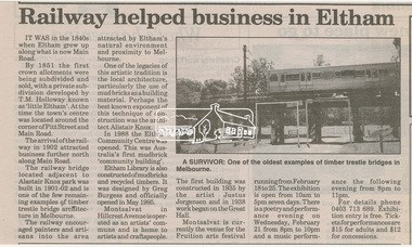
Newsclipping, Railway helped business in Eltham, Diamond Valley News(?)
Digital file only - Digitised by EDHS from a scrapbook on loan from Beryl Bradbury (nee Stokes), daughter of Frank Stokes.beryl bradbury (nee stokes) collection, eltham community centre, eltham library, little eltham, montsalvat, railway line, t.m. holloway, trestle bridge -
 Eltham District Historical Society Inc
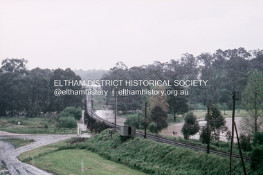
Slide, Floodwater, Eltham Central Park, November 1971, 1971
35 mm colour positive transparency Mount - Agfacolor Service (Blue)eltham, eltham central park, eltham trestle bridge, floods, trestle bridge -
 Eltham District Historical Society Inc
Book, Diamond Creek Basin Study. Part 1, A Compendium of Factors Relevant to Stormwater Flows, 1980
Basin Studies are studies to evaluate water supply and demand and help ensure reliable water supplies by identifying strategies to address imbalances in water supply and demand.Spiral Bound. 157 leaves in various foliations (some folded) : illustrated. (some colour.), maps (some colour.)aerial photographs, allendale road, arthurs creek mine, arthurs creek road bridge, arthurs creek, bald spur look-out, bank protection, bolton steet, bridge street bridge, bridge street, bridges, challenger street, chute street, construction, coolaroo drive, culvert, deep creek, diamond creek basin, diamond creek region, diamond creek, diamond street bridge, drainage works, eltham lower park, eltham town park, eltham trestle bridge, eltham west drains, eltham, erosion, flood management, floods, footbridge, glen katherine estate, gold mining, gum glade, hurstbridge, kangaroo ground, kinglake escarpment, kinglake national park, latiners hat factory, main road bridge, main road, masons falls, melbourne metropolitan board of works, monash bridge, mount sugarloaf, nillumbik park, orchards, railway culvert, railway line, ramptons road, real estate advertisement, research creek, st helena east drain, st helena road, st helena, storm sewers, stormwater, sugarloaf-preston transfer main crossing, susan street, union mine, village pond, water flow, watkins street, wattletree road, weidlich road, wingrove park, yarra river, zig zag road, water supply, basin study -
 Marysville & District Historical Society
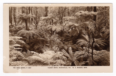
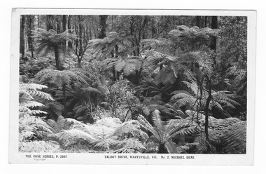
Postcard (item) - Black and white postcard, Rose Stereograph Company, Talbot Drive, Marysville, Vic. No. 2, Michael Dene, 1913-1967
A postcard in a series produced by the Rose Stereograph Company in Victoria, Australia as a souvenir of Marysville.A black and white photograph showing trees and tree ferns, taken along the Michaeldene Trail near Lady Talbot Drive in Marysville in Victoria. The Michaeldene Trail is a level two loop that leads to the Taggerty River Lookout and may be undertaken as either as a Short (2.7 km) Loop, or a Long (4.3 km) Loop - 30 minutes to one hour and a half. The attractive bushland linking the Steavenson and Taggerty Rivers allows walkers and cyclists to step back in time to Marysville’s historic logging past. Sections of this mostly flat circuit follow old tramline alignments, which in places reveal the original timber sleepers on which the big logs were transported to the nearby sawmill.The Taggerty River Lookout offers views over the Taggerty River. The Trestle Bridge was built to span a small gully and provide access to the timber on Red Hill. Lady Talbot Drive is a 24 kilometer scenic rainforest car journey which passes a number of walks and waterfalls in the Yarra Ranges National Park. Lady Talbot Drive is named after Lady Sarah Elizabeth, the wife of Sir Reginald Talbot, who was the Governor of Victoria from 25th April, 1904 to 6th July 1908. This postcard was produced by the Rose Stereograph Company as a souvenir of Marysville.REAL PHOTO POST CARD THE "ROSE"SERIES DE LUXE PRODUCED IN AUSTRALIA Published by "The Rose Stereographs" Armadale, Victoria.marysville, victoria, michael dene, michael dene track, p. 2307, walking track, rose series postcard, postcard, souvenir, lady talbot drive, sarah elizabeth talbot, sir reginald talbot -
 Marysville & District Historical Society
Postcard (item) - Black and white postcard, Rose Stereograph Company, Talbot Drive, Marysville, Vic. No. 2, Michael Dene, 1913-1967
A postcard in a series produced by the Rose Stereograph Company in Victoria, Australia as a souvenir of Marysville.A black and white photograph showing trees and tree ferns, taken along the Michaeldene Trail near Lady Talbot Drive in Marysville in Victoria. The Michaeldene Trail is a level two loop that leads to the Taggerty River Lookout and may be undertaken as either as a Short (2.7 km) Loop, or a Long (4.3 km) Loop - 30 minutes to one hour and a half. The attractive bushland linking the Steavenson and Taggerty Rivers allows walkers and cyclists to step back in time to Marysville’s historic logging past. Sections of this mostly flat circuit follow old tramline alignments, which in places reveal the original timber sleepers on which the big logs were transported to the nearby sawmill.The Taggerty River Lookout offers views over the Taggerty River. The Trestle Bridge was built to span a small gully and provide access to the timber on Red Hill. Lady Talbot Drive is a 24 kilometer scenic rainforest car journey which passes a number of walks and waterfalls in the Yarra Ranges National Park. Lady Talbot Drive is named after Lady Sarah Elizabeth, the wife of Sir Reginald Talbot, who was the Governor of Victoria from 25th April, 1904 to 6th July 1908.REAL PHOTO POST CARD THE "ROSE"SERIES DE LUXE PRODUCED IN AUSTRALIA Published by the Rose Stereographs Armadale, Victoria. Tomorrow is your Official day/ I believe. So Very Very many happy/ returns, & best of luck & good/ wishes from/ your May I rec'd this on/ 1st. (illegible)/ thought it a good snap of our ferns.marysville, victoria, michael dene, michael dene track, p. 2307, walking track, rose series postcard, postcard, souvenir, lady talbot drive, sarah elizabeth talbot, sir reginald talbot -
 Marysville & District Historical Society
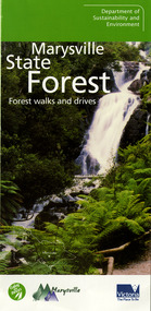
Ephemera (Item) - Information brochure, Department of Sustainability and Environment, Marysville State Forest, 2003
An information brochure on various forest walks and drives throughout the Marysville State Forest that was published by the Victorian Department of Sustainability and Environment in 2003.An information brochure on various forest walks and drives throughout the Marysville State Forest that was published by the Victorian Department of Sustainability and Environment in 2003.marysville, victoria, australia, information brochure, marysville state forest, lady talbot forest drive, taggerty river picnic area, the beeches, coupe loop, leadbeater's possum, beckter lookout, steavenson falls, marysville visitor information centre, department of sustainability & environmnet, lake mountain, cambarville, yarra ranges national park, cathedral range state park, murrindindi scenic reserve, gilberts gully loop, beauty spot nature trail, trestle track, michaeldene track, keppel lookout, marysville tour -
 Greensborough Historical Society
Book, Diamond Valley Sketchbook, 1973_
Diamond Valley Sketchbook, written by Brian McKinlay with drawings by Graham Hawley. Cover the area surrounding the Diamond Valley from Heidelberg to Mernda.A sketch book featuring landmarks around the Diamond Valley area in 1973. Many of these no longer exist.A 63 page hard back book with a map of the area covered by the book printed in blue in the inner covers. Three copies have a dust jacket printed in blue with title details, whilst the actual book cover lacks any detail. 4 copies.Some pencil markings in the inside cover.diamond valley, griffin house, rosehill, austin hospital, banyule house, trestle bridge eltham, shillinglaw cottage, montsalvat, old england hotel, eltham primary school, sweeney's cottage, pound bend tunnel, weller's pub, the eltham barrel, hassall's gallery, st katherine's chapel, yan yean reservoir, mernda hotel -
 Eltham District Historical Society Inc
Photograph, Liz Pidgeon, Heritage Excursion; The 1901 Eltham Railway Walk, 3 May 2014, 3 May 2014
Newsletter No. 216, May 2014 May Excursion – The 1901 Eltham Railway Walk The railway from Heidelberg to Eltham was opened in 1902. Over the previous year railway construction cut a curving swathe through Josiah Holloway’s 1851 Little Eltham subdivision. The survey plans for the railway show the owners and occupiers of land within Little Eltham affected by the railway alignment and for some distance each side. The plans show houses and other buildings but development at that time was rather sparse. Copies of these plans from the State Library of Victoria collection have been provided to the Society by Alan Sheehan. For our walk on 3rd May we intend to follow the railway from the Eltham Station to Ryans Road, which was the boundary of the adjoining Montmorency Farm. The return will be by way of nearby streets. Along the way we will discuss the details shown on the railway plans as well as more recent railway documents and photographs. At the conclusion and if time permits we can inspect the historical display at the Eltham Station. The walk is about 3 km in length and will take about 2.5 hours. It will start at 2 pm at the Eltham Railway Station car park (east/Main Road side) (Melway Ref. 21 J5).Born Digitalheritage excursion, activities, eltham district historical society, eltham railway station, eltham library, trestle bridge -
 Eltham District Historical Society Inc
Photograph, Liz Pidgeon, Heritage Excursion; The 1901 Eltham Railway Walk, 3 May 2014, 3 May 2014
Football match at Eltham Central Park between Eltham and Heidelberg Newsletter No. 216, May 2014 May Excursion – The 1901 Eltham Railway Walk The railway from Heidelberg to Eltham was opened in 1902. Over the previous year railway construction cut a curving swathe through Josiah Holloway’s 1851 Little Eltham subdivision. The survey plans for the railway show the owners and occupiers of land within Little Eltham affected by the railway alignment and for some distance each side. The plans show houses and other buildings but development at that time was rather sparse. Copies of these plans from the State Library of Victoria collection have been provided to the Society by Alan Sheehan. For our walk on 3rd May we intend to follow the railway from the Eltham Station to Ryans Road, which was the boundary of the adjoining Montmorency Farm. The return will be by way of nearby streets. Along the way we will discuss the details shown on the railway plans as well as more recent railway documents and photographs. At the conclusion and if time permits we can inspect the historical display at the Eltham Station. The walk is about 3 km in length and will take about 2.5 hours. It will start at 2 pm at the Eltham Railway Station car park (east/Main Road side) (Melway Ref. 21 J5).Born Digitalheritage excursion, activities, eltham district historical society, eltham railway station, eltham library, trestle bridge, eltham central park, football -
 Eltham District Historical Society Inc
Photograph, Liz Pidgeon, Heritage Excursion; The 1901 Eltham Railway Walk, 3 May 2014, 3 May 2014
Newsletter No. 216, May 2014 May Excursion – The 1901 Eltham Railway Walk The railway from Heidelberg to Eltham was opened in 1902. Over the previous year railway construction cut a curving swathe through Josiah Holloway’s 1851 Little Eltham subdivision. The survey plans for the railway show the owners and occupiers of land within Little Eltham affected by the railway alignment and for some distance each side. The plans show houses and other buildings but development at that time was rather sparse. Copies of these plans from the State Library of Victoria collection have been provided to the Society by Alan Sheehan. For our walk on 3rd May we intend to follow the railway from the Eltham Station to Ryans Road, which was the boundary of the adjoining Montmorency Farm. The return will be by way of nearby streets. Along the way we will discuss the details shown on the railway plans as well as more recent railway documents and photographs. At the conclusion and if time permits we can inspect the historical display at the Eltham Station. The walk is about 3 km in length and will take about 2.5 hours. It will start at 2 pm at the Eltham Railway Station car park (east/Main Road side) (Melway Ref. 21 J5).Born Digitalheritage excursion, activities, eltham district historical society, eltham railway station, eltham library, trestle bridge -
 Eltham District Historical Society Inc
Photograph, Liz Pidgeon, Heritage Excursion; The 1901 Eltham Railway Walk, 3 May 2014, 3 May 2014
Newsletter No. 216, May 2014 May Excursion – The 1901 Eltham Railway Walk The railway from Heidelberg to Eltham was opened in 1902. Over the previous year railway construction cut a curving swathe through Josiah Holloway’s 1851 Little Eltham subdivision. The survey plans for the railway show the owners and occupiers of land within Little Eltham affected by the railway alignment and for some distance each side. The plans show houses and other buildings but development at that time was rather sparse. Copies of these plans from the State Library of Victoria collection have been provided to the Society by Alan Sheehan. For our walk on 3rd May we intend to follow the railway from the Eltham Station to Ryans Road, which was the boundary of the adjoining Montmorency Farm. The return will be by way of nearby streets. Along the way we will discuss the details shown on the railway plans as well as more recent railway documents and photographs. At the conclusion and if time permits we can inspect the historical display at the Eltham Station. The walk is about 3 km in length and will take about 2.5 hours. It will start at 2 pm at the Eltham Railway Station car park (east/Main Road side) (Melway Ref. 21 J5).Born Digitalheritage excursion, activities, eltham district historical society, eltham railway station, eltham library, trestle bridge