Showing 481 items
matching victoria - settlement
-
 Lakes Entrance Historical Society
Book, Bird E C F, The Geomorphology of the Gippsland Lakes Region, 1978
A geomorphological study of the Gippsland lakes Region Victoria with reference to the effects of the artificial entrance, settlement, erosion and salinity on the changes to the configuration of the lakes, rivers, and coastline.natural history, waterways, genealogy -
Lakes Entrance Historical Society
Book, Tract Consultants Australia Pty Ltd, Storth Ryes Enviornment Effects Statement, 1988
Environment effects statement, Supplementary Report on the proposed Storth Ryes, Metung, Victoria, residential and resort development on the Gippsland Lakes. Includes concept plans and sketches.land settlement, commercial development -
Lakes Entrance Historical Society
Book, Calder Stuart and Winty, East Cunninghame and Lake Tyers Beach. A case study Report, 1976
A case history of resort development in the Lake Tyers Beach Victoria coast area, considering the history of land use and future planning with regard to environmental impact and social requirements.natural history, land settlement -
 The Beechworth Burke Museum
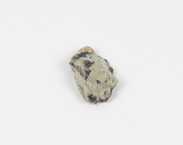
Geological specimen - Chalcopyrite
This specimen was recovered from Mica Schist, Canada. Chalcopyrite is a copper iron sulfide mineral with a chemical composition of CuFeS2. Its name derives from the Greek words for copper (chalco-) and brass (pyrite). It can be found in shades of yellow, green and grey, and, when exposed to acid, it can change to purple, blue, violet and yellow tones. Weathering can cause loss of its metallic luster and its brass-yellow colour. Chalcopyrite forms under various conditions, with the most significant deposits being hydrothermal in their origin. It is known globally as the most important ore of copper for thousands of years, and is thus considered a very important mineral formation. Given its golden appearance, it is often confused for the mineral gold, earning it the popular reputation as 'fool's gold' or 'yellow copper'. However, it can be straightforwardly distinguished from gold; the latter is soft, with higher specific gravity and a yellow streak, whereas chalcopyrite is brittle, easily scratched by a nail, and has a greenish grey streak. Copper was the first metal that was used by people. It was discovered by the Neolithic man about 9,000 years ago and it gradually replaced stone as it was easier to be shaped. In Australia, search for copper began after the European settlement, leading to the discovery of substantial deposits, like the one at the Olympic Dam in South Australia, which is regarded as one of the largest copper deposits in the world. Chalcopyrite has been used for copper since smelting processes began approximately five thousand years ago. Although by no means rare, this the specimen of this mineral can be used to reflect a wider history of industrial uses of copper for a significant portion of human history. This specimen is part of a larger collection of geological and mineral specimens collected from around Australia (and some parts of the world) and donated to the Burke Museum between 1868-1880. A large percentage of these specimens were collected in Victoria as part of the Geological Survey of Victoria that begun in 1852 (in response to the Gold Rush) to study and map the geology of Victoria. Collecting geological specimens was an important part of mapping and understanding the scientific makeup of the earth. Many of these specimens were sent to research and collecting organisations across Australia, including the Burke Museum, to educate and encourage further study.A solid hand-sized copper iron sulfide mineral of brass yellow, often with an iridescent tarnish, with greenish-black streak and submetallic luster. Chalcopyrite can be formed in several ways, including crystalizing from accessory minerals in igneous rocks, or from magma or within volcano sulfide deposits. Most commonly, chalcopyrite are found in hydrothermal conditions, where it forms in hydrothermal veins. As a member of the tetragonal crystal system, it often takes the shape of tetra-headed crystals, often with striations along the sides of the crystals. #18 Copper pyrites/(chalcopyrite) in/Laurentian Slate/(page 315 of inventory)/page missing from/descriptive catalogue/ Other label: 81 /fool's gold, chalcopyrite, mineral, rock, geology, geological, hydrothermal, neolithic, european settlement, olympic dam, south australia, stone, deposits, specific gravity, greenish grey streak, brittle, mineral gold, metallic luster, cufes2, greek words -
 Federation University Historical Collection
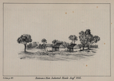
Print - Image, Batman's Huts, Indented Heads August 1835, 1835
Image from Westgarth's 'Port Phillip Settlement" (1883)Image of John Batman's huts at Indented Heads, Victoria. john batman, settlement, huts, architecture, melbourne, john wedge, indented heads, first contact -
 Lakes Entrance Historical Society
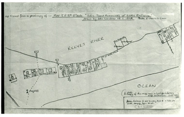
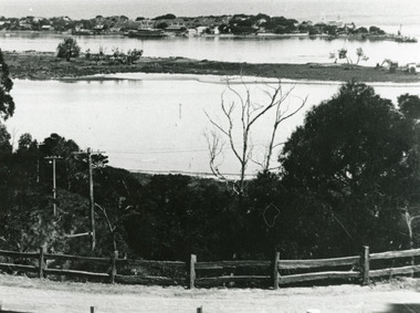
Photograph - New Works Plan, 1898
Map traced from a photocopy of :- Map TP8A Bairnsdale. 'Site. Sand Hummocks of Lakes Entrance'. Drawn by John Lardner 18 January 1898. Scale two chains to one inch. ( A photocopy of this map in Latrobe Library map collection, June 1983)Black and white photograph showing sketch map of 1898 by John Lardner Plan of Sites - sand hummocks. Drawing shows sites of buildings at entrance along Cunninghame Arm shoreline at Lakes Entrance, Victoria.land settlement, plan -
 Lakes Entrance Historical Society
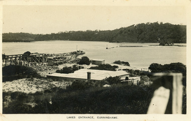
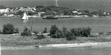
Postcard - New Works, Bulmer H D, 1910c
Also second copy same sizeBlack and white postcard showing view of Works buildings and north end of eastern pier. Cunninghame Arm and tip of Bullock Island and groyne work on right. Reeves channel and tip of Rigby Island on left. Mt Barkly and Kalimna Hills in background. Photo taken from top of dune. Roof of Carstairs boarding house centre foreground. Lakes Entrance VictoriaLakes Entrance, Cunninghamewaterways, settlement, historic buildings -
 Lakes Entrance Historical Society
Photograph - Carpentertown, Silver Reflections Studio, 1924c
Black and white photograph showing view of New Works. Village on dunes at entrance to Gippsland Lakes from ocean - Bass Strait. View shows SS Gippsland at New Works wharf, Cunninghame Arm, part of Bullock Island and mouth of North Arm, post and rail fence along roadway down Jemmys Point. Lakes Entrance Victoriawaterways, islands, settlement -
 Lakes Entrance Historical Society
Photograph - Carpentertown, 1920c
Copied from copy in J Whadcoat collectionBlack and white photograph showing P W D cottage on left and other Works buildings on dune at the entrance to Gippsland Lakes from the ocean - Bass Strait. View shows flagstaff on top of dune and flagstaff jetty in lake - Cunninghame Arm. Small sailing boat on left and other small craft on shoreline. Section of Bullock Island with vegetation, one telegraph pole and one dead tree on island. Shoreline of North arm in foreground. Lakes Entrance Victoriajetties, waterways, settlement, historic site, boats and boating -
 Lakes Entrance Historical Society
Photograph - Carpentertown, 1920c
Copied from a copy in possession of J WhadcoatBlack and white photograph showing view of seven cottages on dunes. View of several boats at jetties and on slipway, white shed on New Works wharf, Cunninghame Arm in front of cottages, part of Bullock Island showing some vegetation and one telegraph pole. Lakes Entrance Victoriawaterways, islands, settlement -
 Lakes Entrance Historical Society
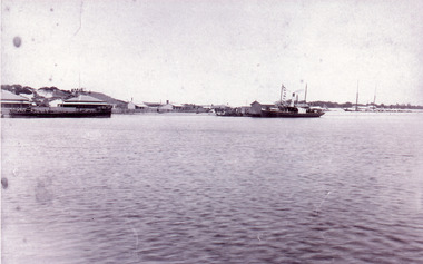
Photograph - New Works, 1890c
Three copies -Sepia photograph showing dunes, houses and Works buildings and boats at the entrance to Gippsland Lakes from ocean - Bass Strait. Photo shows two PWD houses on left and small school building, plus other Works buildings. Flagstaff on dune above houses. Large barge on left in front of houses. Large passenger steamer at New Works wharf with people waiting, has flags and bunting, two masted ketch on right of rock groynes. Lakes Entrance Victoriajetties, boats and boating, settlement, historic site -
 Lakes Entrance Historical Society
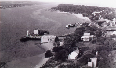
Photograph - New Works
Black and white photograph showing aerial view of Works buildings and cottages near man-made entrance to Gippsland Lakes Victoria boats and boating, topography, settlement, historic buildings -
 Warrnambool and District Historical Society Inc.
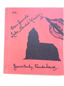
Book, Lake Condah Mission etc
... on the Lake Condah Aboriginal settlement, its inhabitants and its... Aboriginal Settlement History of Western Victoria Vanda Savill ...This is a book by Vanda Savill giving information on the Lake Condah Aboriginal settlement, its inhabitants and its immediate neighbouring settlers. Lake Condah Mission settlement in Western Victoria was established in 1867. Vanda Savill (1913-2005) with her husband ran a dairy farm and the Bower Birds Nest Museum and History Centre at Heywood. She was passionate about keeping alive the local people’s personal histories and for 20 years, in the 1970s, 80s and 90s, she wrote and published many books on the areas around Heywood. This book is of interest as it gives information on the history of Lake Condah Aboriginal Settlement and the neighbouring settlers in this area. It is also of interest because of the author’s warm and conversational writing style. This is a soft cover book of 164 pages. It has a red cover with black and white images on the front cover of a church and a hand holding a pen. It has been stapled. There are many black and white sketches, illustrations and photographs in the book. The text has been handwritten in cursive script and then printed. lake condah aboriginal settlement, history of western victoria, vanda savill, warrnambool, history -
 Lakes Entrance Historical Society
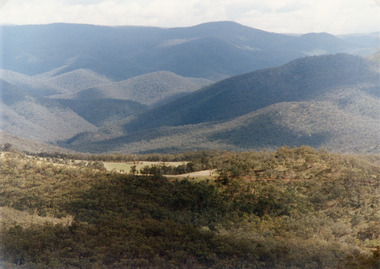
Photograph - Suggan Buggan, Tambo Shire, 1994 c
Also second identical copyColour photograph of the scenery in Suggan Buggan, showing very heavily forested mountainous country, a small area of cleared land centre left foreground. Suggan Buggan Victoriasettlement, agriculture, topography -
 Lakes Entrance Historical Society
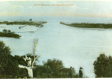
Postcard - The Entrance, 1900c
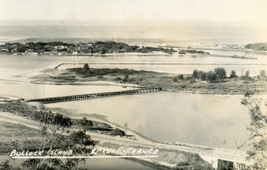
Also copy tinted postcard 10 x 15Coloured post card of the man made entrance through the sand dunes, taken from Jemmys Point. It shows the works and settlement at the entrance, Bullock Island and groynes to direct flow of lake waters towards entrance. Two men standing on Jemmys Point. Lakes Entrance VictoriaLakes Entrance, Cunninghame, Victoriaislands, waterways, topography -
 Lakes Entrance Historical Society
Postcard - Bullock Island, Bulmer H D, 1945
Black and white postcard of Bullock Island, Lakes Entrance, showing an extensive rock groyne to the south of the island, into which dredged sand and spoil is to be placed in order to extend the island's area. North Arm bridge, Bullock Island footbridge, New Works settlement and Entrance channel also in image. Lakes Entrance VictoriaBullock Island, Lakes Entranceboats and boating, fishing industry, islands -
 Bacchus Marsh & District Historical Society
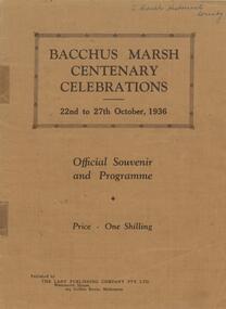
Book, Bacchus Marsh centenary celebrations, 22nd to 27th October, 1936: Official souvenir and programme, 1936
A souvenir booklet produced in Bacchus Marsh to commemorate 100 years since the arrival of European colonists in the district Bacchus Marsh in 1836. It contains a brief history of European settlement in the area and a description of some of the major industries and infrastructure of the region. Also included are several black and white images of significant local buildings, parks, geographic features and a group portrait of shire councilors; Published by The Lady Publishing Company, Melbourne, 1936. Edited by F. C. McC Crisp; Online edition accessible from State Library of Victoria at: https://find.slv.vic.gov.au/permalink/61SLV_INST/1sev8ar/alma99837471360763628 pages. 25cm. BMDHS Location: AR/SU4non-fictionA souvenir booklet produced in Bacchus Marsh to commemorate 100 years since the arrival of European colonists in the district Bacchus Marsh in 1836. It contains a brief history of European settlement in the area and a description of some of the major industries and infrastructure of the region. Also included are several black and white images of significant local buildings, parks, geographic features and a group portrait of shire councilors; Published by The Lady Publishing Company, Melbourne, 1936. Edited by F. C. McC Crisp; Online edition accessible from State Library of Victoria at: https://find.slv.vic.gov.au/permalink/61SLV_INST/1sev8ar/alma998374713607636bacchus marsh history, centenaries bacchus marsh -
 Hymettus Cottage & Garden Ballarat
Work on paper - Book, Drawing Room Scrap Book 1850
... was with the earlier settlement near Sorrento in Victoria. Melbourne Libraries ...fictionmelbourne, libraries, fawkner, book collector -
 Hymettus Cottage & Garden Ballarat
Work on paper - Book, Belgium in a Picturesque Tour
john pascoe fawkner, melbourne, belgium -
 Eltham District Historical Society Inc
Photograph - Digital Photograph, Alan King, St Margaret's Anglican Church, Pitt Street, Eltham, 30 January 2008
St Margaret’s Church of England was officially opened on December 12, 1861. It is the oldest intact church building in Eltham. At the time it was known as Christ Church until its consecration in 1871, when it was completely free of debt (£1,700 for the church and parsonage) despite the district’s poverty. This was largely due to the free labour and materials, including locally made bricks donated by local artisans and others. The church is historically significant because it is the oldest church in the former Shire of Eltham and has associations with the philanthropist and founder of Brighton, Henry Dendy (who donated the land on which the church is built), the architect Nathaniel Billing and the prominent local builder, George Stebbing. The church is architecturally and aesthetically significant because it is constructed in the Gothic Revival style with several stained-glass windows of various dates and is also a very early use of polychromatic brickwork in Victoria. Billing was one of the first Melbourne architects to employ polychromatic brickwork and an important early architect. The rear wall was intended to be temporary. A major feature of the design is the large buttresses with long, steeply graded upper faces. The overall design is well proportioned with the surface brick patterns relieving an otherwise austere design. The church is spiritually and socially significant because it has been an important place of worship for the people of Eltham for almost 150 years. The land on which the buildings stand was donated by Henry Dendy. Dendy arrived in Melbourne in 1841 after purchasing in England eight square miles at Brighton under the system of "special surveys". After this land passed out of his hands, Dendy moved about Victoria, visited England, then returned to settle in Eltham where he purchased a flour mill. Dendy chaired the meeting held in 1860 “for the purpose of devising such means as may be expedient for the establishment of a Church of England in the township of Eltham”. He became chairman and treasurer of the church committee. Unlike the establishment of many early churches in Victoria where a vicar was appointed to a parish and later a permanent church was constructed, the population at Eltham initiated action to build a church. The nearest church at that time was at Heidelberg and the Eltham settlement was part of the parish of St Johns Heidelberg. Isolation and the tedious, time consuming journey between Heidelberg and Eltham resulted in the Eltham community taking its own action. The original vicarage (Dendy House) at the rear of the church is also an important part of the cultural significance of this place because it is connected to the church and the development of the Eltham area. Together, the church and the vicarage are aesthetically significant because they form a significant streetscape feature. The mud-brick community hall designed by Robert Marshall was added in 1978. In 2014 the original temporary rear wall was removed as part of a modern extension designed by Architects Atelier Wagner and constructed by Conrad Construction and Management. Covered under Heritage Overlay, Nillumbik Planning Scheme. National Trust of Australia (Victoria) State significance Victorian Heritage Published: Nillumbik Now and Then / Marguerite Marshall 2008; photographs Alan King with Marguerite Marshall.; p67 St Margaret’s Anglican Church in Pitt Street, Eltham, which officially opened on December 12, 1861, is the oldest intact church building in Eltham.1 With the nearby courthouse and police station, it was one of the first permanent community buildings in the district. The church and vicarage are on the Register of the Heritage Council of Victoria and the National Trust of Australia – Victoria. The church is important as an early example of polychrome brickwork by the notable architect Nathaniel Billings. It is also notable for its historic associations with the early settlement of the Shire of Eltham and its connection with Henry Dendy, Brighton’s founder.2 Henry Dendy, who lived in Eltham much longer than at Brighton, chaired the original meeting which planned the church, and he donated the half-acre (0.2ha) site. Dendy had arrived in Melbourne in 1841 after buying eight square miles (20.7sq km) at Brighton while in England. After this land passed out of his hands, he eventually settled in Eltham where he bought a flour mill, west from the corner of Main Road and Pitt Street (then called Brewery Lane). The vicarage was named Dendy House after him. The Eltham settlers were unusual in initiating the establishment of a church. Usually in Victoria a vicar was appointed to a parish and then a permanent church was constructed. But then, the nearest church was at Heidelberg, which was a tedious and time-consuming journey. St Margaret’s builder was a local, George Stebbing, who also constructed the former Methodist, later Uniting, Church at John Street and the Shillinglaw Cottage near Eltham’s Central Park. It is believed the first Anglican Bishop of Melbourne, Bishop Perry, dedicated the church. After the ceremony he joined in the festivities at the nearby pub and a bill was sent to the parish for teas taken there by the bishop with other participants. The first vicar was the Reverend Robert Mackie from 1864 to1866. St Margaret’s Church was originally called Christ Church until its consecration in 1871, when it was completely free of debt (£1700 pounds for the church and parsonage) despite the district’s poverty. This was largely due to the free labour and materials, including local bricks, donated by local artisans and others. St Margaret’s Church is in the Gothic Revival tradition with a buttressed nave, paired lancet windows, porch and bell-cote. It was the first polychromatic brick church in Australia, using softly contrasting coloured brickwork.3 Billing was one of the first architects to introduce polychrome brickwork into Melbourne. His original drawings for St Margaret’s survive in a folio of his architectural work. However the church’s brickwork is more subdued than in his drawings. About half the windows – those in clear glass with gold borders – are original. The stained glass windows were made much later, but the one behind the altar is thought to be the oldest in the Diamond Valley. It was to be temporary until the congregation could afford to extend the church. In the early 1960s the original cedar pews were replaced by blonde timber pews and the originals were sold to restaurants and to private individuals. Eminent local sculptor Matcham Skipper created a crucifix for the church. A major addition was made in 1978, when the weatherboard hall was replaced by a mud-brick hall. Made of local material, it was designed by local architect and a former shire president Robert Marshall. The mud-brick hall reflects the style of building in Eltham of the late 1970s and for which Eltham is well-known. Perhaps because its earthy tones blend with the surrounding environment, the hall sits well with the church building. St Margaret’s membership has included economist and ABC chairman, Richard Downing; political commentator, diplomat and academic, William Macmahon Ball; Eltham civic leader, Charles Wingrove; artist, Peter Glass; and Eltham’s first postmaster, Frederick Falkiner.This collection of almost 130 photos about places and people within the Shire of Nillumbik, an urban and rural municipality in Melbourne's north, contributes to an understanding of the history of the Shire. Published in 2008 immediately prior to the Black Saturday bushfires of February 7, 2009, it documents sites that were impacted, and in some cases destroyed by the fires. It includes photographs taken especially for the publication, creating a unique time capsule representing the Shire in the early 21st century. It remains the most recent comprehenesive publication devoted to the Shire's history connecting local residents to the past. nillumbik now and then (marshall-king) collection, eltham, st margaret's anglican church, st margaret's church, st margarets church hall, christ church -
 Sunbury Family History and Heritage Society Inc.
Photograph, Sunbury & District Heritage Association Inc, Vineyards Exhibition, August 1996
The vineyards exhibition was mounted by the Sunbury & District Heritage Association in the former George Evans Museum from August 1996 to January 1997. It featured the establishment of the vineyards and the wine industry in Sunbury from the 1860s to the present day. From the early days of European settlement in Sunbury, it was found that the soils and climate suited the growing of grapes, especially the east facing slopes along Vineyard Road. A number of people of German origin established vineyards along there. By the end of the nineteenth century and limited spending power as a result of the 1890s depression, the demand for wine declined in Victoria with beer being the preferred beverage.While Phylloxera destroyed the vines in many areas of Victoria, Sunbury's grapevines were not affected. As the demand for wine increased in the 1960s - 70s, some vineyards in the Sunbury area were replanted.The vineyards established in Sunbury in the 1860s were one of the earliest agricultural pursuits taken up by European settlers in the area and remained an important industry for 40 years.A non-digital coloured photograph of a display board advertising an exhibition of vineyards in the Sunbury area.vineyards, sunbury, vignerons, wine production -
 Victorian Railway History Library
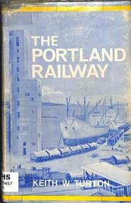
Book, Turton, Keith, The Portland Railway, 1968
... and the growing inland settlements of Western Victoria and Southeast South ...A history of the rail network based on Portland that was developed from the 1870s to transport goods between its port and the growing inland settlements of Western Victoria and Southeast South Australiaill, maps, p.179.non-fictionA history of the rail network based on Portland that was developed from the 1870s to transport goods between its port and the growing inland settlements of Western Victoria and Southeast South Australiarailroad construction - victoria - history, railroads -- victoria -- history -
 Glenelg Shire Council Cultural Collection
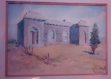
Work on paper - Watercolour, Florence Tatham Mellblom, Portland Shire Hall, n.d
From Antiques Reporter: Florence Tatham Mellblom, (Australian, 1900 - 1983), Visit Portland The First Victorian Settlement, during the Centenary Celebrations from 15th to 23rd November 1934', 1934 colour lithograph, signed 'F. Mellblom' in image lower left, 63.5 x 101.5 cm. Linen-backed. Text continues in lower margin: 'Arbuckle, Waddell Pty Ltd Print, Melb.', Mellblom (nee Henry) was a painter, naturalist and photographer. She was born at Portland, Victoria, and studied art in Ballarat. She was a talented etcher from childhood, and joined the Portland Camera club. She also produced many watercolour paintings of the historic places of Portland. She was married (1932) to Karl Enoch Mellblom.A bluestone building on an arid landscape. Yellow grass in the foreground with one tree standing at the front. There is a blue sky behind. The left hand wing has a door which is slightly open. Above each wing is an engraved piece of stone. Left - Portland, right - Shire. An old rickety fence to the left of the building.Bottom Right - F. Mellblomfemale artist, women, female, landscape, portland landscape, portland shire -
 Emerald Museum & Nobelius Heritage Park
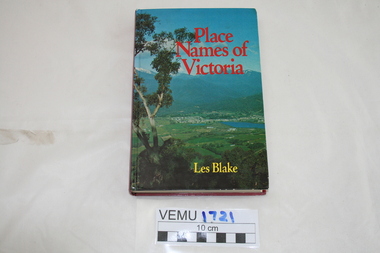
Book, Place Names of Victoria, 1977
The sequence of naming was a chronological representative of land discovery and settlement. Starting from the native population to the explorers, the squatters and settlers and surveyors during the gold rush. The term 'places' refers to physical features of the coast and land as well as districts, towns and cities.Hard Cover book written by Les Blake and first published in 1977. The jacket has a photograph of Mount Beauty and the Kiewa Valley from the Tawonga Gap.place names of victoria -
 Lakes Entrance Historical Society
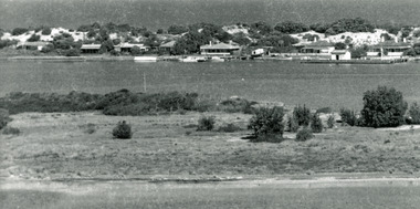
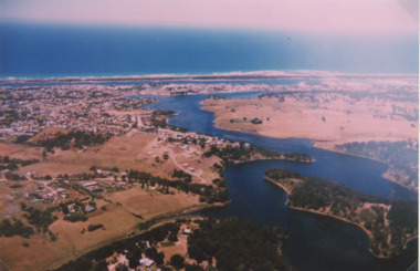
Photograph - North Arm Lakes Entrance, 1993c
Also second aerial photograph showing Blairs Road track to Wyanga Winery glimpse of Tarra Landing number 03857.1 size 10 x 15 cmAerial photograph of North Arm Frenchmans Gully and Wyanga Winery lower left Tarra Landing estate centre North Arm and Cunninghame Arm Lakes Entrance Victoriaaerial photograph, houses, settlement, township -
Lakes Entrance Historical Society
Book, Land Conservation Council, Victoria, East Gippsland Area Review Final Recommendations Land Conservation, 1986
Report describing the physical nature of the East Gippsland area (Victoria) study area. History, climate, geomorphology, land use, flora and fauna are presented. Map included.topography, land settlement -
Lakes Entrance Historical Society
Book, Colwell, Max, The Big Rivers' Murray, Darling, Murrumbidgee, 1978
The Murray-Darling basin river system - called the rivers of life. Victoria, New South Wales and South Australia. 32,000 Kms. along the system.waterways, catchments, natural disasters, bridges, commerce, land settlement -
Lakes Entrance Historical Society
Book, Regional Coordination Group and Strategy Steering Committee, The East Gippsland Planning and Development Strategy, 1997
An outline of planning and proposed development by the East Gippsland, Victoria, Shire Council from 1997 to the year 2010. Maps included.township, land settlement, tourism -
Lakes Entrance Historical Society
Book, Higgins, Julie, Yes, We Remember, 1976
Recollections of St. George's Church, Nowa Nowa, Victoria at 14th. March, 1976. Included are references to the settlers and development of Lake Tyers, Wairewa and Tostaree.land settlement, religion, township -
Lakes Entrance Historical Society
Book, Blakeman, Elizabeth Harley, Judith, Houses of Nowa Nowa in the year 2000, 2000
A description of all houses still standing at Nowa Nowa,Victoria in 2000 and the families living in them.township, buildings, settlement