Showing 1338 items
matching walking
-
 Greensborough Historical Society
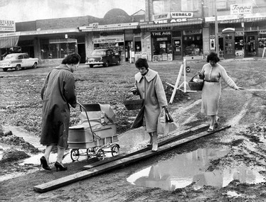
Photograph - Digital Image, Macleod c1961, 1961c
Digital photograph women carefully walking along a muddy Aberdeen Street in Macleod, c1961.Digital image of black and white photograph.macleod, aberdeen street macleod -
 Eltham District Historical Society Inc
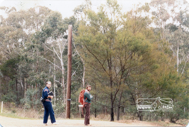
Photograph, Long Gully and environs, Watsons Creek catchment, c.Oct 1982, 1982
Looking for a route for a walking trail from Kinglake to the Yarra River. Not shown is Rod Roscholler. Colour photograph1982, long gully, watsons creek, lodi francesconi, russell yeoman -
 Stawell Historical Society Inc
Book - History and Field Guide, A History and Field Guide to the Grampians ( Gariwerd), 2021
Aboriginal History, European History, walking Trails, Wild Flowers, waterfalls, Bird Life.Soft Cover: Colour Photo on the front: Waterfall. on the rear RockartThis copy is signed by the author: Best Wishes David M Welch. See context -
 Bendigo Historical Society Inc.
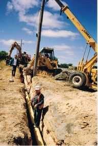
Photograph - CASTLEMAINE GAS COMPANY COLLECTION: PHOTO EXCAVATION
Several workers, one standing on the pipe in the trench another one walking near the trench, three men in the trench, one man walking along the trench, 2 on excavators, pipe laying in pre dug trench, left background is trencher, middle background is trencher being used to lower pipe into trench, Crane to right being used to steady the light postKodakorganisation, industry, gas and fuel -
 Marysville & District Historical Society
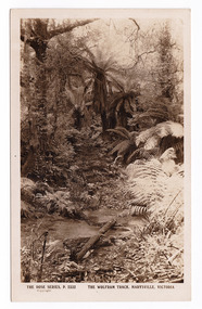
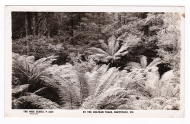
Postcard (item) - Black and white postcard, Rose Stereograph Company, The Wolfram Track, Marysville, Victoria, 1913-1967
A postcard in a series produced by the Rose Stereograph Company in Victoria, Australia as a souvenir of Marysville.A black and white photograph of the Wolfram Track which is part of the Wilks Creek Walking Track near Marysville in Victoria. The Wolfram Track is named after the Wilks Creek Wolfram Mine which opened in around 1894. Wolframite is one of the principle ores of tungsten. The discovery was made in Wolfram Creek by a Mr Robinson who was probably a local of the district. Four creeks eventually proved to carry alluvial deposits of the ore; Wolfram Creek, Opas Creek, Quartz Creek and Main Creek. These creeks run south-east into Deep Creek, a tributary of the O'Shannassy River which, in turn, runs into the Yarra River.POST CARD The "Rose" Series/ De Luxe A Real Photograph/ Produced in Australia Published by the Rose Stereograph Co.,/ Sydney and Melbourne.wolfram track, wilks creek walking track, marysville, victoria, p. 2332, walking track, rose series postcard, postcard, souvenir, wolframite, wolfram creek, opas creek, quartz creek, main creek, deep creek, o'shannassy river, yarra river, mining -
 Bendigo Military Museum
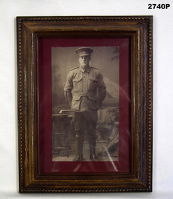
Photograph - PHOTOGRAPH WW1, FRAMED, c. WW1
Timber coloured plastic frame & backing. Black & white photo of soldier in uniform holding a walking stick behind him. Photo has maroon border.Printed on back: "TOP" On label: "SGT JOHN JOSEPH MILBURN Reg No 3188 Enlisted 1915 - RTA 1919 15th Machine Gun Company 5th Machine Gun Battalion WWI"photography-photographs, frame accessories, passchendaele barracks trust -
 Phillip Island and District Historical Society Inc.
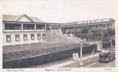
Photograph, Early 20th Century
One of a collection of 7 photographs donated by Steve Stefan, Archivist, St Frances Church, MelbourneBlack & White copy of a postcard showing Bayview Guest House, Cowes. People on the Verandah and man in the garden. Two women walking along the footpath in front."Photo Shop Series" "Bayview Guest House" "Cowes"bayview guesthouse cowes, guesthouses cowes phillip island, steve stefan -
 Phillip Island and District Historical Society Inc.
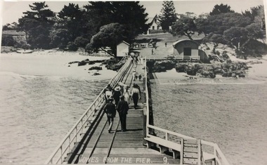
Photograph, Cowes from the Pier
Part of a collection of 'Rose & Valentine' series of Post Cards. Copied by John Jansson 1984Black & White Postcard. View of Cowes from Pier. People walking on pier & buggies on "Car" park - showing the rails for unloading goods from shipping,.Cowes from the pier - 9local history, photography, photographs, postcards, phillip island, black & white postcard copy, cowes pier, cowes, jetties, isle of wight hotel -
 Mission to Seafarers Victoria
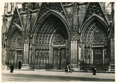
Photograph - Photograph, Black and white, Allan Charles Quinn, Main entrance to the Cathedral - Rouen, 5 June 1949
This photograph is one of a series taken by Allan Quinn while travelling through France in mid-1946. There are several letters relating to this journey.This is a photograph from the Allan Charles Quinn collection which is a collection of letters and photograph depicting aspects of life at sea for a young man in the era immediately following World War II.A black and white photograph of the Cathedral in Rouen, taken on the 5th of June, 1949. It shows three large arched doors, and a few people walking on the street in front of it.On reverse: ROUEN 5-6-49 handwritten in blue ink. Below this is the mark "ItI" in pencil.allan quinn, photograph, rouen, france, normandy, ww2, wwii, world war two, 1939-1945, cathedral, door -
Glenelg Shire Council Cultural Collection
Photograph - Photograph - Henty Beach, Portland, n.d
Black and white photo, lawns at Henty Beach. Numerous people in period costume sitting, lying and walking on the lawns. Railway pier and Ocean Pier in backgroundBack: 'Band Reserve & Beach Portland' - handwritten, black ink '20' - pencilhenty beach, coast, beach, recreation, leisure, ocean pier, portland harbour -
 Orbost & District Historical Society
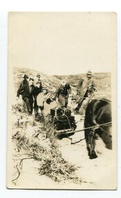
black and white photograph, first half 20th century
Access to the cottages at the lighthouse was difficult and the horse-drawn sled was in use until the 1940s. It was used to haul personal goods as wel as those needing medical attention at far-off Orbost. This photograph could be connected with the Gledhills in the 1930s when a medical emergency necessitated a removal to Orbost. Dr Nettleton was the doctor at Orbost at that time. (there could be a link through donor) Point Hicks is claimed to be Captain James Cook’s first sighting of mainland Australia. The lighthouse was built on the point during 1887 and 1888 and commenced operation in 1890, built from concrete and with timber keepers quarters. It was connected to mains electricity in 1965, and then to solar power recently. Originally access to Point Hicks was by sea. In 1920 a return trip, by land to Cann River, 47 kilometres away from the light station, took two days. By 1946 the journey had been reduced to 36 hours by a combination of horse and jeep. During the early 1950s it was still a 12-hour ordeal. The light no longer works, it was turned off 21 years ago and the Point Hicks lighthouse is now powered by a much smaller, more modern light. the lightkeepers' cottages are used for tourist accommodation.This photograph is associated with Point Hicks, a historically important lightstation in East Gippsland.A small black / white photograph of a horse dragging a sled with suitcases on it. There are seven people walking behind, one holding the reins. They are waalking through a sand dune.on label on back - "Bring Out to Light House keeper from Point Hicks"point-hicks-lighthouse -
 Bendigo Historical Society Inc.
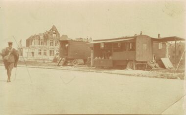
Postcard - ACC LOCK COLLECTION: SEPIA PHOTO OF CARAVANS AND BUILDING, POSTCARD, 1914-1918
Postcard, WW1, Sepia photo of two stationery wooden caravans with a damaged building to the left. Soldier at left walking away from camera. Location not known.postcard, ww1, france -
 National Vietnam Veterans Museum (NVVM)
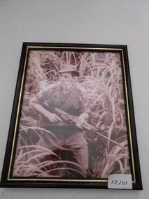
Photograph, Jungle Patrol
Framed photgraph of a Corporal in jungle greens walking through long grass. CPL is armed with an SLR and has two bandoliers of ammo around his neckCPL Chevronsphotograph, jungle patrol, slr -
 El Dorado Museum Association Inc.
Photograph (item) - Digital Image
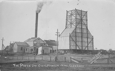
Cocks Pioneer Mine El Dorado, Power Station No. 2 was established in 1914 and located near junction of Reid's and Clear Creeks, Byawatha. Cocks Pioneer Electric Gold & Tin Mine Company was formed in 1899. The company's first power station, located at the eastern end of the valley began operating with its 340 Kilowatt steam-powered generator. By 1909, from 2,500,000 cubic yards worked, reported recovery was 17,284 ounces of gold and 224 tons of tin ore. By 1909, Cocks Pioneer’s power plant had become inadequate and uneconomical. The barge was floated downstream about a mile, but lost time caused the operations to cease. Following testing, a new mine was established by diverting Reid's Creek at a cost of £25,000. Settling dams were built, one of which held 1,935,900 cubic feet. Sold earth banks, built against a wall of stringy bark saplings constructed and laced with vertical props, were built. In 1914, the company was reformed as Cock’s Pioneer Gold and Tin Mines NL, another power station was constructed at the western end of the township, near the junction of Clear and Reid's Creeks. From 6,800,000 cubic yards of material processed, the returns were 64,397 ounces of gold and 855 ton of tin. Cocks Pioneer mine then moved the barge downs stream and continued sluicing. In 1929 Cocks Pioneer Electric Gold and Tin Mining Company ceased operations due to a drop in values. Cock’s Pioneer Gold and Tin Mines NL carried on large-scale hydraulic sluicing operations until 1941. Handwritten on front: 'THE POWER STN COCKS, PIONEER MINE, ELDORADO' / 'THELMA STUDIO / [underlined] WANGARATTA'mining, gold, tin, cocks pioneer, power, sluicing, el dorado, eldorado, byawatha, thelma studios, wangaratta, gold mining, tin mining, reid's creek, clear creek -
 Rutherglen Historical Society
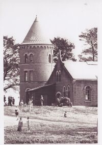
Image, Olive Codling
One of the buildings of the Mount Ophir winery. Photo was taken by Miss Olive Codling, who was a life member of the Wodonga Historical Society. Photograph is believed to have been taken on the occasion of a Tour by the North East Branch, 1st combined meeting.Black and white photograph of a brick building with a tower. A number of people are walking about by the buildings. This photograph is one of two printed on a single sheet of photographic paper.mt ophir, mount ophir, wine industry -
 Rutherglen Historical Society
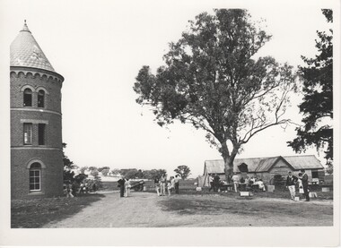
Image, Olive Codling
Some of the buildings of the Mount Ophir winery. Photo was taken by Miss Olive Codling, who was a life member of the Wodonga Historical Society. Photograph is believed to have been taken on the occasion of a Tour by the North East Branch, 1st combined meeting.Black and white photograph of several buildings. On the left is a brick tower building. To the right, in the background, is a timber shed. A number of people are walking about or are seated at tables.mt ophir, mount ophir, wine industry -
 Tatura Irrigation & Wartime Camps Museum
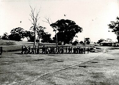
Photograph, Japanese Officers
Group of Japanese POW officer's being transferred to POW Camp 13 in August 1944 after the suicidal breakout from Cowra POW Camp.Black and white photograph stuck on coreflu backing depicting a group of men walking through a camp. Guard on the left, trees in background and hug to the back right.camp 13, murchison camp, cowra camp, japanese internees, cowra breakout. -
 Bendigo Historical Society Inc.
Article - Vahland Buildings Tour Information
Collection of notes and images, relating to Vahland Buildings in the Bendigo CBD for a Walking Tour. . Collection is in plastic pockets, contained in a clear fronted plastic pocket binder. vahland, bendigo cbd, buildings, architect -
 Bendigo Historical Society Inc.
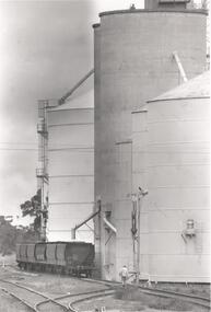
Photograph - PHOTOGRAPH. ELMORE SILOS, 1993
Photograph. Elmore silos next to railway line. Six railway trucks positioned ready to be filled. Man walking between lines toward silos and trucks.elmore, silos, agricultural -
 The Beechworth Burke Museum
Photograph
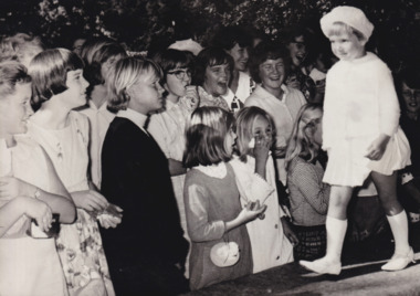
The photograph depicts a young child walking across a platform in front of a crowd of children and young adults.The photograph provides insight into entertainment, performance and recreation in Beechworth during the 1950s. The item's interpretive capacity is enhanced by its strong relationship to other photographs in the catalogue. Collectively, these records enrich the community's understanding of how the arts have developed in Beechworth since the mid-twentieth century.Black and white rectangular photograph printed on matte photographic paper.Reverse: 5663 / Faye Somat /entertainment album, entertainment, parade, theatre, theatrical group, arts, recreation, beechworth -
 Warrnambool and District Historical Society Inc.
Artefact, Shillelagh, Early 20th century
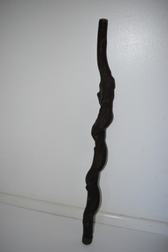
This walking stick or club is of a heavy quality and could be classified as an Irish shillelagh, although it lacks the heavy curved knob at the top that characterizes the shillelagh. It does not seem typical of the walking sticks used in Australia in the late 19th and early 20th centuries although it appears to date from those times. It may have come from an overseas country.This walking stick has no known local provenance but it is an interesting item and is kept as a curio from the past.This is a piece of black wood (blackthorn?) shaped from a gnarled and knotted piece of wood to make a rough, curved shape. The shaft is rounded at the top and tapering to a smaller round shape at the bottom. The top has a brass-coloured metal band.walking sticks, household items, warrnambool -
 Halls Gap & Grampians Historical Society
Photograph - B/W, C 1927
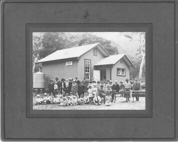
This is a photo of the opening of the new Halls Gap School in 1927. The man on the chair with a walking stick is Dr. Fox.The photo shows a group of ten men, fifteen women, twenty two children (including one toddler) and one toddler in arms, posing outside a wooden building with a water tank on the left side. The four adults on the right are sitting/leaning on two benches. A sign on the side of the building reads "Halls Gap School 3058". There are large trees and a mountain range in the background.education, halls gap -
 Whitehorse Historical Society Inc.
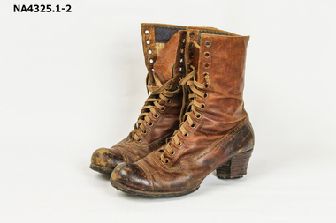
Footwear - Walking Boots, C. 1900 - 1920
Boots belonged to donor's grandmother, who was born in 1888. She used to go bush walking in the 1920sBrown boots - laced up - leather - heavily repaired on sole. Scuffed on heels. Fancy stitching around perimeter of boots and over the toes. Long tongue with laces to tie on books. There are 13 eyelets.3 426.36costume, female footwear -
Whitehorse Historical Society Inc.
Map, Yarran Dheran Reserve, n.d
Yarran Dheran Walking Trailnon-fictionYarran Dheran Walking Trailyarran dheran, schwerkolt cottage, walking trails -
 Marysville & District Historical Society
Postcard (item) - Black and white postcard, Rose Stereograph Company, By the Wolfram Track, Marysville, Vic, 1913-1967
A postcard in a series produced by the Rose Stereograph Company in Victoria, Australia as a souvenir of Marysville.A black and white photograph of a part of the forest that the Wolfram Track, which is part of the Wilks Creek Walking Track, runs through. The Wilks Creek Walking Track is in Marysville in Victoria. The Wolfram Track is named after the Wilks Creek Wolfram Mine which opened in around 1894. Wolframite is one of the principle ores of tungsten. The discovery was made in Wolfram Creek by a Mr Robinson who was probably a local of the district. Four creeks eventually proved to carry alluvial deposits of the ore; Wolfram Creek, Opas Creek, Quartz Creek and Main Creek. These creeks run south-east into Deep Creek, a tributary of the O'Shannassy River which, in turn, runs into the Yarra River.POST CARD The "Rose" Series/ De Luxe A Real Photograph/ Produced in Australia Published by the Rose Stereograph Co.,/ Armadale, Victoria.wolfram track, wilks creek walking track, walking track, marysville, victoria, p. 2334, rose series postcard, postcard, souvenir, p. 2332, wolframite, wolfram creek, opas creek, quartz creek, main creek, deep creek, o'shannassy river, yarra river, mining -
 Bendigo Military Museum
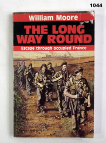
Book, The Long Way Round. Escape Through Occupied France, 1988
Black and red soft cover. Drawing on front cover of seven soldiers walking along a path with bombed township in the background. Author - WILLIAM MOORE Pages 182Written on front page "Donated by Bgo Y Mens Clubbooks-military-history, escape -
 Bendigo Military Museum
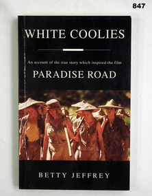
Book, Angus & Robertson, White Coolies, c.1997
An account of the true story which inspired the film Paradise Road. Black, soft cover book with photo of a group of women walking & carrying tools, 104 pages.On first page written in pen: Wilma Aram Young 27.7.97 Donated by Bgo Y Mens Clubbooks, military, history, imprisonment -
Glenelg Shire Council Cultural Collection
Postcard - Postcard - Lighthouse and harbour Portland Victoria, n.d
Postcard, Lighthouse & Harbour, Portland, Victoria, from the "Rose" series ----colourview No 503, showing adult & three children walking on an unsealed road north of Whaler's Bluff. -
 Kiewa Valley Historical Society
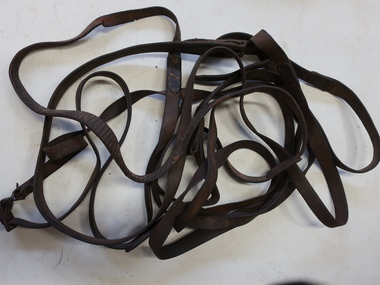
Horse Reins, Horse Equipment
Reins are the means by which a horse rider or driver communicates directional commands to the horse's head. Pulling on the reins can be used to steer or stop the horse.Used by residents of the Kiewa Valley especially farmers.Made of leather with steel buckles. The reins are connected to the bit in the mouth and go to the rider or the person walking / controlling the horse/horses eg. on a dray, wagon, plough etc.horse reins, horse equipment -
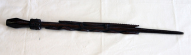 Orbost & District Historical Society
carved stick
A hand - carved walking stick with a diamond shape at the top. It has a snake down one side and a crocodile down the other. There are four carved faces around the top.walking-stick carving ethnographic