Showing 1122 items
matching waterway
-
 Lakes Entrance Historical Society
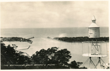
Photograph - The Entrance, 1950c
Black and white photograph of the entrance, taken from lookout on Jemmys Pointwaterways, dredging, ocean -
 Lakes Entrance Historical Society
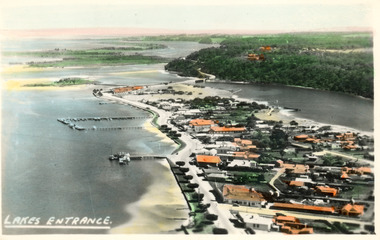
Photograph - Lakes Entrance, 1945c
Two tinted copies, one 8.5 x 13.5 and one 6.5 x 9Black and white postcard showing town, twelve memorial cypress trees and spotting tower on foreshore, post office wharf, boat harbour, Club Hotel at west end of esplanade with five palm trees opposite, causeway to Bullock Island, highway bridge over North Arm, highway up to Jemmys Point, Rigby, Fraser and Flannagan Island's towards Metung. Lakes Entrance VictoriaLakes Entrance islands, aerial photograph, waterways, township -
 Lakes Entrance Historical Society
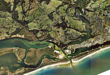
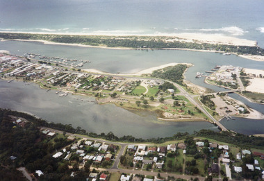
Photograph - Topography, 2007c
Colour aerial photograph of the land forms around the entrance to the Gippsland Lakes, from Kalimna West to Lakes Entrance, North Arm to the ocean. Shows massive sand buildup between Rigby Island and Kalimna, also Bullock Island. Lakes Entrance Victoriawaterways, navigation, topography -
 Lakes Entrance Historical Society
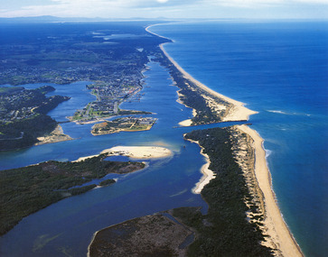
Photograph - Lakes Entrance, 1985c
Photo was cut from Tourist brochureColour photograph showing aerial view of township and the Ninety Mile Beach. Pecks factory on Bullock Island, Old North Arm bridge, bitumen for carpark for future. Fishermen's Club near North Arm Bridge. Photo shows East end of Rigby Island and Snake Island. Glimpse of Red Bluff, Lake Bunga and Lake Tyers in far east. Lakes Entrance Victoriabridges, coast, waterways, topography, township -
 Lakes Entrance Historical Society
Photograph - Lakes Entrance, 1997c
Colour print of aerial view looking south of western side of township. Shows housing on Kalimna Hill, North Arm, part of Bullock Island, Cunninghame Arm, the outer barrier and east pier of man made entrance. Lakes Entrance Victoriawaterways, township -
 Lakes Entrance Historical Society
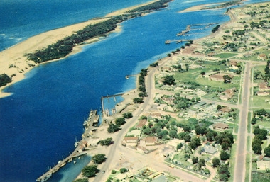
Photograph - Lakes Entrance, 1960c
Copied from postcardColour photograph aerial view of the township, shows also Cunninghame Arm, the hummocks and distant view of Bullock Island and the entrance. Lakes Entrance Victoria hotels, township, waterways -
 Lakes Entrance Historical Society
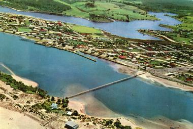
Photograph - Lakes Entrance, 1975c
Copied from postcardColour photograph aerial view of the township, also showing North Arm, Cunninghame Arm, footbridge, and kiosk and Lifesaving Club on hummocks. Lakes Entrance Victoriawaterways, township, islands, jetties, aerial photograph -
 Lakes Entrance Historical Society
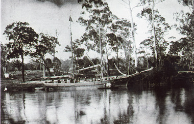
Photograph - Ethel BT, 1900c
Captain ..Limschow, crew member A J legg and two others were rescuedBlack and white photograph showing schooner Ethel BT in Tambo River near Bennetts Brook. Sheds and buildings and post and rail fences on farm in background. Swan Reach Victoria boats and boating, waterways -
 Lakes Entrance Historical Society
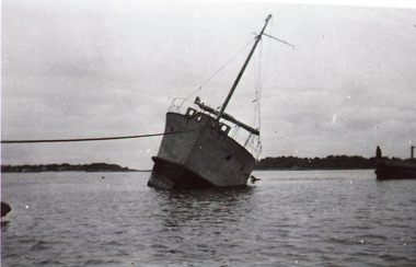
Photograph, 1920c
Black and white photograph showing unidentified vessel in channel. Vessel leaning to one side, rope securing it off to the left. Entrance to ocean obscured behind the vessel that appears to have run aground. Lakes Entrance Victoriaships and shipping, shipwrecks, waterways, ocean, fishing industry -
 Lakes Entrance Historical Society
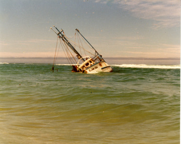
Photograph - St John Star, 1981
Date made 13 August 1981Colour photograph of the fishing boat St John Star aground between breakers and shoreline, 20 km east of Lakes Tyers, near Lakes Entrance, Victoria.fishing industry, ships and shipping, waterways, shipwrecks -
 Lakes Entrance Historical Society
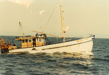
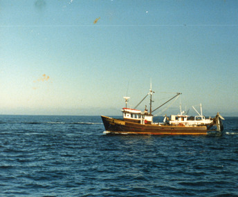
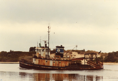
Photograph - Subron DVE, 1980c
Owner 'Labro'?? converted it then left the areaColour photograph of scallop boat Subron TVE at sea off. Two men working the dredge table. Lakes Entrance Victoriafishing industry, ships and shipping, waterways -
 Lakes Entrance Historical Society
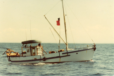
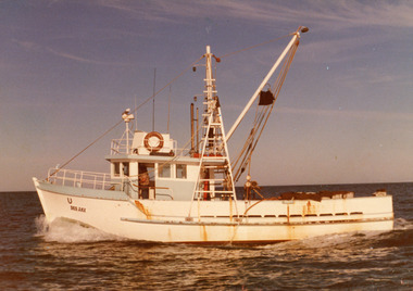
Photograph - Kaingah, 1975c
Built by Bulls of Metung for Harry Rose 1956c for shark fishingColour photograph of scallop fishing boat Kiangah in Bass Strait off Lakes Entrance, Victoriafishing industry, ships and shipping, waterways -
 Lakes Entrance Historical Society
Photograph - Dee Jay, 1980c
'Dee Jay' built for ? Franks, later owned by Roy Carstairs, then to Win Hobson, Port AlbertColour photograph of fishing boat Dee Jay at sea off Lakes Entrance, Victoriafishing industry, ships and shipping, waterways -
 Lakes Entrance Historical Society
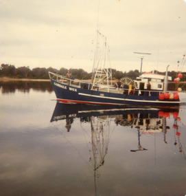
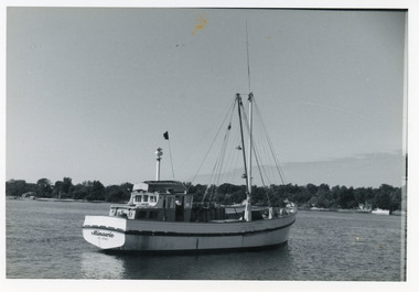
Photograph - Candale, 1980c
Camdale thought to have gone to QLD 1980'sColour photograph of fishing boat Camdale reg no W6Y in Cunninghame Arm, Lakes Entrance, Victoriafishing industry, ships and shipping, waterways -
 Lakes Entrance Historical Society
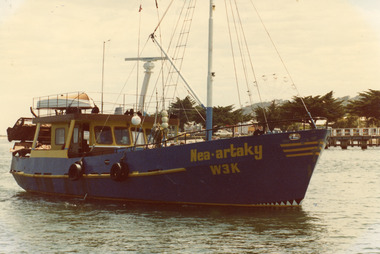
Photograph - Nea.artaky, 1980c
A 'Bay' boat owner Michael Walker?Colour photograph of scallop fishing boat Nea.artaky in Cunninghame Arm, Carnival Ferris wheel in background and memorial cypress trees along Esplanade. Lakes Entrance Victoriafishing industry, ships and shipping, waterways -
 Lakes Entrance Historical Society
Photograph - Sand Groper, 1980c
Owner Keith Bonds from NungurnerColour photograph of the scallop fishing boat Sand Groper working the scallop beds in Bass Strait. Boat in background working in opposite direction. Lakes Entrance Victoriafishing industry, ships and shipping, waterways -
 Lakes Entrance Historical Society
Photograph - Bug Tug, 1980c
Former tug boat, owner Scott Horton, now at StanleyColour photograph of a scallop fishing boat known locally as the Bug Tug in Cunninghame Arm. Hill Sixty on hummocks in background. Lakes Entrance Victoriafishing industry, ships and shipping, waterways -
 Lakes Entrance Historical Society
Photograph - Minawie, Holding George, 1978c
Black and white photograph of the fishing boat Minawie in Cunninghame Arm, cottages opposite in background. Lakes Entrance Victoriafishing industry, ships and shipping, waterways -
 Lakes Entrance Historical Society
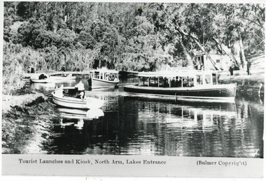
Photograph - Comer's tearoom, Bulmers Studio, 1940
Also black and white copy 10 x 15Black and white photograph showing MV Blackbird, a similar launch at back, plus three smaller boats on left, off Comers Tearooms landing at top of North Arm. Thick vegetation on bank. Lakes Entrance VictoriaTourist Launches and Kiosk, North Arm, Lakes Entrance (Bulmer Copyright)waterways, boats and boating, tourism, tearoom -
 Lakes Entrance Historical Society
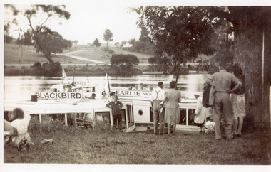
Photograph - MV Earlie, 1950 c
Also one black and white enlarged copy 13 x 21 cmBlack and white photograph showing tourist launch Blackbird and MV Earlie moored in Tambo River. Shows tourists about to board vessels. Two smaller boats tied to opposite bank, buildings above the road. Large old tree on right of people. Boat skipper in white coat and cap. Swan Reach Victoriawaterways, boats and boating, tourism -
 Lakes Entrance Historical Society
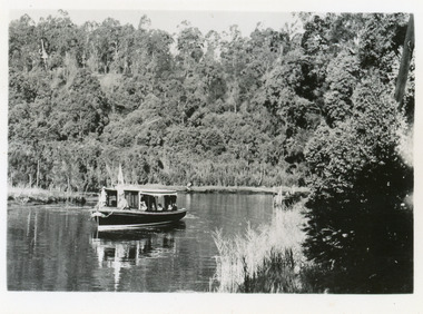
Postcard - MV Blackbird, Bulmers Studio, 1940
Black and white small format postcard showing Peels Tourist Ferry MV Blackbird leaving Comer's North Arm Jetty. Steep wooded banks, reeds along the shore. Lakes Entrance VictoriaNorth Arm Launch Trip, Lakes Entrance (on reverse)waterways, restaurant, boats and boating, tourism -
 Lakes Entrance Historical Society
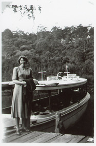
Photograph - Loch Ard, Willis, Ron, 1951
Black and white photograph showing MV Lochard at jetty at top of North Arm. Well timbered bank opposite, lady on jetty. Lakes Entrance VictoriaBarbara Willis, 1951. Loch Ard trip to North Arm (on reverse)jetties, waterways, boats and boating, tourism, people -
 Lakes Entrance Historical Society
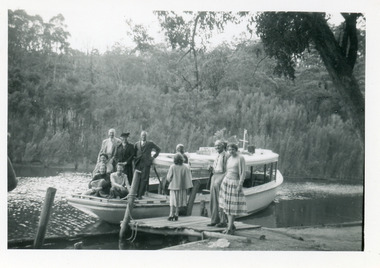
Photograph - Loch Ard, 1956
Note on back says - Snowy Mountain Tour, M V Loch Ard, North Arm, Lakes Entrance, Tuesday April 17 1956, where we had morning teaBlack and white photograph showing MV Loch Ard in North Arm at tearooms jetty, shows several people on the boat and others on the landing. Thick vegetation on opposite bank. Lakes Entrance Victoria waterways, boats and boating, tourism, people, tearoom -
 Lakes Entrance Historical Society
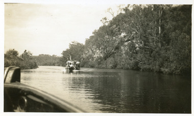
Photograph - Tambo River, 1950 c
Road between Swan Reach and Tambo Upper follows river bank opposite cliffsBlack and white photograph print showing tourist launch, possibly 'MV Blackbird' on Tambo River below the cliffs, taken from another boat. Tambo Upper Victoria waterways, boats and boating, tourism -
 Lakes Entrance Historical Society
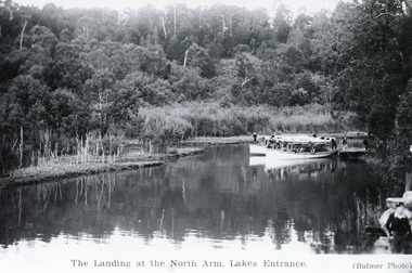
Postcard - Comer's Landing, 1945 c
Second copy existsBlack and white postcard showing two white tourist ferries, Peel's, at Comer's Jetty at top of North Arm. Several people on boats and on jetty. Boy on bank at bottom right hand corner of photo. High wooded banks, some dead vegetation on shoreline. Lakes Entrance VictoriaThe Landing at the North Arm Lakes Entrance (Bulmer photo)vegetation, waterways, boats and boating, tourism -
 Lakes Entrance Historical Society
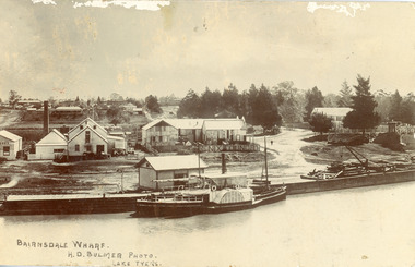
Postcard - P.S. Tanjil, Bulmer H D, 1910 c
Postcard was addressed to Mr. H Lindamen, C/o JCD, Bairnsdale. Postcard bears a One Penny red Queen Victoria stamp, franked with number 17. Message on card scribbled out, another stamp has been removed. Also enlargement 16 x 25 cmBlack and white postcard showing P S Tanjil at Bairnsdale Wharf, Victoria. Shed and timber and hand crane on wharf. Industrial buildings, eg, butter factory, foundry behind wharf, post and rail fences, gravel roads and tannery on right, pine trees and end of bridge on far right. Bairnsdale township in background.Bairnsdale Wharf. H.D Bulmer Photo Lake Tyersships and shipping, waterways, wharfs -
 Lakes Entrance Historical Society
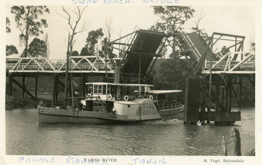
Postcard - P.S. Tanjil, Vogt, Stanley, 1920 c
Two copies existBlack and white postcard showing P S Tanjil passing downstream under Swan Reach Bridge on Tambo River, East Gippsland, Victoria.Paddle Steamer Tanjil Tambo River Swan Reach Bridge. S. Vogt Bairnsdaleships and shipping, waterways, bridges -
 Lakes Entrance Historical Society
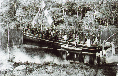
Photograph - S.S. Tambo, 1885 c
Black and white photograph showing S S Tambo, trail trip 1882 on Tambo River shows large crowd on boat, bunting flying from mast, two small row boats either side. Thick bush on far bank. Post and rail fence going into the water lower right hand corner. Camp oven or boiler and camp fire lower left hand corner. Tambo Upper Victoriaboats and boating, tourism, waterways -
 Lakes Entrance Historical Society
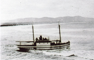
Photograph - S.S. Stormbird, 1905 c
Photo was taken before ship was lengthened by ten feet at Peter Tierney's slip at Paynesville, near Bairnsdale, VictoriaBlack and white photograph showing S S Stormbird crossing bar shows Stormbird in front, coast and Howe Range in background. Mallacoota, Victoria.ships and shipping, waterways, fishing industry -
 Lakes Entrance Historical Society
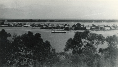
Photograph - Lakes Entrance, 1945 c
The Hulk of the Baang Yarnda on the North Arm foreshore. (Note in album)Black and white photograph showing view from Kalimna cliff overlooking North Arm and township, Cunninghame Arm and sand dunes out to Bass Strait. Hulk of old Baang Yarnda moored in North Arm, towed there in 1939 and left to rot. Thick vegetation in foreground. Lakes Entrance Victoria.township, waterways