Showing 576 items matching "yarra yarra district"
-
 Emerald Museum & Nobelius Heritage Park
Yarra Valley Mountain and District Football League Results1994, Fixtures and Ladders, Emerald Player Profiles, circa 1994
... Yarra Valley Mountain and District Football League...yarra valley mountain district football league... Emerald yarra-valley-and-the-dandenong-ranges The reports ...The reports are primarily historically and socially significant for understanding the local football community especially as it names many members of the team. Also gives some insight into the local families who were regularly involved with the Emerald Football Club.black plastic 4 ring binderlabeled "Emerald Senior Football Club Results & Ladders - 1994 Previews & Write Ups - 1994 Player Profiles - 1994:emerald, football, match reports, fixtures, ladders, seniors, yarra valley mountain district football league -
 Emerald Museum & Nobelius Heritage Park
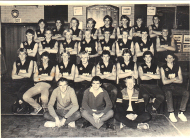
B/W Photograph, 1986 YVMDFL Cup Squad, 1986
... B/W photograph of the 1986 Yarra Valley & Mountain.... yarra valley mountain districts football league football nab ...The Cup Squad was an under-18 team selected to play for the NAB AFL Under-18 Championship (formerly known as the "Teal Cup"). The players and officials in this photograph are residents of Emerald and environs.B/W photograph of the 1986 Yarra Valley & Mountain Districts Football League Cup Squad, 27 people in all. Woori Yallock Cricket Club shield on wall in background.Handwritten on rear: YVMDFL Cup Squad - 1986 ["TEAL" crossed out, replaced by "YVMDFL"] Richard Wicks - Emerald Robbie Walker - Emerald Shane Brockwell - Emerald Geoff Ladner - Healsville [sic} then/later Emerald yarra valley mountain districts football league, football, nab under-18 championship -
 Eltham District Historical Society Inc
Negative - Photograph, Warrandyte Bridge over River Yarra, c.1910
... District Historical Society and Yarra Plenty Regional Library ...View of the 1875 timber trestle bridge over the Yarra River reproduced from a newsprint image. Also known as Anderson's Creek (Road) Bridge A contract was accepted for William Elliot to erect a bridge over the Yarra River at Warrandyte on Anderson's Creek Road and other improvements for £1,331.6.2 - Gazette No. 143. Tuesday, November 13th 1860 - http://gazette.slv.vic.gov.au/view.cgi?year=1860&class=general&page_num=2161&state=V&classNum=G143&id=). The bridge was washed away by floods in 1863. It was replaced with a taller timber trestle structure in October 1875, designed and built by C.S. Wingrove, Shire Clerk, Engineer and Surveyor for Eltham Shire Council. A replacement for this bridge was commenced in 1955 to cope with increasing traffic and this structure was widened in 2018 to meet further traffic demands. Argus (Melbourne, Vic. : 1848 - 1957), Thursday 23 September 1875, page 7 ________________________________________ THE WARRANDYTE BRIDGE. The ceremony of formally opening the newly erected bridge over the Yarra at Ander-son's Creek was performed on Monday last, in the presence of the members of the Eltham and Bulleen shire councils whose territories it joins, and a goodly number of the residents of the district. The task was delegated to Mr. Cameron, M.L.A., who, after a few introductory remarks declared the bridge to be opened, and christened it the " Warrandyte Bridge." The party then adjourned to Grant's Hotel, where a cold collation had been prepared. The chair was taken by the president of the Eltham shire (Mr. John Bell) and the vice chair by Mr. Kent, a member of the Bulleen council. Mr Robert Williamson proposed "Success to the bridge," coupling with it the name of Mr. Cameron, to whose exertions was in the main to be attributed the erection of that structure which was an ornament to the district and would prove of great service to both sides of the river. Mr. Cameron, in responding, alluded to the great difficulties, mainly of a pecuniary nature, that had been encountered in carrying out the project, and which had only been got over by their united efforts and by the liberal spirit in which the late Commissioner of Roads had dealt with the case. The healths of the contractor and the engineer were also drunk. The bridge is a trussed timber one, resting on yellow box piles sunk into the solid rock, each pier being weighted with 50 tons of stone. The abutments consist of dry stone walls, 6ft. thick at the base, and tapering to 3ft. on the top, the face of the work having a batter of 1 to 1. The length of the bridge is 308ft., there being four openings in the centre of 66ft. each, and two at the ends of 20ft. each. The width in the clear is 9½ft., and the height from the bed of the river about 33ft. The approaches comprise 1,100 cubic yards of earthwork, and the formation of 48 chains of sideling, the whole cost of the work, which was carried out under the direction of the engineer to the Eltham Shire Council, being £1,413.This photo forms part of a collection of photographs gathered by the Shire of Eltham for their centenary project book,"Pioneers and Painters: 100 years of the Shire of Eltham" by Alan Marshall (1971). The collection of over 500 images is held in partnership between Eltham District Historical Society and Yarra Plenty Regional Library (Eltham Library) and is now formally known as the 'The Shire of Eltham Pioneers Photograph Collection.' It is significant in being the first community sourced collection representing the places and people of the Shire's first one hundred years.Digital image 4 x 5 inch B&W Neg B&W Print 12.5 x 9 cmsepp, shire of eltham pioneers photograph collection, warrandyte, bridge -
 Eltham District Historical Society Inc
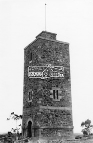
Photograph, Shire of Eltham War Memorial Tower. Eltham-Yarra Glen Road, Kangaroo Ground, unveiled 11 November 1926, c.1926
... in partnership between Eltham District Historical Society and Yarra ...This photo forms part of a collection of photographs gathered by the Shire of Eltham for their centenary project book,"Pioneers and Painters: 100 years of the Shire of Eltham" by Alan Marshall (1971). The collection of over 500 images is held in partnership between Eltham District Historical Society and Yarra Plenty Regional Library (Eltham Library) and is now formally known as the 'The Shire of Eltham Pioneers Photograph Collection.' It is significant in being the first community sourced collection representing the places and people of the Shire's first one hundred years.Digital imagesepp, shire of eltham pioneers photograph collection, kangaroo ground, war memorial tower -
 Eltham District Historical Society Inc
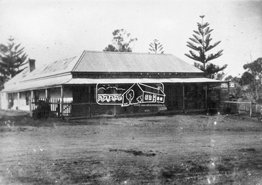
Photograph, C. Wraight's Kangaroo Ground Supply Store, c.1910
... District Historical Society and Yarra Plenty Regional Library ...Cornelius (Con) and his wife Elizabeth ran the store and post office from about 1904. Their son Donald became involved with the store in the 1930s. A petrol bowser was added in early 1933 and a second in 1937. The Wraights ran the store till the 1940s. Elizabeth died 10 April 1952 and Cornelisu May 30, 1954.This photo forms part of a collection of photographs gathered by the Shire of Eltham for their centenary project book,"Pioneers and Painters: 100 years of the Shire of Eltham" by Alan Marshall (1971). The collection of over 500 images is held in partnership between Eltham District Historical Society and Yarra Plenty Regional Library (Eltham Library) and is now formally known as the 'The Shire of Eltham Pioneers Photograph Collection.' It is significant in being the first community sourced collection representing the places and people of the Shire's first one hundred years.Digital image (negative of original print missing)shire of eltham pioneers photograph collection, kangaroo ground, cornelius wraight, eltham-yarra glen road, general store, kangaroo ground store -
 Eltham District Historical Society Inc
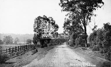
Photograph, Tom Prior, Nearing Eltham, from Research, Vic., c.1905, c.1905
... District Historical Society and Yarra Plenty Regional Library ...View looking south along the main road from Research to Eltham Part of a presentation, "Roads and Byways of the Shire of Eltham", by Russell Yeoman to the 12 September 1990 Society meeting. Slides shown inclyuded copies of old photos and recent images ranging from the suburban streets of Eltham and Montmorency to the mountain roads of Kinglake. In the byways category are views of some iof the Shire's bicycle paths including then recently completed sections of the Main Yarra Trail at Lower Plenty.This photo forms part of a collection of photographs gathered by the Shire of Eltham for their centenary project book,"Pioneers and Painters: 100 years of the Shire of Eltham" by Alan Marshall (1971). The collection of over 500 images is held in partnership between Eltham District Historical Society and Yarra Plenty Regional Library (Eltham Library) and is now formally known as the 'The Shire of Eltham Pioneers Photograph Collection.' It is significant in being the first community sourced collection representing the places and people of the Shire's first one hundred years. The Reynolds family were early settlers in Research. The Reynolds/ Prior collection of photographs were taken by Tom Prior, the maternal uncle of Ivy Reynolds, around 1900 and the 60 photos in the album give a fine overview of many of the landmarks of Research and Eltham over 100 years ago. lvy lived in the family home for many years at 106 Thompson Cres Research. Ivy's father, Ernst Richard Reynolds and grandfather, Richard Reynolds, lived at the same address. Ivy's father Richard worked for Mr. Trail on his property in Research. Reynolds Road is named after the family. Mr Tom Prior (wife Eva) worked at the Melbourne zoo. He was very innovative and made his own camera, using the black cloth hood to exclude the light. The photographs are a reminder of the rural nature of Research and Eltham and its rich heritage.Digital image (Neg missing)shire of eltham pioneers photograph collection, eltham, main road, research (vic.), reynolds prior collection -
 Eltham District Historical Society Inc
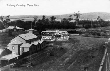
Photograph, Railway Crossing - Yarra Glen
... Eltham District Historical Society Inc 728 Main Rd Eltham ...Source: Royal Historical SocietyThis photo forms part of a collection of photographs gathered by the Shire of Eltham for their centenary project book,"Pioneers and Painters: 100 years of the Shire of Eltham" by Alan Marshall (1971). The collection of over 500 images is held in partnership between Eltham District Historical Society and Yarra Plenty Regional Library (Eltham Library) and is now formally known as the 'The Shire of Eltham Pioneers Photograph Collection.' It is significant in being the first community sourced collection representing the places and people of the Shire's first one hundred years.Digital imagesepp, shire of eltham pioneers photograph collection, yarra glen, railway crossing -
 Eltham District Historical Society Inc
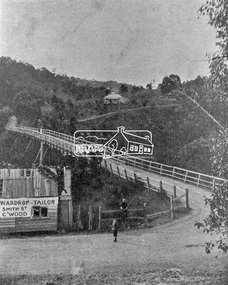
Photograph, Warrandyte Bridge on River Yarra
... Eltham District Historical Society Inc 728 Main Rd Eltham ...Bridge across the Yarra River which links North Warrandyte and Warrandyte. A house sits prominantly on a hill in the distance. A wooden building on the side of the road before the bridge has advertising for Wardrop Tailor, Smith Street, Collingwood. It is suggested that the photo has had this fake information added at a later date. Wardrop Tailor did operate from about 1915 to 1921. Alternataive title: Warrandyte Bridge - River Yarra. "Wardrop-Tailor, Smith St. C'wood" sign - faked?This photo forms part of a collection of photographs gathered by the Shire of Eltham for their centenary project book,"Pioneers and Painters: 100 years of the Shire of Eltham" by Alan Marshall (1971). The collection of over 500 images is held in partnership between Eltham District Historical Society and Yarra Plenty Regional Library (Eltham Library) and is now formally known as 'The Shire of Eltham Pioneers Photograph Collection.' It is significant in being the first community sourced collection representing the places and people of the Shire's first one hundred years.Digital imagesepp, shire of eltham pioneers photograph collection, warrandyte, bridge, north warrandyte, yarra river, wardrop tailor, collingwood -
 Eltham District Historical Society Inc
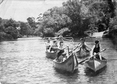
Negative - Photograph, Canoeing on the Yarra River at Warrandyte, Nov. 1934
... in partnership between Eltham District Historical Society and Yarra ...This photo forms part of a collection of photographs gathered by the Shire of Eltham for their centenary project book,"Pioneers and Painters: 100 years of the Shire of Eltham" by Alan Marshall (1971). The collection of over 500 images is held in partnership between Eltham District Historical Society and Yarra Plenty Regional Library (Eltham Library) and is now formally known as the 'The Shire of Eltham Pioneers Photograph Collection.' It is significant in being the first community sourced collection representing the places and people of the Shire's first one hundred years.Digital image 4 x 5 inch B&W Negshire of eltham pioneers photograph collection, warrandyte, canoeing -
 Eltham District Historical Society Inc
Photograph, Eltham - Floods in 1934
... District Historical Society and Yarra Plenty Regional Library ...To the left of picture is the Main Road Bridge over the Diamond Creek in Eltham South when the Diamond Creek was in flood. The Yarra also was in flood. In early December 1934 the "Greatest flood in the history of the Yarra" occured, according to The Argus newspaper. Bridges and houses were swept away with hundreds of people left homeless across the state. The historic 1934 flood of the Diamond Creek and Yarra River set the criteria for future planning with respect to flood water rise.This photo forms part of a collection of photographs gathered by the Shire of Eltham for their centenary project book, "Pioneers and Painters: 100 years of the Shire of Eltham" by Alan Marshall (1971). The collection of over 500 images is held in partnership between Eltham District Historical Society and Yarra Plenty Regional Library (Eltham Library) and is now formally known as 'The Shire of Eltham Pioneers Photograph Collection.' It is significant in being the first community sourced collection representing the places and people of the Shire's first one hundred years.Digital image 4 x 5 inch B&W Negsepp, shire of eltham pioneers photograph collection, eltham, diamond creek (river), 1934 flood, diamond creek, floods, main road bridge -
 Eltham District Historical Society Inc
Photograph, Floodwaters, Diamond Creek, Eltham, 1934
... District Historical Society and Yarra Plenty Regional Library ...The Diamond Creek in flood near the Main Road bridge at Eltham, Victoria. The Yarra also was in flood. In early December 1934 the "Greatest flood in the history of the Yarra" occured, according to The Argus newspaper. Bridges and houses were swept away with hundreds of people left homeless across the state. The historic 1934 flood of the Diamond Creek and Yarra River set the criteria for future planning with respect to flood water rise.This photo forms part of a collection of photographs gathered by the Shire of Eltham for their centenary project book, "Pioneers and Painters: 100 years of the Shire of Eltham" by Alan Marshall (1971). The collection of over 500 images is held in partnership between Eltham District Historical Society and Yarra Plenty Regional Library (Eltham Library) and is now formally known as 'The Shire of Eltham Pioneers Photograph Collection.' It is significant in being the first community sourced collection representing the places and people of the Shire's first one hundred years.Digital image 4 x 5 inch B&W Neg (2 frames on one neg) 9 x 15.5 cm B&W printflooding, eltham, shire of eltham pioneers photograph collection, sepp, diamond creek (river), floods, 1934 flood, diamond creek -
 Eltham District Historical Society Inc
Photograph, Odyssey House Victoria, 28 Bonds Road, Lower Plenty, 6 March 1990
Odyssey House drug rehabilitation centre in Bonds Road, Lower Plenty is a distinctive landmark, especially when viewed from across the Yarra at Templestowe. It was built in the 1950’s as a seminary for the Blessed Sacrament Fathers. Because of the poor and circuitous road access, a suspension footbridge was built across the river. As well as providing easy access for the priests residents of Templestowe could attend services at the seminary. The bridge is now part of the Yarra Trails system.Colour photographlower plenty, bonds road, odyssey house -
 Eltham District Historical Society Inc
Photograph, Henley Bridge, Spring Excursion, Exploring the Upper Yarra, 22 October 1995, 22/10/1995
... with Bridges. Situated on the Yarra River, 5.5 kms south of Christmas...: Christmas Hills Past and Present, Yarra Glen & District Historical ...[article by Bettina Woodburn in EDHS Newsletter No. 105, November 1995:] EXPLORING THE UPPER YARRA - We enjoyed the Spring Excursion, this year "Exploring the Upper Yarra" - in spite of the constant rain and the countryside under the cloud cover, especially in the valleys, being mainly shiny shades of green. The occasional fields of buttercups, clumps of arum lilies and splendid rhododendron and other flowering bushes became very special. The Cobb and Co coach was warm and a cosy retreat as we zig-zagged on the highways and byways to glimpse the Yarra River, upstream and down, its secret places, and particularly the many bridges. Russell excelled as 'Poet Laureate', reading from Dacre Smyth's book. This 1979 publication includes paintings of all the bridges along the river with poems and brief descriptions of each one. Some of the bridges are in out-of-the-way places and are not very well known. We looked forward to hearing the poetry as much as seeing the 'constructions'… Big Pat (was he short or tall, lean or fat? - he did win the £200 reward for discovering gold and had the creek named after him), about the 'Eddies'?, and the disliked 'meccano' bridge in Warburton, etc. etc. The hot roast lunch in the old Reefton Hotel was also most welcome. It was easy to imagine it peopled by miners and early settlers. Starting by crossing the new (1974) concrete bridge at Warrandyte we headed through Wonga Park with views to the Christmas Hills and to the escarpment of the Yering Gorge, which causes flood waters to back up through the Yarra Glen plain, so avoiding disasters downstream. At the end of a long driveway we found the wooden, privately owned Henley Bridge (1935 after the 1934 floods). This facilitates access to different parts of Henley Farm and to Lilydale. Everard Park, named after Blanche Shallard's father, a State Member for 17 years, below the Highway Yarra crossing was in need of care. It is 10 miles from Yarra Glen by road but, as "Yarra Marra” canoeists well know, 32 winding miles down by water. After more delightful countryside scenes we joined the Warburton Highway at Woori Yallock. From the old Railway Station at Launching Place the Centennial Trail for walkers, cyclists and horse riders has replaced the rails. The line from Lilydale was opened in 1901, and the last diesel freight train ran to Warburton in 1965. It continued to rain as we had morning tea in Warburton in a shelter between footbridges. From here we continued upstream past the Bridge to O'Shannassy Lodge and Reservoir, Starvation Creek, and the Peninsular tunnel (miners dug it as at Pound Bend) which we visited (scrambling down those steps!) on our return after lunch. Our furthermost point was the Upper Yarra Dam Reserve (and vast catchment area). Finished in 1957 after ten years' work and 100 years after Yan Yean, it supplies much of Melbourne's water. After crossing the 30m Launching Place Bridge to the Eltham side of the Yarra and Healesville, we saw in the distance the Yarra Glen Timber Trestle Bridge over the river flats "the longest for years in the land it was said!" Harry's dream of "better weather over the Divide" unfortunately didn't come true, but I'm sure we 36 members will retain happy memories of a day that was wet and green and filled with Bridges. Situated on the Yarra River, 5.5 kms south of Christmas Hills on private property. This timber trestle bridge is said to have been built some time after 1907 by Melbourne master-builder, David Mitchell (the father of Dame Nellie Melba), to connect his two "Henley Farm" properties with Lilydale. In earlier days, when the McPhersons owned the property, their children used a punt to cross the river to attend Yering Primary School. This private bridge is best viewed from the end of Wendy Way. - Source: Christmas Hills Past and Present, Yarra Glen & District Historical Society, 2004.Two colour photographsactivities, henley bridge, upper yarra -
 Eltham District Historical Society Inc
Photograph, Spring Excursion, Exploring the Upper Yarra, 22 October 1995, 22/10/1995
[article by Bettina Woodburn in EDHS Newsletter No. 105, November 1995:] EXPLORING THE UPPER YARRA - We enjoyed the Spring Excursion, this year "Exploring the Upper Yarra" - in spite of the constant rain and the countryside under the cloud cover, especially in the valleys, being mainly shiny shades of green. The occasional fields of buttercups, clumps of arum lilies and splendid rhododendron and other flowering bushes became very special. The Cobb and Co coach was warm and a cosy retreat as we zig-zagged on the highways and byways to glimpse the Yarra River, upstream and down, its secret places, and particularly the many bridges. Russell excelled as 'Poet Laureate', reading from Dacre Smyth's book. This 1979 publication includes paintings of all the bridges along the river with poems and brief descriptions of each one. Some of the bridges are in out-of-the-way places and are not very well known. We looked forward to hearing the poetry as much as seeing the 'constructions'… Big Pat (was he short or tall, lean or fat? - he did win the £200 reward for discovering gold and had the creek named after him), about the 'Eddies'?, and the disliked 'meccano' bridge in Warburton, etc. etc. The hot roast lunch in the old Reefton Hotel was also most welcome. It was easy to imagine it peopled by miners and early settlers. Starting by crossing the new (1974) concrete bridge at Warrandyte we headed through Wonga Park with views to the Christmas Hills and to the escarpment of the Yering Gorge, which causes flood waters to back up through the Yarra Glen plain, so avoiding disasters downstream. At the end of a long driveway we found the wooden, privately owned Henley Bridge (1935 after the 1934 floods). This facilitates access to different parts of Henley Farm and to Lilydale. Everard Park, named after Blanche Shallard's father, a State Member for 17 years, below the Highway Yarra crossing was in need of care. It is 10 miles from Yarra Glen by road but, as "Yarra Marra” canoeists well know, 32 winding miles down by water. After more delightful countryside scenes we joined the Warburton Highway at Woori Yallock. From the old Railway Station at Launching Place the Centennial Trail for walkers, cyclists and horse riders has replaced the rails. The line from Lilydale was opened in 1901, and the last diesel freight train ran to Warburton in 1965. It continued to rain as we had morning tea in Warburton in a shelter between footbridges. From here we continued upstream past the Bridge to O'Shannassy Lodge and Reservoir, Starvation Creek, and the Peninsular tunnel (miners dug it as at Pound Bend) which we visited (scrambling down those steps!) on our return after lunch. Our furthermost point was the Upper Yarra Dam Reserve (and vast catchment area). Finished in 1957 after ten years' work and 100 years after Yan Yean, it supplies much of Melbourne's water. After crossing the 30m Launching Place Bridge to the Eltham side of the Yarra and Healesville, we saw in the distance the Yarra Glen Timber Trestle Bridge over the river flats "the longest for years in the land it was said!" Harry's dream of "better weather over the Divide" unfortunately didn't come true, but I'm sure we 36 members will retain happy memories of a day that was wet and green and filled with Bridges.Two colour photographsactivities, upper yarra, upper yarra dam -
 Eltham District Historical Society Inc
Photograph, Yarra River from Henley Bridge, Kangaroo Ground, Spring Excursion, Exploring the Upper Yarra, 22 October 1995, 22/10/1995
[article by Bettina Woodburn in EDHS Newsletter No. 105, November 1995:] EXPLORING THE UPPER YARRA - We enjoyed the Spring Excursion, this year "Exploring the Upper Yarra" - in spite of the constant rain and the countryside under the cloud cover, especially in the valleys, being mainly shiny shades of green. The occasional fields of buttercups, clumps of arum lilies and splendid rhododendron and other flowering bushes became very special. The Cobb and Co coach was warm and a cosy retreat as we zig-zagged on the highways and byways to glimpse the Yarra River, upstream and down, its secret places, and particularly the many bridges. Russell excelled as 'Poet Laureate', reading from Dacre Smyth's book. This 1979 publication includes paintings of all the bridges along the river with poems and brief descriptions of each one. Some of the bridges are in out-of-the-way places and are not very well known. We looked forward to hearing the poetry as much as seeing the 'constructions'… Big Pat (was he short or tall, lean or fat? - he did win the £200 reward for discovering gold and had the creek named after him), about the 'Eddies'?, and the disliked 'meccano' bridge in Warburton, etc. etc. The hot roast lunch in the old Reefton Hotel was also most welcome. It was easy to imagine it peopled by miners and early settlers. Starting by crossing the new (1974) concrete bridge at Warrandyte we headed through Wonga Park with views to the Christmas Hills and to the escarpment of the Yering Gorge, which causes flood waters to back up through the Yarra Glen plain, so avoiding disasters downstream. At the end of a long driveway we found the wooden, privately owned Henley Bridge (1935 after the 1934 floods). This facilitates access to different parts of Henley Farm and to Lilydale. Everard Park, named after Blanche Shallard's father, a State Member for 17 years, below the Highway Yarra crossing was in need of care. It is 10 miles from Yarra Glen by road but, as "Yarra Marra” canoeists well know, 32 winding miles down by water. After more delightful countryside scenes we joined the Warburton Highway at Woori Yallock. From the old Railway Station at Launching Place the Centennial Trail for walkers, cyclists and horse riders has replaced the rails. The line from Lilydale was opened in 1901, and the last diesel freight train ran to Warburton in 1965. It continued to rain as we had morning tea in Warburton in a shelter between footbridges. From here we continued upstream past the Bridge to O'Shannassy Lodge and Reservoir, Starvation Creek, and the Peninsular tunnel (miners dug it as at Pound Bend) which we visited (scrambling down those steps!) on our return after lunch. Our furthermost point was the Upper Yarra Dam Reserve (and vast catchment area). Finished in 1957 after ten years' work and 100 years after Yan Yean, it supplies much of Melbourne's water. After crossing the 30m Launching Place Bridge to the Eltham side of the Yarra and Healesville, we saw in the distance the Yarra Glen Timber Trestle Bridge over the river flats "the longest for years in the land it was said!" Harry's dream of "better weather over the Divide" unfortunately didn't come true, but I'm sure we 36 members will retain happy memories of a day that was wet and green and filled with Bridges.Colour photographactivities, upper yarra, henley bridge -
 Eltham District Historical Society Inc
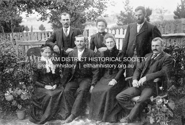
Photograph, Gulf Station, Yarra Glen. Members of the Bell Family, 1905c
... District Historical Society and Yarra Plenty Regional Library ...Mrs Bell and her adult children of Gulf Station, Yarra Glen. Standing Jack (John), Jemima, Andrew. Seated Mary Ann (mother of all the others), Frank (Francis), Dinah and Bill (William). Scottish settlers Agnes and William Bell were the first to lease the land where the property was established in the 1850s. Gulf Station was farmed for nearly 100 years by the Bell family.This photo forms part of a collection of photographs gathered by the Shire of Eltham for their centenary project book,"Pioneers and Painters: 100 years of the Shire of Eltham" by Alan Marshall (1971). The collection of over 500 images is held in partnership between Eltham District Historical Society and Yarra Plenty Regional Library (Eltham Library) and is now formally known as 'The Shire of Eltham Pioneers Photograph Collection.' It is significant in being the first community sourced collection representing the places and people of the Shire's first one hundred years.Digital imagesepp, shire of eltham pioneers photograph collection, yarra glen, bell family, gulf station, dianah bell, frank bell, jack bell, jimima bell, mary ann bell, william bell -
 Eltham District Historical Society Inc
Photograph postcard, Diamond Creek, Eltham; postcard dated 11 July 1906
View of the Diamond Creek as it enters the Yarra River, taken from the south side of ther Yarra.Digital file only Postcards scanned from the collection of Michael Aitken on loan to EDHS, 13 Feb 2018michael aitken collection, postcards, eltham, diamond creek, confluence -
Ringwood and District Historical Society
Map, Photocopy of Part of a map of Warrandyte -Yarra Valley area year unknown possibly c1930, c1930
Photocopy of Part of a map of Warrandyte -Yarra Valley area year unknown possibly c1930 -
 Ringwood and District Historical Society
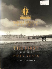
Book, Yarra Valley Grammar School - The First 50 Years - 1966-2015
History of Yarra Valley Grammar School, Kalinda Road, Ringwood. -
 Ringwood and District Historical Society
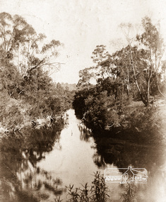
Photograph/Postcard, Yarra at Warrandyte. (undated)
Written on back of Postcard photograph, "Yarra at Warrandyte". undated -
Ringwood and District Historical Society
Envelope, Packet: Information re opening of Upper Yarra Reservoir and information re Yan Yean Reservoir
Correspondence; Souvenir of opening of Upper Yarra Reservoir; Historical surveys -
Ringwood and District Historical Society
Envelope, Packet: Yarra Valley Church of England School - Founding 1965, Papers, Opening, Land Sales etc
Yarra Valley Church of England School; Founding 1965; Building Appeal 1964, 1968; Service for unveiling and dedication of plaque; Service for opening of school; Notes on land sales -
 Ringwood and District Historical Society
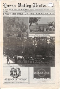
Newspaper, Yarra Valley Historical - A brief look at early life in the Yarra Valley during the mid 1800s to the 1900s (issued circa 2010)
Early History of the Yarra Valley (Vol l Issue 2) Coldstream, Yering, Christmas Hills, Steels Creek, Gulf Station, Toolangi, Tarrawarra, Healesville, Fernshaw, The Black Spur, Narbethong, Marysville. -
 Ringwood and District Historical Society
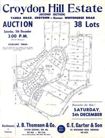
Flyer, Land Auction Sale Advertisement, Croydon Hill Estate, Croydon, Victoria - 1959
Single sided land auction sale advertisement for 38 residential allotments - Croydon Hill Estate (Second Section) Yarra Road, Croydon - corner Whitehorse Road. Auction Saturday, 5th December, and corresponding newspaper advertisement - Ringwood Mail, Thursday, November 26, 1959.Subdivision map includes Richardson Road, Yarra Road, Whitehorse Road, Alice Street, Hull Street (later Mulawa Stret). Auctioneers in Conjunction: J.B. Thomson & Co., Station Entrance, Box Hill, (Telephone) WX 1862, WX 7356, and at Nunawading, WU 1968, WU 3452, and C.E. Carter & Son, 126 Whitehorse Road, Ringwood. WU 6024. -
 Ringwood and District Historical Society
Photograph, Opening of Luther College, corner of Yarra Road and Plymouth Road, Croydon - February 1964
Written on back of photograph, "Opening new school, Yarra(?) Rd." Luther College, Feb 1964 -
 Ringwood and District Historical Society
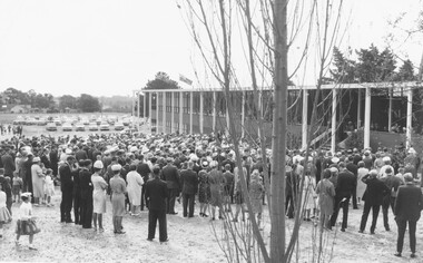
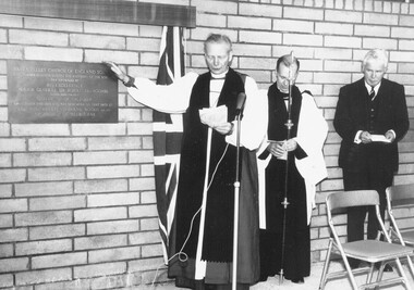
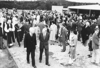
Photograph, Archbishop Frank Woods (left) and Sir Rohan Delacombe (right) pictured at Ringwood's Yarra Valley Church of England School dedication - October, 1965. The inscription on the plaque reads, "Yarra Valley Church of England School. This plaque commemorating the founding of the school was unveiled by His Excellency Major General Sir Rohan Delacombe, Governor of Victoria on October 2nd 1965 and was dedicated on that date by the Most Reverend Frank Woods, M.A., D.D., Archbishop of Melbourne"
The inscription on the plaque reads, "Yarra Valley Church of England School. This plaque commemorating the founding of the school was unveiled by His Excellency Major General Sir Rohan Delacombe ... Governor of Victoria on October 2nd 1965 and was dedicated on that date by the Most Reverend Frank Woods, M.A., D.D., Archbishop of Melbourne". -
 Ringwood and District Historical Society
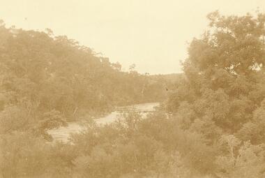
Photograph, Opening Yarra Valley (undated)
Written on backing sheet, "Opening Yarra Valley" -
 Marysville & District Historical Society
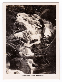
Photograph (item) - Black and white photograph, Rose Stereograph Company, Cora Lynn Falls, Marysville, 1913-1967
An early black and white photograph of the Cora Lynn Falls near Marysville in Victoria.An early black and white photograph of the Cora Lynn Falls near Marysville in Victoria. These falls are located on the Marysville-Wood's Point Road. Cambarville is notable for its giant mountain ash (Eucalyptus regnans) trees within the Cumberland Memorial Scenic Reserve, and relics from former sawmills and gold mining. The Big Culvert is located nearby on the Marysville - Woods Point Road, which was historically part of the Yarra Track. Cambarville was established as a timber mill town in the 1940s. Timber mill owners A Cameron and FJ Barton named Cambarville. They established the mill to salvage timber from trees destroyed in the 1939 bushfires. Cambarville was impacted by the 2009 Black Saturday bushfires and any remaining structures were destroyed. The photograph was also used to produce the Rose Series postcard P. 4947.marysville, victoria, photograph, cora lynn falls, waterfalls, rose series postcard, rose stereograph company, souvenir, cambarville, marysville-wood's point road, eucalyptus regnans, cumberland memorial scenic reserve, mining, big culvert, yarra track, a cameron, fj barton, 1939 bushfires, 2009 black saturday bushfires, timber mills, p. 4947 -
 Marysville & District Historical Society
Photograph (item) - Black and white photograph, Rose Stereograph Company, Nichol's Lookout, Marysville, 1913-1967
An early black and white photograph of the view from Nichol's Lookout which is on the Marysville-Wood's Point Road near Marysville, Victoria.An early black and white photograph of the view from Nichol's Lookout which is on the Marysville-Wood's Point Road near Marysville, Victoria. The photograph was also used to produce the Rose Series postcard P. 2324.marysville, victoria, photograph, nichol's lookout, marysville-wood's point road, p. 2324, rose series postcard, souvenir, rose stereograph company, wood's point, mining, yarra track -
 Marysville & District Historical Society
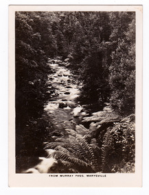
Photograph (item) - Black and white photograph, Rose Stereograph Company, From Murray Pass, Marysville, 1913-1967
An early black and white photograph of the Taggerty River from Murray Pass near Marysville, Victoria.An early black and white photograph of the Taggerty River from Murray Pass near Marysville, Victoria. Murray Pass is off the Lady Talbot Drive. Lady Talbot Drive a 24 kilometer scenic rainforest car journey which passes a number of walks and waterfalls in the Yarra Ranges National Park. Lady Talbot Drive is named after Lady Sarah Elizabeth, the wife of Sir Reginald Talbot, who was the Governor of Victoria from 25th April, 1904 to 6th July 1908.The photograph was also used to produce the Rose Series postcard P. 2309.marysville, victoria, photograph, taggerty river, murray pass, lady talbot forest drive, p. 2309, rose series postcard, souvenir, rose stereograph company, sir reginald talbot, lady sarah elizabeth talbot