Showing 5101 items
matching 1980
-
 Orbost & District Historical Society
books, 1938 - 1980
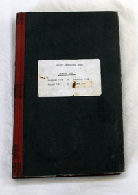
The Orbost Workers' Band and the Orbost Town Band amalgamated in 1913 to form the Orbost Municipal Band under the conductorship of Mr Charles Spink. The Orbost Municipal Band played a major role in the Orbost community activities. Charles Spink made sure each soldier returning home from the 1914 to 1918 war was welcomed home in front of the Shire Hall to the music of the Orbost Municipal Band. The band played in the main street on most Friday nights and in 1929 the band played at the official opening of the Buchan Caves, by Sir Albert Lind. The various Orbost bands over the years played a major role in community activities providing entertainment and musical experiences for the many members.Two hard back minute books with black covers and red spines. There is a white paper label with details of dates and the title "ORBOST MUNICIPAL BAND MINUTE BOOK".orbost-municipal-band -
 Orbost & District Historical Society
Red Cross badge and membership card, 1980's
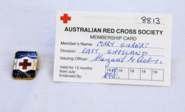
The Australian Red Cross Society (ARCS) was formed just after the outbreak of the First World War in August 1914, initially as a branch of the British Red Cross Society. Its first president was Lady Helen Munro Ferguson, wife of the then governor-general. Via a network of state branches and division, also presided over by women, the organisation extended its influence throughout the community of Australian women, urban and rural. Mary Gilbert was the first curator of the Orbost Museum, and a local teacher.Mary Gilbert was the Orbost Red Cross Superintendent. She was a long time member of Red Cross.Mary Gilbert was a member of Red Cross for over 40 years. She was a noted Orbost identity.1518.1 is a rectangular brass and blue, white and red enamelled badge. The badge shows a red cross in the centre and the words 'RED CROSS EMERGENCY SERVICE'. The reverse has a pin fastening. 1518.2 is a yearly Red Cross membership card. 1518.1 front- Red Cross Emergency Service 1518.2 - Membership Number -8813 Mary Gilbert, East Gippsland 26/12/1988 red-cross membership-card badge -
 Orbost & District Historical Society
fridge magnet, C 1980's -1990's
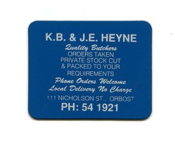
Used as publicity/advertising item by Ken Heyne, butcher in Orbost.Fridge magnets are popular as promotional items because they are relatively cheap to manufacture, very portable and long-lasting. This item advertises a local business no longer operating.A small, rectangular, flat fridge magnet. One side is dark blue with white print - "K.B.& J.E. HEYNE Quality Butchers ORDERS TAKEN PRIVATE STOCK CUT & PACKED TO YOUR REQUIREMENTS Phone orders welcome Local DElivery No Charge 111 Nicholson St Orbost Ph 541921". The reverse is grey/black. fridge-magnet advertising-orbost -
 Orbost & District Historical Society
brochure, Come To Orbost, c 1980's
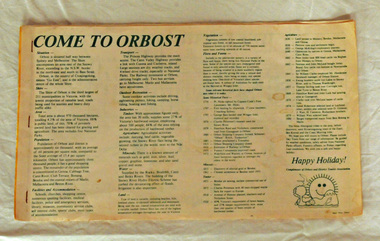
This brochure was produced as a tourist guide to Orbost.This item is a useful research tool.A magazine/brochure for use as tourist information. It contains the history, maps and touring routes of the Orbost district.tourism-orbost -
 Orbost & District Historical Society
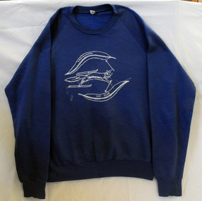
windcheater, Merritt Hassett, 1980
Bulk orders were made of these windcheaters in various sizes for students and staff at the school. They were worn as part of the sports uniform and also the school uniform.Orbost High School / Orbost Secondary College has played a significant role in the education of senior students in the district. It is the sole institution for secondary education. This item is representative of its history.A commercially manufactured navy blue long-sleeved jumper with Orbost High School badge embroidered on the front in yellow/gold colouring.Orbost High School - Acti Labores Iucundiuniform orbost-high-school -
 Orbost & District Historical Society
jumper, 1970's -1980's
This jumper was worn by John Court as an employee of Orbost Shire Council. Orbost was at first included in the Bairnsdale Shire from 1882 and was later part of the Tambo Shire. Because of travelling distances the Croajingalong Shire was created in 1892 (name changed to Orbost Shire 17.2.1893 with James Cameron as the first Shire President. In 1994 it amalgamated to become part of East Gippsland Shire Council.Local governments play an important role in the lives of citizens in Australia. Local government authorities exist to provide services and amenities to local communities, and are also responsible for regulating and providing services for land and property in their district. This item is representative of a time when Orbost had its own Shire Council.A fawn coloured V - necked long-sleeved woollen jumper. It has a waratah emblem embroidered in red with green leaves. Below this is embroidered the word ORBOST in gold.uniform jumper orbost-shire-council court-john -
 Orbost & District Historical Society
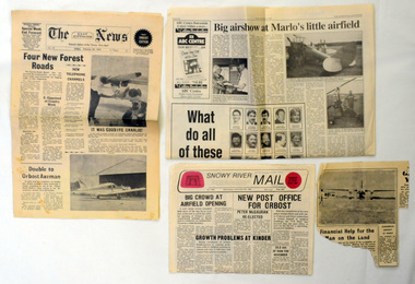
newspaper clippings, 1970's-1980's
These articles were collected by David Nixon for the Orbost Aero Club. Orbost Aero Club began in 1969 with Basil Dowie as Chair, David Nixon as Secretary/Treasurer. The group went into recess from 1977-1991 closing in 1997. The mid 1960s were boom years in flying training in Australia and the number of Aero Clubs grew rapidly. The Club played a significant role in the establishment of the small airport at Marlo and in the ongoing operation and development of the airport over the years particularly for patient transfer by aerial ambulance. The Orbost Aero Club Club played a significant role in the establishment of the small airport at Marlo and in the ongoing operation and development of the airport over the years.A colection of newspaer cuttings which pertain to the Orbost / Marlo Aerodrome.orbost-aero-club marlo-airport -
 Orbost & District Historical Society
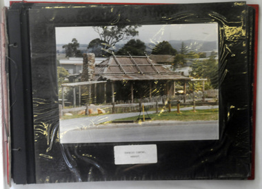
albums, late 1980's
These two albums were used at the Slab Hut - Orbost Visitor Information Centre. The Orbost Visitor Information Centre is situated in Forest Park on Nicholson Street. The centre is housed in the historic Slab Hut. The hut was an original family dwelling built in 1872, on a site approximately three kilometres upstream from the junction of the Buchan and Snowy Rivers. No nails were used in the construction; it was all wired together. After a period in storage the slab hut was opened in its present location in Orbost as the Information Centre in 1987.These albums are contemporary records of the construction and relocation of an iconic Orbost building, the Slab Hut.Two large photo albums. 2280.1 has no front cover. The back cover and spine are red. The pages are black and most photos are labelled. They are photographs of the Orbost area. 2280.2 has brown covers. It contains photographs of the construction of the gardens and buildings around the Slab Hut (Orbost Visitor Information Centre). On the cover in gold print is "PHOTOS".slab-hut-orbost album-photographs-orbost -
 Orbost & District Historical Society
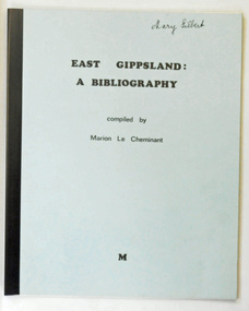
book, East Gippsland a Bibliography, June 1980
This is a useful reference tool.Two copies of a 29 pp soft covered book. The front cover is pale blue with a black plastic spine. In black text is the title "East Gippsland : A Bibliography" above "compiled by Marion Le Cheminant". At the bottom centre is "M" . This is a resource guide for bookks about East Gippsland. The cost is noted as $2.50.2289.1 - on front cover "Mary Gilbert" in black ink. 2289.2 - on front cover "M.Brunt" in black penle-cheminant-marion east-gippsland-bibliography -
 Orbost & District Historical Society
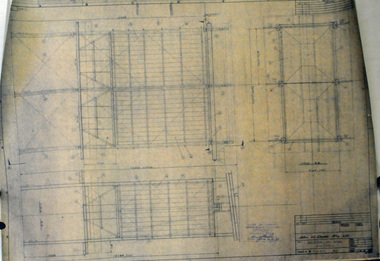
plans, Elliott Engineering Company Pty Ltd, 1980
These plans were used by POW Sawmills, Newmerella, probably owned at the time by Henry's Timber Company. Hec Pow and his father sold the Newmerella mill to Henry Silverberg and Les Grace. The mill is currently owned by Mectec.Orbost has historically been based on the timber industry, but that industry has declined considerably over the last 20 years. The number of locals involved in the timber industry has declined and many of the mills have closed. This item reflects a time when that industry was a significant contributor to the economy of the district.Eight large plans for various sections of POW's at Newmerella. The plans were drawn up for Bonang Timbers and Bowman.2317.2 - on back in pen "REC 24/9/80" 2317.3 - on back in red pen "INCOMPLETE SET OF PLANS" ; sticker with "Shire of Orbost Compulsory Inspection" 2317.5 - "DODD" in red ink (John H. Dodd Pty Ltd) -
 Orbost & District Historical Society
jumper, 1970's - 1980's
The jumper was owned by John Court, a previous employee of Orbost Shire Council.A blue cotton/polyester long-sleeved jumper. It is fleecy lined. On the front is painted a picture of a fox on skis holding ski poles. at the top is a gumleaf with ERRINUNDRA inside. Below the fox is a gumleaf with SKI CLUB inside the leaf. This is in white. On the label is Size 110cm.clothing jumper court-john errinundra-ski-club recreation -
 Orbost & District Historical Society
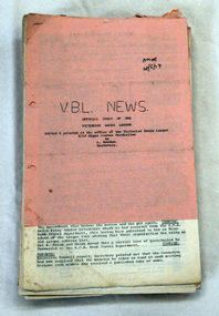
magazines, Victorian Band League, VBL News, January 1976 -1980
Since 1931 The VBL has been the association of amateur community bands in Victoria, Australia. Its members are brass, concert and stage bands. The VBL provides competition, training and representation for its members. Individuals members are registered directly with the League.The various Orbost bands over the years played a major role in community activities providing entertainment and musical experiences for the many members.Forty newsletters. Paper-backed VBL News. All printed on quarto sized white paper.music newsletters brass-bands vbl -
 Orbost & District Historical Society
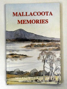
book, Mallacoota Memories, 1980
This book was produced by the Mallacoota and District Historical Society. The Society, founded in 1974, has a museum housed in a World War 2 Bunker in Mallacoota . The bunker was handed over to the Society by the R.S.L.A small 104 pp book titled Mallacoota Memories. On the front cover is a coloured photo of lakes and trees. The title is in red. The book contains early observations by J.[G] A. Robinson; contact with settlers; mentions Biduelli, Kruatungulung, Murring, Ben- Kurnai, Mallekotang Mittong, Tinnon, Kyrekong, Ponedyang, Worarer Mittong groups. The history is from 1841 -1945. It was produced by Mallacoota and District Historical Society.mallacoota-history robinson-j.a -
 Warrnambool and District Historical Society Inc.
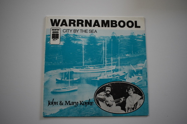
Audios, 45rpm Warrnambool, City by the Sea Warrnambool by the sea x 2, 1980
These records of two songs sung by John and Mary Kopke, has been made as a souvenir of Warrnambool during the time it won the Premier Town Award 1979-1982. This award was given to a town or city that showed excellence in official environmental practice. The promotion song, ‘City By the Sea’ celebrates Warrnambool and mentions the May Racing Carnival with its Grand Annual Steeple Race, the Melbourne to Warrnambool Cycle Race and Flagstaff Hill Maritime Museum. The other song is about the Mahogany Ship, a ship that was first found wrecked on the coast near Warrnambool in 1836. There were many sightings of the wreck until the 1890s when it disappeared. There has been speculation ever since about the ship’s origins – Spanish? Portuguese? Chinese? The search for the wreck continues. This record is an interesting one – a memento of the celebrations in Warrnambool during the time it won the Premier Town Award 1979-1982. These are two identical records. .1 This is a paper cover for a 45 R.P.M. record. It has black printing, the logo of Warrnambool Premier Town, a blue-coloured image of the harbour at Flagstaff Hill Maritime Museum Warrnambool with an inset black and white photograph on one side and a blue-coloured image of the Mahogany Ship and black printing on the other side. .2 This is 45 R.P.M. record with recordings on both sides and inset with black printing on an aqua background. ‘Warrnambool City By the Sea’ ‘The Ship Mahogany’ ‘John and Mary Kopke’ warrnambool premier town 1979-82, mahogany ship, john and mary kopke -
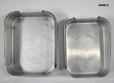 Bendigo Military Museum
Equipment - DIXIES, Department of Defence, 1) June 1980. .2) may 1970
Australian Army Pattern issue Mess tins, one fits inside the other..1) Small oblong aluminium tray with folding handles. .2) Large oblong aluminium tray with folding handles..1) Stamped on, “7350 - 66 - 014 - 5895 - SMP/Y 6/80” .2) Stamped on, “7350 - 66 - 014 - 5895 - SMP/Y 5/70”mess tins, dixies -
 Bendigo Military Museum
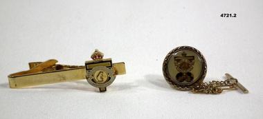
Accessory - TIE PINS, Rats of Tobruk Association, c.1980
See Dean Cat 4575P1. Gold metallic bar. The enamelled badge of Rats of Tobruk Association is mounted at one end. The rear of tie bar has a spring loaded clamp. 2. Gold tie pin with mini chains. This is of circular design with the badge of Rats of Tobruk Association sealed in it behind an acrylic layer. Below the Rats badge are two world spheres. Small chains and two pins come away from rear of badge.tie pins, rats of tobruk -
 Bendigo Military Museum
Headwear - HAT, SLOUCH, C.1980 - 90
Item issued to Graham Wybar Regt No 317089.Slouch hat khaki fur felt with lighter pugaree head band and colour patch green on yellow square with darker green oval centreheadwear, slouch hat, army -
 Bendigo Military Museum
Accessory - EPAULETTES, C.1980 -90’s
Items belonged to Capt L. Elliott, Royal Australian Army Nursing Corp, refer Cat No 4308 TRIA JUNCTA IN UNO meaning basically, “Faith, Hope Charity” .1).2) Epaulettes, light khaki colour polyester covers over plastic base with 3 metal insignia pips and metal RAANC badges. 3) Piece of grey coloured card with 6 rank insignia pips on.Insignia pips have on, “TRIA JUNCTA IN UNO” rank, insignia, epaulettes, pips -
 Bendigo Military Museum
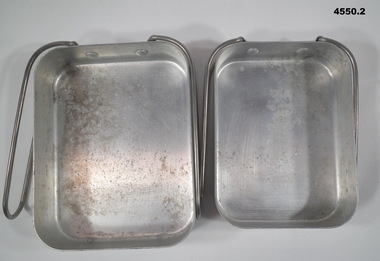
Equipment - DIXIE SET, Department of defence, June 1980
Military issue as part of a soldiers kit and equipment.1) Dixie, large, aluminium, rectangular shape, two handles that swing around to store away, details stamped on one end. .2) Dixie, same as .1) but smaller and fits inside .1) for storage..1) Stamped on handle end, "7350 - 66 - 014 - 5895, SMP (over) V (arrow up) 6/80". .2) Same as .1)dixies, mess set -
 Bendigo Military Museum
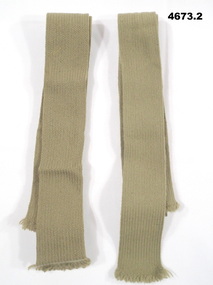
Uniform - TIES, C. 1960 - 1980
Military issue ties, frayed ends result from each being cut from a large roll. Peter Dodd collection, refer Cat No 2436.2P.1).2) Ties, khaki colour, wool, the ends on are frayed.ties, uniform -
 Bendigo Military Museum
Uniform - RANK INSIGNIA, C.1960 - 1980
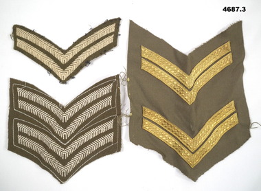
.1) is as used for Corporal, .2).3) these can be cut to make two sets of Corporal stripes, .1).2) these are work dress for Greens, .3) these are for Service Dress. Peter Dodd collection, refer Cat No 2436.2P.1) Rank insignia “Corporal”, dark brown with 2 off white “V” shape stripes. .2) Rank insignia same as in .1) except has 2 sets of Corporal stripes. .3) Rank insignia, 2 sets brown back ground with Gold Corporal stripes.rank insignia, corporal, accessory, uniforms -
 Eltham District Historical Society Inc
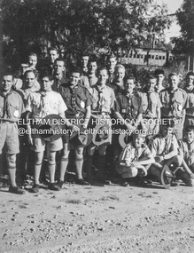
Photograph - Black and White Print, Lewis Tulk, Yarra Batman Area Scout Stage III training at 1st Eltham Scout Hall, Youth Road, Eltham, c.1980
In the background a 'Red Rattler' Tait train is visible at Eltham Railway Station. Donated by Lewis Tulk, former Scout Area Training Commisioner for Leaders.Inscribed on reverse: YBA Scout Stage III 1st Eltham Scout Hallscouts victoria, scout leader training, lewis tulk collection, 1st eltham scouts, eltham, red rattler, tait train, yarra batman area, youth road -
 Eltham District Historical Society Inc
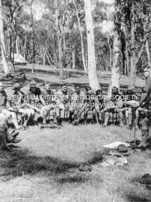
Photograph - Black and White Print, Lewis Tulk, Yarra Batman Area Scout Stage III training at Meruka Park, Eltham, c.1980
Scout training course held at Meruka Park Lewis Tulk was Training Commisioner for YBA training leaders Pictured is Vern Brookes Area Commissioner for Scouts Donated by Lewis Tulk, former Scout Area Training Commisioner for Leaders.scouts victoria, scout leader training, lewis tulk collection, eltham, yarra batman area, meruka park, vern brookes -
 Queenscliffe Maritime Museum
Letter 9'4'1979 & newspaper clippings re QMM, Borough of Q'cliffe Ltr to Point Lonsdale Civic Association, dated 9/4/1979, 1980 onwards
Provision of marine life saving services displayProtest letter about the provision marine life saving services and various newspaper reportsProtest letter re the provision of life saving services and several newspaper clippings about QMM & its displaysReverse - " N/A "historical references -
 Eltham District Historical Society Inc
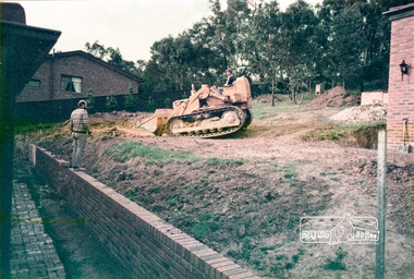
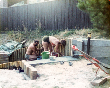
Photograph, 14 Stokes Place, Eltham, 1982, 1980
14 Stokes Place was the home of Peter and Carla Vermey. The land was purchased in May 1979 and the home built by Peter and Carla Vermey after the developer, Macquarie Builders went bankrupt. Sold October 2017 by Morrison and Kleeman Real Estate. Stokes Place was part of the Stokes Orchard Estate which was developed from the break-up of the the orchard owned by Frank Stokes who lived on the northeast corner of Nyora Road and Eucalyptus Road. His daughter Beryl advised that the Shire had levied a rate assessment on individual parcels of land within the orchard which became unaffordable resulting in its sub-division and sell off. The Stokes Orchard Estate was developed by Macquarie Builders in two stages starting with stage 1 in 1976. Stokes Place was part of Stage 2 in 1979. The Estate was bounded between Nyora Road, Eucalyptus Road, Diosma Road and Stokes Place. The original orchard only just reached the left most portions of Stokes Place and did not go fully up to Diosma, rather to just beyond the extant of Stokes Place. Stokes Place was known within the family as "The Oats" as that is where they grew oats. Frank Stokes moved to Eltham c.1945 after visiting Harold Bird to view his orchard, located diagonally opposite Stokes Orchard from the intersection of Eucalyptus Road, Pitt Street and Nyora Road. It was on Harold Bird's recommendation that Frank purchased the land.The Stokes Orchard Estate collection is typical of housing developments of the late 1970s and 1980s. It was one of the earliest estates in Eltham following the nearby Woodridge Estate development.Digital fileScanned from a print contained in owner's photo album (81 prints in total digitised)stokes place, eltham, stokes orchard, stokes orchard estate, streets, houses, peter and carla vermey -
 Eltham District Historical Society Inc
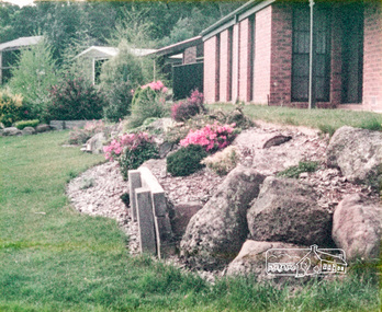
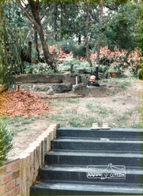
Photograph, 14 Stokes Place, Eltham, October 1983, 1980
14 Stokes Place was the home of Peter and Carla Vermey. The land was purchased in May 1979 and the home built by Peter and Carla Vermey after the developer, Macquarie Builders went bankrupt. Sold October 2017 by Morrison and Kleeman Real Estate. Stokes Place was part of the Stokes Orchard Estate which was developed from the break-up of the the orchard owned by Frank Stokes who lived on the northeast corner of Nyora Road and Eucalyptus Road. His daughter Beryl advised that the Shire had levied a rate assessment on individual parcels of land within the orchard which became unaffordable resulting in its sub-division and sell off. The Stokes Orchard Estate was developed by Macquarie Builders in two stages starting with stage 1 in 1976. Stokes Place was part of Stage 2 in 1979. The Estate was bounded between Nyora Road, Eucalyptus Road, Diosma Road and Stokes Place. The original orchard only just reached the left most portions of Stokes Place and did not go fully up to Diosma, rather to just beyond the extant of Stokes Place. Stokes Place was known within the family as "The Oats" as that is where they grew oats. Frank Stokes moved to Eltham c.1945 after visiting Harold Bird to view his orchard, located diagonally opposite Stokes Orchard from the intersection of Eucalyptus Road, Pitt Street and Nyora Road. It was on Harold Bird's recommendation that Frank purchased the land.The Stokes Orchard Estate collection is typical of housing developments of the late 1970s and 1980s. It was one of the earliest estates in Eltham following the nearby Woodridge Estate development.Digital fileScanned from a print contained in owner's photo album (81 prints in total digitised)stokes place, eltham, stokes orchard, stokes orchard estate, streets, houses, peter and carla vermey -
 Eltham District Historical Society Inc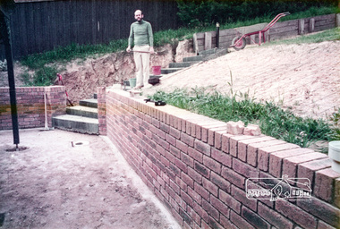
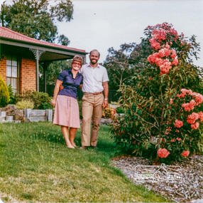
Photograph, Carla and Peter Vermey, 14 Stokes Place, Eltham, February 1984, 1980
14 Stokes Place was the home of Peter and Carla Vermey who had migrated to Australia from Holland. The land was purchased in May 1979 and the home built by Peter and Carla Vermey after the developer, Macquarie Builders went bankrupt. Sold October 2017 by Morrison and Kleeman Real Estate. Stokes Place was part of the Stokes Orchard Estate which was developed from the break-up of the the orchard owned by Frank Stokes who lived on the northeast corner of Nyora Road and Eucalyptus Road. His daughter Beryl advised that the Shire had levied a rate assessment on individual parcels of land within the orchard which became unaffordable resulting in its sub-division and sell off. The Stokes Orchard Estate was developed by Macquarie Builders in two stages starting with stage 1 in 1976. Stokes Place was part of Stage 2 in 1979. The Estate was bounded between Nyora Road, Eucalyptus Road, Diosma Road and Stokes Place. The original orchard only just reached the left most portions of Stokes Place and did not go fully up to Diosma, rather to just beyond the extant of Stokes Place. Stokes Place was known within the family as "The Oats" as that is where they grew oats. Frank Stokes moved to Eltham c.1945 after visiting Harold Bird to view his orchard, located diagonally opposite Stokes Orchard from the intersection of Eucalyptus Road, Pitt Street and Nyora Road. It was on Harold Bird's recommendation that Frank purchased the land.The Stokes Orchard Estate collection is typical of housing developments of the late 1970s and 1980s. It was one of the earliest estates in Eltham following the nearby Woodridge Estate development.Digital fileScanned from a print contained in owner's photo album (81 prints in total digitised)stokes place, eltham, stokes orchard, stokes orchard estate, streets, houses, peter and carla vermey -
 Eltham District Historical Society Inc
Photograph, Carla and Peter Vermey, 14 Stokes Place, Eltham, March 1984, 1980
14 Stokes Place was the home of Peter and Carla Vermey who had migrated to Australia from Holland. The land was purchased in May 1979 and the home built by Peter and Carla Vermey after the developer, Macquarie Builders went bankrupt. Sold October 2017 by Morrison and Kleeman Real Estate. Stokes Place was part of the Stokes Orchard Estate which was developed from the break-up of the the orchard owned by Frank Stokes who lived on the northeast corner of Nyora Road and Eucalyptus Road. His daughter Beryl advised that the Shire had levied a rate assessment on individual parcels of land within the orchard which became unaffordable resulting in its sub-division and sell off. The Stokes Orchard Estate was developed by Macquarie Builders in two stages starting with stage 1 in 1976. Stokes Place was part of Stage 2 in 1979. The Estate was bounded between Nyora Road, Eucalyptus Road, Diosma Road and Stokes Place. The original orchard only just reached the left most portions of Stokes Place and did not go fully up to Diosma, rather to just beyond the extant of Stokes Place. Stokes Place was known within the family as "The Oats" as that is where they grew oats. Frank Stokes moved to Eltham c.1945 after visiting Harold Bird to view his orchard, located diagonally opposite Stokes Orchard from the intersection of Eucalyptus Road, Pitt Street and Nyora Road. It was on Harold Bird's recommendation that Frank purchased the land.The Stokes Orchard Estate collection is typical of housing developments of the late 1970s and 1980s. It was one of the earliest estates in Eltham following the nearby Woodridge Estate development.Digital fileScanned from a print contained in owner's photo album (81 prints in total digitised)stokes place, eltham, stokes orchard, stokes orchard estate, streets, houses, peter and carla vermey -
 Eltham District Historical Society Inc
Photograph, 14 Stokes Place, Eltham, March 1984, 1980
14 Stokes Place was the home of Peter and Carla Vermey who had migrated to Australia from Holland. The land was purchased in May 1979 and the home built by Peter and Carla Vermey after the developer, Macquarie Builders went bankrupt. Sold October 2017 by Morrison and Kleeman Real Estate. Stokes Place was part of the Stokes Orchard Estate which was developed from the break-up of the the orchard owned by Frank Stokes who lived on the northeast corner of Nyora Road and Eucalyptus Road. His daughter Beryl advised that the Shire had levied a rate assessment on individual parcels of land within the orchard which became unaffordable resulting in its sub-division and sell off. The Stokes Orchard Estate was developed by Macquarie Builders in two stages starting with stage 1 in 1976. Stokes Place was part of Stage 2 in 1979. The Estate was bounded between Nyora Road, Eucalyptus Road, Diosma Road and Stokes Place. The original orchard only just reached the left most portions of Stokes Place and did not go fully up to Diosma, rather to just beyond the extant of Stokes Place. Stokes Place was known within the family as "The Oats" as that is where they grew oats. Frank Stokes moved to Eltham c.1945 after visiting Harold Bird to view his orchard, located diagonally opposite Stokes Orchard from the intersection of Eucalyptus Road, Pitt Street and Nyora Road. It was on Harold Bird's recommendation that Frank purchased the land.The Stokes Orchard Estate collection is typical of housing developments of the late 1970s and 1980s. It was one of the earliest estates in Eltham following the nearby Woodridge Estate development.Digital fileScanned from a print contained in owner's photo album (81 prints in total digitised)stokes place, eltham, stokes orchard, stokes orchard estate, streets, houses, peter and carla vermey