Showing 25665 items
matching plenty-township-estate
-
 Canterbury History Group
Ephemera - Convenience and location, [2004]
Real estate advertisement for the sale by auction of 3/28 Faversham Road Canterbury on Saturday 27 November[2004]. Includes coloured photographs of the exterior and interior of the building.canterbury, faversham road, home units -
Canterbury History Group
Ephemera - Excellence in design and presentation, {1997 or 2003}
Real estate advertisement for the sale by auction of 27 Hopetoun Avenue Canterbury on Saturday 13 September [1997 or 2003]. Includes a sketch of the house and floor and site planscanterbury, hopetoun avenue, townhouses -
Canterbury History Group
Ephemera - Superb edwardian, moments from Maling Road, 1/02/2011 12:00:00 AM
Real estate advertisement from the Weekly Review for the auction on 26 February 2011 of 22 Milton Street Canterbury.Includes coloured photograph of the interior, exterior and the swimming p.oolcanterbury, milton street, edwardian style, swimming pools, timber houses -
Canterbury History Group
Ephemera - Elite contemporary quality, 1/02/2011 12:00:00 AM
Real estate advertisement from the Weekly Review for the auction on 26 February 2011 of 2/25 Chatham Road Canterbury. Includes coloured photographs of the interior and exterior.canterbury, chatham road, townhouses -
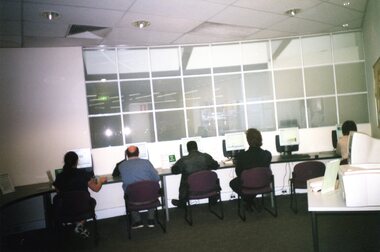 Greensborough Historical Society
Photograph - Photographs, Rosie Bray, Watsonia Library: Computer users at Watsonia Library, 2005
Watsonia Library is a branch of Yarra Plenty Regional Library Service (YPRL). Photographs of computer users at the libraryColour photographyarra plenty regional library, yprl, watsonia library -
 Greensborough Historical Society
Article - Article, Book, Dianne Edwards, Turner Brothers Bakery, 1978
Account of Turner Brothers bakery, built in the 1880s on the Plenty Road at South Yan Yean (now Mernda)1 p. text and photographyan yean, mernda, turners bakery, turner family -
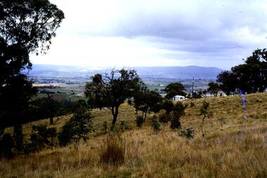 Greensborough Historical Society
Slide - Photograph, John Ramsdale, Rural landscape Mill Park: Slide 9
Photograph shows a rural landscape with a few buildings, possibly east of Plenty Road near Mill Park.Part of the John Ramsdale collection of slides and audio visual material.Colour photograph scanned from slide.No maker's marks. No caption on slide.mill park -
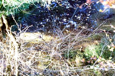 Greensborough Historical Society
Slide - Photograph, John Ramsdale, Sprayed blackberries: Slide 18, 1990s
Photograph shows sprayed and dead blackberries on the bank of the Plenty River; behind factories on Para Road Montmorency.Part of the John Ramsdale collection of slides and audio visual material.Colour photograph scanned from slide.No maker's marks. No caption on slide.plenty river, weeds, blackberries, para road montmorency -
 Greensborough Historical Society
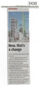
Newspaper Clipping, Diamond Valley Leader, Now, that's a change, 28/03/2018
Out with the old and in with the new. Boom gates at Rosanna Station on Lower Plenty Road have been removedNews article 1 page, black text and colour image .hurstbridge rail line upgrade, rosanna station, lower plenty road rosanna, hurstbridge rail line -
 Greensborough Historical Society
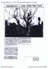
Article, Argus (newspaper), Preserving a link with the past, 08/09/1937
1937 article describing the Apple Tree on Plenty River at Greensborough, its possible origins and steps to preserve it.Early attempts to preserve the Batman Apple Tree and alternative explanations of its origins.Downloaded copy of article. Text and b&w photo. batman apple tree, flintoff, plenty river, greensborough -
 Greensborough Historical Society
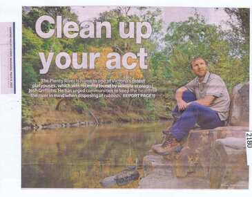
Newspaper clipping, Clean up your act, 04/03/2015
Ecologist Josh Griffiths recently found a platypus in the Plenty River and urges the community to keep the river clean.News clipping, black text, colour image.plenty river, platypus, josh griffiths -
 Greensborough Historical Society
Newspaper Clipping, Diamond Valley Leader, Bust to boom in two years, 30/11/2016
Yarra Plenty Swimming Club was named Victoria's Club of the Year under head coach Paul Schindler.News clipping, black text and colour image. yarra plenty swimming club, paul schindler -
 Greensborough Historical Society
Photograph - Digital Image, Blue Lake: Views of lake, 19/06/2015
Blue Lake is in Yellow Gum Park in the Plenty Gorge, north of Greensborough. These photos show views of the lake.Digital copy of colour photographsyellow gum park, blue lake, plenty gorge park -
 Greensborough Historical Society
Photograph - Digital image, Marilyn Smith, Blue Lake: More views of the lake, 19/06/2015
Blue Lake is in Yellow Gum Park in the Plenty Gorge, north of Greensborough. These photos show views of the lake.Digital copy of colour photographsyellow gum park, blue lake, plenty gorge park -
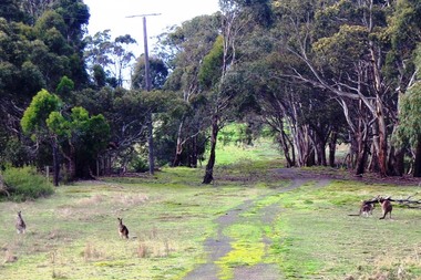 Greensborough Historical Society
Photograph - Digital image, Marilyn Smith, Blue Lake: Kangaroos at Yellow Gum Park, 19/06/2015
Blue Lake is in Yellow Gum Park in the Plenty Gorge, north of Greensborough. These photos show kangaroos in the Park.Digital copy of colour photographsyellow gum park, blue lake, plenty gorge park -
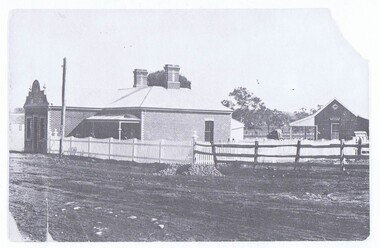
 Orbost & District Historical Society
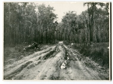
black and white photograph, 1924
This photograph shows the main road near Bellbird, East Gippsland, in 1924. This road would have been the Princes Highway, a main thoroughfare through to New South Wales. Bellbird Creek is a small rural location between Orbost and Cann River. There was no township at Cabbage Tree at this time. The Cabbage Tree Creek township was established to support the booming timber industry of the mid 20th century. Five timber mills worked full time supporting the families that were drawn to the area's wealth of natural resources. Nestled on the banks of the Cabbage Tree Creek, the township was built by those mills to house their workers. Today although the timber mills have disappeared, some of the buildings still remain. Little now remains to remind of the saw-milling history apart from photographs and some relics - a boiler and a brick furnace. There was also a thriving agricultural community farming dairy, beef, seed beans and fresh peas and beans that were sent to the Victoria Market in Melbourne. Dairy farming still plays an essential role in the township. this is a pictorial record of the Princes Highway, the main road from East Gippsland to the New South Wales border.A large black / white photograph of a very wet and boggy bush road.on front - "Main Rd near Bellbird 1924"road princes-highway bellbird-creek-1924 -
 Ringwood and District Historical Society
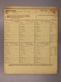
Administrative record - Rate Books, Borough of Ringwood Valuation & Rate Cards for 1944-49 (Assessments 3254-7 & 636), March 2012
Originally stored at Ringwood Council offices, then taken to PROV.Only source of ratepayers in the Borough of RingwoodDigital imagesBedford Road, Ringwood. For Osmond Wickham, Frances Howe, Jefferey & Roma Forbes-Ewan & Jefferey & Roma Forbes-Ewan (Colman Estate). -
 Ringwood and District Historical Society
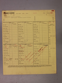
Administrative record - Rate Books, Borough of Ringwood Valuation & Rate Cards for 1944-49 (Assessments 3198-3202), March 2012
Originally stored at Ringwood Council offices, then taken to PROV.Only source of ratepayers in the Borough of RingwoodDigital imagesBarkly Street, Ringwood. For Constance & William Hall, William Hancock (Allman's Estate), Lilian Gawith, James McDonald & John & Beryl Albert. -
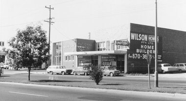 Ringwood and District Historical Society
Photograph, Maroondah Highway West, Ringwood- 1969. Near Wantirna Road
Black and white photographWritten on back of photograph: "May 1969" Image shows 'National Bank', and 'Newman & Ritchie Estate Agents' on south side of Maroondah Highway. -
Port Melbourne Historical & Preservation Society
Photograph - Walls erected for public housing section of Bayside Project, Port Melbourne, The Emerald Hill, Sandridge and St Kilda Times, 1991
Black and white photocopy of photograph from "The Emerald Hill and Sandridge Times"of walls erected for public housing section of Bayside Project"Slab construction in Princes Street 1991. Port has 11 Housing Commission estates, much higher proportion than other areas."built environment - domestic, built environment - public housing, bayside project, princes street, housing commission of victoria -
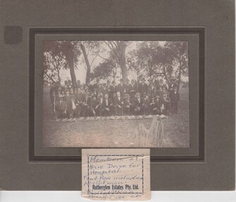 Rutherglen Historical Society
Photograph, 1920 (Approximate)
Rev. Watts in groupPhotograph of a group of men, seated & standing, with line of dead hares. Mounted. Unframed."Hare Drive For / Hospital / Front Row Includes / Les Gillman / Rutherglen Estates Pty Ltd / Walter McRae / Frank Fuge, etc."hare drive, les gillman, walter mcrae, frank fuge -
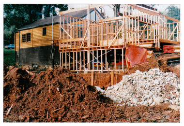 Marysville & District Historical Society
Photograph (Item) - Colour photograph, Unknown
A colour photograph taken during the construction of Arbor Green Cottage in Marysville. This cottage, along with most of the buildings in the township, was destroyed in the 2009 Black Saturday bushfires.A colour photograph taken during the construction of Arbor Green Cottage in Marysville.1 Falls Rd M'sville./ The future ahead./ The Arbor Green Galleries/ 3 Levels.marysville, victoria, australia, photograph, accommodation, arbor green cottage, 2009 black saturday bushfires -
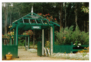 Marysville & District Historical Society
Photograph (Item) - Colour photograph, 1992
A colour photograph of the garden entrance and bridge at Arbor Green Gardens in Marysville. This cottage, along with most of the buildings in the township, was destroyed in the 2009 Black Saturday bushfires.A colour photograph of the garden entrance and bridge at Arbor Green Gardens in Marysville.Garden Entrance & bridge./ Arbor Green Galleries/ 1 Falls Rd. M'sville./ Spring 1992marysville, victoria, australia, photograph, accommodation, arbor green cottage, 2009 black saturday bushfires -
 Marysville & District Historical Society
Photograph (Item) - Colour photograph, Unknown
A colour photograph of the front facade and garden of Arbor Green Galleries in Marysville. This cottage, along with most of the buildings in the township, was destroyed in the 2009 Black Saturday bushfires.A colour photograph of the front facade and garden of Arbor Green Galleries in Marysville.1 Falls Rd M'sville./ Arbor Green Galleries & Cottage.marysville, victoria, australia, photograph, accommodation, arbor green cottage, 2009 black saturday bushfires -
 Marysville & District Historical Society
Photograph (Item) - Colour photograph, 1992
A colour photograph of the front pergola at the entrance to Arbor Green Galleries in Marysville. This cottage, along with most of the buildings in the township, was destroyed in the 2009 Black Saturday bushfires.A colour photograph of the front pergola at the entrance to Arbor Green Galleries in Marysville.1 Falls Rd M'sville./ Arbor Green Galleries & Cottage.marysville, victoria, australia, photograph, accommodation, arbor green cottage, 2009 black saturday bushfires -
 Marysville & District Historical Society
Photograph (Item) - Colour photograph, Unknown
A colour photograph of the sitting room in the cottage at Arbor Green Galleries and Cottage. This cottage, along with most of the buildings in the township, was destroyed in the 2009 Black Saturday bushfires.A colour photograph of the sitting room in the cottage at Arbor Green Galleries and Cottage.1 Falls Rd. M'sville./ Cottage Sitting Room.marysville, victoria, australia, photograph, accommodation, arbor green cottage, 2009 black saturday bushfires -
 Marysville & District Historical Society
Photograph (Item) - Colour photograph, Unknown
A colour photograph of one of the cottages at Amber View Cottages in Marysville. These cottages, along with most of the buildings in the township, were destroyed in the 2009 Black Saturday bushfires.A colour photograph of one of the cottages at Amber View Cottages in Marysville.amber view cottages, marysville, victoria, australia, accommodation, photograph, 2009 black saturday bushfires -
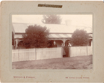 Hume City Civic Collection
Photograph, c1907
Members of the Fanning family standing outside their house 'Sunnyside', in Loemans Road, Bulla. The Fannings were one of the early European families to settle in the Bulla township. A black and white mounted photograph of the Fanning family in front of a cottage with a picket fence.Printed on face: Matson and Frazer / 264 Little Collins Street Handwritten on back: Eric Boardmanmatson and frazer, photographers, eric boardman collection, fanning family, george evans collection -
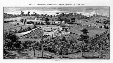 Eltham District Historical Society Inc
Photograph, Samual Calvert, Eltham, The Illustrated Australian News, December 26, 1884, p212, 1884
A description in the newspaper near the illustration (page 210) reads as follows: "Eltham is a pretty little township on the Yarra Flats road, about 14 miles east north east of Melbourne, from which place there is communication by way of Heidelberg. It has a population of nearly 400 inhabitants, but in addition it is the centre of a large district extending over about 203 square miles, having a population of 2344. The land in the district is mostly used for grazing purposes, although as a rule the small farms grow a good deal of wheat, oats and other agricultural produce. A large quantity of fruit, especially raspberries and strawberries, is also produced, the rich alluvial flats along the creek upon which the township is situated being very well adapted for that purpose. Gold has also been found in the vicinity of the township, but not in remunerative quantities". This photo forms part of a collection of photographs gathered by the Shire of Eltham for their centenary project book,"Pioneers and Painters: 100 years of the Shire of Eltham" by Alan Marshall (1971). The collection of over 500 images is held in partnership between Eltham District Historical Society and Yarra Plenty Regional Library (Eltham Library) and is now formally known as 'The Shire of Eltham Pioneers Photograph Collection.' It is significant in being the first community sourced collection representing the places and people of the Shire's first one hundred years.Digital imageshire of eltham pioneers photograph collection, eltham, illustrated australian news -
Bendigo Historical Society Inc.
Map - REDCASTLE : COUNTY OF BENDIGO, 10-8-08
Map. Redcastle, County of Bendigo, County of Rodney, Cornella, Cherrington, Dargile, Crosbie, Cornella Creek, Redcastle Creek, Mount Camel, Township of Redcastle. Photo-Lithographed at the Department. of Lands and Survey, Melbourne by T.F. McGaraun 10-8-08. (number 109 in map cupboard 1)T.F. McGaraunmap, bendigo, redcastle