Showing 20597 items
matching https://bendigotheatrecompany.org/about/
-
 Port Melbourne Historical & Preservation Society
Photograph - Audience, Swallow and Ariell Bust Bee event, 1914 - 1920
This may be the Swallow & Ariell's "Busy Bee" Novelty Night at South Melbourne Town Hall, Friday 30 June 1916. 1916 '"NOVELTY NIGHT."', Port Melbourne Standard (Vic. : 1914 - 1920), 8 July, p. 3., viewed 21 Oct 2020, http://nla.gov.au/nla.news-article91165168One of 44 black and white photos recording the work and contribution by Swallow & Ariell's "Busy Bee" for the First World War in Europe .38 - Probably the same social event as (.33) to (.37) taken from the rear of the hall towards the stage . Many of the audience are in fancy dress.built environment - industrial, business and traders, war - world war i, social activities, busy bee, swallow & ariell ltd, red cross -
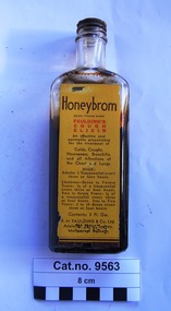 Coal Creek Community Park & Museum
Cough Mixture, 1906-1990 (ref. Trademark registration)
'Honeybrom' Trade mark 205, was first registered by F H Faulding in Australia ( Class 5: Chemical substances prepared for use in medicine and pharmacy), on 2 July 1906 and removed from the register on 2 July 1990. URL https://search.ipaustralia.gov.au/trademarks/search/view/205?q=honeybrom Rectangular clear glass bottle for screw top, but with only cork lining of top remaining, with a yellow label printed in dark brown and red, containing a dark brown viscous liquid.One base to one side 'A121' and on the other side '1960' or '19, symbol,0'. Paper label : 'Honeybrom REGD. TRADEMARK FAULDING'S COUGH ELIXIR An effective and agreeable preparation for the treatment of Colds, Coughs, Hoarseness, Bronchitis, and all Affections of the Chest and Lungs. DOSE: Adults : 1 teaspoonful every three or four hours. Children - Seven to Twelve Years : 1/2 of a teaspoonful every three or four hours. Two to Seven Years : 1/4 of a teaspoon every three or four hours. One to Two Years : 5 to 10 drops every three or four hours. Contents : 3 Fl. Ozs. F.H. Faulding & Co Ltd. Adelaide, Perth, Sydney, Melbourne, Brisbane'.bottle, moulded glass. -
 St Kilda Historical Society
Photograph - Photo map, 28/01/1951
One of a series of photo-maps produced for the Department of Crown Lands and Survey (1857-1983). For correlation with a current map, and access to other historical photo maps of Victoria, see the Historic Photo-Maps Index published by the Department of Environment, Land, Water and Planning at https://services.land.vic.gov.au/DELWPmaps/historical-photomaps/Black and white aerial photograph1424-45 SECRET 534 Run 18 Lens 12" Melbourne Metropolitan 12150 28.1.51 M639albert park, st kilda junction, st kilda pier, catani gardens, st kilda, prahran, albert park lake, 1951, middle park, st kilda beach, windsor -
 St Kilda Historical Society
Photograph - Photo map, 17/01/1951
One of a series of photo-maps produced for the Department of Crown Lands and Survey (1857-1983). For correlation with a current map, and access to other historical photo maps of Victoria, see the Historic Photo-Maps Index published by the Department of Environment, Land, Water and Planning at https://services.land.vic.gov.au/DELWPmaps/historical-photomaps/Black and white aerial photograph1414-21 538 Run 19 Lens 12" Melbourne Metropolitan 12150 17.1.51 M586st kilda, st kilda botanical gardens, peanut farm, elwood, 1951, point ormond, elwood canal, st kilda beach -
 St Kilda Historical Society
Photograph - Photo map, 28/01/1951
One of a series of photo-maps produced for the Department of Crown Lands and Survey (1857-1983). For correlation with a current map, and access to other historical photo maps of Victoria, see the Historic Photo-Maps Index published by the Department of Environment, Land, Water and Planning at https://services.land.vic.gov.au/DELWPmaps/historical-photomaps/Black and white aerial photograph1424-118 534 Run 20 Lens 12" Melbourne Metropolitan 12150 18.1.51M639elwood, point ormond, elwood park, elsternwick park, elwood beach, 1951 -
 St Kilda Historical Society
Photograph - Photo map, 17/01/1951
One of a series of photo-maps produced for the Department of Crown Lands and Survey (1857-1983). For correlation with a current map, and access to other historical photo maps of Victoria, see the Historic Photo-Maps Index published by the Department of Environment, Land, Water and Planning at https://services.land.vic.gov.au/DELWPmaps/historical-photomaps/Black and white aerial photograph1414-20 538 Run 19 Lens 12" Melbourne Metropolitan 12150 17.1.51 M586elwood, elsternwick, st kilda east, balaclava, ripponlea, 1951 -
 St Kilda Historical Society
Photograph - Photo map, 28/01/1951
One of a series of photo-maps produced for the Department of Crown Lands and Survey (1857-1983). For correlation with a current map, and access to other historical photo maps of Victoria, see the Historic Photo-Maps Index published by the Department of Environment, Land, Water and Planning at https://services.land.vic.gov.au/DELWPmaps/historical-photomaps/Black and white aerial photograph1424-44 534 Run 18 Lens 12" Melbourne Metropolitan 12150 28.1.51 M639 -
 St Kilda Historical Society
Photograph - Photo map, 28/01/1951
One of a series of photo-maps produced for the Department of Crown Lands and Survey (1857-1983). For correlation with a current map, and access to other historical photo maps of Victoria, see the Historic Photo-Maps Index published by the Department of Environment, Land, Water and Planning at https://services.land.vic.gov.au/DELWPmaps/historical-photomaps/Black and white aerial photograph1424-43 534 Run 18 Lens 12" Melbourne Metropolitan 12150 28.1.51 M639armadale, malvern, st kilda cemetery, caulfield north, st kilda east, 1951 -
 St Kilda Historical Society
Photograph - Photo map, 30/01/1960
One of a series of photo-maps produced for the Department of Crown Lands and Survey (1857-1983). For correlation with a current map, and access to other historical photo maps of Victoria, see the Historic Photo-Maps Index published by the Department of Environment, Land, Water and Planning at https://services.land.vic.gov.au/DELWPmaps/historical-photomaps/Black and white aerial photographVic 1093-62 Melbourne & Metropolitan Project Run 21 30.1.60 Lens 10" 8.200middle park, albert park, catani gardens, st kilda west, 1960 -
 St Kilda Historical Society
Photograph - Photo map, 30/01/1960
One of a series of photo-maps produced for the Department of Crown Lands and Survey (1857-1983). For correlation with a current map, and access to other historical photo maps of Victoria, see the Historic Photo-Maps Index published by the Department of Environment, Land, Water and Planning at https://services.land.vic.gov.au/DELWPmaps/historical-photomaps/Black and white aerial photographVic 1093-60 Melbourne & Metropolitan Project Run 21 30.1.60 Lens 10" 8.200st kilda, albert park, prahran, windsor, south yarra, 1960 -
 St Kilda Historical Society
Photograph - Photo map, 30/01/1960
One of a series of photo-maps produced for the Department of Crown Lands and Survey (1857-1983). For correlation with a current map, and access to other historical photo maps of Victoria, see the Historic Photo-Maps Index published by the Department of Environment, Land, Water and Planning at https://services.land.vic.gov.au/DELWPmaps/historical-photomaps/Black and white aerial photographVic 1092-36 Melbourne & Metropolitan Project Run 22 30.1.60 Lens 10" 8.200st kilda, st kilda pier, st kilda beach, catani gardens, 1960 -
 St Kilda Historical Society
Photograph - Photo map, 30/01/1960
One of a series of photo-maps produced for the Department of Crown Lands and Survey (1857-1983). For correlation with a current map, and access to other historical photo maps of Victoria, see the Historic Photo-Maps Index published by the Department of Environment, Land, Water and Planning at https://services.land.vic.gov.au/DELWPmaps/historical-photomaps/Black and white aerial photographVic 1092-38 Melbourne & Metropolitan Project Run 22 30.1.60 Lens 10" 8.200st kilda, st kilda beach, st kilda pier, catani gardens, 1960, st kilda botanical gardens, peanut farm -
 St Kilda Historical Society
Photograph - Photo map, 30/01/1960
One of a series of photo-maps produced for the Department of Crown Lands and Survey (1857-1983). For correlation with a current map, and access to other historical photo maps of Victoria, see the Historic Photo-Maps Index published by the Department of Environment, Land, Water and Planning at https://services.land.vic.gov.au/DELWPmaps/historical-photomaps/Black and white aerial photographVic 1092-40 Melbourne & Metropolitan Project Run 22 30.1.60 Lens 10" 8.200st kilda east, balaclava, ripponlea, st kilda cemetery, 1960 -
 St Kilda Historical Society
Photograph - Photo map, 30/01/1960
One of a series of photo-maps produced for the Department of Crown Lands and Survey (1857-1983). For correlation with a current map, and access to other historical photo maps of Victoria, see the Historic Photo-Maps Index published by the Department of Environment, Land, Water and Planning at https://services.land.vic.gov.au/DELWPmaps/historical-photomaps/Black and white aerial photographVic 1092-42 Melbourne & Metropolitan Project Run 22 30.1.60 Lens 10" 8.200malvern, caulfield, caulfield park, 1960 -
 St Kilda Historical Society
Photograph - Photo map, 30/01/1960
One of a series of photo-maps produced for the Department of Crown Lands and Survey (1857-1983). For correlation with a current map, and access to other historical photo maps of Victoria, see the Historic Photo-Maps Index published by the Department of Environment, Land, Water and Planning at https://services.land.vic.gov.au/DELWPmaps/historical-photomaps/Black and white aerial photographVic 1091-112 Melbourne & Metropolitan Project Run 23East 30.1.1960 Lens 10" 8.200elwood, point ormond, elwood park, elwood canal, 1960 -
 St Kilda Historical Society
Photograph - Photo map, 30/01/1960
One of a series of photo-maps produced for the Department of Crown Lands and Survey (1857-1983). For correlation with a current map, and access to other historical photo maps of Victoria, see the Historic Photo-Maps Index published by the Department of Environment, Land, Water and Planning at https://services.land.vic.gov.au/DELWPmaps/historical-photomaps/Black and white aerial photographVic 1091-110 Melbourne & Metropolitan Project Run 23East 30.1.60 Lens 10" 8.200elwood, elsternwick, elsternwick park, ripponlea, st kilda east, caulfield, balaclava, 1960 -
 St Kilda Historical Society
Photograph - Photo map, 30/01/1960
One of a series of photo-maps produced for the Department of Crown Lands and Survey (1857-1983). For correlation with a current map, and access to other historical photo maps of Victoria, see the Historic Photo-Maps Index published by the Department of Environment, Land, Water and Planning at https://services.land.vic.gov.au/DELWPmaps/historical-photomaps/Black and white aerial photographVic 1091-1 Melbourne & Metropolitan Project Run 24East 30.1.60 Lens 10" 8.200elwood, elwood beach, elwood park, 1960 -
 St Kilda Historical Society
Photograph - Photo map, 30/01/1960
One of a series of photo-maps produced for the Department of Crown Lands and Survey (1857-1983). For correlation with a current map, and access to other historical photo maps of Victoria, see the Historic Photo-Maps Index published by the Department of Environment, Land, Water and Planning at https://services.land.vic.gov.au/DELWPmaps/historical-photomaps/Black and white aerial photographVic 1091-2 Melbourne & Metropolitan Project Run 24East 30.1.60 Lens 10" 8.200elwood, elwood park, elwood beach, elsternwick park, 1960 -
 St Kilda Historical Society
Photograph - Photo map, 3/3/1964
One of a series of photo-maps produced for the Department of Crown Lands and Survey (1857-1983). For correlation with a current map, and access to other historical photo maps of Victoria, see the Historic Photo-Maps Index published by the Department of Environment, Land, Water and Planning at https://services.land.vic.gov.au/DELWPmaps/historical-photomaps/Black and white aerial photographVic 1833 Melbourne 1963 Project Run 15 3.3.64 Lens 205 152.70 M/M 5.150 56prahran, fawkner park, south yarra, albert park, 1964 -
 St Kilda Historical Society
Photograph - Photo map, 14/12/1963
One of a series of photo-maps produced for the Department of Crown Lands and Survey (1857-1983). For correlation with a current map, and access to other historical photo maps of Victoria, see the Historic Photo-Maps Index published by the Department of Environment, Land, Water and Planning at https://services.land.vic.gov.au/DELWPmaps/historical-photomaps/Black and white aerial photographVic 1807 Melbourne 1963 Project Run 16 14.12.63 Lens 205 152.70 M/M 5.150 179st kilda, prahran, albert park, st kilda east, balaclava, 1963 -
 St Kilda Historical Society
Photograph - Photo map, 14/12/1963
One of a series of photo-maps produced for the Department of Crown Lands and Survey (1857-1983). For correlation with a current map, and access to other historical photo maps of Victoria, see the Historic Photo-Maps Index published by the Department of Environment, Land, Water and Planning at https://services.land.vic.gov.au/DELWPmaps/historical-photomaps/Black and white aerial photographVic 1807 Melbourne 1963 Project Run 16 14.12.63 Lens 205 152.70 M/M 5.150 181st kilda cemetery, caulfield north, st kilda east, armadale, malvern, 1963 -
 St Kilda Historical Society
Photograph - Photo map, 14/12/1963
One of a series of photo-maps produced for the Department of Crown Lands and Survey (1857-1983). For correlation with a current map, and access to other historical photo maps of Victoria, see the Historic Photo-Maps Index published by the Department of Environment, Land, Water and Planning at https://services.land.vic.gov.au/DELWPmaps/historical-photomaps/Black and white aerial photographVic 1807 Melbourne 1963 Project Run 17 14.12.63 Lens 205 152,70 M/M 5.150 34st kilda, peanut farm, point ormond, st kilda marina, st kilda pier, 1963 -
 St Kilda Historical Society
Photograph - Photo map, 14/12/1963
One of a series of photo-maps produced for the Department of Crown Lands and Survey (1857-1983). For correlation with a current map, and access to other historical photo maps of Victoria, see the Historic Photo-Maps Index published by the Department of Environment, Land, Water and Planning at https://services.land.vic.gov.au/DELWPmaps/historical-photomaps/Black and white aerial photographVic 1806 Melbourne 1964 Project Run 18 14.12.63 Lens 205 152.70 M/M 5.150 161elsternwick, elsternwick park, elwood, elwood canal, elwood beach, elwood park, 1963 -
 St Kilda Historical Society
Photograph - Photo map, 12/04/1966
One of a series of photo-maps produced for the Department of Crown Lands and Survey (1857-1983). For correlation with a current map, and access to other historical photo maps of Victoria, see the Historic Photo-Maps Index published by the Department of Environment, Land, Water and Planning at https://services.land.vic.gov.au/DELWPmaps/historical-photomaps/Black and white aerial photographVic 1933 Melbourne 1966 Project Run 12 12.4.66 Lens 122 151.75MM 9.800 152st kilda, st kilda pier, st kilda marina, albert park, fawkner park, windsor, south yarra, prahran, st kilda west, middle park, st kilda beach, 1966 -
 St Kilda Historical Society
Photograph - Photo map, 12/04/1966
One of a series of photo-maps produced for the Department of Crown Lands and Survey (1857-1983). For correlation with a current map, and access to other historical photo maps of Victoria, see the Historic Photo-Maps Index published by the Department of Environment, Land, Water and Planning at https://services.land.vic.gov.au/DELWPmaps/historical-photomaps/Black and white aerial photographVic 1933 Melbourne 1966 Project Run 12 12.4.66 Lens 122 151.75MM 9.800 154st kilda, st kilda east, balaclava, toorak, amadale, caulfield, south yarra, st kilda botanical gardens, peanut farm, 1966 -
 St Kilda Historical Society
Photograph - Photo map, 12/04/1966
One of a series of photo-maps produced for the Department of Crown Lands and Survey (1857-1983). For correlation with a current map, and access to other historical photo maps of Victoria, see the Historic Photo-Maps Index published by the Department of Environment, Land, Water and Planning at https://services.land.vic.gov.au/DELWPmaps/historical-photomaps/Black and white aerial photographVic 1933 Melbourne 1966 Project Run 12 12.4.66 Lens 122 151.75MM 9.800 155 -
 St Kilda Historical Society
Photograph - Photo map, 08/02/1966
One of a series of photo-maps produced for the Department of Crown Lands and Survey (1857-1983). For correlation with a current map, and access to other historical photo maps of Victoria, see the Historic Photo-Maps Index published by the Department of Environment, Land, Water and Planning at https://services.land.vic.gov.au/DELWPmaps/historical-photomaps/Black and white aerial photographVic 1916 Melbourne 1966 Project Run 13 E 8.2.66 Lens 122 151.75MM 9.800 113st kilda, st kilda marina, st kilda beach, point ormond, elwood, elwood beach, elwood park, 1966 -
 St Kilda Historical Society
Photograph - Photo map, 08/02/1966
One of a series of photo-maps produced for the Department of Crown Lands and Survey (1857-1983). For correlation with a current map, and access to other historical photo maps of Victoria, see the Historic Photo-Maps Index published by the Department of Environment, Land, Water and Planning at https://services.land.vic.gov.au/DELWPmaps/historical-photomaps/Black and white aerial photographVic 1916 Melbourne 1966 Project Run 13 E 8.2.66 Lens 122 151.75MM 9.800 111st kilda, balaclava, caulfield, caulfield north, st kilda east, elsternwick, elsterwick park, elwood park, elwood canal, elwood beach, ripponlea, 1966 -
 St Kilda Historical Society
Photograph - Photo map, 11/01/1968
One of a series of photo-maps produced for the Department of Crown Lands and Survey (1857-1983). For correlation with a current map, and access to other historical photo maps of Victoria, see the Historic Photo-Maps Index published by the Department of Environment, Land, Water and Planning at https://services.land.vic.gov.au/DELWPmaps/historical-photomaps/Black and white aerial photographVic 2132 State Aerial Survey Melbourne 1968 Proj Run 27E 11.1.68 5100 ASL 65caulfield north, caulfield park, armadale, malvern, 1968 -
 St Kilda Historical Society
Photograph - Photo map, 11/01/1968
One of a series of photo-maps produced for the Department of Crown Lands and Survey (1857-1983). For correlation with a current map, and access to other historical photo maps of Victoria, see the Historic Photo-Maps Index published by the Department of Environment, Land, Water and Planning at https://services.land.vic.gov.au/DELWPmaps/historical-photomaps/Black and white aerial photographVic 2132 State Aerial Survey Melbourne 1968 Proj Run 27E 11.1.68 5100 ASL 67st kilda east, st kilda cemetery, caulfield north, alma park, balaclava, armadale, 1968