Showing 23235 items matching "smythes-creek"
-
 Bendigo Historical Society Inc.
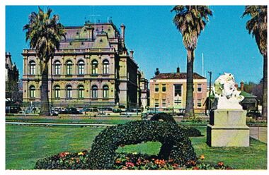
Postcard - LAW COURTS, BENDIGO
Postcard: image shows Law Courts, Bendigo. Former Police Station on RH side of Law Courts, beside Police Station is a Victorian house, bordering the Bendigo Creek and entry into Rosalind Park. In foreground, ivy basket, statue in Conservatory Gardens.Plastichromebendigo, buildings, law courts, bendigo, law courts, police station -
 Bendigo Historical Society Inc.
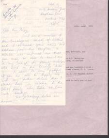
Document - LETTER: DALEY FAMIILY (EMU CREEK, BENDIGO), 13th February, 1975
Letter re Daley family (Emu creek, Bendigo) 13/2/1975 from E Murray to BHS. Supplied details of family post 1853 - details of number of children and names etc. Request for further information - no substantial answer to request..person, individual, daley family -
 Bendigo Historical Society Inc.
Map - SALISBURY : COUNTY OF BENDIGO, 1965
Map. Salisbury, County of Bendigo, Pompapiel, Yallook, Yarraberb, Yarrayne, Bullock Creek. Drawn and reproduced at the Department of Lands and Survey, Melbourne. Price $1.00. 1965. By authority A.C. Brooks, Government Printer, Melbourne. (number 28 in map cupboard 1)A.C. Brooks,Government Printer, Melbourne.map, bendigo, salisbury -
Bendigo Historical Society Inc.
Map - WARRAGAMBA : COUNTY OF BENDIGO, 29-4-30
Map. Warragamba, County of Bendigo, Pannoomilloo, Kamarooka, Minto, Diggorra. By authority H.J. Green, Government Printer. Piccaninny Creek. Drawn and reproduced at the Deparment of Lands and Survey, Melbourne. 29-3-30. Price2/-. (number 10 in map cupboard 1)H.J. Green, Government Printermap, bendigo, warragamba -
Bendigo Historical Society Inc.
Map - SALISBURY : COUNTY OF BENDIGO, 1965
Map. Salisbury, County of Bendigo, Pompapiel, Yarrayne, Yarraberb, Yallook, Bullock Creek. By Authority: A.C. Brooks, Government Printer, Melbourne. Drawn and reproduced at the Department of Lands and Survey, Melbourne.1965. Price $1.00. (number 6 in map cupboard 1)A.C. Brooks, Government Printermap, bendigo, salisbury -
 Stratford and District Historical Society
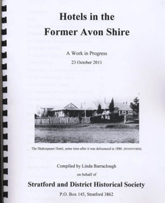
Book, Barraclough, Linda, Hotels in the former Avon Shire: A Work in Progress, 2011
Published book (processed, comb bound) "Hotels in the former Avon Shire: A Work in Progress". 47 pages, illus., A4, Edition May 2012. Includes hotels at Stratford, Nuntin, Delvine, Munro, Stockdale, Cobbanah, Dargo, Grant, Iguana Creek. -
 Tatura Irrigation & Wartime Camps Museum
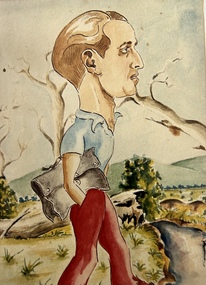
Photograph - Photograph of Painting, Self Portrait George Rosenkranz, 1945
Colour photograph of a self portrait of George Rosenkranz, Graytown camp 1945. Brown hair, blue shirt, red trousers, hand in pocket. Holding a grey satchel bag. Rolling hills in background. Trees, plants and creek right hand bottom.internees, george rosenkranz, graytown victoria -
 Hume City Civic Collection
Photograph, c 1980s
The stone bridge was the only entry into Sunbury on the eastern side of the town and was in use until the road was re-routed and widened in the 1970s.A coloured photograph of the roadway over the Macedon Street bridge which spans Jacksons Creek. There is a grassy area in the foreground with trees growing either side of the bridge. The narrow asphalted surface of the road across the bridge is cut off by a low stone wall.stone bridges, jacksons creek, macedon street road bridge, george evans collection -
 Hume City Civic Collection
Photograph, early 1980s
The photograph shows the extent of Sunbury's development to the west of the town in the early 1980s. The settlement at this stage extended along either side of Gap Road for about 0.5 km beyond Elizabeth Drive.A coloured landscape photograph with rounded corners taken from Mt. Holden and looking towards the expanding town of Sunbury. The Melba Avenue drain which flows into Blind Creek is in the foreground. Sheoak Hill, the site of the former Sunbury Asylum is in the middle of the skyline.sunbury township, reservoir road, mt. holden, sunbury asylum, george evans collection -
 Sunshine and District Historical Society Incorporated
Map (1967), CITY OF SUNSHINE, June 1967, 1967
The City of Sunshine no longer exists. Part of the eastern area has been annexed by the City of Maribyrnong, and the rest of the old City of Sunshine has been amalgamated with the City of Keilor to form the larger City of Brimbank.This 1967 map is a historical record of the City of Sunshine as it existed 27 years before the amalgamation of Councils, and the creation of the City of Brimbank in 1994.Whitish paper map with black printing that is laminated in clear plastic film, and has a wood slat attached to the top edge. The June 1967 map is of the previous CITY OF SUNSHINE showing City and Parish boundaries, streets, railways, creeks, river etc.Purple ink stamps at top left hand and right hand areas showing address and contact details of 'Sunshine Industrial Promotion Centre.'city of sunshine, june 1967, map, city, parish, boundaries, brimbank -
Stawell Historical Society Inc
Accessory - Jewellery
1930's Collection of seven items of costume dress jewelry belonging to Mary and Margaret Devery of Greens Creek Two bracelets, two clips for Dresses or Shoes,. Jewelry Accessory (part), Hair Coombe and Flower Broach in two cardboard boxes.clothing -
Whitehorse Historical Society Inc.
Map, Dandenong Ranges area. Sheet 7, c1957
Detailed map covering area from Mitcham and Vermont to Ringwood and Heathmont.Detailed map covering area from Mitcham and Vermont to Ringwood and Heathmont. Shows streets, block boundaries, buildings, railway and creeks. Note says prepared from State Aerial Survey, April 1954 and Cadastrial Survey information July 1956.Detailed map covering area from Mitcham and Vermont to Ringwood and Heathmont. maps, mitcham, vermont, ringwood, heathmont -
 Southern Sherbrooke Historical Society Inc.
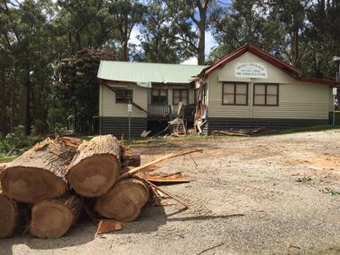
Photograph - Menzies Creek Hall damaged by storm, 2016
Colour photographs of Menzies Creek Hall damaged by a falling tree during a wind storm, 10th October 2016. In the first photo several cut logs in the foreground. The second photo shows a room bisected by the tree. Photos taken by Marian Matta. -
 Southern Sherbrooke Historical Society Inc.
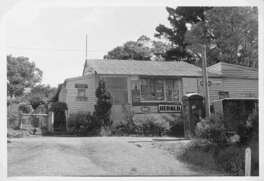
Photograph - Menzies Creek Post Office, 1968
Photograph of Menzies Creek Post Office and General Store on the Belgrave-Gembrook Rd. Shows narrow flight of stairs to doorway. In front of store is a telephone box and a bus shelter, Many trees visible in background. Photo from National Archives of Australia. -
 Southern Sherbrooke Historical Society Inc.
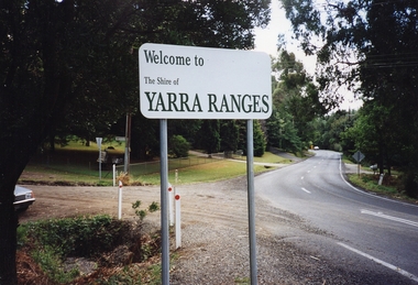
Photograph - Photo, temporary shire sign. Shire of Yarra Ranges
Colour photograph of entrance to Menzies Creek looking west, showing the new temporary Shire sign after amalgamation of Victoria's council areas in 1995. Belgrave-Gembrook Rd with Menzies Rd going to the left. Photo taken in 1995 by Marian Matta. -
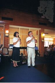 Bendigo Historical Society Inc.
Photograph - PETER ELLIS COLLECTION: EMU CREEK BUSH BAND, 25th November, 2007
Colour photograph. Emu Creek Bush Band playing in hall. Blue carpet. Marg Hogan and Peter Ellis playing recorder. Back of photo reads: Bendigo Retirement Village Sunday Nov. 25th 2007 Margaret Hogan Peter Ellis.entertainment, music, emu creek bush band -
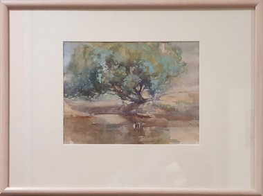 Federation University Art Collection
Painting - Watercolour, McGeorge, Norman, Untitled, c mid 1940s
Norman MacGEORGE (08 July 1872– 2 September 1952) Born Adelaide, South Australia Norman Macgeorge taught drawing at Wesley College, Melbourne from 1902-06. He also taught at Melbourne Teachers' College and at Melbourne Church of England Grammar School. This item is part of the Federation University Art Collection. The Art Collection features over 2000 works and was listed as a 'Ballarat Treasure' in 2007.Framed landscape depicting the confluence of the Darebin Creek and the Yarra River. Purchased by the Ballarat Teachers' College in 1964. This work was exhibited in "Norman MacGeorge: Man of Art" at the Ian Potter Museum of Art, The University of Melbourne, 22 September to 25 November 2001.art, artwork, norman mcgeorge, mcgeorge, watercolour, available, landscape, darebin creek, yarra river, ballarat teachers' college art collection -
Tarnagulla History Archive
Compilation file: The Dunolly, Tarnagulla and St Arnaud Express and The Dunolly & Burnt Creek Express - Tarnagulla references, 1860 on and 1862 - 1863
David Gordon Collection. A black plastic folio containing many pages of photocopies from Dunolly, Tarnagulla and St Arnaud Express newspaper (1863 - ) and The Dunolly & Burnt Creek Express newspaper (May 1862 - August 1863) - all which reference Tarnagulla in some way. newspapers -
Tarnagulla History Archive
Article - News article: John Heather on Penny Farthing, c. 1960s
Williams Family Collection. Small news clipping with title 'The Cover'. Discusses John Heather riding a Penny Farthing on his Murphy's Creek farm. Also that the bike previously belonged to Herman Bock, who purportedly rode it from Tarnagulla to Bendigo before there were roads. tarnagulla -
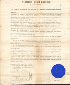 Bendigo Historical Society Inc.
Document - BROCKLEY FAMILY DOCUMENTS: PERMIT TO DIG AND MAKE A GRAVE
Certificate from the Sandhurst Public Cemetery Back Creek for Robert Brockley of Bendigo to dig and make a grave according to the conditions. Dated 15th May 1891 and signed by Members of the Council and the Town Clerk. Has a blue seal in the bottom left corner.document, certificate, personal, sandhurst public cemetery back creek, robert brckley, j h abbott -
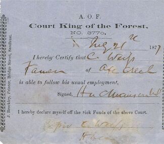 Bendigo Historical Society Inc.
Document - ANCIENT ORDER OF FORESTERS NO 3770 COLLECTION: DOCTOR'S CERTIFICATE
Blue Doctor's Certificate dated Aug 21st, 1877, certifying that Christian Weip of Axe Creek was able to follow his usual employment. Signed by H. L. Atkinson. Signed at the end by Christian Weip declaring himself off the Sick Funds.societies, aof, correspondence, ancient order of foresters no 3770 collection - doctor's certificate, court king of the forest, christian weip, h l atkinson, j brockley -
 Eltham District Historical Society Inc
Album - Photograph, J.A. McDonald, Eltham-Yarra Glen Road, 26 Jan. 1956
Watsons Creek Showing steel work 26/1/1956Record of various Shire of Eltham infrastructure works undertaken during the period of 1952-1962 involving bridge and road reconstruction projects, sometimes with Eltham Shire Council Project Reference numbers quoted. It was during this period that a number of significant improvements were made to roads and new bridges constructed within the shire that remain in place as of present day (2022). In many situations, the photos provide a tangible visible record of infrastructure that existed throughout the early days of the Shire. The album was put together by or under the direction of the Shire Engineer, J.A. McDonald.infrastructure, road construction, shire of eltham, bridge construction, eltham-yarra glen road, w.e. wolf, watsons creek, 1956-01-26 -
 Eltham District Historical Society Inc
Album - Photograph, J.A. McDonald, Old Healesville Road, Sep. 1958
Paul Creek Road September 1958 Showing west abutmentRecord of various Shire of Eltham infrastructure works undertaken during the period of 1952-1962 involving bridge and road reconstruction projects, sometimes with Eltham Shire Council Project Reference numbers quoted. It was during this period that a number of significant improvements were made to roads and new bridges constructed within the shire that remain in place as of present day (2022). In many situations, the photos provide a tangible visible record of infrastructure that existed throughout the early days of the Shire. The album was put together by or under the direction of the Shire Engineer, J.A. McDonald.infrastructure, shire of eltham, bridge construction, road construction, old healesville road, paul creek road, 1958-09 -
 Eltham District Historical Society Inc
Album - Photograph, J.A. McDonald, Yarra Glen-Glenburn Road, Nov. 1956
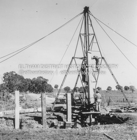
Cylinder foundation – Jehosophat Creek Showing flume – March 1956Record of various Shire of Eltham infrastructure works undertaken during the period of 1952-1962 involving bridge and road reconstruction projects, sometimes with Eltham Shire Council Project Reference numbers quoted. It was during this period that a number of significant improvements were made to roads and new bridges constructed within the shire that remain in place as of present day (2022). In many situations, the photos provide a tangible visible record of infrastructure that existed throughout the early days of the Shire. The album was put together by or under the direction of the Shire Engineer, J.A. McDonald.infrastructure, shire of eltham, 1956-03, bridge construction, jehosophat creek, road construction, yarra glen-glenburn road -
 Eltham District Historical Society Inc
Album - Photograph, J.A. McDonald, Yarra Glen-Glenburn Road, May 1957
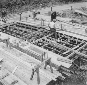
Jehosophat Creek – 56M295 May 1957 Preparation for Deck pourRecord of various Shire of Eltham infrastructure works undertaken during the period of 1952-1962 involving bridge and road reconstruction projects, sometimes with Eltham Shire Council Project Reference numbers quoted. It was during this period that a number of significant improvements were made to roads and new bridges constructed within the shire that remain in place as of present day (2022). In many situations, the photos provide a tangible visible record of infrastructure that existed throughout the early days of the Shire. The album was put together by or under the direction of the Shire Engineer, J.A. McDonald.infrastructure, shire of eltham, bridge construction, jehosophat creek, road construction, yarra glen-glenburn road, 1957-05 -
 Eltham District Historical Society Inc
Album - Photograph, J.A. McDonald, Yarra Glen-Glenburn Road, June 1957
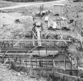
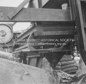
Jehosophat Creek – 56M295 June 1957 Weigh batcher in operationRecord of various Shire of Eltham infrastructure works undertaken during the period of 1952-1962 involving bridge and road reconstruction projects, sometimes with Eltham Shire Council Project Reference numbers quoted. It was during this period that a number of significant improvements were made to roads and new bridges constructed within the shire that remain in place as of present day (2022). In many situations, the photos provide a tangible visible record of infrastructure that existed throughout the early days of the Shire. The album was put together by or under the direction of the Shire Engineer, J.A. McDonald.infrastructure, shire of eltham, bridge construction, jehosophat creek, road construction, yarra glen-glenburn road, 1957-06 -
 Eltham District Historical Society Inc
Album - Photograph, J.A. McDonald, Yarra Glen-Glenburn Road, June 1957
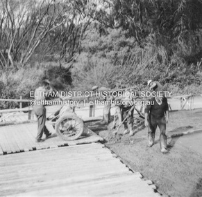
Jehosophat Creek – 56M295 June 1957 Placing deck concreteRecord of various Shire of Eltham infrastructure works undertaken during the period of 1952-1962 involving bridge and road reconstruction projects, sometimes with Eltham Shire Council Project Reference numbers quoted. It was during this period that a number of significant improvements were made to roads and new bridges constructed within the shire that remain in place as of present day (2022). In many situations, the photos provide a tangible visible record of infrastructure that existed throughout the early days of the Shire. The album was put together by or under the direction of the Shire Engineer, J.A. McDonald.infrastructure, shire of eltham, bridge construction, jehosophat creek, road construction, yarra glen-glenburn road, 1957-06 -
 Eltham District Historical Society Inc
Negative - Photograph, J.A. McDonald, Healesville-Yarra Glen Road, c.May 1958
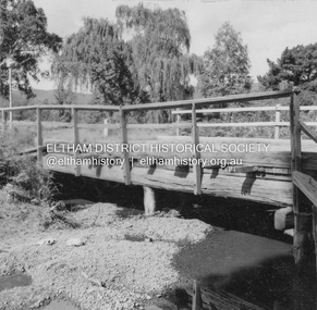
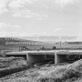
‘U’ slabs Paul Creek bridge, Tarrawarra Contractor WolfRecord of various Shire of Eltham infrastructure works undertaken during the period of 1952-1962 involving bridge and road reconstruction projects, sometimes with Eltham Shire Council Project Reference numbers quoted. It was during this period that a number of significant improvements were made to roads and new bridges constructed within the shire that remain in place as of present day (2022). In many situations, the photos provide a tangible visible record of infrastructure that existed throughout the early days of the Shire. The album was put together by or under the direction of the Shire Engineer, J.A. McDonald.infrastructure, shire of eltham, bridge construction, 1958-05, healesville-yarra glen road, paul creek bridge, w.e. wolf, tarrawarra -
 Halls Gap & Grampians Historical Society
Photograph - Coloured
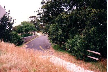
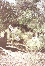
An old bridge at Back Creek on the Heatherlie Quarry Rail line.Photo shows the beginning of a bridge that has become dilapidated with time. Large beams lie around covered in weeds. Bushy growth has grown over the bridge.structures, bridges -
 Eltham District Historical Society Inc
Photograph, 41 Antoinette Boulevard, cnr of Main Road, Eltham, c.May 2001
East side of Main Road near Diamond Creek BridgeRoll of 35mm colour negative film, 7 stripsAgfa HDC 200 plus-2eltham, streets, main road, antoinette boulevard