Showing 11439 items
matching maps
-
 Bendigo Historical Society Inc.
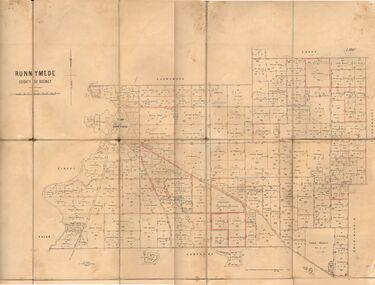
Map - JACK FLYNN COLLECTION: RUNNYMEDE, June 1946
Map: Parish of Runnymede, County of Rodney. Parish plan.By Authority: J.J. Goourley, Government Printer, Melbourne. Drawn and Reproduced at the Lands and Servey, Melbourne, Victoria. June, 1946.map, rodney, parish plan, runnymede -
 Bendigo Historical Society Inc.
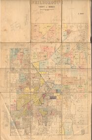
Map - JACK FLYNN COLLECTION: NEILBOROUGH, 13/10/1927
Map: Parish of Neilborough, County of Bendigo. Parish plan.Photo Lithographed at the Department of Lands and Survey, Melbourne by W.J. Butsonmap, bendigo, parish plan, neilborough -
 Bendigo Historical Society Inc.
Map - JACK FLYNN COLLECTION: MUSKERRY, 1962
Map: Parish of Muskerry, County of Rodney. Parish plan.By Authority: A.C. Brooks, Government Printer, Melbourne. Drawn and reproduced at the Department of Lands and Survey, Melbournemap, rodney, parish plan, muskerry -
 Bendigo Historical Society Inc.
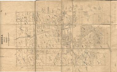
Map - JACK FLYNN COLLECTION: MOORA, 9/10/22
Map: Parish of Moora, County of Rodney. Parish plan.By Authority A.J. Mullet Government Printer Melbourne. Photo Lithographed at the Dept, of Lands and Survey, Melbourne by W.J. Butson. 3.10.22map, rodney, parish plan, moora -
 Bendigo Historical Society Inc.
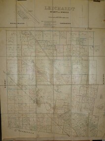
Map - JACK FLYNN COLLECTION: LEICHARDT, 14/03/1`939
Map: Parish of Leichardt, County of Bendigo. Parish plan.Drawn and Reproduced at the Dept, of Lands and Survey, Melbourne, Victoria. 14.3.1939map, bendigo, parish plan, leichardt -
 Bendigo Historical Society Inc.
Map - JACK FLYNN COLLECTION: HAYANMI, March 1953
Map: Parish of Hayanmi, County of Bendigo. Parish plan.By Authority: W.M. Houston, Government Printer. Drawn and reproduced at the Dept, of Lands and Survey, Melbourne, Victoriamap, bendigo, parish plan, hayanmi -
 Bendigo Historical Society Inc.
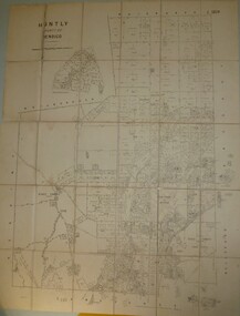
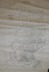
Map - JACK FLYNN COLLECTION: HUNTLY, 8/09/1921
Map: Parish of Huntly, County of Bendigo. Parish plan.By Authority, Govt., Printer. A. J. Mullett. Photo Lithographed at the Department of Land and Survey Melbourne By W. J. Butsonmap, bendigo, parish plan, huntly -
 Bendigo Historical Society Inc.
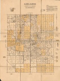
Map - JACK FLYNN COLLECTION: GIRGARRE, 14/10/1943
Map: Parish of Girgarre. County of Rodney. Parish plan.By Authority, H.E. Daw, Government Printer Melbourne. Drawn and produced at the Dept of Lands and Survey, Melbourne, Victoria. 14.10.1943map, rodney, parish plan, girgarre, county of rodney -
 Bendigo Historical Society Inc.
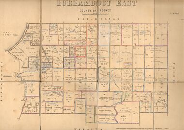
Map - JACK FLYNN COLLECTION: BURRUMBOOT EAST, 21/12/1027
Map: Burrumboot East, County of Rodney. Parish plan.Photo Lithographed at the Department of Lands and Survey, Melbourne by W.J.Butson. 21.12.27map, rodney, parish plan, burrumboot east -
 Bendigo Historical Society Inc.
Map - JACK FLYNN COLLECTION: ECHUCA NORTH, November 1953
Map: Echuca North, County of Rodney. Parish plan.By Authority: W.M. Houston, Government Printer. Drawn and Reproduced at the Dept., of Lands and Survey Melbourne, Victoria. November 1953map, rodney, parish plan, echuca north rodney -
 Bendigo Historical Society Inc.
Map - JACK FLYNN COLLECTION: BURNEWANG, 17/09/1918
Map: Parish of Burnewang, County of Rodney. Parish plan.By Authority, H. J. Green, Acting Government Printer Melbourne. Photo Lithographed at the Department of Lands and Survey, Melbourne by W. J. Butson.map, rodney, parish plan, burnewang, rodney -
 Bendigo Historical Society Inc.
Map - JACK FLYNN COLLECTION: BONN, 16/07/1919
Map: Parish of Bonn, County of Rodney. Parish plan.By Authority A. J. Mullett. Government Printer, Melbourne. Photo Lithographed at the Department of Lands and Survey. Melbourne by W. J. Butson.map, rodney, parish plan, bonn, rodney -
 Bendigo Historical Society Inc.
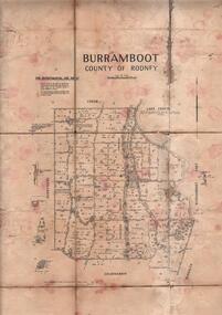
Map - JACK FLYNN COLLECTION: BURRUMBOOT, August 1951
Map: Parish of Burrumboot, County of Rodney. Parish plan.By Authority J.J. Gourley, Government Printer Melbourne. Drawn and Reproduced at the Dept of Lands and Survey, Melbourne, Victoria. August 1951map, rodney, parish plan, burrumboot, rodney -
 Bendigo Historical Society Inc.
Map - JACK FLYNN COLLECTION: BEALIBA, 15/09/1931
Map: Parish of Bealiba, County of Gladstone. Parish plan.By Authority H.J. Green, Government Printer. Photo Lithographed at the Government of Lands and Survey Melbourne. 15.9.31map, gladstone, parish plan, bealiba, gladstone -
 Bendigo Historical Society Inc.
Map - JACK FLYNN COLLECTION: BAMAWM, 19/08/1924
Map: Parish of Bamawm, County of Bendigo. Parish plan.Photo Lithographed at the Department of Lands and Survey, Melbourne by W.J. Butson. 19.8.24map, bendigo, parish plan, bamawm -
 Bendigo Historical Society Inc.
Map - JACK FLYNN COLLECTION: HUNTLY, August 1954
Map: Parish of Huntly, County of Bendigo. Parish plan.By Authority W.M. Houston, Government Printer. Drawn and Reproduced at the Dept, of Lands and Survey, Melbourne, Victoria. August 1954.map, bendigo, parish plan, huntly -
 Bendigo Historical Society Inc.
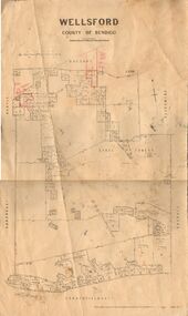
Map - JACK FLYNN COLLECTION: WELLSFORD, 2/11/1914
Map: Parish of Wellsford, County of Bendigo. Parish plan.Photo-Lithographed at the Department of Lands and Survey Melbourne By H.J. Butson. 2-.11.14map, bendigo, parish plan, wellsford -
 Bendigo Historical Society Inc.
Map - JACK FLYNN COLLECTION: YARRAYNE, 6/01/1932
Map: Parish of Yarrayne, County of Bendigo. Parish plan.By Authority, H.J. Green, Govt., Printer. Photo-Lithographed at the Department of Lands and Survey, Melbourne. 5.1.32.map, bendigo, parish plan, yarrayne -
 Bendigo Historical Society Inc.
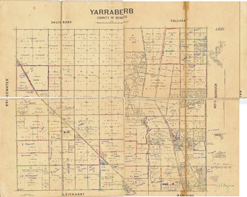
Map - JACK FLYNN COLLECTION: YARRABERB, NO date visible
Map: Parish of Yarraberb, County of Bendigo. Parish plan.By Authority H.J. Green. Govt., Printer.map, bendigo, parish plan, yarraberb -
 Bendigo Historical Society Inc.
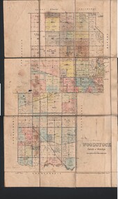
Map - JACK FLYNN COLLECTION: WOODSTOCK, 27/03/75
Map: Parish of Woodstock , County of Bendigo. Parish plan.Photo-Lithographed at the Department of Lands and Survey Melbourne by J. Noone. 27.3.79map, bendigo, parish plan, woodstock -
 Bendigo Historical Society Inc.
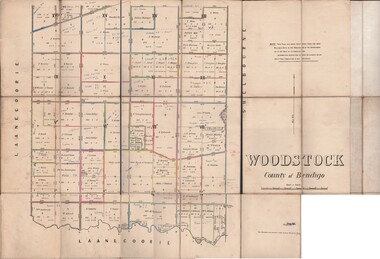
Map - JACK FLYNN COLLECTION: WOODSTOCK, 4/07/1935
Map: Parish of Woodstock, County of Bendigo. Parish plan.By Authority H.J. Green. Govt Printer. Drawn and Reproduced at the Dept of Lands and Survey, Melbourne Victoria. 4.7.35map, bendigo, parish plan, woodstock -
 Bendigo Historical Society Inc.
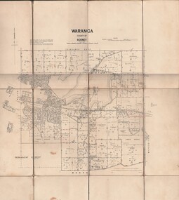
Map - JACK FLYNN COLLECTION: WARANGA, 1959
Map: Parish of Waranga, County of Rodney. Parish plan.By Authority. A.C. Brooks. Government Printer Melbourne. Drawn and Reproduced at the Department of lands and survey. Melbourne 1959.map, rodney, parish plan, waranga -
 Bendigo Historical Society Inc.
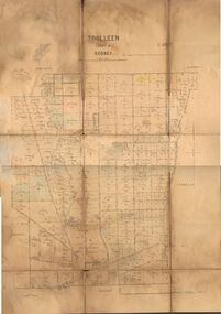
Map - JACK FLYNN COLLECTION: TOOLLEEN, 25/05.1926
Map: Parish of Toolleen, County of Rodney. Parish plan.By Authority, H.J. Green. Govt., Printer. Photo-Lithographed at the Department of Lands and Survey Melbourne. W. J. Butson 25.5.26.map, rodney, parish plan, toolleen -
 NMIT (Northern Melbourne Institute of TAFE)
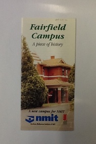
Brochure - NMIT Fairfield campus, Fairfield Campus: a piece of history, 2001
This brochure contains information on the 'new' NMIT campus at Fairfield, opened in 2001. It includes details of proposed courses and information about how to reach the campus.Tri-fold brochure with text, colour illustrations and map. fairfield, fairfield campus, nmit, -
 Bendigo Historical Society Inc.
Map - CITY OF SANDHURST SHEET NO.6, 25/04/1882
Map: City of Sandhurst sheet No. 6. Parish planmap, bendigo, parish plan, sandhurst -
Bendigo Historical Society Inc.
Map - SANDHURST, Circa 1906
Map: Parish of Sandhurst, County of Bendigo. Parish planmap, bendigo, parish plan, sandhurst -
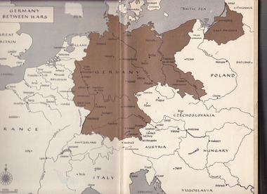 Monbulk RSL Sub Branch
Book, Doubleday and Company Inc, Adolf Hitler, 1976
A biography of Adolf Hitler, based in part on more than one hundred and fifty interviews with people directly involved with his life. This comprehensive biography of Adolf Hitler is based in part on more than one hundred and fifty interviews with people directly involved in his life.Index, bib, notes, ill, maps, p.1035.non-fictionA biography of Adolf Hitler, based in part on more than one hundred and fifty interviews with people directly involved with his life. This comprehensive biography of Adolf Hitler is based in part on more than one hundred and fifty interviews with people directly involved in his life. adolf hitler - military leadership, adolf hitler - 1889-1945 - biography -
Moorabbin Air Museum
Map (item) - Aloha Airlines - map of the islands of Hawaii, Aloha Airlines - map of the islands of Hawaii circa 1955
-
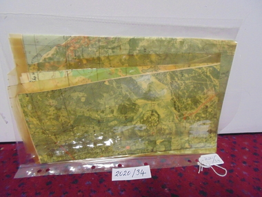 National Vietnam Veterans Museum (NVVM)
Map
A laminated coloured map around the South China Seamap, 3rar, mcphail collection -
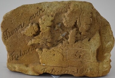 Tatura Irrigation & Wartime Camps Museum
Plaque, 1940
Made by internee at Camp 1 TaturaHandcarved plaque featuring map of Europe and words in Germancarving, camp 1, tatura, europe