Showing 3907 items matching "bricker"
-
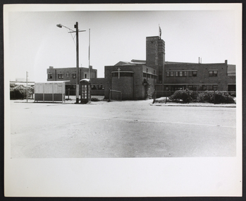
 Mission to Seafarers Victoria
Photograph - Photograph, Black and white, Bill Doyle (Reverend C.J. Eldridge-Doyle), 1948-1954
Small b & w photograph depicting 1930's Mission to Seafarers building at Port Melbournemission, port melbourne, art deco, harry a. norris, alfred m. nicholas, brick, beach street, huntingfield hall, king george v memorial building, seamen mission, mission to seamen, mission to seafarers, 1937, phone booth, phone box, bill doyle -
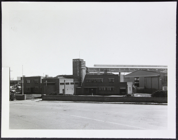
 Mission to Seafarers Victoria
Photograph - Photograph, Black and white, Bill Doyle (Reverend C.J. Eldridge-Doyle), 1948-1954
large b & w photograph street view of the Art Deco Mission in Port Melbourneart deco, mission, harry a. norris, alfred m. nicholas, brick, king george v memorial building, beach street, port melbourne, 1937, seamen mission, mission to seamen, mission to seafarers, phone booth, bus stop, bill doyle -
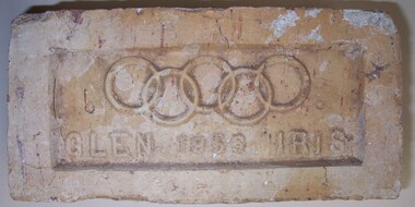 Glenelg Shire Council Cultural Collection
Geological specimen - Brick - Glen Iris 1956 Olympics Brick, n.d
Displayed at History HouseUnknown -
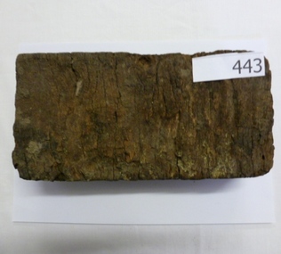 Greensborough Historical Society
Brick, Wooden road block, 1880s
Accompanied by article by Kevin Patterson (Nillumbik Historical Society) which explains the use of these blocks as a road surface in the City of Melbourne from the 1880s. The final wood blocks were dismantled in the 1950s and blocks sent to suburban wood yards to be sold as fuel for open fires and combustion heaters.As most of these blocks were sold for fuel, it is unusual to find one surviving. Block of timber cut to size and dipped in tar for use a a road block. wood blocks, paving, melbourne, road surfaces, tar -
 Eltham District Historical Society Inc
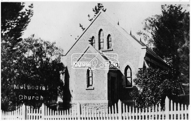
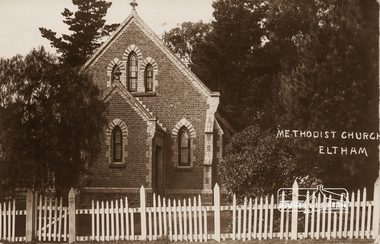
Photograph, Eltham - Methodist Church (1880)
RERVISED STATEMENT OF SIGNIFICANCE, CONTEXT, 2010 What is significant? The 1880 bichromatic brick church and the surrounding site to the title boundaries. How is it significant? The church is architecturally, historically, socially and spiritually significant to the Shire of Nillumbik. Why is it significant? The church is architecturally significant as a finely detailed example of a brick 19th century rural community church, one of only four in the Shire (Criteria E & B). The church is historically significant as an important link with the time when Eltham was a small, insular country settlement. Also for the historical evolution visible in the complex, with the modest 1880s church and larger red brick rear hall from the early 20th century as a reflection of population growth in the area (Criterion A). The church is historically, spiritually and socially significant because it has played, and continues to play, an important part in the spiritual and social life of the community (Criterion G) - Victorian Heritage Register. This photo forms part of a collection of photographs gathered by the Shire of Eltham for their centenary project book,"Pioneers and Painters: 100 years of the Shire of Eltham" by Alan Marshall (1971). The collection of over 500 images is held in partnership between Eltham District Historical Society and Yarra Plenty Regional Library (Eltham Library) and is now formally known as the 'The Shire of Eltham Pioneers Photograph Collection.' It is significant in being the first community sourced collection representing the places and people of the Shire's first one hundred years.Digital image"Methodist Church"sepp, shire of eltham pioneers photograph collection, eltham, methodist church -
 Eltham District Historical Society Inc
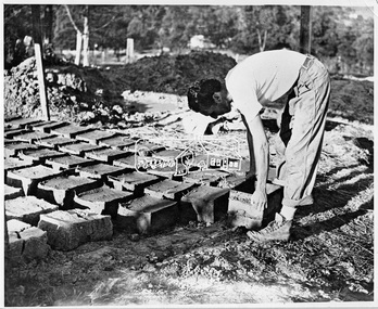
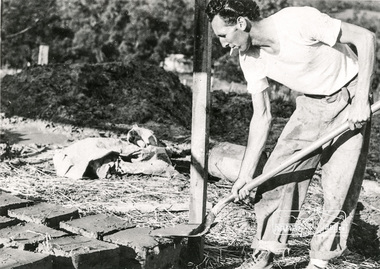
Photograph, Eltham - Making mud bricks, c.1970
Similar picture EDHS_00739 reproduced on page 110 "Pioneers & Painters"This photo forms part of a collection of photographs gathered by the Shire of Eltham for their centenary project book,"Pioneers and Painters: 100 years of the Shire of Eltham" by Alan Marshall (1971). The collection of over 500 images is held in partnership between Eltham District Historical Society and Yarra Plenty Regional Library (Eltham Library) and is now formally known as the 'The Shire of Eltham Pioneers Photograph Collection.' It is significant in being the first community sourced collection representing the places and people of the Shire's first one hundred years.Digital image, 20 x 25 cm B&W print and 4 x 5 inch B&W Negsepp, shire of eltham pioneers photograph collection, eltham, mud bricks, tony jackson -
 Eltham District Historical Society Inc
Photograph, Marjorie North, Mud brick house, Napier Crescent, Montmorency, 16 Dec 1985, 1986
Negatives supplied by Marjorie North 1 July 1986 for Montmorency France albumRoll of 35mm colour negative film, 4 of 6 stripsKodak CP 100 5094montmorency, mudbrick, houses, napier crescent -
 Eltham District Historical Society Inc
Photograph, Marjorie North, Mud brick house, Napier Crescent, Montmorency, Dec 1985, 1986
Negatives supplied by Marjorie North 1 July 1986 for Montmorency France albumRoll of 35mm colour negative film, 4 of 6 stripsKodak CP 100 5094montmorency, mudbrick, houses, napier crescent -
 Eltham District Historical Society Inc
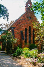
Photograph, St Margaret's Church, Eltham, 2012
Digital scan of photograph - Original Source Copy: St Margaret's Parish Archives. church of england, churches, eltham, st margarets church, mud bricks, robert marshall -
 Eltham District Historical Society Inc
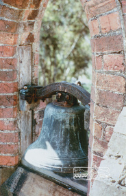
Photograph, 1861 Bell and Bell Tower, St Margaret's Anglican Church, Eltham
Digital scan of photograph - Original Source Copy: St Margaret's Parish Archives. church of england, churches, eltham, st margarets church, mud bricks, robert marshall -
 Eltham District Historical Society Inc
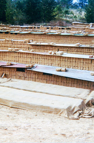
Photograph, Making the mudbricks for St Margaret's Anglican Church Hall, Eltham, 1978
Digital scan of photograph - Original Source Copy: St Margaret's Parish Archives. church of england, churches, eltham, st margarets church, mud brick construction, mudbrick -
 Eltham District Historical Society Inc
Photograph, Making the mudbricks for St Margaret's Anglican Church Hall, Eltham, 1978
Digital scan of photograph - Original Source Copy: St Margaret's Parish Archives. church of england, churches, eltham, st margarets church, mud brick construction, mudbrick -
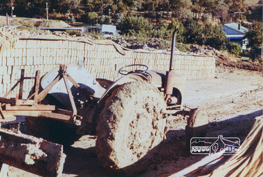
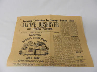 Kiewa Valley Historical Society
Newspaper Article - Tawonga School Centenary 1980 x2, Alpine Courier incorporating The Hydro Courier, 1980
This newspaper article was produced at a time when newspapers were the main source of local information. The period before the explosion of mobile communication technology and the cost effectiveness of communication by "texting" and internet "social connections, eg. facebook and other social media networkings" The newspapers were the main links between and within large regions. The Hydro Courier was first printed in 1950 as a YMCA community service publication by Mr. Albert Clarke YMCA Officer and Mr. Alex McCullough a State Electricity Commission employee. This paper was one very important publication that provided relevant community information to all and was the major contributer to the "Valley" cohesive fibre and unity. This article not only records the celebration (centenary) of the Tawonga School but also presents the history of the school and important events such as various relocations of classrooms and how the region was settled and developed from the 1870's onward. The yawonga school opened in 1880 on 8 acres of land. It consisted of one large wooden building (22 ft x 11 ft). It had two windows, one brick chimney, bare wooden floor and a shingle roof. This article also presents the time when Mount Beauty area was likened to an island and occasionally school children could not attend school because of a flooded Kiewa river. The article also covers the changes brought about by the increased employment opportunities from SEC Kiewa Works(1935), the Sawmill(1946), the Gold mine(1949) and the Tobacco Industry (largest growing area in Australia).This item is a one page (original) article of the centenary celebrations for Tawonga Primary School came from the Alpine Observer and incorporated the Hydro Courier. It covers the arrangements for the celebration of the 100 years of the school's existence. The printed layout is typical of the typeset in use in 1980's. There are seven distinctive type collumns separated by a printed line. Three photographs are published with one photograph of a demountable classromm ,circa 1980, and the other two of student class photos of 1899 and 1914. Teacher and student names are listed below each photograph. On the back of this page are "specials" for "Sam's Cut Price Stores", specifically the Myrtleford store. Of interest is the advertisement of "Cartons of Cigarettes at cut prices". The page was produced as part of a "run" with "telltale" holes at each corner for stabilising the page in the printing process."Centenary Celebrations For Tawonga Primary School" below this in an enclosed heading "ALPINE OBSERVER" underneath in smaller print "WITH WHICH IS INCORPORATED" below this in larger print "THE HYDRO COURIER" and below this from left to right, "No. 719 (Vol. 3) THURSDAY, 23rd OCTOBER, 1980" next "in smaller print Recommended Price Single Copy, 20c "(cents)rural school development, tawonga school centenary, kiewa valley development 1880 to 1980 -
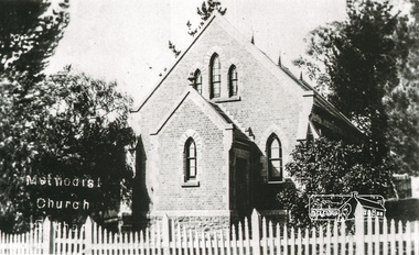 Eltham District Historical Society Inc
Photograph, Tom Prior, Methodist Church, Eltham
Situated at 810 Main Road on the corner of John Street. The Church was surrounded by a picket fence and tall pine trees. The Church was built by George Stebbings in the 1850s and is an example of fine craftmanship. Formerly Wesleyan, Methodist then Uniting church; the foundations of the church building were constructed with stone from the walls of the first Eltham State Primary School (No. 209) building which collapsed in 1874 and were purchased by Robert David Taylor. The Reynolds/Prior Photograph Collection, Presented to the Eltham District Historical Society, 14 June 2006 by Ross McDonald. A second copy was also presented to the Andrew Ross Museum, Kangaroo Ground The Reynolds family were early settlers in Research. Reynolds Road is named after this family. RERVISED STATEMENT OF SIGNIFICANCE, CONTEXT, 2010 What is significant? The 1880 bichromatic brick church and the surrounding site to the title boundaries. The church is architecturally, historically, socially and spiritually significant to the Shire of Nillumbik. Why is it significant? The church is architecturally significant as a finely detailed example of a brick 19th century rural community church, one of only four in the Shire (Criteria E & B). The church is historically significant as an important link with the time when Eltham was a small, insular country settlement. Also for the historical evolution visible in the complex, with the modest 1880s church and larger red brick rear hall from the early 20th century as a reflection of population growth in the area (Criterion A). The church is historically, spiritually and socially significant because it has played, and continues to play, an important part in the spiritual and social life of the community (Criterion G). - Victorian Heritage Database The Reynolds family were early settlers in Research. The Reynolds/ Prior collection of photographs were taken by Tom Prior, the maternal uncle of Ivy Reynolds, around 1900 and the 60 photos in the album give a fine overview of many of the landmarks of Research and Eltham over 100 years ago. lvy lived in the family home for many years at 106 Thompson Cres Research. Ivy's father, Ernst Richard Reynolds and grandfather, Richard Reynolds, lived at the same address. Ivy's father Richard worked for Mr. Trail on his property in Research. Reynolds Road is named after the family. Mr Tom Prior (wife Eva) worked at the Melbourne zoo. He was very innovative and made his own camera, using the black cloth hood to exclude the light. The photographs are a reminder of the rural nature of Research and Eltham and its rich heritage. Black and white photograph mounted in an album, the Reynolds/Prior Photograph Collection, this being one of 53 reproduced black and white images of early Eltham."Methodist Church" reynolds prior collection, eltham, methodist church -
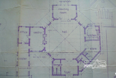 Eltham District Historical Society Inc
Photograph, An early design for St Margaret's mudbrick hall by architect, Robert Marshall which was not adopted for construction in 1978
Digital scan of photograph - Original Source Copy: St Margaret's Parish Archives. church of england, churches, eltham, st margarets church, mud bricks, robert marshall -
 Eltham District Historical Society Inc
Photograph, South side of the house looking east towards brick storage shed, Eltham Living and Learning Centre
Black and white photographeltham living and learning centre -
 Eltham District Historical Society Inc
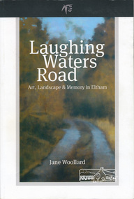
Book, Shire of Nillumbik, Laughing Waters Road: art, landscape & memory by Jane Woollard, 2016
"Laughing Waters has been a source of inspiration for many artists and designers, and was a natural extension of the dynamic art and lifestyle movement that began in the 1930s at Montsalvat. It was also an important site in the development of the Melbourne art scene in the 1960s and '70s, especially the earth building movement known as the Eltham Style. Since 2001 more than eighty artists have been in residence at Laughing Waters in Birrarung House and Riverbend. Their experiences and art making are woven together with Wurundjeri, European and family histories to create an evocative account of a special place in a bushy outer suburb of Melbourne." -- back cover. Eltham District Historical Society is acknowledged in the Acknowledgments section of this book.264 pages : illustrations, maps, portraits ISBN 9780994486707laughing waters, eltham, yarra river, artists, killeavey, mud bricks -
 Eltham District Historical Society Inc
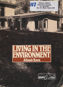
Book, Alistair Knox 1912-1986, Living in the environment / Alistair Knox, 1978
First published in 1975Paperback; 150 pages : illustrations ; 24 cm.ISBN 090813648X [written on flyleaf] To Norma Travis(?) from Alistair Knox 2/12/78houses, buildings, mudbrick, mud brick construction, alistair knox -
 Eltham District Historical Society Inc
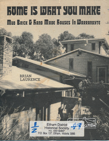
Book, Brian Laurence, Home is what you make : mud brick & hand made houses in Warrandyte / Brian Laurence, 1982c
Paperback; 8 p. : ill. ; 22 cmwarrandyte, houses, mudbrick -
 Eltham District Historical Society Inc
Photograph, Peter Bassett-Smith, Heritage Week at 728 Main Road, Eltham, 1990, 1990
Three colour photographs of Heritage Week featuring the brickwork of the former Police Residence and current home of Eltham District Historical Society at 728 Main Road, Eltham. Highlights the use of 'English Bond' on headers and stretchers alternatively and 'Colonial Bond' on one course of headers and three courses of stretchers.heritage week, eltham, courthouse, brick laying, wall, sign, activities -
 Eltham District Historical Society Inc
Photograph, Eltham Methodist Church, 1909, 1909
Situated at 810 Main Road on the corner of John Street. The Church was surrounded by a picket fence and tall pine trees. The Church was built by George Stebbings in the 1850s and is an example of fine craftmanship. Formerly Wesleyan, Methodist then Uniting church; the foundations of the church building were constructed with stone from the walls of the first Eltham State Primary School (No. 209) building which collapsed in 1874 and were purchased by Robert David Taylor. REVISED STATEMENT OF SIGNIFICANCE, CONTEXT, 2010 via Victorian Heritage Database What is significant? The 1880 bichromatic brick church and the surrounding site to the title boundaries. How is it significant? The church is architecturally, historically, socially and spiritually significant to the Shire of Nillumbik. Why is it significant? The church is architecturally significant as a finely detailed example of a brick 19th century rural community church, one of only four in the Shire (Criteria E & B). The church is historically significant as an important link with the time when Eltham was a small, insular country settlement. Also for the historical evolution visible in the complex, with the modest 1880s church and larger red brick rear hall from the early 20th century as a reflection of population growth in the area (Criterion A). The church is historically, spiritually and socially significant because it has played, and continues to play, an important part in the spiritual and social life of the community (Criterion G).Sepia postcard of Eltham Methodist Church, 1909eltham, methodist church, church, state school no. 209, eltham state school, robert david taylor, eltham uniting church, uniting church, wesleyan church -
 Eltham District Historical Society Inc
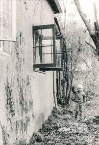
Photograph, Making mud bricks, 1970c
Reproduced on p110 of 'Pioneers & Painters' Individual identified as Tony Jackson. See also SEPP_0789Black and white photograph printpioneers and painters, mudbrick, sepp, tony jackson -
 Eltham District Historical Society Inc
Photograph, Rocknall, Diamond Street, Eltham, June 1990, 1990
Colour photograph of Rocknall, Diamond Street, Elthamhouses, pise construction, mud brick construction, rocknall, diamond street, eltham -
 Eltham District Historical Society Inc
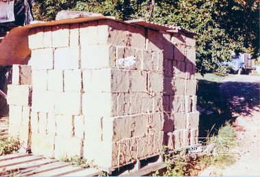
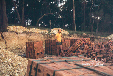
Photograph, Peter Vermey in excavation for garage with with stacks of bricks
14 Stokes Place (Lot 83) was the home of Peter and Carla Vermey. The land was purchased in May 1979 and construction commenced September 1979. The home was built by Peter and Carla Vermey after the developer, Macquarie Builders went bankrupt. Sold October 2017 by Morrison and Kleeman Real Estate. Stokes Place was part of the Stokes Orchard Estate which was developed from the break-up of the the orchard owned by Frank Stokes who lived on the northeast corner of Nyora Road and Eucalyptus Road. His daughter Beryl advised that the Shire had levied a rate assessment on individual parcels of land within the orchard which became unaffordable resulting in its sub-division and sell off. The Stokes Orchard Estate was developed by Macquarie Builders in two stages starting with stage 1 in 1976. Stokes Place was part of Stage 2 in 1979. The Estate was bounded between Nyora Road, Eucalyptus Road, Diosma Road and Stokes Place. The original orchard only just reached the left most portions of Stokes Place and did not go fully up to Diosma, rather to just beyond the extant of Stokes Place. Stokes Place was known within the family as "The Oats" as that is where they grew oats. Frank Stokes moved to Eltham c.1945 after visiting Harold Bird to view his orchard, located diagonally opposite Stokes Orchard from the intersection of Eucalyptus Road, Pitt Street and Nyora Road. It was on Harold Bird's recommendation that Frank purchased the land.The Stokes Orchard Estate collection is typical of housing developments of the late 1970s and 1980s. It was one of the earliest estates in Eltham following the nearby Woodridge Estate development.Digital fileScanned by EDHS from 49 x 35mm colour transparencies provided on loanstokes place, eltham, stokes orchard, stokes orchard estate, streets, houses, peter and carla vermey -
 Eltham District Historical Society Inc
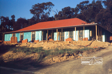
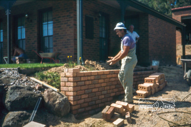
Photograph, House from front, being bricked
14 Stokes Place (Lot 83) was the home of Peter and Carla Vermey. The land was purchased in May 1979 and construction commenced September 1979. The home was built by Peter and Carla Vermey after the developer, Macquarie Builders went bankrupt. Sold October 2017 by Morrison and Kleeman Real Estate. Stokes Place was part of the Stokes Orchard Estate which was developed from the break-up of the the orchard owned by Frank Stokes who lived on the northeast corner of Nyora Road and Eucalyptus Road. His daughter Beryl advised that the Shire had levied a rate assessment on individual parcels of land within the orchard which became unaffordable resulting in its sub-division and sell off. The Stokes Orchard Estate was developed by Macquarie Builders in two stages starting with stage 1 in 1976. Stokes Place was part of Stage 2 in 1979. The Estate was bounded between Nyora Road, Eucalyptus Road, Diosma Road and Stokes Place. The original orchard only just reached the left most portions of Stokes Place and did not go fully up to Diosma, rather to just beyond the extant of Stokes Place. Stokes Place was known within the family as "The Oats" as that is where they grew oats. Frank Stokes moved to Eltham c.1945 after visiting Harold Bird to view his orchard, located diagonally opposite Stokes Orchard from the intersection of Eucalyptus Road, Pitt Street and Nyora Road. It was on Harold Bird's recommendation that Frank purchased the land.The Stokes Orchard Estate collection is typical of housing developments of the late 1970s and 1980s. It was one of the earliest estates in Eltham following the nearby Woodridge Estate development.Digital fileScanned by EDHS from 49 x 35mm colour transparencies provided on loanstokes place, eltham, stokes orchard, stokes orchard estate, streets, houses, peter and carla vermey -
 Eltham District Historical Society Inc
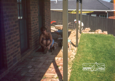
Photograph, Nick building brick wall along driveway, February 1982
14 Stokes Place (Lot 83) was the home of Peter and Carla Vermey. The land was purchased in May 1979 and construction commenced September 1979. The home was built by Peter and Carla Vermey after the developer, Macquarie Builders went bankrupt. Sold October 2017 by Morrison and Kleeman Real Estate. Stokes Place was part of the Stokes Orchard Estate which was developed from the break-up of the the orchard owned by Frank Stokes who lived on the northeast corner of Nyora Road and Eucalyptus Road. His daughter Beryl advised that the Shire had levied a rate assessment on individual parcels of land within the orchard which became unaffordable resulting in its sub-division and sell off. The Stokes Orchard Estate was developed by Macquarie Builders in two stages starting with stage 1 in 1976. Stokes Place was part of Stage 2 in 1979. The Estate was bounded between Nyora Road, Eucalyptus Road, Diosma Road and Stokes Place. The original orchard only just reached the left most portions of Stokes Place and did not go fully up to Diosma, rather to just beyond the extant of Stokes Place. Stokes Place was known within the family as "The Oats" as that is where they grew oats. Frank Stokes moved to Eltham c.1945 after visiting Harold Bird to view his orchard, located diagonally opposite Stokes Orchard from the intersection of Eucalyptus Road, Pitt Street and Nyora Road. It was on Harold Bird's recommendation that Frank purchased the land.The Stokes Orchard Estate collection is typical of housing developments of the late 1970s and 1980s. It was one of the earliest estates in Eltham following the nearby Woodridge Estate development.Digital fileScanned by EDHS from 49 x 35mm colour transparencies provided on loanstokes place, eltham, stokes orchard, stokes orchard estate, streets, houses, peter and carla vermey -
 Eltham District Historical Society Inc
Photograph, Carla Vermey under front verandah cleaning bricks, February 1982
14 Stokes Place (Lot 83) was the home of Peter and Carla Vermey. The land was purchased in May 1979 and construction commenced September 1979. The home was built by Peter and Carla Vermey after the developer, Macquarie Builders went bankrupt. Sold October 2017 by Morrison and Kleeman Real Estate. Stokes Place was part of the Stokes Orchard Estate which was developed from the break-up of the the orchard owned by Frank Stokes who lived on the northeast corner of Nyora Road and Eucalyptus Road. His daughter Beryl advised that the Shire had levied a rate assessment on individual parcels of land within the orchard which became unaffordable resulting in its sub-division and sell off. The Stokes Orchard Estate was developed by Macquarie Builders in two stages starting with stage 1 in 1976. Stokes Place was part of Stage 2 in 1979. The Estate was bounded between Nyora Road, Eucalyptus Road, Diosma Road and Stokes Place. The original orchard only just reached the left most portions of Stokes Place and did not go fully up to Diosma, rather to just beyond the extant of Stokes Place. Stokes Place was known within the family as "The Oats" as that is where they grew oats. Frank Stokes moved to Eltham c.1945 after visiting Harold Bird to view his orchard, located diagonally opposite Stokes Orchard from the intersection of Eucalyptus Road, Pitt Street and Nyora Road. It was on Harold Bird's recommendation that Frank purchased the land.The Stokes Orchard Estate collection is typical of housing developments of the late 1970s and 1980s. It was one of the earliest estates in Eltham following the nearby Woodridge Estate development.Digital fileScanned by EDHS from 49 x 35mm colour transparencies provided on loanstokes place, eltham, stokes orchard, stokes orchard estate, streets, houses, peter and carla vermey -
 Marysville & District Historical Society
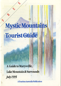
Ephemera (Item) - Tourist Guide, Graeme Haycraft, Mystic Mountains Tourist Guide July 1995, 07-1995
A tourist guide outlining services, accommodation, activities and places of interest to visit in and around Marysville, Lake Mountain and the local district.A tourist guide outlining services, accommodation, activities and places of interest to visit in and around Marysville, Lake Mountain and the local district.Acknowledgements/ Mystic Mountains Tourism Association, Marysville Office of the Dept. of Conser/ vation & Natural Resources, Mrs Elaine Postlethwaite, Ms Sue Henry & every/ advertiser without whose support this Guide would not have been possible.marysville, victoria, australia, tourist guide, mystic mountains, lake mountain, tourism australia, graeme haycraft, magic creek nursery, missing links miniature golf, phelps bakery, blackwood cottages, marysville hotel motel, tower motel, kerami house, marylands guest house, lomatia lodge, willowbank at taggerty, barree mud brick cottages, scenic motel, somerled mountain retreat, dalrymples guest cottages, nanda binya lodge, mathilde's of marysville country guest house, the birches resort, mystic mountains tourist information, marysville caravan park, the cumberland, igloo roadhouse, top shop pancake parlour, the silver birch restaurant, steavenson's restaurant, olde yarra track shoppe, danish coffee gardens, oscars take-away, country touch pottery studio & gallery, cumberland memorial scenic reserve, cathedral range state park, lady talbot forest drive, wishing well, taggerty river picnic area, taggerty river, phantom falls, keppels falls, the beeches walking track, mount sugarloaf, maryton park holiday cottages, snowviews, esa camping & conference centre, wirreanda festival, marysville post shop, hidden talent craft gallery, marysville automotive repairs, geoffrey pope & associates, beauty spot walk, tree fern gully walk, michaeldene track, marysville riding school, gerraty's ski centre, marysville holiday cottages, marysville triangle taxi service, fruit salad farm, lake mountain alpine resort, marysville ski hire, lake mountain ski school, cross country ski hire, lake mountain ski hire, marysville country club -
 Marysville & District Historical Society
Newspaper (Item) - Newspaper article, The Age, POCKET GUIDE TO MARYSVILLE, 22-11-2008
A newspaper article on Marysville, its local attractions, places to shop and dine, where to stay and ways of traveling to Marysville. This article was published in The Age on Saturday, November 22, 2008.A newspaper article on Marysville, its local attractions, places to shop and dine, where to stay and ways of traveling to Marysville.marysville, victoria, australia, the age, black spur, marysville visitor information centre, steavenson falls, lady talbot drive, taggerty river, keppel falls, phantom falls, beeches rainforest walk, cambarville, yarra ranges national park, the big tree, cumberland walk, lake mountain, steavenson river, acheron river, buxton bait and tackle, marysville trout and salmon ponds, buxton trout and salmon farm, bruno's art and sculpture garden, villa day spa, cathedral view natural therapies, marysville massage, murchison street, village walk, uncle fred & aunty val's old style lolly shop, country touch gallery, manical mechanicals, hidden talent craft gallery, carmyle farm boutique, marysville community market, marysville patisserie, marysville country bakery, fraga's cafe restaurant, terracotta room, marylands country house, the cumberland, mantirri blueberry farm, narbethong, marysville farmers market, the black spur inn, allawah country cottages, barree mud brick cottages