Showing 4280 items matching " prior"
-
 Eltham District Historical Society Inc
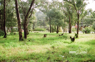
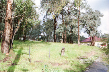
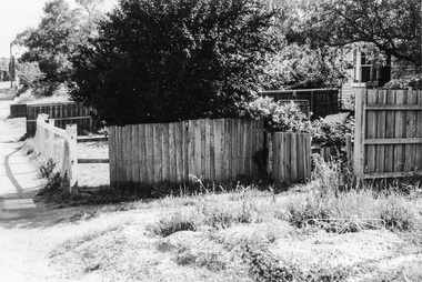
Photograph, Vacant land at 816 Heidelberg-Kinglake Road, Hurstbridge, c.1980, 1980c
Streetscape evolution; prior to development of reserve for housing units and redevelopment of shops opposite Hurstbridge Railway StationRoll of 35mm colour negative film, 4 stripsKodak GB 200 5096streets, heidelberg-kinglake road, hurstbridge, railway station -
 Eltham District Historical Society Inc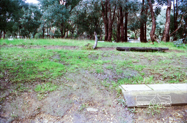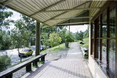
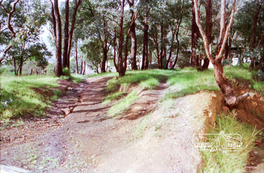
Photograph, Vacant land at 816 Heidelberg-Kinglake Road, Hurstbridge, c.1980, 1980c
Streetscape evolution; prior to development of reserve for housing units and redevelopment of shops opposite Hurstbridge Railway StationRoll of 35mm colour negative film, 4 stripsKodak GB 200 5096streets, heidelberg-kinglake road, hurstbridge, railway station -
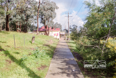
 Eltham District Historical Society Inc
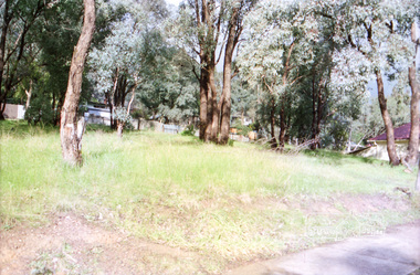
Photograph, Milk Bar at 808 and vacant land at 816 Heidelberg-Kinglake Road, Hurstbridge, c.1980, 1980c
Streetscape evolution; prior to development of reserve for housing units and redevelopment of shops opposite Hurstbridge Railway StationRoll of 35mm colour negative film, 4 stripsKodak GB 200 5096streets, heidelberg-kinglake road, hurstbridge, milk bar, bendigo bank, railway station -
 Eltham District Historical Society Inc
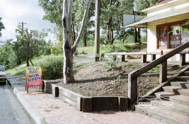
Photograph, Milk Bar at 808 and vacant land at 816 Heidelberg-Kinglake Road, Hurstbridge, c.1980, 1980c
Streetscape evolution; prior to development of reserve for housing units and redevelopment of shops opposite Hurstbridge Railway StationRoll of 35mm colour negative film, 4 stripsKodak GB 200 5096streets, heidelberg-kinglake road, hurstbridge, milk bar, bendigo bank, railway station -
 Eltham District Historical Society Inc
Photograph, Milk Bar at 808 and vacant land at 816 Heidelberg-Kinglake Road, Hurstbridge, c.1980, 1980c
Streetscape evolution; prior to development of reserve for housing units and redevelopment of shops opposite Hurstbridge Railway StationRoll of 35mm colour negative film, 4 stripsKodak GB 200 5096streets, heidelberg-kinglake road, hurstbridge, milk bar, bendigo bank, railway station -
 Kiewa Valley Historical Society
Black and White photograph of Road Making Machinery, Kiewa Road Making, 25/08/1938
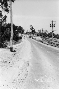
Construction of the main road from South Tawonga to the Bogong High Plains, to provide access to the construction sites for the new Kiewa Hydro Electric Scheme, was commenced early in 1938, the work being undertaken on behalf of the Commission by the Country Roads Board. For the construction work, the Commission purchased three Caterpillar - model R07 - diesel crawler tractors equipped with Kay Brunerei (Brunner) hydraulically operated trailbuilders (angle dozers). This acquisition resulted from a visit to the United States of America in May, 1937 by the Construction Engineer ( Mr. C.H. Kernot) and Assistant Civil Engineer (Mr. J.F. Douglas) where they saw this relatively new type of equipment in use. With the co-operation of the CRB, the Commission demonstrated the operation of these machines at Fishermen's Bend on 6th April, 1938. They were then sent to Kiewa where they commenced operation towards the end of the month. From South Tawonga, the route led immediately across the Western Branch of the Kiewa River necessitating the construction of a bridge 100 feet long. By the end of 1939, the excavation had been 'opened up' for a distance of 19 1/2 miles (approx. 31 km) and of this length, 10 miles (approx. 16 km) had been surfaced.The purchase and use of this type of mechanical equipment in road making was a huge investment, as prior to this most of the work would have been done manually with the use of picks and shovels. Not only were many months of hard manual labour saved, but a very significant amount of time in providing access to the proposed work sites for the new Kiewa Hydro Scheme. This photo is an excellent reminder of how primitive the early machinery was compared to the present but also represents the forward thinking of the State Electricity Commissions engineers in purchasing such innovative equipment . A black and white photograph showing the type of machinery used for road making in the 1930's. It shows a grader being towed by a caterpillar tractor.On the top left hand corner of the photograph , hand written in black ink is the words 'Kiewa Road Making 25/8/1938'. On the right hand side of the photo has been stamped in blue the Number 1. It has been developed on Velox paper (marked on back of photo) with a gloss finish.road making, state electricity commission, caterpillar tractor, kiewa -
 Kiewa Valley Historical Society
Black and White photograph of Road Making Machinery, Kiewa Road Making 25/08/1938 No. 2, 25/08/1938
Construction of the main road from South Tawonga to the Bogong High Plains, to provide access to the construction sites for the new Kiewa Hydro Electric Scheme, was commenced early in 1938, the work being undertaken on behalf of the commission by the Country Roads Board. For the construction work, the Commission purchased three Caterpillar - model R07 - diesel crawler tractors equipped with Kay Brunerei (Brunner) hydraulically operated trailbuilders (angle dozers). This acquisition resulted from a visit to the United States of America in May, 1937 by the Construction Engineer ( Mr. C.H. Kernot) and Assistant Civil Engineer ( Mr. J.F. Douglas) where they saw this relatively new type of equipment in use. With the co-operation of the CRB, the Commission demonstrated the operation of these machines at Fishermen's Bend on 6th April, 1938. They were then sent to Kiewa where they commenced operation towards the end of the month. From South Tawonga, the route let immediately across the Western Branch of the Kiewa River necessitating the construction of a bridge 100 feet long. By the end of 1939, the excavation had been 'opened up' for a distance of 19 1/2 miles (approx. 31 km.) and of this length, 10 miles (approx. 16 km.) had been surfaced. (see KVHS 0328)The purchase of this type of mechanical equipment in road making was a huge investment, as prior to this most of the work would have been done manually with the use of picks and shovels. Not only were many months of hard manual labour saved, but a very significant amount of time in providing access to the proposed work sites for the new Kiewa Hydro Scheme. This photo is an excellent reminder of how primitive the early machinery was compared to the present but also represents the forward thinking of the State Electricity Commissions engineers in purchasing such innovative equipment.A black and white photograph of road making near Mt. Beauty in 1938. Mount Beauty hills can be seen in the background with cleared land for grazing in the fore ground.Hand printed in black ink at the top of the photograph is 'Kiewa Road Making 25/8/1938'. On the right hand corner has been printed the number 2. It has been printed on gloss Velox paper.road making, state electricity commission, caterpillar tractor, kiewa, secv -
 Kiewa Valley Historical Society
Black and White photograph of Road Making Machinery, Kiewa Road Making 25/8/1938(No. 3 in a series of 8), 25/08/1938
Construction of the main road from South Tawonga to the Bogong High Plains, to provide access to the construction sites for the new Kiewa Hydro Electric Scheme, was commenced early in 1938, the work being undertaken on behalf of the Commission by the Country Roads Board. For the construction work, the Commission purchased three Caterpillar - model R07 - diesel crawler tractors equipped with Kay Brunerei (Brunner) hydraulically operated trail builders (angle dozers)). This acquisition resulted from a visit to the United States of America in May, 1937 by the Construction Engineer ( Mr. C.H. Kernot) and Assistant Civil Engineer (Mr. J.F. Douglas) where they saw this relatively new type of equipment in use. With the co-operation of the CRB, the Commission demonstrated the operation of these machines at Fishermen's Bend on 6th April, 1938. They were then sent to Kiewa where they commenced operation towards the end of the month. From South Tawonga, the route led immediately across the Western Branch of the Kiewa River necessitating the construction of a bridge 100 feet long. By the end of 1939,the excavation had been 'opened up' for a distance of 19 1/2 miles (approx. 31 km.) and of this length, 10 miles (approx. 16 km) had been surfaced.The purchase and use of this type of mechanical equipment in road making was a huge investment, as prior to this most of the work would have been done manually with the use of picks and shovels. Not only were many months of hard manual labour saved, but a very significant amount of time in providing access to the proposed work sites for the new Kiewa Hydro Scheme. This photo is an excellent reminder of how primitive the early machinery was compared to the present but also represents the forward thinking of the State Electricity Commission's Engineers in purchasing such new and innovative equipment.A black and white photograph of a Caterpillar diesel crawler tractor and a hydraulically operated trailbuilder (angle dozer) making a road in the Mt. Beauty area.Hand written in black ink in the top left hand corner are the words "Kiewa Road Making 25/8/1938". On the upper right hand of the photograph has been stamped the number 3. On the back is stamped the word 'Velox' severaly times, which is the make of the photograhic paper. roadmaking, caterpillar tractor, kiewa, state electricity commission -
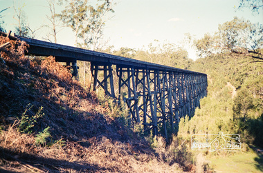 Eltham District Historical Society Inc
Photograph, Stony Creek Trestle bridge, 1990, 1990
A trestle bridge in comparison to Eltham's Railway Trestle Bridge. Position on roll of film is immediately prior to unveiling of Walter Withers commemorative plaque in Walter Withers Reserve, Eltham. Roll of 35mm colour negative film, 1 stripFuji 100 Ntrestle bridge, stony creek -
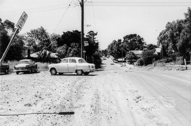 Eltham District Historical Society Inc
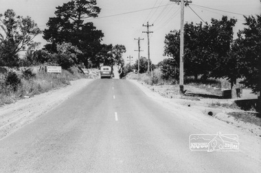
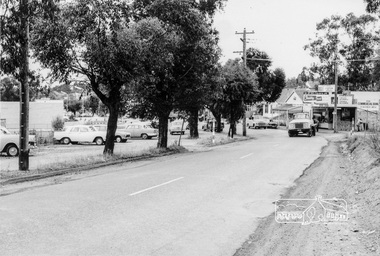
Photograph, Intersection of Main Road and Pitt Street, Eltham, February 1968, Feb 1968
Shows sign to St Margaret's Church and also front of the Methodist Church building.In February 1968 an unknown person took a series of photos from the Eltham Hotel at Pitt Street heading north along Main Road through the shopping centre to just north of Elsa Court covering the length of the section of Main Road which was duplicated shortly thereafter. Shows the condition and environment of the streesscape of Main Road, Eltham immediately prior to the duplication between Pitt Street and Elsa Court through the shopping centre. Also shows a number of shops and businesses that operated at that time.Black and white photographduplication, st margarets anglican church, eltham, main road, methodist church, pitt street -
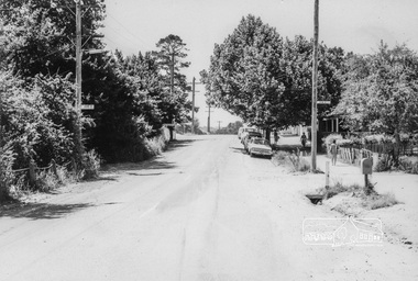 Eltham District Historical Society Inc
Photograph, Looking North along Main Road near intersection with John Street, Eltham, February 1968, Feb 1968
Shows cars parked outside Burgoyne's store on the east side In February 1968 an unknown person took a series of photos from the Eltham Hotel at Pitt Street heading north along Main Road through the shopping centre to just north of Elsa Court covering the length of the section of Main Road which was duplicated shortly thereafter. Shows the condition and environment of the streesscape of Main Road, Eltham immediately prior to the duplication between Pitt Street and Elsa Court through the shopping centre. Also shows a number of shops and businesses that operated at that time.Black and white photographduplication, eltham, main road, burgoyne's shop, john street -
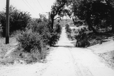 Eltham District Historical Society Inc
Photograph, Looking west along Bridge Street and across intersection at Main Road, Eltham, February 1968, Feb 1968
In February 1968 an unknown person took a series of photos from the Eltham Hotel at Pitt Street heading north along Main Road through the shopping centre to just north of Elsa Court covering the length of the section of Main Road which was duplicated shortly thereafter. Shows the condition and environment of the streesscape of Main Road, Eltham immediately prior to the duplication between Pitt Street and Elsa Court through the shopping centre. Also shows a number of shops and businesses that operated at that time.Black and white photographduplication, eltham, main road -
 Eltham District Historical Society Inc
Photograph, Looking southwest across Main Road at the intersection with Bridge Street, Eltham, February 1968, Feb 1968
Showing one of several housesIn February 1968 an unknown person took a series of photos from the Eltham Hotel at Pitt Street heading north along Main Road through the shopping centre to just north of Elsa Court covering the length of the section of Main Road which was duplicated shortly thereafter. Shows the condition and environment of the streesscape of Main Road, Eltham immediately prior to the duplication between Pitt Street and Elsa Court through the shopping centre. Also shows a number of shops and businesses that operated at that time.Black and white photographduplication, eltham, main road -
 Eltham District Historical Society Inc
Photograph, Looking west along Bridge Street, from Main Road, Eltham, February 1968, Feb 1968
Shows the Diamond Creek bridge and part of Susan Street In February 1968 an unknown person took a series of photos from the Eltham Hotel at Pitt Street heading north along Main Road through the shopping centre to just north of Elsa Court covering the length of the section of Main Road which was duplicated shortly thereafter. Shows the condition and environment of the streesscape of Main Road, Eltham immediately prior to the duplication between Pitt Street and Elsa Court through the shopping centre. Also shows a number of shops and businesses that operated at that time.Black and white photographduplication, eltham, main road, bridge street, susan street -
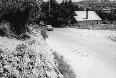
 Eltham District Historical Society Inc
Photograph, Intersection of Main Road and Bridge Street, Eltham, February 1968, Feb 1968
Shows a VW Beetle (GVM-459) heading east up the hill on Bridge Street continuance which at the time was slightly mis-aligned. Also street direction signs to Greensborough, Montmorency and St Helena.In February 1968 an unknown person took a series of photos from the Eltham Hotel at Pitt Street heading north along Main Road through the shopping centre to just north of Elsa Court covering the length of the section of Main Road which was duplicated shortly thereafter. Shows the condition and environment of the streesscape of Main Road, Eltham immediately prior to the duplication between Pitt Street and Elsa Court through the shopping centre. Also shows a number of shops and businesses that operated at that time.Black and white photographduplication, eltham, main road, bridge street -
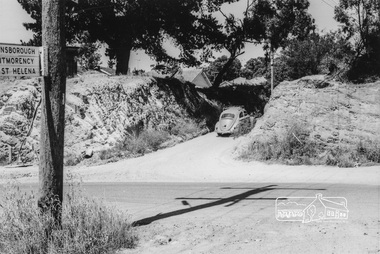
 Eltham District Historical Society Inc
Photograph, Intersection of Main Road and Bridge Street, Eltham, February 1968, Feb 1968
Shows street signs on pole for Greensborough, Montmorency and St HelenaIn February 1968 an unknown person took a series of photos from the Eltham Hotel at Pitt Street heading north along Main Road through the shopping centre to just north of Elsa Court covering the length of the section of Main Road which was duplicated shortly thereafter. Shows the condition and environment of the streesscape of Main Road, Eltham immediately prior to the duplication between Pitt Street and Elsa Court through the shopping centre. Also shows a number of shops and businesses that operated at that time.Black and white photographduplication, eltham, main road, bridge street -
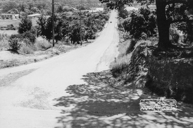
 Eltham District Historical Society Inc
Photograph, Looking up Bridge Street to the intersection with Main Road, Eltham, February 1968, Feb 1968
Shows the Eltham-Melbourne directional sign on left hand sideIn February 1968 an unknown person took a series of photos from the Eltham Hotel at Pitt Street heading north along Main Road through the shopping centre to just north of Elsa Court covering the length of the section of Main Road which was duplicated shortly thereafter. Shows the condition and environment of the streesscape of Main Road, Eltham immediately prior to the duplication between Pitt Street and Elsa Court through the shopping centre. Also shows a number of shops and businesses that operated at that time.Black and white photographduplication, eltham, main road, bridge street -
 Eltham District Historical Society Inc
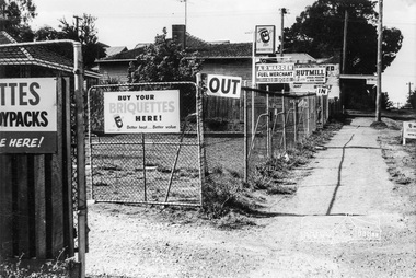
Photograph, Looking south along the east side of Main Road towards York Street, Eltham, February 1968, Feb 1968
Shows Eltham Stock and Poultry Feed Store. Site of current Le Pine Funeral Home In February 1968 an unknown person took a series of photos from the Eltham Hotel at Pitt Street heading north along Main Road through the shopping centre to just north of Elsa Court covering the length of the section of Main Road which was duplicated shortly thereafter. Shows the condition and environment of the streesscape of Main Road, Eltham immediately prior to the duplication between Pitt Street and Elsa Court through the shopping centre. Also shows a number of shops and businesses that operated at that time.Black and white photographduplication, eltham, main road, briquettes, fuel merchant, le pine funeral home, york street, a.r warren, eltham feed store -
 Eltham District Historical Society Inc
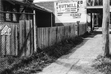
Photograph, Looking south along the east side of Main Road from Henry Street to Bridge Street, Eltham, February 1968, Feb 1968
Shows Warrens Fuel Merchant yard and Eltham Feed Store. Site of current Le Pine Funeral Home In February 1968 an unknown person took a series of photos from the Eltham Hotel at Pitt Street heading north along Main Road through the shopping centre to just north of Elsa Court covering the length of the section of Main Road which was duplicated shortly thereafter. Shows the condition and environment of the streesscape of Main Road, Eltham immediately prior to the duplication between Pitt Street and Elsa Court through the shopping centre. Also shows a number of shops and businesses that operated at that time.Black and white photographduplication, eltham, main road, briquettes, fuel merchant, le pine funeral home, york street, a.r warren, eltham feed store -
 Eltham District Historical Society Inc
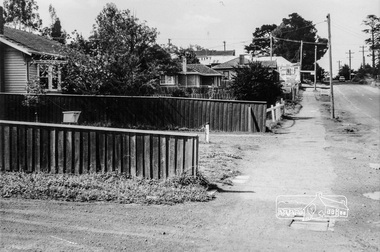
Photograph, Looking north from the east side of Main Road between Henry and York Streets, Eltham, February 1968, Feb 1968
Eltham Shire Office and Shillinglaw trees to the left of photo In February 1968 an unknown person took a series of photos from the Eltham Hotel at Pitt Street heading north along Main Road through the shopping centre to just north of Elsa Court covering the length of the section of Main Road which was duplicated shortly thereafter. Shows the condition and environment of the streesscape of Main Road, Eltham immediately prior to the duplication between Pitt Street and Elsa Court through the shopping centre. Also shows a number of shops and businesses that operated at that time.Black and white photographduplication, eltham, main road, eltham shire offices, shillinglaw trees -
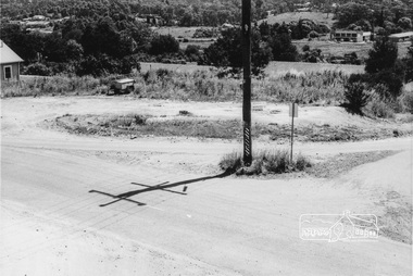
 Eltham District Historical Society Inc
Photograph, Looking south along Main Road towards Bridge Street from the intersection with Henry Street, Eltham, February 1968, Feb 1968
In February 1968 an unknown person took a series of photos from the Eltham Hotel at Pitt Street heading north along Main Road through the shopping centre to just north of Elsa Court covering the length of the section of Main Road which was duplicated shortly thereafter. Shows the condition and environment of the streesscape of Main Road, Eltham immediately prior to the duplication between Pitt Street and Elsa Court through the shopping centre. Also shows a number of shops and businesses that operated at that time.Black and white photographduplication, eltham, main road, bridge street, henry street -
 Eltham District Historical Society Inc
Photograph, Intersection of Main Road and Henry Street, Eltham, February 1968, Feb 1968
Shows the railway trestle bridge and Eltham Central ParkIn February 1968 an unknown person took a series of photos from the Eltham Hotel at Pitt Street heading north along Main Road through the shopping centre to just north of Elsa Court covering the length of the section of Main Road which was duplicated shortly thereafter. Shows the condition and environment of the streesscape of Main Road, Eltham immediately prior to the duplication between Pitt Street and Elsa Court through the shopping centre. Also shows a number of shops and businesses that operated at that time.Black and white photographduplication, eltham, main road, henry street, trestle bridge, eltham central park -
 Eltham District Historical Society Inc
Photograph, Our Lady's Church and school buildings on the east side of Main Road, Eltham, February 1968, Feb 1968
Shows car parking at left across Main RoadIn February 1968 an unknown person took a series of photos from the Eltham Hotel at Pitt Street heading north along Main Road through the shopping centre to just north of Elsa Court covering the length of the section of Main Road which was duplicated shortly thereafter. Shows the condition and environment of the streesscape of Main Road, Eltham immediately prior to the duplication between Pitt Street and Elsa Court through the shopping centre. Also shows a number of shops and businesses that operated at that time.Black and white photographduplication, eltham, main road, our ladys church -
 Eltham District Historical Society Inc
Photograph, Looking north along the east side of Main Road from near Henry Street, Eltham, February 1968, Feb 1968
Shows the Commercial Bank of Australia on the Dudley Street intersection and part of the War Memorial on the left amongst the parked cars.In February 1968 an unknown person took a series of photos from the Eltham Hotel at Pitt Street heading north along Main Road through the shopping centre to just north of Elsa Court covering the length of the section of Main Road which was duplicated shortly thereafter. Shows the condition and environment of the streesscape of Main Road, Eltham immediately prior to the duplication between Pitt Street and Elsa Court through the shopping centre. Also shows a number of shops and businesses that operated at that time.Black and white photographduplication, eltham, main road, commercial bank, eltham, dudley street, shire of eltham war memorial, arthur street, shopping centre, eltham shire office -
 Eltham District Historical Society Inc
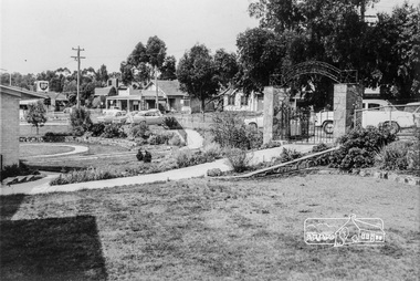
Photograph, Inside the garden of the War memorial with paths and entrance gates along Main Road, Eltham, February 1968, Feb 1968
Shows the east side shops between Arthur Street and Dudley Street and former Eltham Shire Offices. View is from the entrance of the Baby Health Centre. The roadway outside the gates was not made and was used for parking. The shops and an early fire station (near to left gate post) show the area before the Woolworths rebuilding of the area to Eltham.In February 1968 an unknown person took a series of photos from the Eltham Hotel at Pitt Street heading north along Main Road through the shopping centre to just north of Elsa Court covering the length of the section of Main Road which was duplicated shortly thereafter. Shows the condition and environment of the streesscape of Main Road, Eltham immediately prior to the duplication between Pitt Street and Elsa Court through the shopping centre. Also shows a number of shops and businesses that operated at that time.Black and white photographduplication, eltham, main road, dudley street, shire of eltham war memorial, arthur street, shopping centre, eltham shire office -
 Eltham District Historical Society Inc
Photograph, World War Two Memorial buildings on west side of Main Road, Eltham, February 1968, Feb 1968
Child Welfare Centre (opened 1952) and War Memorial Hall originally built for the Children's Library. Shows the Eltham Shire Office (built 1964) at left of photo.In February 1968 an unknown person took a series of photos from the Eltham Hotel at Pitt Street heading north along Main Road through the shopping centre to just north of Elsa Court covering the length of the section of Main Road which was duplicated shortly thereafter. Shows the condition and environment of the streesscape of Main Road, Eltham immediately prior to the duplication between Pitt Street and Elsa Court through the shopping centre. Also shows a number of shops and businesses that operated at that time.Black and white photographduplication, eltham, main road, shire of eltham war memorial, children's library, infant welfare centre