Showing 27536 items
matching yarra-river
-
 Whitehorse Historical Society Inc.
Document, Phylloxera vitifoliae, 1/07/2001 12:00:00 AM
Response to an e-mail query from Ted Arrowsmith as to the presence of Phylloxera vitifoliae in vineyards in the Yarra Valley in the late 1800's, early 1900's. There is no evidence it was present.Response to an e-mail query from Ted Arrowsmith as to the presence of Phylloxera vitifoliae in vineyards in the Yarra Valley in the late 1800's, early 1900's. There is no evidence it was present.Response to an e-mail query from Ted Arrowsmith as to the presence of Phylloxera vitifoliae in vineyards in the Yarra Valley in the late 1800's, early 1900's. There is no evidence it was present.phylloxera vitifoliae, viticulture -
 Lilydale RSL Sub Branch
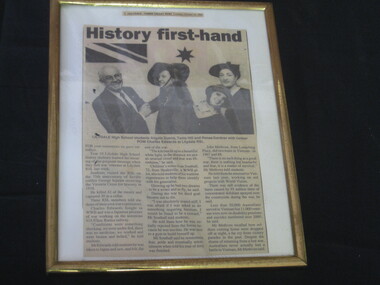
Newspaper - Framed newspaper article, 'History First Hand"
Article from Lilydale - Yarra Valley Post. Tuesday October 12 1993. Visit of year 10 Lilydale HS history students with former POW Charles Edwards. -
 Bendigo Military Museum
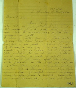
Letter, 22.7.1918
The letter is from Horace (Swag) LONG to Trixie who in other correspondence is called "Beat". Refer 11.4, 12.3. Horace LONG No 437, 9th & 4th LH Regt AIF. Refer Cat No 16P for his service details..1) - .3) Three pages of hand written letter on yellowed ruled paper..1) Top right: 22.7.18 Some where along the River Jordan. .3) From Swag the Dag.documents, letters, correspondence -
 Orbost & District Historical Society
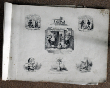
book / colection, early 19th century
George Cruikshank (27 September 1792 – 1 February 1878) was a British caricaturist and book illustrator.. His book illustrations for his friend Charles Dickens, and many other authors, reached an international audience. George Cruikshank was inventive. In the 1800's, puns and other forms of word-play were loved by all. Some of these illustrations come from his 'Scraps and Sketches' album, published for adults in 1832, though the drawings were done between 1828 and 1832. Volumes of George Cruikshank's Scraps and Sketches were intended to be cut and pasted in home-made albums and scrapbooks; George Cruikshank was a well-known British caricaturist and book illustrator. This item represents this popular art form of the early to mid 19th century.A collection of artworks (copies of etchings) of George Cruikshank. They are bound together with masking tape. The pages are dated 1828-1823. They are satirical cartoons printed in black ink.on front : "V BROOME with CANN RIVER crossed through ORBOST 78 PERRY ST 5154 2855" -
 Kew Historical Society Inc
Plan - Subdivision Plan, Kew Golf Links Estate, 1936, 1936
The Kew Golf Links Estate was a major subdivision in North Kew. It derived its title due to the land being previously occupied by the Kew Golf Club, which transferred its course to a number of locations before occupying its current site. The Plan advertises 180 choice home sites. The street names are somewhat different today as those on the map are named after the proposed Kodak Factory to be built on the site. The subdivision of the Kew Golf Links Estate was a major subdivision of farmland in Kew. The site was at one stage designated for industrial development and the building of a new Kodak factory. The decision by Council to oppose the redevelopment makes the beginning of the period when all industrial development was banned in Kew.Monochrome printed, folded subdivision plan for the Kew Golf Links Estate, to be auctioned on 7 November 1936. Streets named include: Carnegie Avenue, Willsmere Road, Kilby Boulevarde, Kodak Avenue, Coleman Avenue, Beresford Avenue, McConchie Avenue, Cole Avenue, White Avenue, Baker Avenue, Spruzen Avenue, Tanner Avenue, Ratten Avenue, Mathers Avenue, Railway Avenue, Sutherland Avenue, and Belford Road. The position of the Yarra River and a large Drainage Reserve are marked on the plan. Lots for sale are numbered. Existing buildings are designated with a square.subdivision plans - kew (vic), kodak factory - kew (vic) -
 Kew Historical Society Inc
Photograph - Zig-Zag Bridge on the Yarra River at Kew, 1924
Henry Beater Christian (1886-1962) , was a descendant of one of the earliest settler families in Kew. Employed at the Kew Asylum as a 'public servant', he was a skilled amateur photographer, photographing numerous scenes in Kew and on his travels around Victoria. The majority of his photographs date from 1916 to 1929. His finest photographs are housed in two photograph albums. Digital copy of a photograph from page 8 of the 47-page photograph album containing 261 gelatinous silver images, loaned by Diane Washfold with permission given to digitise and hold a copy in our collection. The Zig-Zag Bridge linked the grounds of the Yarra Bend and Kew Asylums. The wooden bridge was constructed in the 1870s and lasted through numerous floods until its destruction in 1929. A horizontal structure, the walkway was reached via a wooden staircase on the Kew side. The steps were required due to the different levels of the banks on this stretch of the river. "Zig-Zag Bridge"henry beater christian (1886-1962), landscape photography, kew (vic.) — yarra river, christian-washfold collection, photograph albums, zig-zag bridge -
 Kew Historical Society Inc
Map, MMBW, MMBW Town of Kew, 1910-21
The Melbourne and Metropolitan Board of Works (MMBW) was established by an act of the Victorian Parliament in 1890 to prepare for and to implement a sewerage and water reticulation system across what was then inner Melbourne, its surrounding and middle distance suburbs, including Kew. The MMBW was disbanded in 1991.The map collection of the Kew Historical Society has at its core the historic maps assembled and originally stored in the City Engineer's Department of the City of Kew. These include maps in a number of scales. The vast majority of maps were produced by the MMBW in the first two decades of the twentieth century, and are solid working maps, backed by linen for durability. These maps are historically significant to Kew, the City of Boroondara and to the history of the development of state utilities in Victoria. A number of the Kew maps have additional details added by former municipal officers, including the levels reached by various floods. As these were working documents, information was added to them long after the period of their initial production and distribution.Early map of the Town of Kew, created after 1910, at a scale 440 ft to 1 inch. The 'assembled' map by the City of Kew Engineer's Department includes scaled down copies of The Melbourne and Metropolitan Board of Works maps, Nos. 39, 40, 64, 65, 66, 67, 68, and 117. The map covers the entirety of the Town of Kew, bordered on its north and west by the River Yarra, by Burke Road in the East and Barkers Road in the south. The map shows the extent of urban development by that time, prominent institutions and the outlines of built structures in the municipality. TOWN OF KEW / SCALE 400 FEET TO 1 INCHmelbourne & metropolitan board of works, mmbw maps, mmbw plans, town of kew, cartography -
 Kew Historical Society Inc
Map, MMBW, MMBW Plan No.40 Collingwood & Kew, 1900-1910
The Melbourne and Metropolitan Board of Works (MMBW) was established by an act of the Victorian Parliament in 1890 to prepare for and to implement a sewerage and water reticulation system across what was then inner Melbourne, its surrounding and middle distance suburbs, including Kew. The MMBW was disbanded in 1991.The map collection of the Kew Historical Society has at its core the historic maps assembled and originally stored in the City Engineer's Department of the City of Kew. These include maps in a number of scales. The vast majority of maps were produced by the MMBW in the first two decades of the twentieth century, and are solid working maps, backed by linen for durability. These maps are historically significant to Kew, the City of Boroondara and to the history of the development of state utilities in Victoria. A number of the Kew maps have additional details added by former municipal officers, including the levels reached by various floods. As these were working documents, information was added to them long after the period of their initial production and distribution.Early map of part of the Borough of Kew, created in the first decade of the twentieth century, at a scale 160 ft to 1 inch. The map covers what was then the south western section of Kew, bordered on its north by Studley Park Road, in the west by Walmer Street and the River Yarra, by High Street South and Princess Street in the East and Barkers Road in the south. The map shows the extent of urban development by that time, prominent institutions and the outlines of built structures in the municipality. Contour lines and historic flood levels were added in ink to the map at a later stage.MELBOURNE AND METROPOLITAN BOARD OF WORKS / PLAN NO. 40 / COLLINGWOOD & KEWmelbourne & metropolitan board of works, mmbw maps, mmbw plans, borough of kew, cartography -
 Flagstaff Hill Maritime Museum and Village
Tool - Wood Sample, Before 1878
On a piece of paper subsequently glued near one end of its curved upper face, this length of planed and polished hardwood timber bears the inscription: “A [p]iece of w[r]ec[k] of the Loch Ard wrecked near Sherbroke River”. The timber is carefully worked with rich dark colouring and a uniformly moulded design, suggesting that it was part of a fitting or furnishing that was publicly visible and prominent. If the artefact is what it is declared to be, then it is possible that it formed part of the ship’s railings or companionway stairs. The LOCH ARD was a 1,693 ton, 3 masted barque, built on the Clyde in 1873. In an age of increasing competition for the emigrant passenger trade from steam-driven vessels, special attention was paid to her wooden furnishings and fittings. The Loch Line owners prided themselves on their attractive, distinctively painted, sailing ships. Below decks, where cargo and third class passengers were stowed, was made of iron. But everything above deck, and on show to the saloon and second class passengers, was carved and varnished timber. Captain Daish’s 1878 report for the ship’s underwriters notes “a quantity of general Cargo washed up in a confused mass” in the cove and “a number of Cases, Casks and Bales; also deals and boards floating about in some of the gorges” further west of the shipwreck. Contemporary newspaper accounts also reported a large quantity of cargo and timber washed ashore in the days following the LOCH ARD shipwreck, adding “but those were speedily removed by persons who came down from Port Campbell, Scott’s Creek and other places with carts and pack horses”. The appearance and good condition of this wood artefact, and the aged patina and dated hand-writing style of its pasted on inscription, support the suggestion that it was ‘souvenired’ from the floating debris of the LOCH ARD at or near the 1878 date of its foundering off Mutton Bird Island. HISTORY OF THE LOCH ARD The LOCH ARD belonged to the famous Loch Line which sailed many ships from England to Australia. Built in Glasgow by Barclay, Curdle and Co. in 1873, the LOCH ARD was a three-masted square rigged iron sailing ship. The ship measured 262ft 7" (79.87m) in length, 38ft (11.58m) in width, 23ft (7m) in depth and had a gross tonnage of 1693 tons. The LOCH ARD's main mast measured a massive 150ft (45.7m) in height. LOCH ARD made three trips to Australia and one trip to Calcutta before its final voyage. LOCH ARD left England on March 2, 1878, under the command of Captain Gibbs, a newly married, 29 year old. She was bound for Melbourne with a crew of 37, plus 17 passengers and a load of cargo. The general cargo reflected the affluence of Melbourne at the time. On board were straw hats, umbrella, perfumes, clay pipes, pianos, clocks, confectionary, linen and candles, as well as a heavier load of railway irons, cement, lead and copper. There were items included that intended for display in the Melbourne International Exhibition in 1880. The voyage to Port Phillip was long but uneventful. At 3am on June 1, 1878, Captain Gibbs was expecting to see land and the passengers were becoming excited as they prepared to view their new homeland in the early morning. But LOCH ARD was running into a fog which greatly reduced visibility. Captain Gibbs was becoming anxious as there was no sign of land or the Cape Otway lighthouse. At 4am the fog lifted. A man aloft announced that he could see breakers. The sheer cliffs of Victoria's west coast came into view, and Captain Gibbs realised that the ship was much closer to them than expected. He ordered as much sail to be set as time would permit and then attempted to steer the vessel out to sea. On coming head on into the wind, the ship lost momentum, the sails fell limp and LOCH ARD's bow swung back. Gibbs then ordered the anchors to be released in an attempt to hold its position. The anchors sank some 50 fathoms - but did not hold. By this time LOCH ARD was among the breakers and the tall cliffs of Mutton Bird Island rose behind the ship. Just half a mile from the coast, the ship's bow was suddenly pulled around by the anchor. The captain tried to tack out to sea, but the ship struck a reef at the base of Mutton Bird Island, near Port Campbell. Waves broke over the ship and the top deck was loosened from the hull. The masts and rigging came crashing down knocking passengers and crew overboard. When a lifeboat was finally launched, it crashed into the side of LOCH ARD and capsized. Tom Pearce, who had launched the boat, managed to cling to its overturned hull and shelter beneath it. He drifted out to sea and then on the flood tide came into what is now known as LOCH ARD Gorge. He swam to shore, bruised and dazed, and found a cave in which to shelter. Some of the crew stayed below deck to shelter from the falling rigging but drowned when the ship slipped off the reef into deeper water. Eva Carmichael had raced onto deck to find out what was happening only to be confronted by towering cliffs looming above the stricken ship. In all the chaos, Captain Gibbs grabbed Eva and said, "If you are saved Eva, let my dear wife know that I died like a sailor". That was the last Eva Carmichael saw of the captain. She was swept off the ship by a huge wave. Eva saw Tom Pearce on a small rocky beach and yelled to attract his attention. He dived in and swam to the exhausted woman and dragged her to shore. He took her to the cave and broke open case of brandy which had washed up on the beach. He opened a bottle to revive the unconscious woman. A few hours later Tom scaled a cliff in search of help. He followed hoof prints and came by chance upon two men from nearby Glenample Station three and a half miles away. In a state of exhaustion, he told the men of the tragedy. Tom returned to the gorge while the two men rode back to the station to get help. By the time they reached LOCH ARD Gorge, it was cold and dark. The two shipwreck survivors were taken to Glenample Station to recover. Eva stayed at the station for six weeks before returning to Ireland, this time by steamship. In Melbourne, Tom Pearce received a hero's welcome. He was presented with the first gold medal of the Royal Humane Society of Victoria and a £1000 cheque from the Victorian Government. Concerts were performed to honour the young man's bravery and to raise money for those who lost family in the LOCH ARD disaster. Of the 54 crew members and passengers on board, only two survived: the apprentice, Tom Pearce and the young woman passenger, Eva Carmichael, who lost all of her family in the tragedy. Ten days after the LOCH ARD tragedy, salvage rights to the wreck were sold at auction for £2,120. Cargo valued at £3,000 was salvaged and placed on the beach, but most washed back into the sea when another storm developed. The wreck of LOCH ARD still lies at the base of Mutton Bird Island. Much of the cargo has now been salvaged and some was washed up into what is now known as LOCH ARD Gorge. Cargo and artefacts have also been illegally salvaged over many years before protective legislation was introduced. One of the most unlikely pieces of cargo to have survived the shipwreck was a Minton porcelain peacock - one of only nine in the world. The peacock was destined for the Melbourne International Exhibition in 1880. It had been well packed, which gave it adequate protection during the violent storm. Today, the Minton peacock can be seen at the Flagstaff Hill Maritime Museum in Warrnambool. From Australia's most dramatic shipwreck it has now become Australia's most valuable shipwreck artefact and is one of very few 'objects' on the Victorian State Heritage Register. The Loch Ard wreck is of state significance – Victorian Heritage Register S417. However there is a lack of documented provenance that limits the interpretive value of this piece of timber (for example, its potential to interpret nineteenth century souveniring and scavenging from shipwrecks along the south west coast of Victoria). Flagstaff Hill’s collection of artefacts from LOCH ARD is significant for being one of the largest collections of artefacts from this shipwreck in Victoria. It is significant for its association with the shipwreck, which is on the Victorian Heritage Register (VHR S417). The collection is significant because of the relationship between the objects, as together they have a high potential to interpret the story of the LOCH ARD. The LOCH ARD collection is archaeologically significant as the remains of a large international passenger and cargo ship. The LOCH ARD collection is historically significant for representing aspects of Victoria’s shipping history and its potential to interpret sub-theme 1.5 of Victoria’s Framework of Historical Themes (living with natural processes). The collection is also historically significant for its association with the LOCH ARD, which was one of the worst and best known shipwrecks in Victoria’s history. A length of hardwood timber, planed and varnished to smooth finish on three sides, with two unfinished tongues protruding from each end (one broken off), possibly from the wreck of the LOCH ARD. The front or upper face is moulded and routed to a regular, linear (skirting board type) design along its entire length, the two sides flat planed. One side contains two inserted dowel rods that have been broken off. The bottom face has not been finished to the same standard. The sample is good quality wood that has retained its density and weight and shows no evidence of having been submerged in seawater for any length of time. Glued on to the upper face of the length of timber near the right hand end is a deteriorated square of paper bearing an inscription. The paper, peeling back and with torn edges, is stuck over an original wood stain but under a subsequent layer of varnish. The faded ink words are indecipherable where paper is missing, but written carefully in an old fashioned cursive script.The inscription on the paper reads: “A [p]iece of w[r]ec[k] of the Loch Ard wrecked near Sherbroke River”. flagstaff hill, warrnambool, shipwrecked coast, flagstaff hill maritime museum, maritime museum, shipwreck coast, flagstaff hill maritime village, great ocean road, loch line, loch ard, captain gibbs, eva carmichael, tom pearce, glenample station, mutton bird island, loch ard gorge, nineteenth-century souveniring, shipwreck scavenging, loch line sailing ships, wood sample -
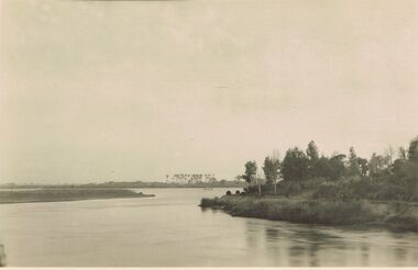 Bendigo Historical Society Inc.
Postcard - ACC LOCK COLLECTION: B&W PHOTO OF A RIVER, EGYPT, POSTCARD, 1914-1918
Poastcard, WW1, B&W photo of one of the river Nile tributaries. Trees on the right side bank and palm trees in the distance beyond a small craft on the river. Handwritten in ink on the back - North of one of the tributaries of the Nile. Egypt Dec '15 Also handwritten in pencil - more of right side to appearpostcard, postcard, ww1, egypt, river nile -
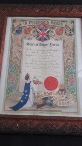 Lilydale RSL Sub Branch
Certificate - Framed Certificate of Thanks and Appreciation, 24/5/1918
Framed Certificate in carved wooden frame headed "In Freedom's Cause"Shire of Upper Yarra ---- The President and Councillors and Ratepayers of the Shire of Upper Yarra Hereby place on record their thanks and Appreciation for the Conduct of Leslie Raymond Jack who served his King and Country in the Great War. In Witness Whereof the Corporate Seal of the Municipality is hereto attached in the presence of. -
 Wodonga & District Historical Society Inc
Album - Hume Reservoir Australia Album - View from the Victorian bank of the Murray River, May 1923, 1927
This set of photos is from a leather bound album bearing the inscription "HUME RESERVOIR AUSTRALIA" plus 'The Rt. Hon. L. C. M. S. Amery, P. C., M .P.' all inscribed in gold. It was presented to The Rt. Hon. L. C. M. S. Amery, P. C., M. P, Secretary of State for Dominion Affairs on the occasion of his visit to the Hume Reservoir on 2nd November 1927. This album is of local and national significance as it documents the planning and development of the Hume Reservoir up to 1927. It was the largest water reservoir in the British Empire. The album records the pioneering engineering work that went into its construction.DEPARTMENT OF PUBLIC WORKS, N.S.W. RIVER MURRAY WATERS SCHEME. HUME RESERVOIR. 12. View from the Victorian bank of the river showing in the foreground a levee bank along the New South Wales side of the river with connecting wings back to the higher ground, May 1923. The first stage in the construction of the Dam foundations was carried out inside the levee bank which was at a sufficient height to protect from floods the work going on inside. A length of 300 feet of the Dam was left at a low elevation to allow of the river flowing over it in the second stage of the operations and at the ends of the concrete was brought up above flood level. To divert the river, a Coffer Dam was built across the old bed above and below the Dam site and tying into the end of the concrete wall built inside the levee bank. This completely surrounded the remainder of the site of the Dam and south wing wall, including an area of 12½ acres.hume reservoir australia, river murray waters scheme, hume reservoir construction -
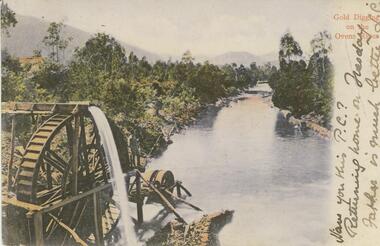 Bendigo Historical Society Inc.
Postcard - GLADYS DEAN COLLECTION: POSTCARD, 1906 - 1908
Coloured photographic postcard with a 2cm white border on right hand side depicting gold digging on the Ovens River. Aspect is taken from behind a waterwheel with a man standing on a platform looking over the river. The banks are thickly treed and mountains can be seen in the distance. The words Gold Digging on the Ovens River are printed in red on the margin and handwritten in black are the words Have you this PC? Returning home on Tuesday Father is much better L.C. On the reverse card is addressed to Miss R Dean 'Esmond" Golden Square Bendigo.44140postcard -
City of Kingston
Photograph - Colour, 29 January 1993
Bonbeach, Carrum and Patterson Lakes are suburbs in the City of Kingston. Bonbeach and Carrum were holiday destinations in early 20th century and over time the housing has converted to permanent residential structures. In Patterson Lakes, the area consists predominantly of newer housing developments and the tidal canal system which is accessible to many dwellings joins Port Phillip Bay.Bonbeach, Carrum and Patterson Lakes were previously part of the extensive Carrum Carrum Swamp. The area was once a source of fish and eels for the Mayone-Bulluk clan of the Bunurong people. Over time the area was drained and this allowed farming at Carrum and Bonbeach, although the area was prone to flooding. In the early 1920s and 30s the land was converted to residential dwellings. In 1973 investigations commenced nearby to Bonbeach and Carrum into the development of a unique residential area comprising canals and waterways. It was originally proposed to be known as "Gladesville". Circa 1974, the area was rezoned from rural to residential and named Patterson Lakes. Development has been continuous since the 1970s with staged construction of the waterways, residential housing, and supporting infrastructure and facilities.Laminated colour aerial photograph of the Bonbeach, Carrum and Patterson Lakes region within City of Kingston. This 1993 image includes Bonbeach High School prior to demolition, Bonbeach Primary School and Patterson River Golf Club. Sections of Patterson Lakes are not yet developed, including Rhode and Staten Islands. Long Island Point appears to be a recent development with many spare blocks and new houses under construction. The Patterson River marina is prominent and the river mouth as it meets Port Phillip Bay. The Carrum railway station is visible.Black type on white adhesive sticker: No. 6661 Black type on white adhesive sticker: 26E/6661, 29/1/93, 4.25 pm Black type on white adhesive sticker 29-1-93 Yellow circular adhesive stickerbonbeach, carrum, patterson lakes, patterson river, carrum carrum swamp, canals and waterways -
 Melbourne Tram Museum
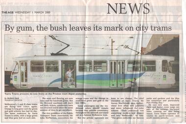
Newspaper, The Age, "By gum, the bush leaves its mark on city trams", 1/03/2000 12:00:00 AM
Newspaper cutting from "The Age Wednesday 1 March 2000, titled "By gum, the bush leaves its mark on city trams" reporting on the new colour scheme for A class trams, which features a gum leaf on the side and Yarra logos. Has a photo of the tram at the Preston tram depot. Quotes John McPherson the vice president of the Public Transport Users Association and Steven McDonald, Chief Executive of Yarra Tramstrams, tramways, colour schemes, livery, yarra trams, preston depot -
 Melbourne Tram Museum
Leisure object - Cardboard Model Tram, Transit Graphics, c2012
Cardboard, punched out, folding model tram - Melbourne D class, 3 section Combino in Yarra Trams livery. Has separate part for pantograph. Has the Yarra trams info on the tram on the base of the model and more information on the card itself. Has a number 3599 on the tram, which is not correct. Produced by Transit Graphics c2012 - no information as on previous similar models as to manufacturer, but in the same style. two copies held.trams, tramways, models, combino, yarra trams, d class -
 Melbourne Tram Museum
Postcard - Cardboard Model Tram Postcard, Siemens, Combino printed for the 100 years of Electric Trams, 2006
Cardboard, punched out, folding model tram - Siemens 3 section Combino printed for the 100 years of Electric Trams in Melbourne, Yarra Trams. with the centenary logo in the top left hand corner. Has assembly notes. Printed as a postcard on the reverse with area for a stamp with 100years trams logo, Yarra tram and Siemens logos. A5 size. Two copies held. See Reg Item 109 for a A4 size.Has a $7 price sticker on the front of the card.trams, tramways, models, siemens, yarra trams, centenary -
 Melbourne Tram Museum
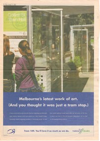
Newspaper, MX News, "Melbourne's last work of art. (And you thought it was just a tram stop.)", 11/10/2002 12:00:00 AM
Newspaper clipping - full page newspaper - from the MX news, Friday 11/10/2002 - titled "Melbourne's last work of art. (And you thought it was just a tram stop.)", featuring stop 6, Collins St, Town Hall - about Yarra Trams Superstops - notes that Yarra trams were awarded the John Truscott Design Foundation award recognising excellence in community designs. Also advertises Route 109.trams, tramways, yarra trams, superstops, collins st, route 109, tram stops -
 Upper Yarra Museum
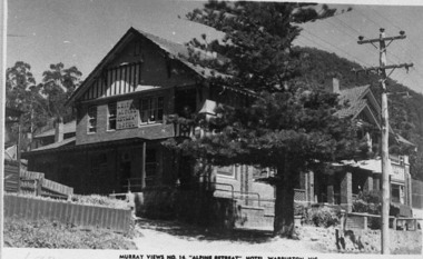
Negative Photographic Reproduction, PC Murray Views 14, Alpine Retreat Hotel Warburton
03053 PC Murray Views 14, Alpine Retreat Hotel Warburton Upper Yarra Shire 1888-1988 Centenary collection. Black & white Negative, scanned at 600 dpialpine retreat hotel warburton pc murray views 14 -
 Eltham District Historical Society Inc
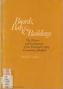
Book, Boards Beds and Buildings: The history and development of the Diamond Valley Community Hospital Greensborough; a community project / Donald Cordner
CONTENTS FOREWORD By Sir Henry Bolte ACKNOWLEDGEMENTS Chapter 1 - The Beginning Chapter 2 - The James Charitable Trust Chapter 3 - The Forming of a Corporation Chapter 4 - Preparation Chapter 5 - The Opening Chapter 6 - The Early Years 1942 - 1950 Chapter 7 - The New Hospital 1950 - 1956 Chapter 8 - Expansion 1956 - 1966 Chapter 9 - Completion 1966 - 1971 Chapter 10 - The Staff Chapter 11 - The Board Chapter 12 - The Medical Profession Chapter 13 - Amenities and Equipment Chapter 14 - The Auxiliaries and Other Contributors Chapter 15 - Patients and Their Treatment Chapter 16 - The Future Appendix I - Board Members 1942- 1971 Appendix II - Hospital Staff 30th June 1971 Appendix III - Office Bearers Of Auxiliaries Digital file only (71 pages and covers) Physical copy held by Yarra plenty Regional Library, Diamond Valley Branch, Civic Drive, Greensborough, Local History Sectiondiamond valley community hospital, greensborough -
Whitehorse Historical Society Inc.
Pamphlet, Chandler-Koonung-Mullum Creeks Sub-Catchment, 1/02/1999 12:00:00 AM
Chandler-Koonung-Mullum Creeks Sub-Catchment Local Action Program, developed by the Chandler-Koonung-Mullum Creeks Sub-catchment Working Group (Lower Yarra Working Group).Chandler-Koonung-Mullum Creeks Sub-Catchment Local Action Program, developed by the Chandler-Koonung-Mullum Creeks Sub-catchment Working Group (Lower Yarra Working Group).Chandler-Koonung-Mullum Creeks Sub-Catchment Local Action Program, developed by the Chandler-Koonung-Mullum Creeks Sub-catchment Working Group (Lower Yarra Working Group).mullum mullum creek, chandler-koonung-mullum creeks sub-catchment working group -
Southern Sherbrooke Historical Society Inc.
Information folder
Information folder pertaining to Birdsland. Contents:/map (copy), Shire of Yarra Ranges, Birdsland Reserve/flyer, Birdsland Then and Now, advertising talk at Belgrave Library, 9 Oct 2014birdsland -
Kew Historical Society Inc
Archive (Sub-series) - Subject File, Depression, 1930s, 1958
Various partiesReference, Research, InformationSecondary Values (KHS Imposed Order)Subject file containing a anonymous, undated article (single page) on the Great Depression in Kew. It might be from Vaughan’s history (1960). It covers Council support and the creation of the Yarra Boulevardgreat depression -- kew (vic.), kew -- history -- 1930s, yarra boulevardgreat depression -- kew (vic.), kew -- history -- 1930s, yarra boulevard -
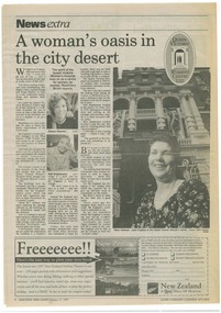 Queen Victoria Women's Centre
Newspaper Excerpt, A woman's oasis in the city desert, 17 February 1997
News paper article. News extra. Melbourne Yarra Leader page 8. Three black and white photographs of women on page. QVWC original logo on top right of page. official events, openings (events), historic buildings -
University of Melbourne, Burnley Campus Archives
Newspaper - Newspaper Cutting, The Leader, Course of Lectures in Villa Gardening, 1903
garden design, c b luffmann, ina higgins, lectures -
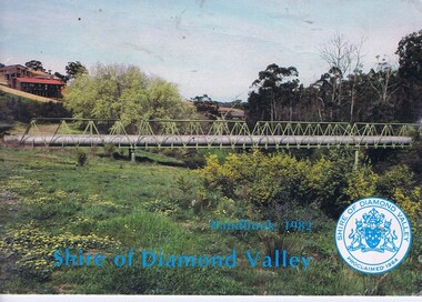 Greensborough Historical Society
Book, The Shire of Diamond Valley Handbook 1982, 1982_
Guide to services provided by Shire of Diamond Valley. The Shire of Diamond Valley was a Local Government Area located about 20 kilometres northeast of Melbourne. The shire covered an area of 74.38 square kilometres and existed from 1964 until 1994.Annual guide to services in Shire of Diamond Valley32 pages, col illus., maps. Cover illustration of aqueduct and bridge over Plenty River near Apollo Parkways estste.shire of diamond valley, greensborough, handbooks -
Glenelg Shire Council Cultural Collection
Negative - Negative -Glenelg River Nelson, Victoria, Miss Zillah Maschmedt, photographer, c. 1936
Negative for a black and white photograph. Image shows view across Glenelg River to Nelson township, bridge in foreground Nelson Victoria. -
Glenelg Shire Council Cultural Collection
Negative - Negative - Donovan's Landing, Glenelg River Nelson, Victoria, c. 1936
Transparency for black and white photo. Donovan's Landing, Glenelg River Nelson Vic. Wooden dinghy in foreground, boat shed on right -
Glenelg Shire Council Cultural Collection
Flyer - Flyers - Portland, Victoria, n.d
Two bi-fold DL flyers, full colour advertising Portland. Lighthouse on Whalers Bluff on front, Glenelg River on back.tourism, advertising, travel -
Ringwood and District Historical Society
Envelope, Packet: Ringwood Area Environment - Land Conservation Council, 150 years of Victoria's Rivers 1989. Heritage Inventory
Historic places, Land Conservation Council relating to past 150 years of Victoria's rivers, streams and water systems; Heritage inventory