Showing 10951 items matching " land"
-
 Stawell Historical Society Inc
Realia, W & J Waters, Stawell Torpedo Bottle
William & John Waters were a Cordial Manufacturing Business William Waters died in 1870 and was buried in Stawell. Factory and Land in Frayne Street Stawell Found at Stawell Butter FactoryGreen Torpedo Shaped Bottle with broken neck K & J Waters Stawellmanufacturing -
 Whitehorse Historical Society Inc.
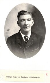
Photograph - Black and white photograph, George Augustus Goodwin
George Goodwin was born in England in 1869 married Annie Edwards in Australia and had 11 children. 1877 bought land in Blackburn. The house was called Weston Favell and changed to Greenways.Portrait photograph of George Goodwin in a suit and tie with tie pin.george goodwin, blackburn -
 The Beechworth Burke Museum Research Collection
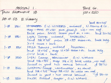
Card (Series) - Index Card, George Tibbits, Ford Street, Beechworth, 1976
George Tibbits, University of Melbourne. Faculty of Architecture, Building and Town & Regional PlanningIndex system that support the research for Beechworth : historical reconstruction / [by] George Tibbits ... [et al]Arranged by street names of BeechworthEach index card includes: street name and number of property, image of property, allotment and section number, property owners and dates of ownership, description of the property according to rate records, property floor plan with dimensions.beechworth, george tibbitsbeechworth, george tibbits -
 Eltham District Historical Society Inc
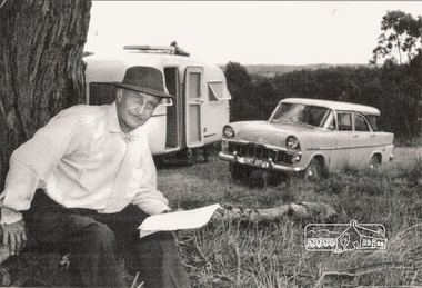
Photograph, Alan Marshall with his Sunliner caravan at Research, Vic, c.1962
Author Alan Marshall lived at Eltham from 1955 to about 1981. Alan owned land at Research and often lived there in his caravan while he was writing. A story about this land is told by John Morrison in "The Writer and the Swagman", which appears in his book "Australian by Choice." Local people also remember Alan living in his caravan beside an old house occupied by his friend, artist Neil Douglas, which was situated on the site of the present-day Eltham College oval and owned by the Pelling family at that time. It is understood that the land owned by Alan Marshall was nearby in Cassells Road. Vivienne Turner of Eltham recalled that her family had a photo of Alan and his caravan at Research and a copy was provided to EDHS in 2003. The caravan was a Sunliner model. See EDHS Newsletter No 151 July 2003Black and white photograph, injet print on paper alan marshall, caravan, research (vic.), eltham college, neil douglas, pelling family, turner family, sunliner caravan, ek holden special station sedan, cars, 1962 -
 Bayside Gallery - Bayside City Council Art & Heritage Collection
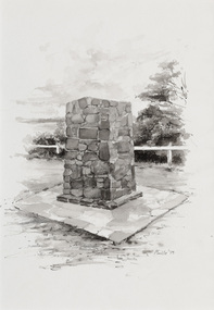
Work on paper - ink and watercolour, Annette Meikle, Moysey Memorial, 1977
In 1977, artist Annette Meikle undertook a commission to illustrate a book recording stories of places and people in the Bayside area. It was published in 1978 as Sandringham Sketchbook, with text by Elizabeth Waters. The sketches were intended to record remaining examples of Bayside’s early architecture and environment, as well as reflect newer architectural changes. Meikle went on to donate 22 of these sketches to Bayside City Council in 2003. Erected in 1964, this stone cairn on Beach Road in Beaumaris marks the site of the wattle and daub cottage of James and Susannah Moysey. James, Susannah and their cousin Nicholas arrived in Victoria in 1844 and leased land on the cliff-top. They built a cottage, cleared the land for sheep and cattle and established vegetable gardens. They later purchased the land and named it Beaumaris Park, derived from the name of the Welsh coastal resort where Edward I built Beau Marais castle.Annette Meikle, Moysey Memorial 1977, ink and watercolour, 35 x 23.5 cm. Bayside City Council Art and Heritage Collection. Donated by the artist, 2003annette meikle, sandringham sketchbook, elizabeth waters, port phillip bay, moysey memorial, coastline, stone cairn, james and susannah moysey, beaumaris -
 The Beechworth Burke Museum Research Collection
Card (Series) - Index Card, George Tibbits, 9 Bridge Street, Beechworth, 1976
George Tibbits, University of Melbourne. Faculty of Architecture, Building and Town & Regional PlanningIndex system that support the research for Beechworth : historical reconstruction / [by] George Tibbits ... [et al]Arranged by street names of BeechworthEach index card includes: street name and number of property, image of property, allotment and section number, property owners and dates of ownership, description of the property according to rate records, property floor plan with dimensions.beechworth, george tibbitsbeechworth, george tibbits -
 Flagstaff Hill Maritime Museum and Village
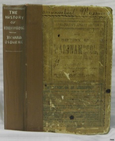
Book - Historical, Warrnambool, Richard Osburne, The History of Warrnambool, 1887
This little book is one of only 1000 books published of the original Queen's Jubilee Edition. It spans fifty years of the history of Warrnambool from the time that the first Government Land Sales commenced. It also deliberately coincides with the 1887 celebrations of Queen Victoria's Jubilee Year of her ascension to the British Throne. The book is an invaluable reference for researchers of local Warrnambool history and has been used as a textbook and reference book for local students. The book became part of the Warrnambool Public Library, and when the library closed down, the book was held by the Warrnambool City Council until, in 1974, it was transferred to the newly established Flagstaff Hill Maritime Museum and Village. The author, Richard Osburne, (1825-1895) was born in Australia. He moved to Warrnambool in 1847 as the first local Journalist. In 1851 he founded the Warrnambool Examiner newspaper which he operated until the end of 1880. Osburne was much involved in civic and community affairs of the town, and he set himself the task of recording the history of the city's early pioneers. In the introductory pages of the book the author refers to himself as "The Father of the Warrnambool Press". Only 1,000 copies of this edition of the book were printed. In September 1980 a facsimile edition was printed with the addition of illustrations from the period, an index and relevant annotations by local historian T.A. Wicking (Tom Wicking). This later book was named the Premier Town Edition, due to Warrnambool being awarded the title of Premier Town in Victoria in 1979-82 by the Premier of Victoria; it also received the inaugural award in 1959 and a later award in 1988-91.This book is rare. It is one of only 1000 copies printed, and one of three in the Collection of Flagstaff Hill Maritime Museum and Village. The book was dedicated to the early colonists as well as to the new arrivals by the writer, Richard Osburne, who entitles himself as "The father of the Warrnambool Press". The content of the book is invaluable as a reference for Warrnambool and District's local history in its early colonial and pioneering days. It provides the information that helps in an understanding the foundation that the city was built on, connecting the people of today to the pioneers of the past.The History of Warrnambool: Capital of the Western Ports of Victoria, From1847 up to the end of 1886 (when the first Government Land Sales took place) Author: Richard Osburne, "Proprietor of the Warrnambool Examiner from 1851 to the close of 1880" Publisher: The Chronicle Printing and Publishing Company Limited Date: 1887 (MDCCCLXXXVII) (Roman numerals are covered in tape) Edition: Original: Queen's Jubilee Edition Hardcover book with titles on the spine and front cover. The front and back covers have been coated in a clear substance, the spine has fabric reinforcing with titles handwritten in white. Inscriptions include stamps and handwriting. A library label has been pasted onto the front cover, then the cover has been lacquered. The first fly page has a message to the readers, as shown in the Inscriptions of this record. Many of the pages in this book have handwritten notes in the margins and within the text and some of the lines are crossed out.The Pastedown front endpaper has a sticker from Warrnambool Mechanics Institute and Free Library Front loose endpaper has a stamp from "Warrnambool Mechanics Institute" Handwritten Iin black pen on from cover are the words "Warrnambool Museum" Label on the front cover: "THE ATTENTION OF SUBSCRIBERS ..."warrnambool, shipwreck coast, flagstaff hill, maritime museum, maritime village, the history of warrnambool, richard osburne, osturne's history of warrnambool, queen's jubilee edition, 1847-1887, warrnambool history, the chronicle printing and publishing company, capital of the western ports of victoria, first government land sales, warrnambool examiner, five shillings, warrnambool's first reporter, warrnambool public library, 1887, 1979, premier town, premier edition, queen's jubliee, queen victoria's jubilee, western ports of victoria, 1847, government land sales, chronicle publishing and printing co., 1000 copies, old colonists, young australians, new arrivals, rise and progress, capital of western victoria, interesting and useful, the father of the warrnambool press -
 Eltham District Historical Society Inc
Slide - Photograph, Birch Cottage, Yarra Glen Road, Christmas Hills, c.Mar. 1989
Historical property that sits beside Watsons Creek. In 1903 a Miners Right of one acre in area was granted to Edwin Samuel Birch. In 1907 Birch applied to purchase this land but was unable to because it was part of the creek reserve. The house existed at that time. Birch died in 1932 and his daughter Honor Mary Birch was granted a permit to occupy the residence. The future of the cottage remains precarious because of its location on Crown land. In 2007 the Andrew Ross Museum began a campaign to ensure its preservation - NL18235mm colour positive transparency (1 of 28) Mount - Kodak KodachromeProcess Date MAR 89Mbirch cottage, christmas hills, smiths gully, watson's creek, yarra glen road -
 St Kilda Historical Society
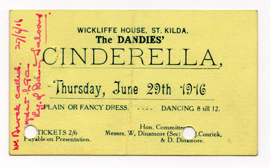
Ephemera - Ticket, The Dandies' Cinderella, 1916
For Cinderella dance at the Dandies' at Wickliffe House St Kilda. Wickcliffe House was an elaborate wedding cake of a house, built in 1873 on one of the prime pieces of land in St Kilda overlooking the bay. In 1912 it was converted to cafe and theatre called Arcadia and subsequently The Dandies open Air Theatre. It was demolished in.the 1970's and the land is now occupied by Arrandale, one of the last high rises to be built along the foreshore. Wickliffe was built for John Dickson Wyelaskie who was a higly successful parstoralist in the Western District. Yellow cardboard printed one side in dark blueHandwritten notation in red ink, mostly illegible, dated 27/6/16 wickliffe house, the dandies -
 Sunbury Family History and Heritage Society Inc.
Photograph, Clarke Oval
The Sunbury Football Club, known as 'The Swifts' was formed in 1897 and the early matches were probably played on Munro's which was a stretch of land bounded by Evans, Barkly, O'Shanassy and Shields Streets. Later land adjacent to the railway line, now Sunbury Shopping Centre was where football was played until Clark Oval was opened in 1953. Since then it has been the town's main sporting venue and the site for the annual show and other events. In this photograph the football match is being played on the Clark Oval with the clubrooms visible in the background. The Sunbury Football Club is one of a number of sports clubs established vin Sunbury.A non-digital black and white photograph of a football match being played on an oval. The clubrooms are visible in the distance.sunbury football club, clark oval, "the swifts' -
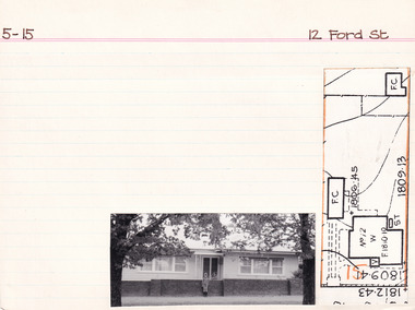 The Beechworth Burke Museum Research Collection
Card (Series) - Index Card, George Tibbits, 12 Ford Street, Beechworth, 1976
George Tibbits, University of Melbourne. Faculty of Architecture, Building and Town & Regional PlanningIndex system that support the research for Beechworth : historical reconstruction / [by] George Tibbits ... [et al]Arranged by street names of BeechworthEach index card includes: street name and number of property, image of property, allotment and section number, property owners and dates of ownership, description of the property according to rate records, property floor plan with dimensions.beechworth, george tibbitsbeechworth, george tibbits -
 Orbost & District Historical Society
Book - front cover, The Corringle Creek to Sydenham Inlet Coastal Reserve A RESOURCES STUDY, 1977
This 1977 Resources Study was a joint project of the Shire of Orbost & the Dept. of Crown Lands & Survey with the purpose of collating information on natural resources, pattern of public use, and constraints on future use so that management can be formulated.This report gives and understanding of the resources and management directions of coastal land in East Gippsland in 1977. A buff coloured cover with black printing and blue tape binding. 71 pages + maps/charts. THE CORRINGLE CREEK TO SYDENHAM INLET COASTAL RESERVE. A resources study with comment on the implications for management by IAN R. BROWN Research officer and PETER B. LAVERY Land Management Oficer. Coastal management Committee Victoria 1977. Published under the authority of the Coastal Management Committee by the Department of Crown Lands and Survey, Victoria 1977. Printed by James Yeates Printing, Bairnsdale 3875.corringle creek, sydenham inlet, natural resources survey -
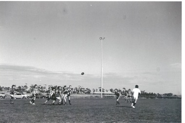
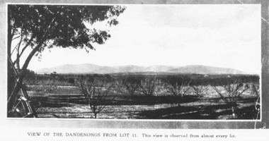 Ringwood and District Historical Society
Photograph, Mullers orchard, Heathmont. Looking east from cnr. Canterbury and Dickasons Rds. "Charm View Estate" - 1926
Printed below photograph, "View of the Dandenongs from Lot 11. This view is observed from almost every lot". Written on back of a photograph, "Photo taken from sub. div. plan land sales. Charm View Estate, Heathmont, 1926?" Another copy reads, "Mullers orchard, Heathmont. Taken from cnr. Canterbury and Dickasons Rds. Looking east - 1926". -
 Ringwood and District Historical Society
Map, Plan of Country Lands in the Parishes of Nunawading Ringwood and Scoresby - circa 1855
Blueprint copy of Survey Map detailing original Selectors' names and property locations. List of Parish map references including property bearings, distances in Links, and markings on trees. Descriptive remarks include areas marked "Farmer's Common", "Poor soil thickly/moderately timbered with stringy bark", and location of water and firewood reserves."Surveyed and plotted by N.M. Bickford, Superintendant of Mr. Hodgkinson's Field Party". "The land comprised in this survey is of inferior quality, moderately undulating, and thickly wooded. It is watered by Dandenong Creek and Deep Creek." Inset map showing location of (*proposed) cemetery on southern corner of Lillydale Road from Melbourne and Sawmill Road, later Mount Dandenong Road. (*Cemetery did not eventuate.) -
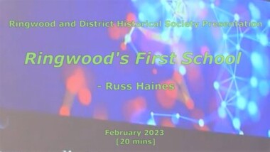 Ringwood and District Historical Society
Mixed media - Video, RDHS Meeting Presentation - "Ringwood's First School" - Russ Haines
Digitised video (894MB). Duration: 20 minutes. Recorded February, 2023 (Video is available for viewing at Ringwood & District Historical Society Archives by appointment)As a follow up to the recent centenary celebrations of the 1921 Ringwood State School building in Greenwood Avenue, Ringwood and District Historical Society President Russ Haines presents this look back at the often overlooked earlier history of the village of Ringwood, including the establishment of Cass' School in 1874 on five acres of land between Dublin Road and Everard Road, becoming Ringwood's first school. -
 Rutherglen Historical Society
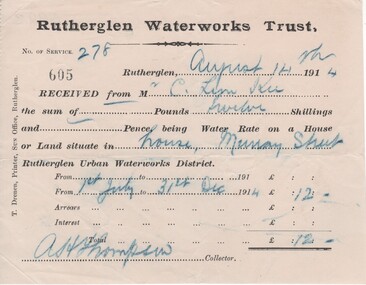
Financial record - Receipt, T. Drenen, 14/8/1914 (Exact)
It is believed that the C. Lim Kee who was paying these rates was Charles Lim Kee. According to the Rutherglen Sun September 11, 1896 he was starting a business known as the Cash Bakery in premises previously occupied by Conrad Huhs. In 1903 he moved to new premises next to the Bank of Victoria. By 1908 he had a shop and rooms in Main Street, and houses in Wallace Street and Murray Street. Part of a collection of business documents found under the floor of a building in Main Street when it was being renovated. At that time the owner was Don Chambers, and the premises was occupied as the Chambers Riteway Supermarket. The location (134 Main Street) is currently (2022) occupied by Miegel’s Pharmacy Rutherglen. Receipt from Rutherglen Waterworks Trust for water rates for a house in Murray Street. The form is printed on paper with hand written details reproduced with carbon paper.,"Rutherglen Waterworks Trust, No. of service 278. [receipt no.]: 605. Rutherglen, August 14th 1914. Received from Mr C. Lim Kee the sum of --- Pounds twelve Shillings and --- Pence, being Water Rate on a House or Land situate in house, Murray Street Rutherglen Urban Waterworks District. From 1st July to 31st Dec 1914." Signed A.H. Thompson, Collector.lim kee, rutherglen waterworks trust, water rates, business documents, 134 main street, chambers riteway supermarket -
 Mt Dandenong & District Historical Society Inc.
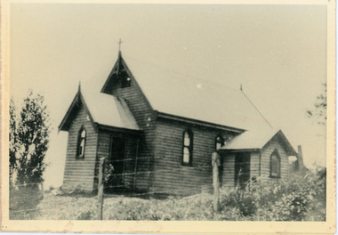
Photograph, Church of England, Olinda
Church of England. Monash Avenue, Olinda. The descriptive text on the reverse of this photograph was hand written by John Lundy-Clarke.Church of England Olinda When the church was built it faced on to the main Mt Dandenong Road but the road was deviated in and the main road section in front of the Village Settlement blocks was named Monash Avenue. The chapel built on Mrs Warner’s land on Mernda Road (later Coonara Road) was shifted in 1936 by Dick Mitlan using Jack Clarkes Ford truck as traction plant. church of england, olinda, monash avenue -
 Orbost & District Historical Society
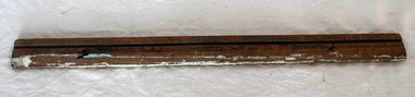
ruler, C 1930's
The Mundy family were farmers / settlers in the Snowy River area since c. 1880s. The original Mundy family moved to a land "selection" at Betebolong in the early 1880's from Buchan. John Mundy grew up in the Orbost district. This item highlights the comparison between today's educational equipment and those of the 1930's.A 15 inch wooden ruler with carvings and holes.On back - J. MUNDYmeasurement ruler mundy-family educational -
 Eltham District Historical Society Inc
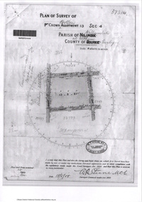
Document - Photocopy, Survey Fleld Notes of Part of Crown Portion 13, Section 4 at Eltham, Parish of Nillumbik, County of Evelyn, 18 May 1908
Portion of land bounded by: Main Road, Luck Street, Bible Street, Arthur Street Application 37314 W. P. Steane, M.C.E. Civil Engineer and Surveyor, 18 May 1908application 37314, arthur street, bible street, eltham, luck street, main road, map, survey plan -
Glen Eira Historical Society
Letter - Tucker Road, 197, Bentleigh
Copy of letter dated 03/02/1977 by sworn valuator to Charles Latham regarding land purchase at rear of 197 St. James Avenue. Also includes hand drawn plan.latham charles, st. james avenue, scott w.v., land values, local government, houses, home units, tucker road, bentleigh -
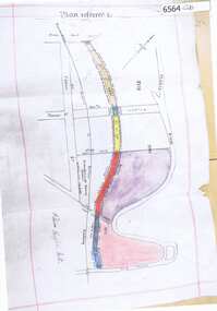 Greensborough Historical Society
Map, Poulter Avenue transverse, 1900 c
This is a survey of land acquired from William Haylock Poulter for the construction of Poulter Avenue. Includes area of River Estate and part of Poulter Reserve, Carter Street, Flintoff Street and Plenty River.1 p. photocopy of traverse survey printed in colourSigned by William Haylock Poulterpoutlter avenue greensborough -
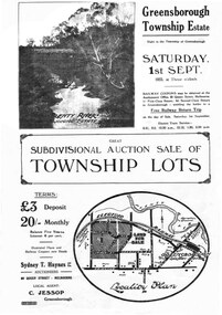 Greensborough Historical Society
Plan - Digital Image, Greensborough Township Estate, 01/09/1923
Sub-division into 129 lots of land belonging to the Scotland Family, bounded by William Street, Eliza Street, James (Jessop) Street and south of Lorimer Street. Auction 1 September 1923Digital copy of plan. Has been digitally corrected from damaged original.subdivision plans, greensborough township estate, scotland family -
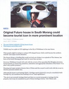 Greensborough Historical Society
Newspaper Clipping - Digital Image, The Whittlesea Post, Futuro House Greensborough, 2017, 02/07/2017
Written in 2017, this article reports on the history of the Futuro House, now in South Morang, but previously used in Greensborough as a temporary booth for sales of land at a new housing estate called Apollo Parkways.Digital copy of newspaper clipping, black text and colour image.futuro house, apollo parkways -
 Greensborough Historical Society
Newspaper Clipping, Diamond Valley Leader, Club tees to another five years, 12/06/2018
Strathallan Golf Club has holed out on the 18th, securing a five year lease for its golf course just months before it would have been kicked off the land.News article 1 page, black text.strathallan golf club, latrobe university -
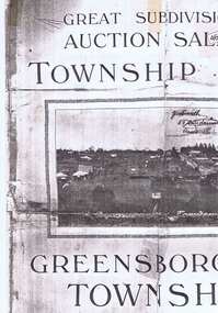 Greensborough Historical Society
Plan, Greensborough Township Estate, 01/09/1923
Sub-division into 129 lots of land belonging to the Scotland Family, bounded by William Street, Eliza Street, James (Jessop) Street and south of Lorimer Street. Auction 1 September 1923Photocopy, double-sidedsubdivision plans, greensborough township estate, scotland family -
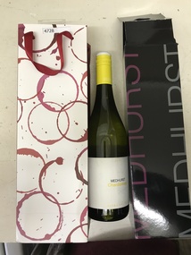 Greensborough Historical Society
Bottle and Apron, Primary Edge Promotions, Medhurst Bottle and Apron, 2016_
Medhurst Wines operates in Gruyere, Yarra Valley. The winery is on land once owned by David Medhurst, formerly of Greensborough. These items were a gift to David's descendant, Faye Fort (nee Partington).Clear glass wine bottle 750 ml, screw cap, in black cardboard presentation box in red and white gift bagLabelled Medhurst Chardonnay 2016 Yarra Valley; with, black poly cotton apron, with pocket, embroidered Medhurst in white.medhurst family, medhurst wines yarra valley -
 Greensborough Historical Society
Maps, Greensborough west of Plenty River, 1840o
Areas of Greensborough, west of the Plenty River, showing land holdings in the 1840s. Comprises Sections 8, 9, 10, 14, 15, 16, 17, 18, 19, 20 Parish of KeelbundoraOne A4 photocopy, one A3 enlargementgreensborough, watsonia, lower plenty, janefield -
Glenelg Shire Council Cultural Collection
Pamphlet - Brochure, Steam Packet Inn, n.d
The Steam Packet Inn is the second oldest building in Portland. It was licensed to an ex convict from Van Diemens Land (Tasmania) in 1841. Later became a police barracks. It is a heritage listed buildingYellow card, tri-fold brochure, containing history of Steam Packet Inn, Bentinck St. Portland. Photo of steam Packet Inn on front of brochure, floor plans on the back.steam packet inn, bentinck street, portland -
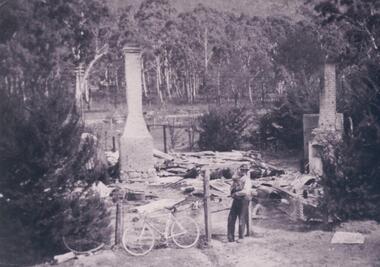 Halls Gap & Grampians Historical Society
Photograph - B/W
Jack and Amy McKeon's house burnt out remains, their house was set back from the what is now called Grampians Rd, on land between Grand Canyon Motel And Tim's Place.Site of burnt out residence. Two brick chimneys and a tank remain standing. Two fir trees in foreground on the fence line. Man holding a dog near post of the gate and bicycle lean against the wire fence . A road and power lines cross the picture beyond the site,backed by gum trees.buildings, houses