Showing 11121 items
matching planning
-
 Bialik College
Plan (item) - Site development proposals, Shakespeare Grove, 1986
Site development proposals for 6 Shakespeare Grove, Hawthorn, as part of the Bialik College Strategy Plan, created by Jennings Project Management, October 1986. Includes plan of existing land use and site constraints. Please contact [email protected] to request access to this record.1980s, building and planning -
 Ringwood and District Historical Society
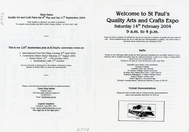
Pamphlet, St. Paul's Quality Arts and Crafts Expo - Ringwood - 2004, 14-Feb-04
Quality Arts and Crafts Expo part of the celebrations at St. Paul's Church, Ringwood on the 125th. Anniversary of the Church. Other events were International Food Fair, April, Celebratory Dinner Dance August, Flower Show October, and Archbishops Visit October.Black and white A4 bifold pamphlet with black printing and B&W sketch of Church on lower front. Plan of stalls on p3. Printing on all pages +Additional Keywords: Carter, Richard -
 Ringwood and District Historical Society
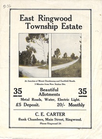
Flyer, Subdivisional Land Sale Brochure, East Ringwood Township Estate, Vic. - 1923
Bi-folded double sided land subdivision sale advertisement with location map and summary of local facilities and services. Includes two additional images of allotment plan with subsequent handwritten notations.Subdivision includes Mount Dandenong Road, Grey Street, and Eastfield Road. Agent - C.E. Carter, Bank Chambers, Main Street, Ringwood. Phone Ringwood 24. -
4th/19th Prince of Wales's Light Horse Regiment Unit History Room
Booklet, Australian Army Manual of Land Warfare Part 2 Vol 1 Pam No 1 Employment of Artillery (All Corps) 1984, 1984
A soft covered booklet describing the role and general principles of field artillery, its equipment and effects, command and communications administration and supply, planning and employment, air defence etc. 2 copies7610-66-118-5456artillery, employment -
 Federation University Historical Collection
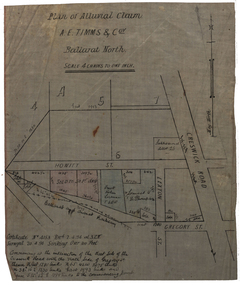
Plan, Plan of Alluvial Claim of A.E. Timms and Co, 1894, 02/04/1894
This item was removed from Catalogue Number 3601Plan of a lease located near Cresick Road. Scale: 4 chains to 1 inch (1:3168) WGS 84 37 32 35 South 143 50 50 Easttimms, a.e. timms & co., howitt st, ballarat north, creswick road, alluvial claim, mining -
 Federation University Historical Collection
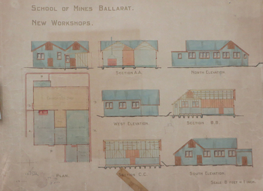
Plan, Ballarat School of Mines New Workshops, 1912, 08/1912
Original plan for new workshops for the Ballarat School of Mines. Includes elevations and sections, abd has been coloured with watercolour. The new workshops housed carpenters shop, plumbers, blacksmihing and stores. ballarat school of mines, new workshops, carpentry, blacksmithing, plumbing, architectural plan, laboratory -
 Federation University Historical Collection
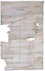
Plan, South Dividend Quartz Mining Company Plan
A hand drawn and coloured plan showing the position of the following gold mines in Steiglitz - South Dividend Company, the Marquis of Lorne Company, New Year's Reef, Malekoff Company and the Brazilian Reef.steiglitz, south dividend company, marquis of lorne company, new year's reef, malekoff company, brazilian reef, t. woolgrove -
 Bendigo Historical Society Inc.
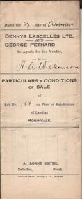
Document - H.A. & S.R. WILKINSON COLLECTIONCONDITION OF SALE
Particulars & conditions of sale of lot no. 188 on plan of subdivision of land at Robinvale between Dennys Lascelles Ltd + George Pethard as agents for the vendor and H. A. Wilkinson (buyer). Price 63 pounds.organization, business, h.a. & s.r wilkinson real estate -
Bendigo Historical Society Inc.
Map - CAMPBELL COLLECTION: BENDIGO AND DISTRICT MAPS
Map. Ellesmere, Parish of Ellesmere. Scale 20 chains to 1 inch. Total area 3926 acres. Prepared in W.P.B. from A and P plans. (number 354 in map cupboard 1)map, bendigo, agricultural lands -
 Bendigo Historical Society Inc.
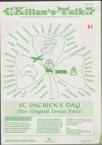
Document - WES HARRY COLLECTION: KILLIAN'S TALK, ISSUE TO PROMOTE ST PATRICK'S DAY 17 MARCH 1993, COST ONE DOLLAR
A4 isssue of Killian's Talk, incorportaing Bendigo Irish Associations Newsletter, issue details the activities planned to celebrate St Patrick's Day 17 March 1993. Loose leaf iisueThe TERRACE Print Service, 133 McCrae Street, Bendigo -
 Bendigo Historical Society Inc.
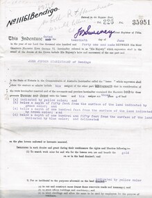
Document - MCCOLL, RANKIN AND STANISTREET COLLECTION: EAST CLARENCE GOLD MINING CO - LEASE 11161, 1941
Document; East Clarence Gold Mining Co - Lease 11161. Lease document for Crown Land No. 11161 Bendigo. Includes plan of lease area Whipstick Road Eaglehawk. No. 11161 Bendigo.MCCOLL RANKIN & STANISTREETorganization, business, gold mining lease, mccoll rankin & stanistreet -
 Bendigo Historical Society Inc.
Document - BILL ASHMAN COLLECTION: CORRESPONDENCE
Two plans of Gifford's Mt Gambier Hotel (one has typed capacities, the other hand written) and one page of typed Particulars of Mr. Gifford's Hotel Boiler for Hot Water.sciences, instruments - general, scalebuoy, bill ashman collection - correspondence, gifford's mt gambier hotel -
Port Melbourne Historical & Preservation Society
Plan, Department of Lands and Survey, The Township of Sandridge, 25 Nov 1860
Plan of the township of Sandridge lithographed at the department of Lands and Survey, Melbourne 5th November, 1860. Identical to 1859 version except for added rail line through Sandridge and onto Town Pierengineering - roads streets lanes and footpaths, municipal district of sandridge -
 Port Melbourne Historical & Preservation Society
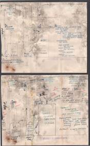
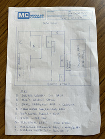
Document, MM Crane Factory - Plan View, 18 Feb 2020
Blue printed plan view of Malcolm Moore Crane Factory with lettered index of areas within the factory from 1979 some with names listed including Norm (presumably Norm Robinson).built environment - industrial, industry, engineering, malcolm moore pty ltd, norm robinson -
 Bendigo Historical Society Inc.
Document - MCCOLL, RANKIN AND STANISTREET COLLECTION: INDENTURE NO. 10834 BENDIGO, 1936
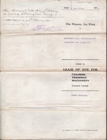
Document: Monument Hill consolidated (Bendigo) N/L. 10834 lease of site for machinery 2/6/1936. Plan included. A. Phillips------- 4/25207. Signature Asst. Registrar of titles.MCCOLL RANKIN & STANISTREETorganization, business, gold mining lease, mccoll rankin & stanistreet -
 Bendigo Historical Society Inc.
Document - MCCOLL, RANKIN AND STANISTREET COLLECTION: GREAT SOUTHERN EXTENDED, 1934
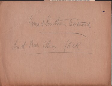
Documents: folder contains - plan of area applied for on Lease No. 10486 - 1934, 1933 application for mining lease, 1934 application for mining lease. Great Southern Extended and South New Chum.MCCOLL RANKIN AND STANSISTREETorganization, business, gold mining - legal, mccoll rankin and stansistreet, great southern extended, new chum line. -
 Bendigo Historical Society Inc.
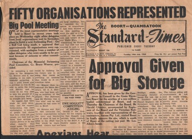
Newspaper - HARRY BIGGS COLLECTION: HISTORY OF BOORT & DISTRICT, 1964
Newspaper. Harry Biggs Collection. Old newspaper cuttings relating to the history of Boort and district, including the formation of the Boort Historical Society. Contributions being sought for planned book on the history of Boort.newspaper, harry biggs collection, boort, boort historical society -
 Bendigo Historical Society Inc.
Map - JACK FLYNN COLLECTION: HUNTLY, 12.03.1932
Map: Township of Huntly, Parish of Huntly , County of Bendigo. Parish plan. Western and South Riding Division on Main St. (Main Northern Highway) - written in ink below name of map.BY Authority H.J. Green. Photo-Lithographed at the Dept., of Lands and Survey, Melbourne. 12.3.32map, bendigo, township, huntly -
NMIT (Northern Melbourne Institute of TAFE)
Report: Campuses, buildings and rooms - Layouts and listings July 1994 NMCOT
Spiral bound report of 284 pages, A4 size. Consists mainly of campus location maps and room layout plans by building. Prepared by Neville Lester for Northern Metropolitan College of TAFE.northern metropolitan college of tafe, buildings, reports, nmit -
Bendigo Historical Society Inc.
Map - HUNTLY, SHEET 4, 29/03/1876
Map: Parish of Huntly, Sheet 4, County of Bendigo. Hand Draughted Parish plan. Originally in Map Cupboard. Relocated to Map Drawer 5 on 22.9.22. Too long for the map cupboard.map, bendigo, parish plan, huntly -
Bendigo Historical Society Inc.
Map - PLAN OF THE BENDIGO RAILWAY YARD, Circa 1960
Map: Plan of the Bendigo Railway Yards, Scale: 80 feet to 1 inch. 1960's. (number 319 in map cupboard 1) Location unknown. Image in Mosaic images overflow.map, bendigo, railway yard, railways, rail yards, station layout -
Whitehorse Historical Society Inc.
Pamphlet, Blackburn bellbird area, 1986
Pamphlet on proposal to extend planning controls over buildings, subdivision and tree removal introduced in 1985.Pamphlet on proposal to extend planning controls over buildings, subdivision and tree removal introduced in 1985. Now these controls are proposed to extend over a further 53 streets in Blackburn's 'Bellbird Area'.Pamphlet on proposal to extend planning controls over buildings, subdivision and tree removal introduced in 1985. town planning, victoria. department of planning and environment, blackburn -
 Whitehorse Historical Society Inc.
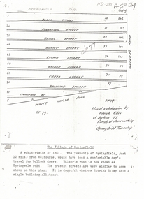
Document, Plan of Subdivision, 1861
Copy of plan of subdivision by Patrick RileyCopy of plan of subdivision by Patrick Riley of Section 77, Parish of Nunawading 'Springfield Township' 1861. Bounded by Whitehorse Road, Walker's Road, (now known as Springvale Road) and Springfield RoadCopy of plan of subdivision by Patrick Rileyland sales, riley, patrick, whitehorse road, nunawading, walkers road, springfield road, black street, robertson street, sandy street, burnt street, luckie street, bridge street, creek street, koonung street, thompson street -
Whitehorse Historical Society Inc.
Article, Group's reunion, 1992
Planned reunion for Nunawading's 'Love thy neighbour' group which met regular;y for more than 17 years. The group was started by Vi Gillin in 1972. With photo from 1976.community groups, love thy neighbour, gillin, vi, kuhn, joan, mount pleasant uniting church -
 Whitehorse Historical Society Inc.
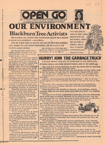
Newspaper, Open Go, 1/12/1976 12:00:00 AM
Periodical published under the Australian Assistance Plan and edited by Morna Sturrock, includes material on use of land next to Blackburn Lake, Koonung Mullum Forestway and along the route of the Eastern Freewayenviroment, blackburn & district tree preservation society, mullum mullem creek, koonung mullum forestry association, eastern freeway -
 Whitehorse Historical Society Inc.
Article, Green dream for shops
The Burwood brickworks site in Middleborough Road may become the world's first retail centre with a living building accreditation. There are plans for a 10,500 sq. m. shopping centre and 750 townhouses and apartments.brickworks, retail trade, middleborough road, environment -
 Whitehorse Historical Society Inc.
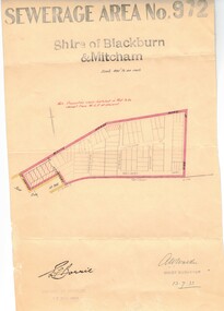
Document, Sewerage area, 13/07/1933 12:00:00 AM
Plan of sewerage area no. 972, Shire of Blackburn and Mitcham, scale 400' to an inch. 13 July 1933. Note that the area including Stuart Street on the map is now the Thiele Court area.sewerage and sanitation, shire of blackburn and mitcham, whitehorse road, blackburn, railway road, vine street, lithgow avenue, downing street, frankston street, stuart street, thiele court -
 Whitehorse Historical Society Inc.
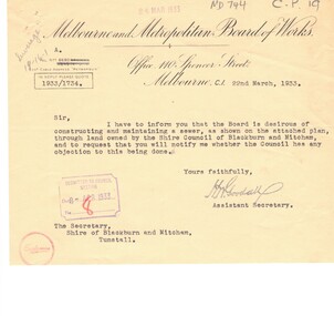
Document, Sewerage, 1933
Plan of M.M.B.W. reticulation area no 708,Shire of Blackburn and Mitcham; sewer through council property.Plan of M.M.B.W. reticulation area no 708,Shire of Blackburn and Mitcham; sewer through council property. Scale 40' to 1' [1933?] with correspondence between MMBW and the Shire, March - April 1933.Plan of M.M.B.W. reticulation area no 708,Shire of Blackburn and Mitcham; sewer through council property.sewerage and sanitation, melbourne and metropolitan board of works, shire of blackburn and mitcham, pope road, blackburn, whitehorse road -
 Brimbank City Council
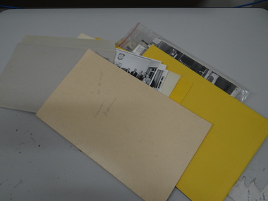
Manilla Folder
Manilla folder with a number of various sizes envelopes containing black and white phots form around mid 20th century of councillors, residents, street. Aslo number of urban plans and maps. -
 Bendigo Historical Society Inc.
Document - MARKS COLLECTION: REPORT ACCOMPANYING PLAN ON THE BALLERSTEDT & SONS MINE, VICTORIA HILL
Handwritten two page document. On top of document: Report accompanying plan on the underground working in Messrs Ballerstedt & sons ( indecipherable word ) mine, Victoria Hill. This document refers to item 8300.bendigo, mining, ballerstedt & son mine