Showing 11442 items
matching maps
-
 Ringwood and District Historical Society
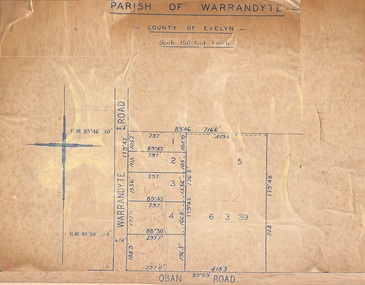
Map, Subdivision Plan of 5 residential allotments on Warrandyte Road and Oban Road, Ringwood, Victoria - (Undated - pre 1950s)
Partial copy of Crown Allotment Map on cardboard backingParish of Warrandyte, County of Evelyn. -
 Canterbury History Group
Document - A Victorian Gem - Heritage Report "Arklow"
Heritage Report for "Arklow", 40 Bryson Street, Canterbury - part of Arklow Hill Estate. Report includes information on submission and previous owner Title information11 pages, spinal bound, A4, includes mapsarklow hill estate, heritage studies, bryson street, victorian style -
 Bendigo Historical Society Inc.
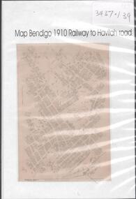
Map - MAP BENDIGO, 1910
DVD. Map of Bendigo 1910 Railway to Havilah Road. -
 Greensborough Historical Society
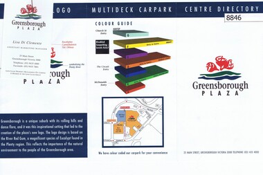
Pamphlet, Greensborough Plaza Centre Directory, 1994c
Directory of shops in Greensborough Plaza about 19941 page printed on both sides, colour mapsgreensborough plaza, directories, shopping centres -
 Greensborough Historical Society
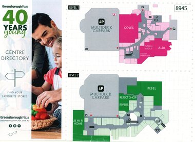
Pamphlet, Greensborough Plaza Centre Directory 40 years young, 2018
Directory of shops in Greensborough Plaza issued for the 40 years anniversary in 20181 page printed on both sides, colour mapsgreensborough plaza, shopping centres -
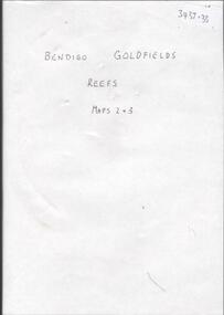 Bendigo Historical Society Inc.
Map - BENDIGO GOLDFIELDS REEFS. MAPS 2 & 3
DVD. Bendigo Goldfields Reefs, Maps 2 & 3. -
4th/19th Prince of Wales's Light Horse Regiment Unit History Room
Badge, Remembrance Day 1918, 1918
Produced for sale for Remembrance Day 1918A plastic covered paper badge. It is a a shield shape and has a map of Australia in gold surmounted by a red crown. Under the map is a blue ribbon with the word Australia in white. There is a laurel either side of the map in green with a yellow scroll under with 'Heroes, Gallipoli" under with April 25th 1915. On back: Proceeds in aid of State War Council for Soldiers, Widows and orphans and R.S.S.I.L.A.badge, remembrance day -
Bendigo Historical Society Inc.
Map - INFANCY OF BENDIGO, Original dated 28/10/1890
Map: Photocopy of the First sketch map of the Bendigo Diggings. Has been assembled from several photocopies taped together. Laid before the Frencham Committee by William Sandbach , a witness, 18 September 1890. There are Two of these maps. ( x ref 5673 , 8235 , Box 83 , 9077 )map, bendigo, city streets, infancy of bendigo, gold diggings, henry frencham, william sandbach, where was gold first found -
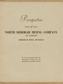 Bendigo Historical Society Inc.
Document - MCCOLL, RANKIN AND STANISTREET COLLECTION: PROSPECTUS OF NORTH DEBORAH MINING COMPANY NL, 1937
McColl Rankin & Stanistreet, Prospectus of North Deborah Mining Co NL. Date: 17 April 1937. Book soft cover 6 copies; A/ Excellent condition map and applicant form intact. B/ Good condition. Map and application form intact, copy has been folded down middle. Inscription on front cover, date altered to 1938, No 1978. C/ Good condition. Map and application intact. D/ Map intact, application removed. Good condition. Map intact, application removed. Good condition. F/ Application removed, map intact, prospectus removed, fair condition. Markings: on page 2, 3, 4, & 6. G/ Application removed, map intact, fair condition. Markings on page;2, 3, 4, & 5.organization, mining, north deborah mining company nl, mccoll rankin & stanistreet, prospectus of north deborah mining co nl. date: 17 april 1937 map application form -
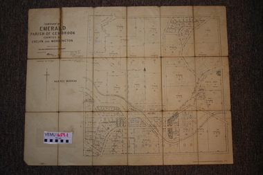 Emerald Museum & Nobelius Heritage Park
Two maps of Emerald Township 1955 and 1922, Emerald Township
The Photo Lithographed Maps belonged to George and Mary A'Vard. They are early maps of Emerald Township in 1955 and 1922.VEMU1659.1 Township of Emerald, Parish of Gembrook, Counties of Evelyn and Mornington; September 1955 VEMU1659.2 Township of Emerald, Parish of Gembrook, Counties of Evelyn and Mornington: Drafted 12 Sep 1892, Examined 30 Sep 1892, Additions 17 Jun 1922 -
 Ringwood and District Historical Society
Poster, Land Sale Advertisement - Pinemont Estate, Ringwood, Victoria - circa 1924
Map of residential allotments for sale, with terms of sale, summary of subdivision features and local services and facilities, and photographs of local street scene and lake (Loughnan's Lake - location not marked), Subdivision includes Wonga Road (later Loughnan's Road), Glenvale Road, Kubba Road, Felix Crescent, Summit Crescent, Pine Crescent, Aurum Crescent, Hygeia Parade, Panorama Avenue, Avalon Grove, Montalbo Road, Cielterre Avenue. Sole Agents T.M. Burke Pty Ltd, 340 Collins Street Melbourne Phones 6294, 6779. Map by S. Callanan, Licensed Surveyor, 107 Elizabeth Street Melbourne. Date of poster estimated from railway services information extract " ... 36 fast electric trains to Flinders Street daily ... proposed electrification to Croydon ..." . Timeline for electrification of Lilydale Line record indicates Box Hill to Ringwood January 1923, Ringwood to Croydon November 1924 (Source: History of Croydon - McGivern, Vol.1 p20). -
 Bacchus Marsh & District Historical Society
Map, Plan of land purchased by the Bacchus Marsh Shire Council from Mr. T. Low for a deviation of the Melbourne to Ballarat main road. 1877
The date of this plan is 1877 and the land indicted on it required for a road deviation is shaded in blue. It adjoins the Korkuperrimul Creek on one side which indicates the land is located just a few kilometers to the west of Bacchus Marsh. Single page map showing a portion of land purchased by the Bacchus Marsh Shire from Mr Thomas Low for the purpose of a road deviation. Land held by David Robertson is also shown on the map. Scale: 2 chains to 1 inch. Part of a set of maps which are pasted into a bound volume containing 76 maps or plans in total. High resolution digital image stored on BMDHS computer network. Surveyed by W. E. Standfield, Shire Engineer, Bacchus Marsh, 12/4/77bacchus marsh roads and streets, melbourne to ballarat road -
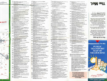 Melbourne Tram Museum
Map, The Met, "Public Transport Map of Melbourne", June 1992
Map - 36 fold - 9 x 2 x 2- colour map of public transport including buses, titled "Public Transport Map of Melbourne", published by the Public Transport Corporation, Effective June 1992. Gives rail and tram maps, information on tickets. Has The Met contact details. 2 copies held .1 - as above but a 6 fold DL, dated Jan 8, 1995trams, tramways, map, ptc, melbourne, the met -
 Federation University Historical Collection
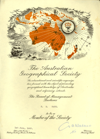
Certificate, Australian Geographical Society, Australian Geographical Society certificate made out to Keith Rash, 1957, 01/06/1957
Certificate of the Australian Geographical Society made out to Keith Rash. One printed page, map of Oceania including sailing ship, torch, map of Australia and surrounding islands. G. B. Walker (signature)rash, keith rash, australian geographical society, g.b. walker -
Bendigo Historical Society Inc.
Map - SERPENTINE, No date Visible
Map: Township of Janiember (name crossed out and 'Serpentine' hand written in its place, Parish of Janiember east, County of Bendigo ( number 156 in Map Cupboard 1)map, bendigo, township, serpentine, janiember, parish of janiember east, county of bendigo -
Bendigo Historical Society Inc.
Map - PASTORAL HOLDINGS, See above
Map: Copy of 'Map showing the Pastoral Holdings of the Port Phillip District 1835-51, Now Victoria'. Comiled by A.S.Kenyon M.I.E. Aus. Historical society of Victoria 1932map, victoria, pastoral holdings, pastoral holdings, port phillip district -
 National Vietnam Veterans Museum (NVVM)
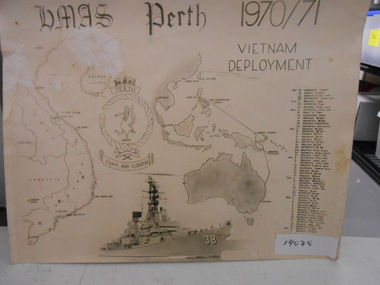
Document, HMAS Perth 1970/71 Vietnam Deployment
Black and white Collage with Map of Vietnam, HMAS Perth Badge, Photograph of HMAS Perth, Map and History of Hmas Perth's Deployment from Sept 1970 to April 1971.Flight & Flourishdocument, hmas perth, d38 -
Tatura Irrigation & Wartime Camps Museum
Map - Plaster Cast, Map of Australia, 1940's
Made by POW at Dhurringile Internment CampMap of Australia, plaster cast, bell shaped, in which is a copper penny and a rosella atop Cape York. Dated 1940 words "Tatura Vic" below map of Australia1940 Tatura- Dhurringile intern Campplaster caste, map of australia, layton family, dhurringile camp, tatura, camp, ornament, plaster -
 Sunshine and District Historical Society Incorporated
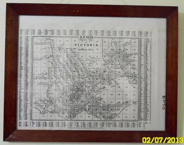
Map (1939), RAILWAYS OF VICTORIA, Including Passenger Mileage, 4 April 1939, 1939
Historical record of the railway line system in the state of Victoria in 1939. Many of the railway lines no longer exist.Map showing the RAILWAY LINES of VICTORIA plus PASSENGER MILEAGES as of 4.4.1939. The white map with black printing is enclosed within a glass faced brown stained wooden frame.victoria, railway map, 1939, rail, passenger mileage -
Beechworth Honey Archive
Map- Albury
Map centred on Albury, showing Wodonga, Beechworth, Yackandandah and Chiltern. Topographic survey scale 1:100,000. Map is colour, printed on paper. Produced by Department of Minerals and EnergySheet 8225 (ed.1) series R. 652 Notes written on side regarding brigade boundaries, constructed access roads and fire trails, dams suitable for quick fill pump and areas 'fuel reduction burns Autumn 76'.map, albury, wodonga, beechworth, yackandandah, chiltern, paper, topographic, beechworth honey -
 Wodonga & District Historical Society Inc
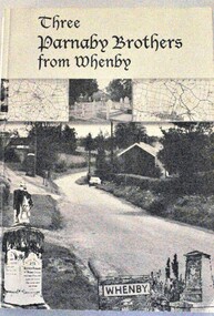
Book - Three Parnaby Brothers from Whenby, Julie Walker and Judy Crook, 2000
This book documents the story of the Parnaby Brothers who migrated to Australia from Whenby in North Yorkshire, England via Natal in South Africa. They settled in the Wodonga district of Victoria. The dedication on page 3 of the book says "To George, William and Matthew Parnaby. We can only wonder at the adventurous spirit, courage and fortitude of the three brothers who arrived in this country with an ambition to better themselves and provide for their families." George arrived at Port Melbourne from Port Natal on 11 January 1864. On the same voyage was his brother William and a nephew Charles. George and his wife Rachel settled at Howlong on the Victoria/NSW border where he worked as a farmer and labourer. George died at Howlong on 26 JUne 1887. William and his son Charles settled in Albury. In 1869/70 he was listed as a property owner at Wooragee, including a house, farm and vineyard. William died in Albury on 20 February 1894. Matthew originally arrived in Hobsons Bay, Victoria in 1854. After 6 years on the goldfields he returned to South Africa and then to England to marry. They eventually returned to Australia in 1863. After some time in Melbourne, Matthew moved to Belvoir (Wodonga). By August 1877 he owned 104 acres of grazing land at House Creek. He steadily became one of the most successful farmers in the district and increased his landholdings. He spent the remainder of his life in Wodonga where he served as a member of the Shire Council for some years. Matthew never forgot his birthplace and called his property "Whenby Grange". He died in Wodonga on 7 October 1903.A volume of 342 pages, including photos and maps. The cover includes images of the town of Whenby, maps and the grave of Matthew Parnaby who died in Wodonga on 7 October 1903.This book documents the story of the Parnaby Brothers who migrated to Australia from Whenby in North Yorkshire, England via Natal in South Africa. They settled in the Wodonga district of Victoria. The dedication on page 3 of the book says "To George, William and Matthew Parnaby. We can only wonder at the adventurous spirit, courage and fortitude of the three brothers who arrived in this country with an ambition to better themselves and provide for their families." George arrived at Port Melbourne from Port Natal on 11 January 1864. On the same voyage was his brother William and a nephew Charles. George and his wife Rachel settled at Howlong on the Victoria/NSW border where he worked as a farmer and labourer. George died at Howlong on 26 JUne 1887. William and his son Charles settled in Albury. In 1869/70 he was listed as a property owner at Wooragee, including a house, farm and vineyard. William died in Albury on 20 February 1894. Matthew originally arrived in Hobsons Bay, Victoria in 1854. After 6 years on the goldfields he returned to South Africa and then to England to marry. They eventually returned to Australia in 1863. After some time in Melbourne, Matthew moved to Belvoir (Wodonga). By August 1877 he owned 104 acres of grazing land at House Creek. He steadily became one of the most successful farmers in the district and increased his landholdings. He spent the remainder of his life in Wodonga where he served as a member of the Shire Council for some years. Matthew never forgot his birthplace and called his property "Whenby Grange". He died in Wodonga on 7 October 1903.parnaby family, whenby england, whenby grange wodonga -
Stawell Historical Society Inc
Map, Township of Stawell
B/W map of Stawell Surveyed by Easton Johnston Contract surveyor Scale in Chains. Showing Special Allotments Reefs, Pleasant Creek Parish of Stawell. Map No L4000 -
Clunes Museum
Book - BUSINESS DIRECTORY, UNIVERSAL BUSINESS DIRECTORIES (AUST) PTY LTD, UBD BUSINESS AND STREET DIRECTORY 1971, 1971
BUSINESS AND STREET DIRECTORY OF BALLARAT AND SURROUNDING DISTRICTSRED COVERED DIRECTORY WITH MAP OF VICTORIA ON THE COVER. 36 PAGES OF BUSINESS ADVERTISING AND ADDRESSES WITH SOME MAPS OF BALLARAT AND SURROUNDING DISTRICTS. PAGE 46 SHOWS CLUNES BUSINESSES.non-fictionBUSINESS AND STREET DIRECTORY OF BALLARAT AND SURROUNDING DISTRICTSregional businesses, clunes businesses -
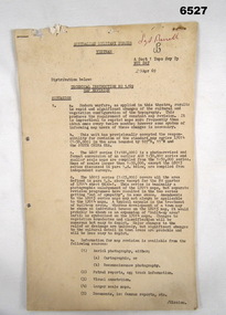 Bendigo Military Museum
Administrative record - Australian Military Forces Vietnam - Technical Instruction 1/69 - Map Revision, Major EP Constantine, Nui Dat, Vietnam, 29 Apr 1969
This is a Technical Instruction to formalise the Map Revision process at the Royal Australian Survey Corps, A Sect 1 Topo Svy Tp, NUI Dat, Vietnam in 1969. This Instruction details the methods to be used to manage the updating of the current theatre mapping to ensure map users are advised of the latest map changes, either additions or deletions from when the original map was produced.11 x foolscap pages of typed text and diagrams, stapled and two hole punched. Paper dis-colouredHand written top right hand corner in red "Sgt Birrell"royal australian survey corps, rasvy, fortuna, army survey regiment, army svy regt, asr, australian force vietnam -
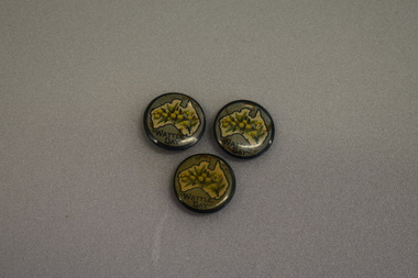 Warrnambool and District Historical Society Inc.
Badges, Wattle Day
These badges appear to have been issued as part of Wattle Day celebrations in the period 19910 to 1919. The use of wattle as an Australian symbol was strong during the pre- Federation and Federation days and was particularly promoted by the Australian Natives Association, a prominent campaigner for Federation. Wattle Day was established in Melbourne, Sydney and Adelaide in 1910 and the wattle symbol was a strong one for servicemen serving overseas in World War One and wattle badges and pins were used to raise funds for funds such organisations as the Red Cross.These badges are of interest as an example of the strong national sentiment engendered on Australia by World War One..1 circular metal concave badge featuring a cream map of Australia with dark green outline. An image of wattle flowers and leaves is in the centre of the map. Surrounding the map is a pale green border with text. The edge is dark green. It has a pin clip on the reverse. .2 As above .3 As above .1 WATTLE DAY .2 WATTLE DAY .3 WATTLE DAY -
Bendigo Historical Society Inc.
Map - CAMPBELL COLLECTION: BENDIGO AND DISTRICT MAPS, 2-2-29
Map. Wellsford, Parishes of Wellsford and Axedale, Scale 20 chains to 1 inch. Total area 4994 acres. Prepared in W.P.B. from A and P Plans, by W.J.G.2-2-29. Top left of map are directions to Fosterville, Huntly & Bendigo. (number 361 in map cupboard 1)W.J.Galbraithmap, bendigo, parish plan -
Tatura Irrigation & Wartime Camps Museum
Book, Edward M. Curr. The Tide of History
Map of the runs of the late E. M. Curr, St. Helliers. Recollections of squatting in Victoria. Map of Angerang Territory.Front cover profile in red of E. M. Curr. Cover images. Signed by Samuel Furphy, authoredward m curr, st helliers, angerang territory -
Glenelg Shire Council Cultural Collection
Pamphlet, Historic Portland Buildings Open Day, 1970s
Camperdown and District Heritage Society, Collection.Two copies of black and white pamphlet to commemorate the first permanent settlement in Victoria, Historic Portland Buildings Open Day.Front: Black and white image of Gardens cottage Back: Black and white map of Historic Portland buildingshistoric buildings, buildings of portland, tourism, local history -
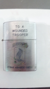 National Vietnam Veterans Museum (NVVM)
Functional Object - Cigarette Lighter
Silver lighter with inscription and 173rd Airborne graphic.To a wounded Trooper. Unit badge of 173rd Airborne (SED). Penguins, High Quality Lighter & a map of Vietnam.cigarette lighter, 173rd airborne brigade -
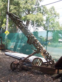 Puffing Billy Railway
Machine - Conveyor / Loader, Munro Engineers Pty Ltd, 1955
Munro Engineers Pty Ltd, Handilift Stacker & Loader' The Land on which the Menzies Creek railway station and Museum are built on was once apart of James Hermon's & his son William Hermon's property on which this Munro Handilift Stacker & Loader was used. Historic -Industrial Tool - Handilift Stacker & Loader - used on Jame's Hermon's property on which the Menzies Creek Railway is built on Munro Engineers Pty Ltd, Handilift Stacker & Loader made of steel and wood and wrought ironMunro Engineers Pty ( symbol map of Australia ) Ltd, Ballarat Vic. On side - No. 3147 On wheel - no, 2052puffing billy, munro engineers, handilift stacker & loader, hermon, menzies creek