Showing 8885 items
matching south road
-
 Eltham District Historical Society Inc
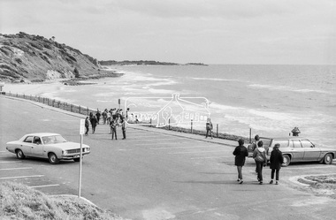
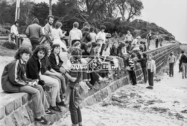
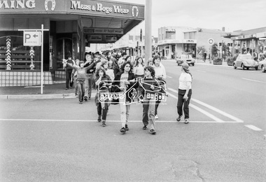
Photograph, George Coop, Sunnyside Beach, Mount Eliza, c.August 1983, 1983
Possibly an excursion or school camp for Year 8 or 9 students from Nunawading High School to the seaside at Mount Eliza. Nunawading High School opened on Canterbury Road (near Mahoneys Road) in 1955. Enrolments grew rapidly and by 1969 there were over 1,100 students, making it one of the largest schools in the state. In 1989 it was merged with Burwood Heights High and Blackburn South High to become a junior campus of Forest Hills Secondary College. However, the junior campuses were closed in 1997, and the former Nunawading High was bulldozed to make way for a housing estate. "Lost Schools of the 1990s", Learning from the Past, http://learningfromthepast.com.au/lost-schools-of-the-1990s/ George Coop was a teacher of art, craft, wood working and graphics at Nunawading High School until it merged into Forest Hills Secondary College at which point he retired.Digital TIFF file Scan of 35mm Kodak Safety 5062 black and white transparencymount eliza, nunawading high school, sunnyside beach -
 Eltham District Historical Society Inc
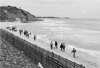
Photograph, George Coop, Sunnyside Beach, Mount Eliza, c.August 1983, 1983
Possibly an excursion or school camp for Year 8 or 9 students from Nunawading High School to the seaside at Mount Eliza Nunawading High School opened on Canterbury Road (near Mahoneys Road) in 1955. Enrolments grew rapidly and by 1969 there were over 1,100 students, making it one of the largest schools in the state. In 1989 it was merged with Burwood Heights High and Blackburn South High to become a junior campus of Forest Hills Secondary College. However, the junior campuses were closed in 1997, and the former Nunawading High was bulldozed to make way for a housing estate. "Lost Schools of the 1990s", Learning from the Past, http://learningfromthepast.com.au/lost-schools-of-the-1990s/ George Coop was a teacher of art, craft, wood working and graphics at Nunawading High School until it merged into Forest Hills Secondary College at which point he retired.Digital TIFF file Scan of 35mm Kodak Safety 5062 black and white transparencymount eliza, nunawading high school, sunnyside beach -
 Eltham District Historical Society Inc
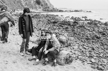
Photograph, George Coop, Sunnyside Beach, Mount Eliza, c.August 1983, 1983
Possibly an excursion or school camp for Year 8 or 9 students from Nunawading High School to the seaside at Mount Eliza Nunawading High School opened on Canterbury Road (near Mahoneys Road) in 1955. Enrolments grew rapidly and by 1969 there were over 1,100 students, making it one of the largest schools in the state. In 1989 it was merged with Burwood Heights High and Blackburn South High to become a junior campus of Forest Hills Secondary College. However, the junior campuses were closed in 1997, and the former Nunawading High was bulldozed to make way for a housing estate. "Lost Schools of the 1990s", Learning from the Past, http://learningfromthepast.com.au/lost-schools-of-the-1990s/ George Coop was a teacher of art, craft, wood working and graphics at Nunawading High School until it merged into Forest Hills Secondary College at which point he retired.Digital TIFF file Scan of 35mm Kodak Safety 5062 black and white transparencymount eliza, nunawading high school, sunnyside beach -
 Eltham District Historical Society Inc
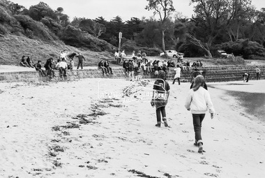
Photograph, George Coop, Sunnyside Beach, Mount Eliza, c.August 1983, 1983
Possibly an excursion or school camp for Year 8 or 9 students from Nunawading High School to the seaside at Mount Eliza Nunawading High School opened on Canterbury Road (near Mahoneys Road) in 1955. Enrolments grew rapidly and by 1969 there were over 1,100 students, making it one of the largest schools in the state. In 1989 it was merged with Burwood Heights High and Blackburn South High to become a junior campus of Forest Hills Secondary College. However, the junior campuses were closed in 1997, and the former Nunawading High was bulldozed to make way for a housing estate. "Lost Schools of the 1990s", Learning from the Past, http://learningfromthepast.com.au/lost-schools-of-the-1990s/ George Coop was a teacher of art, craft, wood working and graphics at Nunawading High School until it merged into Forest Hills Secondary College at which point he retired.Digital TIFF file Scan of 35mm Kodak Safety 5062 black and white transparencymount eliza, nunawading high school -
 Eltham District Historical Society Inc
Photograph, George Coop, Sunnyside Beach, Mount Eliza, c.August 1983, 1983
Possibly an excursion or school camp for Year 8 or 9 students from Nunawading High School to the seaside at Mount Eliza Nunawading High School opened on Canterbury Road (near Mahoneys Road) in 1955. Enrolments grew rapidly and by 1969 there were over 1,100 students, making it one of the largest schools in the state. In 1989 it was merged with Burwood Heights High and Blackburn South High to become a junior campus of Forest Hills Secondary College. However, the junior campuses were closed in 1997, and the former Nunawading High was bulldozed to make way for a housing estate. "Lost Schools of the 1990s", Learning from the Past, http://learningfromthepast.com.au/lost-schools-of-the-1990s/ George Coop was a teacher of art, craft, wood working and graphics at Nunawading High School until it merged into Forest Hills Secondary College at which point he retired.Digital TIFF file Scan of 35mm Kodak Safety 5062 black and white transparencymount eliza, nunawading high school -
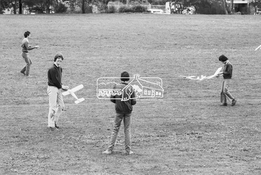
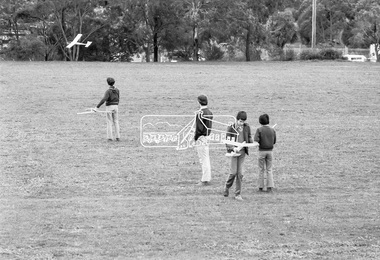
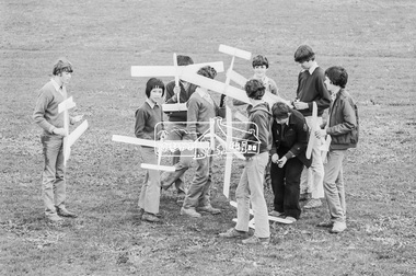
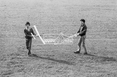 Eltham District Historical Society Inc
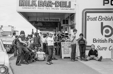
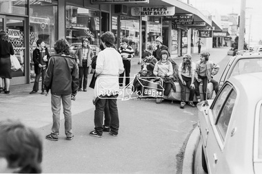
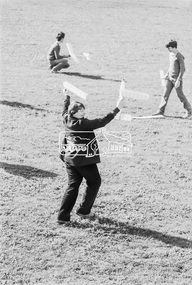
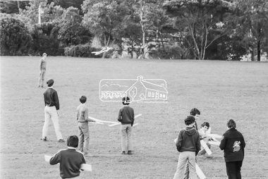
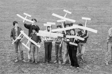
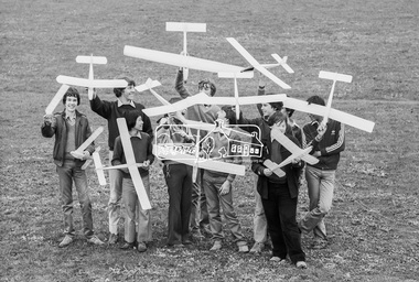
Photograph, George Coop, Balsa wood model airplane construction class, Nunawading High School, Canterbury Road, c.August 1983, 1983
Teachers at Nunawading High School were required to hold one afternoon a week with students undertaking some form of activity. There were various clubs such as gardening, chess, etc. Given George's background with art, craft and woodwork, he organised an activity for students to assemble balsa wood airplane kits which were test flown on the school grounds; Canternury Road in the background. Nunawading High School opened on Canterbury Road (near Mahoneys Road) in 1955. Enrolments grew rapidly and by 1969 there were over 1,100 students, making it one of the largest schools in the state. In 1989 it was merged with Burwood Heights High and Blackburn South High to become a junior campus of Forest Hills Secondary College. However, the junior campuses were closed in 1997, and the former Nunawading High was bulldozed to make way for a housing estate. "Lost Schools of the 1990s", Learning from the Past, http://learningfromthepast.com.au/lost-schools-of-the-1990s/ George Coop was a teacher of art, craft, wood working and graphics at Nunawading High School until it merged into Forest Hills Secondary College at which point he retired.Digital TIFF file Scan of 35mm Kodak Safety 5062 black and white transparencycanterbury road,model airplane, nunawading high school -
 Eltham District Historical Society Inc
Photograph, Looking south on Were Street towards Rattray Road, Montmorency, c.1940, 1940c
Other photos of Were St featuring the Dandy family dated 8 October 1950 show an unsealed road with concrete kerb and channeling. The surrounds look very similar but no concrete kerb and trees in footpath significantly younger and smaller in size; hence c.1940Roll of 35mm black and white negative film, sectioned into frames; copy of print photograph Ilford FP-4montmorency, railway station, were street -
 Eltham District Historical Society Inc
Photograph, Hume and Hovell passed here at Seymour 28 Oct 1824, Spring Excursion, Hume and Hovell's 1824 expedition (Part 2), 26 October 1997, 26/10/1997
[article by Diana Bassett-Smith in EDHS Newsletter No. 117, November 1997:] MONUMENT HUNTING THE HUME AND HOVELL WAY - Sunday October 26 1997 dawned bright and very warm. Some twenty-five members, complete with picnic baskets, met outside the Eltham Library awaiting the Cobb and Co. large coach which would be taking us on the second leg of our travels along the route of the early explorers Hume and Hovell. Stephen West was our very good driver for the day. He would be guided around the circuitous route by Russell Yeoman who had made a detailed study, not only of the intended route, but of the story of these two explorers. During the trip Russell regaled us with poetry, quotations from the Journals and the History of the Shire of Seymour, "The New Crossing Place" by Martindale, 1982, (now Mitchell Shire due to the recent amalgamations). We headed towards the Hume Highway via Greensborough and Cooper Street and proceeded north to our first stop, noting on the way Monument Hill in the distance which is near Kilmore and, according to Russell, well worth the effort to visit as the view across the valley is magnificent. Past Sunday Creek Valley, Mt Piper and Mt Disappointment, all traversed and noted and named by them. We passed through Tallarook, then onto Seymour where we took photos of the monument telling us that Hume and Hovell had passed through on the 28th of October 1824. We also deviated down Hume and Hovell Road viewing deer and emu farming and the Bellbourie property now a sanctuary. Leaving Seymour behind we travelled up the Avenel Road to the Avenel monument, pyramidal in design of four reducing square blocks with a sharply pointed peak, erected in 1924 in memory of the 1824 exploration. The day was warming up and the countryside showing the dryness of the current drought. A parallel note had been made in their journal too of 1824 of the drought appearance of the country they were traversing. At Seven Creeks, Euroa we stopped for some minutes to check the monument placed 20th November 1924 to commemorate their passage on the 29th December 1824. More photos. Russell had pointed out the abrupt termination of the distant ranges which is noted in their journal. The next monument is beside the road at the entrance to Honey Suckle Creek Caravan Park, Violet Town. The squarish shaped monument some eight feet high is topped with a simple steel cross, and was to mark the date of 28th December 1824 and built for the 20th November 1924. By now it was 12.20 and nearly lunchtime as we drove along the Warranbayne Road to Roach's Road, monument hunting without success. Though there is a large, what appears to be an old timber sign which was hard to read, maybe this was the lost monument. In many of the paddocks hay had been cut and baled or was being cut, what a contrast to the rugged country they had passed through which was smoky from the fires of the natives burning off. By 1.00 pm we were at Benalla and pulled up beside the park where abundant beds of roses filled the air with their scent and the smell of barbecued food twitched the nostrils whilst the cheerful sounds of other picnickers could be heard throughout the park. We left the bus and collected up our picnics, dispersed to the various tables and enjoyed the shade from the various European trees. 2.00 pm and we were on the road again driving along the Benalla, Mansfield, Yea road. The Swanpool monument states that they passed four miles south and returned three miles north. Then we stopped at the Barjarg monument which notes that they camped near this spot. It is again a pyramidal monument and this time topped with a steel arrow indicating their route of the 29th November 1824. Half an hour later we came to another monument, again with a steel arrow marker on top and the plaque dated the 2nd of 12th 1824. Erected on the 12th of 12th 1924. "They blazed the way that we might inherit the land." Another square based and needle topped monument appeared at Yarck near Yea and this plaque records the date of 3 December 1824. Near McGuigans Road Russell related that the expedition had lost a dog but it had found them next day, the dog was apparently torn by a kangaroo. A short while later Russell reminded us here of the problems they encountered in crossing the Goulburn River near Molesworth where banks were high, water deep and wide. "Good coat of grass but quite dry due to drought". At Yea we stopped for afternoon tea and raided the last of our picnics and looked at the monument to their journey of 1824, situated at a corner of the gardens near the bowling green. No photo – we were out of film. We returned home via Kinglake West and Whittlesea past the Yan Yean Reservoir, not full. 5.00 pm back at Eltham we emptied out of the bus and everyone, including Joan Cole, collected their things, Joan also had the major souvenir of the day, a large carp she had picked up from the river bank, her cat was in for a great feast. The day was made so interesting by the informed commentary which Russell provided. His background knowledge of the route and nature of the journey could only have come from many hours of reading and driving the area. Thank you to Russell and to everyone who made the day so informative and pleasurable. Colour photographactivities, hume and hovell, monument, seymour -
 Eltham District Historical Society Inc
Photograph, Spring Excursion, Hume and Hovell's 1824 expedition (Part 2), 26 October 1997, 26/10/1997
[article by Diana Bassett-Smith in EDHS Newsletter No. 117, November 1997:] MONUMENT HUNTING THE HUME AND HOVELL WAY - Sunday October 26 1997 dawned bright and very warm. Some twenty-five members, complete with picnic baskets, met outside the Eltham Library awaiting the Cobb and Co. large coach which would be taking us on the second leg of our travels along the route of the early explorers Hume and Hovell. Stephen West was our very good driver for the day. He would be guided around the circuitous route by Russell Yeoman who had made a detailed study, not only of the intended route, but of the story of these two explorers. During the trip Russell regaled us with poetry, quotations from the Journals and the History of the Shire of Seymour, "The New Crossing Place" by Martindale, 1982, (now Mitchell Shire due to the recent amalgamations). We headed towards the Hume Highway via Greensborough and Cooper Street and proceeded north to our first stop, noting on the way Monument Hill in the distance which is near Kilmore and, according to Russell, well worth the effort to visit as the view across the valley is magnificent. Past Sunday Creek Valley, Mt Piper and Mt Disappointment, all traversed and noted and named by them. We passed through Tallarook, then onto Seymour where we took photos of the monument telling us that Hume and Hovell had passed through on the 28th of October 1824. We also deviated down Hume and Hovell Road viewing deer and emu farming and the Bellbourie property now a sanctuary. Leaving Seymour behind we travelled up the Avenel Road to the Avenel monument, pyramidal in design of four reducing square blocks with a sharply pointed peak, erected in 1924 in memory of the 1824 exploration. The day was warming up and the countryside showing the dryness of the current drought. A parallel note had been made in their journal too of 1824 of the drought appearance of the country they were traversing. At Seven Creeks, Euroa we stopped for some minutes to check the monument placed 20th November 1924 to commemorate their passage on the 29th December 1824. More photos. Russell had pointed out the abrupt termination of the distant ranges which is noted in their journal. The next monument is beside the road at the entrance to Honey Suckle Creek Caravan Park, Violet Town. The squarish shaped monument some eight feet high is topped with a simple steel cross, and was to mark the date of 28th December 1824 and built for the 20th November 1924. By now it was 12.20 and nearly lunchtime as we drove along the Warranbayne Road to Roach's Road, monument hunting without success. Though there is a large, what appears to be an old timber sign which was hard to read, maybe this was the lost monument. In many of the paddocks hay had been cut and baled or was being cut, what a contrast to the rugged country they had passed through which was smoky from the fires of the natives burning off. By 1.00 pm we were at Benalla and pulled up beside the park where abundant beds of roses filled the air with their scent and the smell of barbecued food twitched the nostrils whilst the cheerful sounds of other picnickers could be heard throughout the park. We left the bus and collected up our picnics, dispersed to the various tables and enjoyed the shade from the various European trees. 2.00 pm and we were on the road again driving along the Benalla, Mansfield, Yea road. The Swanpool monument states that they passed four miles south and returned three miles north. Then we stopped at the Barjarg monument which notes that they camped near this spot. It is again a pyramidal monument and this time topped with a steel arrow indicating their route of the 29th November 1824. Half an hour later we came to another monument, again with a steel arrow marker on top and the plaque dated the 2nd of 12th 1824. Erected on the 12th of 12th 1924. "They blazed the way that we might inherit the land." Another square based and needle topped monument appeared at Yarck near Yea and this plaque records the date of 3 December 1824. Near McGuigans Road Russell related that the expedition had lost a dog but it had found them next day, the dog was apparently torn by a kangaroo. A short while later Russell reminded us here of the problems they encountered in crossing the Goulburn River near Molesworth where banks were high, water deep and wide. "Good coat of grass but quite dry due to drought". At Yea we stopped for afternoon tea and raided the last of our picnics and looked at the monument to their journey of 1824, situated at a corner of the gardens near the bowling green. No photo – we were out of film. We returned home via Kinglake West and Whittlesea past the Yan Yean Reservoir, not full. 5.00 pm back at Eltham we emptied out of the bus and everyone, including Joan Cole, collected their things, Joan also had the major souvenir of the day, a large carp she had picked up from the river bank, her cat was in for a great feast. The day was made so interesting by the informed commentary which Russell provided. His background knowledge of the route and nature of the journey could only have come from many hours of reading and driving the area. Thank you to Russell and to everyone who made the day so informative and pleasurable. Colour photographactivities, hume and hovell, bridge -
 Eltham District Historical Society Inc
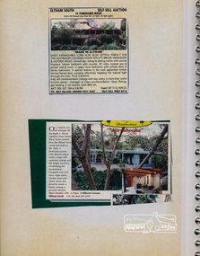
Newsclipping, 33 Fordhams Road and Mirabooka, 3 Hillcrest Avenue, Eltham South
Contained in Volume 1 of a set of two spiral magnetic photo albums, each containing 10 leaves, 20 pages; Vol. 1 labelled "Houses - Eltham South" and Vol. 2 labelled "Eltham Houses". Newspaper clippings advertising house auctionseltham, eltham south, real estate advertisement, houses, fordhams road, hillcrest avenue, mirabooka -
 Eltham District Historical Society Inc
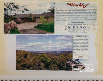
Newsclipping, Winchley, 179 Old Eltham Road, Lower Plenty and Warrakilla
Contained in Volume 1 of a set of two spiral magnetic photo albums, each containing 10 leaves, 20 pages; Vol. 1 labelled "Houses - Eltham South" and Vol. 2 labelled "Eltham Houses". Newspaper clippings advertising house auctionseltham, eltham south, real estate advertisement, houses, neville emerson real estate, old eltham road, warrakilla, winchley -
 Eltham District Historical Society Inc
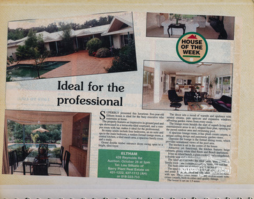
Newsclipping, 104 Lavender Park Road; 2 Porter Street, Eltham Gateway, May 1994, 1994
Contained in Volume 1 of a set of two spiral magnetic photo albums, each containing 10 leaves, 20 pages; Vol. 1 labelled "Houses - Eltham South" and Vol. 2 labelled "Eltham Houses". Newspaper clippings promoting house auctionseltham, eltham south, real estate advertisement, houses, ian reid real estate, lavender park road, porter street -
 Eltham District Historical Society Inc
Newsclipping, 439 Reynolds Road, Eltham
Contained in Volume 1 of a set of two spiral magnetic photo albums, each containing 10 leaves, 20 pages; Vol. 1 labelled "Houses - Eltham South" and Vol. 2 labelled "Eltham Houses". Newspaper clipping promoting house auctioneltham, eltham south, real estate advertisement, houses, reynolds road -
 Eltham District Historical Society Inc
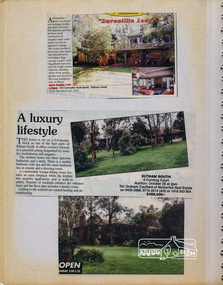
Newsclipping, Duranillin Lodge, 104 Lavender Park Road, and 6 Corrong Court, Eltham South
Contained in Volume 1 of a set of two spiral magnetic photo albums, each containing 10 leaves, 20 pages; Vol. 1 labelled "Houses - Eltham South" and Vol. 2 labelled "Eltham Houses". Newspaper clippings promoting house auctionseltham, eltham south, real estate advertisement, houses, ian reid real estate, corrong court, duranillin lodge, lavender park road, mcgorlick real estate -
 Eltham District Historical Society Inc
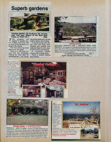
Newsclipping, 29 Fordhams Road, Culla Hill, Sweeneys Lane, Wombat Cottage and 9 Wild Cherry Drive, Eltham South and St Julien, Research
Contained in Volume 2 of a set of two spiral magnetic photo albums, each containing 10 leaves, 20 pages; Vol. 1 labelled "Houses - Eltham South" and Vol. 2 labelled "Eltham Houses". Newspaper clippings promoting house auctionseltham, real estate advertisement, houses, culla hill, fordhams road, ian reid real estate, research (vic.), st. julien, sweeneys lane, wild cherry drive, wombat cottage -
 Eltham District Historical Society Inc
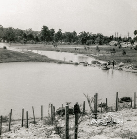
Photograph, Looking north across Eltham Town Park, 1974, 1974
Visible are Trestle Bridge, Eltham Shire Offices with south wing extension, duplicated Main Road, Panther Place and the pathway through the park. Shillinglaw Cottage in Eltham Common on the other side of Panther Place is hidden from view by the tree-capped grassy knoll. The two ponds were in construction during the Arbor Day native tree planting by local school children in October 1973.Black and white photographeltham town park, eltham shire office, main road, shillinglaw trees, trestle bridge -
 Eltham District Historical Society Inc
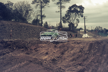
Photograph, Road works looking south, Diamond Street, Eltham, 4 August 1967, 1967
... Road works looking south, Diamond Street, Eltham, 4 August... melbourne diamond street, eltham, road construction 35mm Colour ...35mm Colour positive transparency Mount - Agfacolor Service (Blue stepped)diamond street, eltham, road construction -
 Eltham District Historical Society Inc
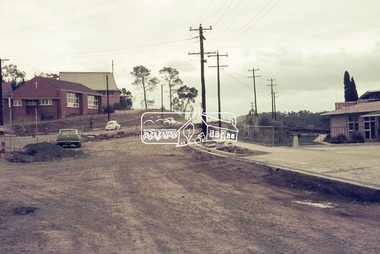
Photograph, Looking south from Eltham Shire Office at roadworks for Main Road widening, 2 May 1968, 1968
35mm Colour positive transparency Mount - Agfacolor Service (Blue stepped)duplication, eltham, main road, road construction -
 Eltham District Historical Society Inc
Photograph, Roadworks, Main Road widening, Eltham, 15 July 1968, 1968
Looking south from near the Shire offices35mm Colour positive transparency Mount - Agfacolor Service (Blue stepped)duplication, eltham, main road, road construction -
 Eltham District Historical Society Inc
Photograph, Roadworks, Main Road widening, Eltham, c.15 July 1968, 1968
Looking south past Eltham War Memorial on right.35mm Colour positive transparency Mount - Agfacolor Service (Blue stepped)dudley street, duplication, eltham, eltham war memorial, main road, our lady of help christians church, our ladys school, road construction, war memorial garden, war memorial gates