Showing 15583 items
matching stillwell-valley
-
 Kiewa Valley Historical Society
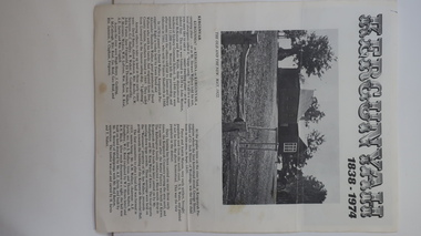
Leaflet - Kergunyah, Kergunyah 1838 - 1974, 1974
Kergunyah is a small town in the Kiewa Valley in north east Victoria. It is 10km south of Kiewa (town) and 23 km north of Dederang (town). it is farming country commencing in 1838, developing into a small community in 1974 with a School, Church, Post Office, Football Club, Young Farmer Club C.W.A. Netball Club, Card Club and Fire Brigade.Kergunyah is in the Kiewa Valley. Its history is important in the valley as it developed from a large pastoral run in 1838 into a small community supporting the local farming industry with essential organisations eg. school, fire brigade and social organisations eg. sporting teams, C.W.A.. Its history is significant as this leaflet has details of the organisations up to 1974 and this detail can be compared to organisations at Kergunyah today and can be compared to the history of other small rural communities. White stiff paper, folded to A4 size, with black and white photos on each of the 4 pages. Each page has detailed information under headings of community buildings and clubs in the small town. kergunyah; kiewa valley; small community; rural town; -
 Kiewa Valley Historical Society
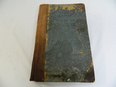
Ledger - Tawonga Store 1915 to 1920s, c1915
The Tawonga Store was a general store in the Upper Kiewa Valley providing for a farming community. This store which had a variety of items was the main store for many of the farming families who would travel on horse and cart to make weekly trips to the store for supplies. This ledger was used by the owner of Tawonga Store to keep a record of items sold and to whom. George Potter owned the Tawonga Store before 1920. Whit Potter, George's son, worked with his father for many years. Attached to this ledger is a sheaf of letters which were sent to the Potter's, which are relevant to the day to day operation of a General Store. The ledger gives a comprehensive list of what type of items the residents of the Kiewa Valley purchased during this period, thus has great historical significance. It is well provenanced and very good interpretive capacity. Green linen covered cardboard cover. Brown (leather look) paper spine. Inside cover is red and green marbled paper. It has an alphabetic index at front. 262 ledger pages, the edges of which have been marbled.Ledger - printed on a red square embossed in gold on a brown thick paper spinetawonga, general store, book-keeping, ledger, george potter, whit potter -
 Eltham District Historical Society Inc
Document - Folder, Metzeling, Bertha
Bertha Metzeling, at 91, emigrated from Sri Lanka to Australia to join other family members. Contents Newspaper article: " 'Elder lady' enjoys new lifestyle", Diamond Valley News, 15 July 1986. Describes Bertha Metzeling's life in Sri Lanka until she emigrated to Australia, aged 91, and her life now.Newspaper clippings, A4 photocopies, etcbertha metzeling, sir lanka -
Eltham District Historical Society Inc
Document - Folder, McKellan, Robert and Thelma
Bob and Thelma McLellan presented chains of office to be work by the Eltham Shire President at council functions during their term of office. The chain was made by Matcham Skipper. The McLellan family had been connecting with the shire for more than 100 years. Contents Newspaper article: "Office regalia" Diamond Valley News, 14 August 1990,Newspaper clippings, A4 photocopies, etcrobert mclellan, thelma mclellan, matcham skipper -
Eltham District Historical Society Inc
Document - Folder, Metzeling, Bertha
Bertha Metzeling, at 91, emigrated from Sri Lanka to Australia to join other family members. Contents Newspaper article: " 'Elder lady' enjoys new lifestyle", Diamond Valley News, 15 July 1986. Describes Bertha Metzeling's life in Sri Lanka until she emigrated to Australia, aged 91, and her life now.Newspaper clippings, A4 photocopies, etcbertha metzeling, sir lanka -
 Federation University Historical Collection
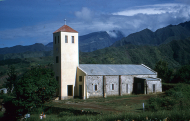
Slide, Eglise du Bras de Pontho (Church of the Holy Angels of Bras de Pontho), c1970
A small wooden chapel was built on this site but was destroyed by a cyclone in 1948. It was immediately replaced by the present church, which has simple architecture and interior ornaments. The concrete building is a large rectangle to which is added a square tower supporting a small bell tower. From the church site you can view the Bras de la Plaine valley Photograph of a church Handwritten "Eglise du Bras de Pontho" Stamped "R. Ueberschlag"eglise du bras de pontho, church of the holy angels of bras de pontho, church, bras de la plaine valley -
Greensborough Historical Society
Newsletter, Greenhills and North Greensborough Progress Association, Community News: official journal of the Greenhills and Nth. Greensborough Progress Association. 26th February, 1974. Edition No. 1/74, 28/02/1974
This edition includes a report on the Progress Association's February 1974 meeting, Councillor's report, Sporting facilities in Diamond Valley, Ian Bennet, Mr. Poulter's report on child care, From the Council Chamber, Poisonous plants and trees. Supplement to February 1974 "Community News" Join in the fun of the fair at... The 1974 Diamond Ck. town fair.Newsletter, 16 p., illus.greenhills and north greensborough progress association, greenhills -
Greensborough Historical Society
Newsletter, Greenhills and North Greensborough Progress Association, Community News: official journal of the Greenhills and Nth. Greensborough Progress Association and the Apollo Parkways Progress Association. 4th April, 1977. Edition No. 3/77, 04/04/1977
Proposed shopping complex: Greensborough shopping centre debate, Information or consultation - which? The Greensborough shopping centre... two way communication, I remember when, Meet the natives, Diamond Valley Civic Centre Library, This and that, Local fauna controversy, Women's recreation, From the Council Chamber; Apollo Parkways street names, Kinder news. Newsletter, 20 p., illus.greenhills and north greensborough progress association, greenhills, apollo parkways progress association, apollo parkways -
Greensborough Historical Society
Newsletter, Greenhills and North Greensborough Progress Association, Community News: official journal of the Greenhills and Nth. Greensborough Progress Association and the Apollo Parkways Progress Association. June 1978. Edition No. 5/78, 06/1978
Of mice, men & motorways, Diamond Valley Railway, Who runs your home? You or T.V.?, Real adventure playgrounds, The Montessori method, Septic tanks **!!***!!!, Depression, Kinder news, Nillumbik Historical Society, Karingal Tennis Club, Nursing Mothers Association, Parent Australia, From the Council Chamber, Montmorency & District Horticultural Society, This and that.Newsletter, 23 p., illus.greenhills and north greensborough progress association, greenhills, apollo parkways progress association, apollo parkways -
 Greensborough Historical Society
Map, Melbourne and Metropolitan Board of Works. Survey Division, MMBW, Yarra 2500 / 11.22. Bundoora, 1979_01
Melbourne and Metropolitan Board of Works. Yarra 2500 [base map] 11-22. Bundoora. Parish of Keelbundoora 2856, Municipalities of Diamond Valley 257 and Whittlesea 239. Prominent streets include: Greenhills Road, Cabernet Crescent and Plenty Road. Includes Parade College (Christian Brothers) and "proposed future freeway" (now Metropolitan Ring Road)MMBW Map in 1:2500 [scale] series. Cream parchment with green tape reinforcing on edges and punched holes on left edge.mmbw, melbourne and metropolitan board of works, shire of diamond valley, bundoora - maps -
 Greensborough Historical Society
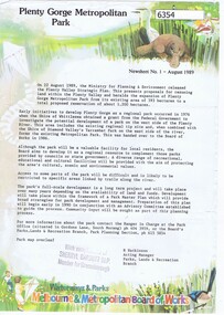
Newsletter, Plenty Gorge Metropolitan Park Newsheet No. 1 August 1989, 1989_08
The Shire of Whittlesea obtained a grant from the federal government to investigate the potential development of a park to the west of the Plenty River in 1976. A regional tip site and the Shire of Diamond Valley's Yarrambat Park were handed over to the MMBW to form the existing Metropolitan Park in 1986. A long term project to develop the park further is to commence in 1990.2 p. text, map and col. illus."With compliments of Sherryl Garbutt M.P. Member for Greensborough" (rubber stamp)plenty gorge park -
 Greensborough Historical Society
Map, Melbourne and Metropolitan Board of Works. Survey Division, MMBW, Yarra 2500 / 15.21. Eltham North, 1979_08
Melbourne and Metropolitan Board of Works. Yarra 2500 [base map] 15.21. Eltham North. Parish of Nillumbik 3310. Municipalities of Diamond Valley 257 and Eltham 238. Prominent streets include: Progress Road, Glen Park Road and Zig Zag Road. Features include the Diamond Creek, Eltham Council Pound and Eltham North Reserve.MMBW Map in 1:2500 [scale] series. Cream parchment with green tape reinforcing on edges and punched holes on left edge.mmbw, melbourne and metropolitan board of works, shire of diamond valley, nillumbik, eltham - maps -
 Greensborough Historical Society
Map, Melbourne and Metropolitan Board of Works. Survey Division, MMBW, Yarra 2500 / 14.23. Diamond Creek, Sutherland Homes, 1979_05
Melbourne and Metropolitan Board of Works. Yarra 2500 [base map] 14.23. Diamond Creek, Sutherland Homes. Parish of Morang 3183 and Nillumbik 3310. Municipality of Diamond Valley 257. Prominent streets Aqueduct Road, Diamond Creek Road, Yan Yean Road and McLaughlans Lane. Features include the abandoned Maroondah aqueduct and Sutherland Cottages.MMBW Map in 1:2500 [scale] series. Cream parchment with green tape reinforcing on edges and punched holes on left edge.mmbw, melbourne and metropolitan board of works, shire of diamond valley, plenty - maps, sutherland homes, maroondah aqueduct -
 Greensborough Historical Society
Map, Melbourne and Metropolitan Board of Works. Survey Division, MMBW, Yarra 2500 / 13.28. Mernda, Wilton Vale, 1977_08
Melbourne and Metropolitan Board of Works. Yarra 2500 [base map] 13.28. Mernda, Wilton Vale. Municipality of Diamond Valley 257 and Whittlesea 239. Prominent streets: Wilton Vale Road. Features include Yan Yean Pipe Track and SEC Transmission Lines. The abandoned rail line (old Whittlesea line) is in the top left corner.MMBW Map in 1:2500 [scale] series. Cream parchment with green tape reinforcing on edges and punched holes on left edge.mmbw, melbourne and metropolitan board of works, shire of diamond valley, mernda - maps -
 Greensborough Historical Society
Map, Melbourne and Metropolitan Board of Works. Survey Division, MMBW, Yarra 2500 / 15.24. Diamond Creek, Grassy Flat Road, 1978_02
Melbourne and Metropolitan Board of Works. Yarra 2500 [base map] 15.24. Diamond Creek, Grassy Flat Road. Parish of Nillumbik 3310. Municipality of Diamond Valley 257. Prominent streets include: Everleigh Drive, Broad Gully Road and Clyde Street. Features include the Diamond Creek, Nillumbik Park and Diamond Creek Reservoir.MMBW Map in 1:2500 [scale] series. Cream parchment with green tape reinforcing on edges and punched holes on left edge.mmbw, melbourne and metropolitan board of works, diamond creek - maps, shire of diamond valley -
 Halls Gap & Grampians Historical Society
Photograph - B/W, 1902-1906
1902-1906 During this period, 'Bellfield' was known to have had three owners, a Mr Barrett, then a Mr Brand, then the firm Mitchell Bros. and White. C1907 Marshall White bought 'Bellfield' and succeeded in getting the government to improve the road up the valley. 1910 'Bellfield' opened as a guest house with a Mrs Matilda Thompson employed as manageressSundial peak in background overlooking housebuildings, houses, accommodation, bellfield -
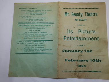 Kiewa Valley Historical Society
Mt Beauty Theatre Program, Mt Beauty Theatre - Picture Entertainment - January 1st to February 10th 1964
The Mt Beauty theatre was located in the community hall and gave residents access to the latest movies when television was just beginning to be a popular household entertainment. The Kiewa valley was for a very long time 'out of range' for television reception . Going to the theatre was popular for all age groups.This program shows that most of the films were suitable for the whole family.Mt Beauty entertainment consisted of going to the pictures on a Wednesday or Saturday night. Most films were suitable for the whole family and were up-to-date movies with well known stars. Thin greenish paper with dark green print folded making 4 pages detailing the schedule of the pictures to be shown.2 nights have been ticked.mt beauty theatre, films, pictures -
 Eltham District Historical Society Inc
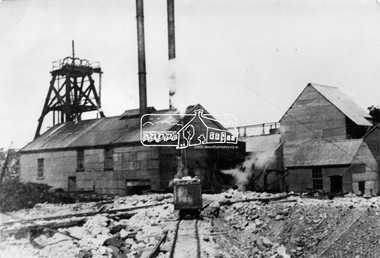
Photograph, Diamond Creek Gold Mine
Situated at the end of Fraser Street, Diamond Creek. The Diamond Creek Gold Mine was the largest in the Diamond Valley Shire with a shaft depth of over 290 metres at the peak of its development in 1915. The surface plant was quite large with four boilers and five steam engines working the battery, winder, water pump, air compressor and lighting generator.This photo forms part of a collection of photographs gathered by the Shire of Eltham for their centenary project book, "Pioneers and Painters: 100 years of the Shire of Eltham" by Alan Marshall (1971). The collection of over 500 images is held in partnership between Eltham District Historical Society and Yarra Plenty Regional Library (Eltham Library) and is now formally known as 'The Shire of Eltham Pioneers Photograph Collection.' It is significant in being the first community sourced collection representing the places and people of the Shire's first one hundred years.Digital imagesepp, shire of eltham pioneers photograph collection, diamond creek, goldmine, gold mine, poppet head -
 Eltham District Historical Society Inc
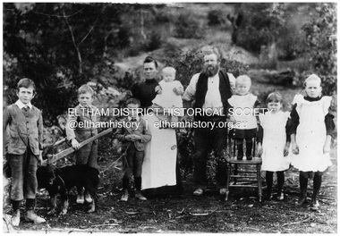
Negative - Photograph, Sabina and Will Mills and family, Upper Diamond Creek (Wattle Glen), c.1899
Sabina and William Henry Mills lived at "Golden Valley", Upper Diamond Creek (Wattle Glen) and had nine children in total. Here they are pictured with seven young children. Sabina died in 1916 aged 57 and William died in 1921 age 64. They are buried together at Diamond Creek (Nillumbik) cemetery. Reproduced on p46 of 'Pioneers & Painters'This photo forms part of a collection of photographs gathered by the Shire of Eltham for their centenary project book, "Pioneers and Painters: 100 years of the Shire of Eltham" by Alan Marshall (1971). The collection of over 500 images is held in partnership between Eltham District Historical Society and Yarra Plenty Regional Library (Eltham Library) and is now formally known as 'The Shire of Eltham Pioneers Photograph Collection.' It is significant in being the first community sourced collection representing the places and people of the Shire's first one hundred years.Digital image 4 x 5 inch B&W Neg 20 x 25 cm printsepp, shire of eltham pioneers photograph collection, wattle glen, sabina mills, will mills, mills family, pioneers and painters, upper diamond creek -
 Uniting Church Archives - Synod of Victoria
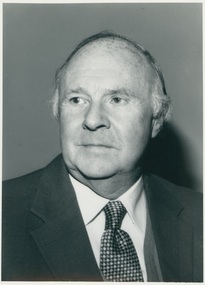
Photograph, c.1968
Rev. Ronald W. Allardice (1916-1990) was ordained in 1943 and was President of the Methodist Conference in 1968. After ordination Rev. Allardice went to Samoa, where he was Principal of the Piula Theological College. He was later District Chairman for Goulburn Valley. He was Managing Secretary of Conference 1974-1977 and he contributed to the formation of the Uniting Church.Black and white, gloss, head and shoulders portrait of the Rev. Ronald W. Allardicemethodist, alardice, ronald, president of conference, samoa, piula theological college, goulburn valley -
 Hume City Civic Collection
Photograph, 1/10/1978
On 4th August 1978 the construction of the Goonawarra Housing Estate commenced. The estate was formerly known as the Goonawarra Farm and overloked the Sunbury town area and Jacksons Creek valley. Plans for the new development included a gold course, housing, community and recreational facilities. The construction continued througout the last two decades of the twentieth century and into the twenty first century.A coloured photograph of the clubhouse taken from the south west at the Goonawarra Golf Club. The surrounding garden has been planted out with trees and has been mulched. A green car is on the LHS of the photograph.goonawarra farm, goonawarra golf club, goonawarra housing estate, sharkey, robert b., kilkenny homes, australian ideas homes pty.ltd., craftsmen homes., glamor homes, villa bella homes, george evans collection -
 Hume City Civic Collection
Photograph, 1/11/1980
On 4th August 1978 the construction of the Goonawarra Housing Estate commenced. The estate was formerly known as the Goonawarra Farm and overloked the Sunbury town area and Jacksons Creek valley. Plans for the new development included a gold course, housing, community and recreational facilities. The construction continued througout the last two decades of the twentieth century and into the twenty first century.A coloured photograph of Francis Boulevard at the Goonawarra Estate showing the entrances and landscaping and looking south to Sunbury Road and Jacksons Hill (Sheoak Hill).goonawarra farm, goonawarra golf club, goonawarra housing estate, kilkenny homes, craftsmen homes., australian ideas homes pty.ltd., villa bella homes, glamor homes, george evans collection -
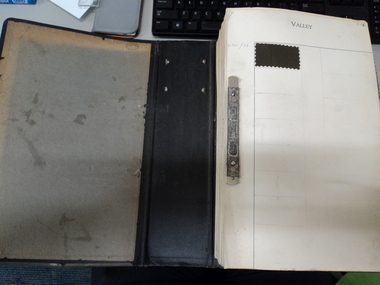 National Wool Museum
Reference book, Design reference register
A design reference folder containing cloth samples for future reference. When a new cloth design was created, a small sample would be cut and pasted into this folder, so that any future designs could be compared against it. Cloth samples were taken from cloths designed between 1960-1990 at the Valley Mill/John Foster.Solid black folder containing many pages, each with a number of small cloth samples on them.kanemutsa, code, sydney, japan, wool buying -
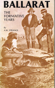 Otway Districts Historical Society
Book, B. & B. Strange, Ballarat: the formative years, April 1982
From 1838 early Ballarat was settled by pastoralists in ideal conditions, a peaceful, verdant valley where the hills were clothed in virgin forest and the flats covered with lush pasture. Then gold was discovered to spark off what was Victoria's first great gold rush. This book covers the gold rush after on the aboriginal ownership and early pastoral activities.Ballarat: the formative years. A.W. Strange. B. & B. Strange; Ballarat (Vic); April 1982. viii, 100 p.; illus.; map. Soft cover. ISBN 0 9596802 3 3Signed: "A.W. Strange 10/1/1983" Map inside back cover.ballarat; pastoralism; aborigines; gold rush; mining; eureka; local government; a.w. strange; -
 Sunbury Family History and Heritage Society Inc.
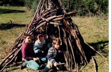
Photograph, Bulla Primary School, Gundiwindi School camp, 14th - 18th August 1989
The photograph was taken in 1989 when the children in grades 4 an 5 attended a school camp at Gundiwindi, which is in the Yarra Valley on the border of Wandin and Nth. Silvan. At the camp the children were acquainted with the skills used by the local indigenous people. The children the photograph attempted to construct a bark shelter along the lines of those build by the local indigenous people. While the children from Bulla Primary School attended the camp at Gundiwindi they were introduced to skills used by local indigenous people.A coloured non- digital photograph of three children sitting at the entrance of a primitive bark shelter. The immediate surrounding area has been cleared but native woodland is growing beyond the fence line. school camps, gundiwindi, bulla primary school, indigenous culture -
 Falls Creek Historical Society
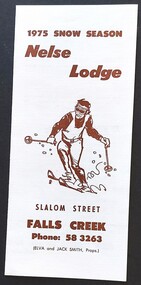
Booklet - Nelse Lodge, 1975
Nelse Lodge was established in Falls Creek c1958 probably by Des Crosser. It was later purchased by Bob Scott (Scotty). He was killed during a tragic accident during the construction of the Sun Valley T-bar. In 1973, Bob's widow sold Nelse Lodge to Jack and Elva Smith who were proprietors at the time this brochure was published.This brochure is significant because it is linked to one of the early lodges established in Falls Creek. A small brochure advertising Nelse Lodge, Falls Creek.It features a skier and brown text.1975 Snow Season Nelse Lodge Slalom Street FALLS CREEK Phone: 58 3263 (ELVA and JACK SMITH, Props)falls creek accommodation, nelse lodge, falls creek history -
 Parks Victoria - Gabo Island Lightstation
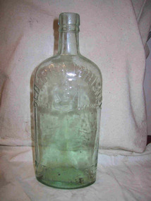
Bottle
The clear, green tinged bottle with lip, collar and high shoulder, has raised embossed information on the body indicating that this is an Irish whiskey bottle from Mitchell & Co., of Belfast. It formerly had a cork stopper. The Kiewa Valley Historical Society has one of the same bottles in its collection and estimates its date of manufacture to be the 1890s.Whatever their provenance, they have an association with an event or activity on Gabo Island and for this reason have second level contributory significance for their potential to yield information relating to the cultural history of the lightstation.Clear green glass bottle, narrow neck, rounded shoulders of body of bottle."Irish Whiskey / Mitchell & Co of Belfast Ltd" Trade mark picture of crown on front. -
 Sunbury Family History and Heritage Society Inc.
Postcard, John Sands Pty. Ltd, Emu Bottom
The homestead featured on the postcard is 'Emu Bottom', which is claimed to be Victoria's oldest homestead, although over the years sections of the homestead have had to be rebuilt as result of fires so little of the original materials remain in the building. The homestead was built by George Evans in the 1830s when he squatted on a tract of land in the Jacksons Creek valley in Sunbury. A non-digital coloured photograph in post card format of a single storey homestead with a timber shingle roof. A timber post and rail fence is across the front of the property. The post card has a crinkled edge.'emu bottom', george evans, homesteads, jacksons creek, sunbury -
 Kiewa Valley Historical Society
Photographs – Set of 9 black and white photographs and photocopies of original photographs depicting the early days of Bogong Village during the 1940’s, circa 1940's
Bogong Village, which was known as “The Junction”, is well recorded. The first tent camp was at the junction of Pretty Valley and Rocky Valley streams in the early 40’s. Further downstream were the sawmill, stables and blacksmith’s forge. Horses were the main mode of transport in the early days. The road to Bogong had reached the lookout spur just beyond Roper’s Spur track just before the 1939 fires. The early forties saw rapid growth of the village, with single and married men’s quarters, workshops, mess huts and administrative offices. The facilities necessary for communal living were quickly in place- a post office, police station, co-op store, medical centre, community hall/theatre, tennis courts and school. Much of the temporary accommodation that housed groups such as the Albion Quarrying Company were in the area now under water.Pictorial history of the early years of Bogong Village including one photo taken following the devastating fires of 1939. Photos show the terrain in which Bogong Village was built, the early construction used for the temporary buildings and the housing and the amount of infrastructure required to accommodate the needs of the residents of the area including workers, their families and other support staff. Set of 9 black and white photographs and photocopies of photographs depicting early buildings at Bogong Village . Photos show very early construction buildings as well as the village in various weather conditions, including snowing and after bush fires. (some official SECV photographs) 1. Bogong Village in heavy snow 2. Bogong Township during heavy snow (SECV Official Photo) 3. VIP Lodge at Bogong in the snow 4. Bogong Village - circa 1940’s 5. Bogong Village under street lights 6. Lewis Construction Camp (SECV Official Photo) 7. Albion Quarrying Co. Camp (SECV Official Photo) 8. Tent camp and early buildings following 1939 fires 9. Typical house – Bogong Village 1. Handwritten under photo – August 1948 2. Printed under photo: STATE ELECTRICITY COMMISSION OF VICTORIA Date: 25.8.48 Time: 9am No:K 4680 Kiewa Hydro-Electric Works. Bogong Township 3. Handwritten on back of photo- V.I.P. Lodge, Bogong 4 – 5. No markings 6. Printed under photo: STATE ELECTRICITY COMMISSION OF VICTORIA Date: 28.11.40 Time: 1.40pm No:K284 Kiewa Hydro-Electric Works. Lewis Construction Camp 7. Printed under photo: STATE ELECTRICITY COMMISSION OF VICTORIA Date: 11.1.41 Time: 10.40am No:K294 Kiewa Hydro-Electric Works. Albion Quarrying Co. Camp – Bogong. Handwritten on back of photo: On the floor of the present dam 8. No markings 9. Printed under photo: STATE ELECTRICITY COMMISSION OF VICTORIA Date: 11.1.46 Time: 1.23pm No:K2181 Kiewa Hydro-Electric Works. Bogong – Typical House bogong village; 1939 fires; kiewa hydro electric scheme; -
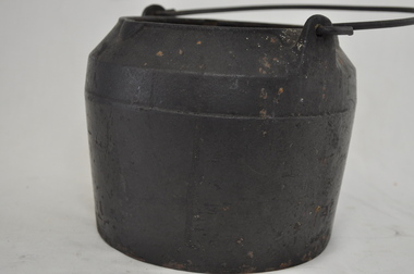 Kiewa Valley Historical Society
Pot Melting, circa mid to late 1900's
Before 1908 the words "melting pot" was a term relating to a "crucible" with a meaning of "a pot in which metals and other substances are melted (fused) to provide metal items of varying shapes and uses. From the mid 1900's this term changed and became more related to the "mixing" of social and ethnically diverse populations. The description used here is that of pre 1908. This melting pot was used in the early to late 1900's when produce and hardware shops were too far away from the Kiewa Valley and time was at the essence. The ability to manufacture as many "crucial " items at the home property was the difference between running a successful rural business or not. The isolation of the Kiewa Valley (before the 1950's), hindered the "time down" of machinery and important "widget" replacements. The ability of self sufficiency on properties is still a boon to rural properties as time lost is never really recovered.This melting pot is highly significant to the Kiewa Valley as it provides evidence that the graziers and cattle stations required to be self sufficient in all aspects of day to day maintenance and replenishment of worn materials requiring to be "manufactured " at the property and lack of replacements from commercially shelved products. This aspect of "survival" in the "bush" can be seen in the "huts" built on the Bogong High Plains to accommodate the seasonal grazing of cattle from the Kiewa Valley.This black melting pot is made of cast iron. The lid is missing. The top rim of the pot has three lips for poring accuracy. The formation of these lips are in a "triangle" formation. The top section of the body has a curve inwards reducing the pot diameter from 270mm at the base to 135mm.at the top. The handle is made from heavy gauge wire which is fastened to the body through two lugs (welded onto the top section of the pot) and fasten through a hole at the top of each lug. The handle has a "U" shape as it goes through the lug hole, ensuring no accidental fixture to any side thus allowing free swiveling from one side to the other . "BH" indented within a diamond shape. Opposite "No 3"camp fire cooking utensils, hot plate, cast iron cooking appliance, drovers kitchen