Showing 11125 items
matching planning
-
 Federation University Historical Collection
Book, Visitor Servicing Plan 2006 - Daylesford Region, 2006
Visitor Servicing Plan 2006 - Daylesford Region. Prepared by the University of Ballarat.White bound book of 26 pages.daylesford, university of ballarat, christine watts, rheanne hogema, kathy thomas, michael stevenson, mary hollick, overview of daylesford and accommodation services, professionalism of local industry, assessment of of information provision and its distribution internal to the destination, conclusions and recommendations, references, implementing visitor servicing plan, hepburn shire, tourism victoria, tourism -
Federation University Historical Collection
Book, Toni Woolley et al, Port Fairy Community and Organisational Plan, 1999
Port Fairy Community and Organisational Plan. University of Ballarat Students' Project.White bound book of 35 pages plus 6 appendices.port fairy, toni woolley, tamara lang, janelle gilbert, ben balshaw, grant caromody, executive summary, introduction, background to port fairy, methodology, limitations, appraisal of tourism planning and development to date, assessment of local community issues, attitudes and involvement in tourism, roles of local and regional tourism associations, effectiveness of local & regional tourism associations, analysis of services and service quality, moyne shire council, friends of port fairy, tourism victoria, country victoria tourism, great ocean road marketing, shipwreck coast tourism, port fairy tourism association inc, moyne shire, department of natural resources and environment, the western coastal board, tourism accreditation board of victoria, george borg, craig delahoy, michael hearn, jodie honan, judith kershaw, andrea lowenthal, neil martin, john ploenges, james purcell, peter strickland, mark thompson, libby wilson, michael pearlman, battle of the moyne, tourism planning, great ocean road -
Creswick Campus Historical Collection - University of Melbourne
Document, Management Plan for Mt.Beckworth Forest Reserve, c.1966
Hand typed loose covers Management Plan for Mt.Beckworth Forest ReserveDocument -
Creswick Campus Historical Collection - University of Melbourne
Book, Forests Commission of Victoria, Western Division. Outlines of management for all reserved forests in the Stawell Forest District, 1938
This is a typed document of a Stawell Working Plan for management of reserved forests 1938Document -
Creswick Campus Historical Collection - University of Melbourne
Book, Forests Commission of Victoria, Woohlpooer Management Plan, 1936
This is a typed document of a Woohlpooer Working Plan for management of reserved forests 1936Document -
Creswick Campus Historical Collection - University of Melbourne
Document, 1975
Contingency Working Plan - Victorian School of Forestry Hardwood Forest 1975Document -
 National Wool Museum
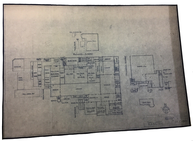
Archive - Architectural Plan, Plant Layout: R S & S Mill, 1973
Site plan of the R S & S Mill, 1st Dec, 1973.Architectural drawing on paper showing hand written diagrams and text. PE/C - 389textile mills - design textile mills - history, textile mills - design, textile mills - history, returned soldiers and sailors mill, r s & s mill, architecture, plan, site plan -
National Wool Museum
Plan
Floor plan designating office space in a woolstore, probably Dennys Lascelles.wool stores -
8th/13th Victorian Mounted Rifles Regimental Collection
Document, May 1987
This document sets out the plan for a years training by an Army Reserve Unit.Typed document setting out the training directive for ' A ' Squadron 8/13 Victorian Mounted Rifles for the training year 1987 - 1988. Eight pages, dated May 1987 and signed by Officer Commanding Major J. Gay. -
 Stawell Historical Society Inc
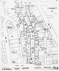
Photograph, Stawell Pedestrian Mall -- Proposed Plan and Concept drawing 1970
Stawell Pedestrian Mall. Proposed Plan and Concept drawing. Feb. 1970stawell -
 Lakes Entrance Historical Society
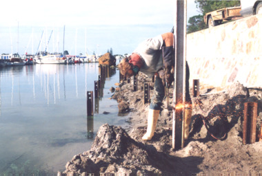
Photograph, Lakes Post Newspaper, Boardwalk Project Metung Victoria 1999, 1/02/1999 12:00:00 AM
Boats moored at marina in distance and Metung Rock beside planned boardwalkColour photograph showing Tim Edwards from Burys Slipway working on the foundations for the Boardwalk Project beside the lake at Metung Victoriawaterways, community organisation -
Glen Eira Historical Society
Document - Yeshivah & Beth Rivkah College
This file contains 2 items A Yeshiva and Beth Rivka Colleges and surrounds planning brief prepared by the City of Caulfield in consideration with the college and dated 1981 A Yeshiva and Beth Rivkah College incomplete planning brief dated 5th September 1988 with handwritten annotation and authored by AS: gobschools, local government, saint kilda east, independent schools, city of caulfield, building regulations, hotham street, yeshivah and beth rivkah college, plans, balaclava road, empress street -
 Bacchus Marsh & District Historical Society
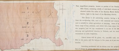
Map, Pentland Hills Estate Land Sale 1904
The Pentland Hills Estate property shown in this auction plan was put up for sale in 1904. It was a deceased estate sale. The property had been owned by Peter Grant who died in 1899. Peter Grant had worked and farmed in the Myrniong area for many years and had also been a Councillor on the Bacchus Marsh Shire for a number of terms. A property sales report in the Express newspaper recorded that the land for sale comprised 500 acres of the old Pentland Hills Estate. It was subdivided into three lots, all of which were sold at good prices. Lot l, 212 acres was sold to Messrs Thomas and Robert Lidgett of Myrniong, at £11/15/ per acre, lot 2, 200 acres, to Mr David Robertson, of Bacchus Marsh, at £9 17/0 per acre, and lot 3, 38 acres, was sold to Mr James Norton, jun at £11 per acre. A single page paper map showing a portions of land available for sale from the Pentland Hills Estate near Bacchus Marsh.The name of the seller, Mrs Grant, can seen handwritten on this map and the buyers of the three portions for sale, Lidgett lot 1, Robertson lot 2 and Morton lot 3. Parts of the text are missing along the edges due to tearing or excessive trimming of the edges. The map is pasted into a bound volume containing 76 maps or plans in total. High resolution digital image stored on BMDHS computer network. Handwritten: Mrs Grant, Myrniong, Executrix in the deceased Estate of Mr. Peter Grant to sell by public auction.land sales, pentland hills maps, myrniong area land sales, pentland hills estate -
 Bendigo Historical Society Inc.
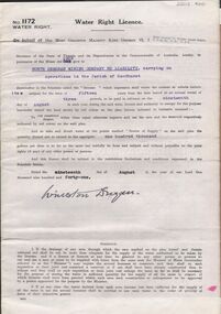
Document - MCCOLL, RANKIN AND STANISTREET COLLECTION: WATER RIGHT LICENCE NORTH DEBORAH MINING COMPANY NO LIABILITY, 19th August, 1941
4 page document plus map, Water Right Licence No. 1172, between King George VI ( the Crown ) and North Deborah Mining Company No Liability, Parish of Sandhurst., dated 19th August 1941. "to take and divert water at the points marked 'source of supply' on the said plan the quantity thereof not to exceed in the aggregate one hundred thousand gallons per diem' Plan: 'Mining District of Bendigo No. 1172 W.R., County of Bendigo, Parish of Sandhurst. Plan has dam area coloured in red, with pipe line drawn in red, leading from Battery marked on lease 11145 across lease 9988 to dam. Streets marked: Adams Road, Honeybone Street, Griston Street. (Golden Square area)bendigo, mining, north deborah mining company, north deborah mining company, adams, honeybone, and griston streets. (golden square) -
 Bendigo Historical Society Inc.
Document - Geological Survey of Victoria, Hustlers Line of Reef, Bendigo, April, 2014
Seven men were killed at the Great Extended Hustler's mine disaster on 2nd May 1914 by an explosion of dynamite occurring as the men were waiting at the plat to ascend the mine at the end of their shift. No blame was attached to anyone in the findings of the inquisition. It was unknown what caused the dynamite to explode. This document formed part of the research done at the time by Bendigo Historical Society, of the 100 years commemoration of the mine disaster, held at Hustler's Hill in 2014. Seven page photocopy of Department of Mines, Bulletin, Geological Survey of Victoria, Hustlers Line of Reef, Bendigo, No. 33 by H.S. Whitelaw. Includes plan of Hustlers Royal Reserve No. 2, (main shaft) showing location on Pall Mall, and location of Post Office and Law Courts; plan of location of Hustlers Royal Reserve No. 2 (Park Shaft) showing Jail (sic), Camp Hill State School, two 'lagoons' in between tennis court, croquet court and bowling green; a plan of the Great Extended Hustler's Shaft and two copied images of Hustler's Hill showing mining buildings, poppet heads and chimneys. Comet, K.K., Hustler's No. 1, Old Comet and United Hustler's and Redan Mines are shown in the images. great extended hustlers, goldmining, accident, quartz, mining, k.k. mine, comet mine, hustler's line of reef, old comet, united hustler's, redan -
Ballarat Tramway Museum
Document - Report, John Patrick Pty Ltd, "Ballarat Botanical Gardens Masterplan - Final Draft", Nov. 1995
Twelve page (7 A4 pages, 5 A3 folded pages), photocopied as the final draft of the Ballarat Botanical Gardens Masterplan November 1995. Prepared by Landscape Heritage Consultants, John Patrick Pty Ltd. Report stapled in the top left hand corner. Notes include references to the tramway facilities. The 5 A3 sheets show the proposed plan, including the tramway and an extension to the shed. See July 1995 Fares Please! for the plan itself.On page 1, words "Depot" and a hand written change to the date of display from "29" to "6".trams, tramways, wendouree parade, ballarat botanical gardens, tramways, masterplan -
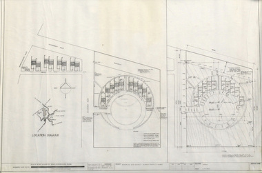
University of Melbourne, Burnley Campus Archives
Plan, Roh Cross, Lilydale Quarry Recreational Study for Landscape Studies, 1986
Plans on tracing paper and paper by Rob Cross Landscape Design. (1) Site Analysis No 1 dated 08.06.96. Scale 1:2400. (2.) Proposed Activity Zones No 2 dated 03.06.96. Scale 1:2400. (3) West Section of Valley No 3 dated 11.06.96. Scale 1:1000. (4) Concept Plan No 4 dated 11.06.96. Scale 1:2400. (5) Axonometric View No 5 dated 30.06.96. Scale 1:2400.lilydale, quarry, rob cross landscape design, landscape studies -
 Bendigo Historical Society Inc.
Document - STATE RIVERS AND WATER SUPPLY COMMISSION : GENERAL DESCRIPTION AND PARTICULARS OF EPPALOCK PROJECT, 1/08/1961
State Rivers and Water Supply Commission. Seven-page typed document titled 'General description and particulars of the Eppalock Project.' Subheadings: General, Administration and Works Installation, Field laboratory, Construction programme, Design statistics, Major items of plant in use on the project, Progress to 1st August 1961, Eppalock Reservoir Locality Plan (diagram), Eppalock project works area & arrangement plan (diagram), Eppalock Project cross section of dam along? tunnel (diagram).state infrastructure, water supply, coliban system, state rivers and water supply commission. coliban system. eppalock. -
University of Melbourne, Burnley Campus Archives
Plan, Como, 1983, 1993
(1) Como Plant Inventory: Rear of House - Big Pond Lawn, Fountain Terrace and The Paddock dated November 1983, Landform Australia - photocopy in 2 sheets. Numbered list of plants and placement. (2) 2 copies Blueprint - Automatic Watering System Legend by Planned Irrigation Projects Pty. Ltd. (3) Tracing paper and paper plans of Croquet Lawn and Pony Paddock 'Como', Como Avenue, South Yarra - Landscape Studies Assignment 1993.como house, plant inventory, south yarra, irrigation -
Ringwood and District Historical Society
Newspaper, Scrapbook Clipping, Library Collection, Ringwood, Victoria
Newspaper Clipping from "The Post", Tuesday August 12, 1997. Standard to Fall - Claim. By Peter Di SistoPlanned changes to Victoria's building regulations could result in lower building standards, Maroondah Council has warned. Maroondah Couincil's city services director, Lydia Wilson, last week tabled a a report on the likely impact of the changes -
 Eltham District Historical Society Inc
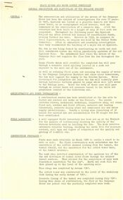
Book, Mark Tansley, Sites, Structures and Areas of Historical and Archaeological Significance, 1978
Prepared in partial fulfilment of the requirements of the Degree of Town and Regional Planning, University of Melbournesites, structures, archaeological significance, upper yarra valley, dandenong ranges -
 Greensborough Historical Society
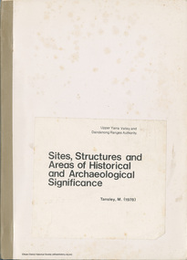
Newspaper clipping, Diamond Valley Leader, Anthony makes plans, 24/11/1987
Report on cancer patient Anthony Smith and his plans to overcome his illness.Photocopy of news article from Diamond Valley Leader (24/11/1987)anthony smith, cancer patients, watsonia football club -
 Eltham District Historical Society Inc
Photograph, Building Inspectors, Shire of Eltham, c.1989, 1989c
Building inspectors (Danny Hick on right) from the Shire of Eltham review plans.Roll of 35mm colour negative film, 6 stripsFuji 100council staff, eltham shire council, shire of eltham, building construction, building inspector, danny hick, infrastructure -
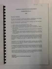 NMIT (Northern Melbourne Institute of TAFE)
Document, Marketing Plan: Corporate Communications Department 2002, 2002
This document outlines the Marketing Plan for NMIT in 2002, as proposed by the Corporate Communications Department.This document details plans for the marketing and promotion of NMIT.34 pages (approx.), printed on one side of paper. Spiral bound with clear plastic cover.corporate communications, marketing plan, nmit, -
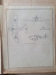 Moorabbin Air Museum
Drawing (item) - A variety of Aeroplanes Plans, Aeroplane Plans
Plans contain an array of aircraft, majority being from the Second World Warplans, ww2, second world war, mustang, commonwealth aircraft corporation, aircraft plans -
Tatura Irrigation & Wartime Camps Museum
Document, WW2 Internment and POW Camp
Various large photocopies of cartoons, plans, poems, review programme, newspaper articles.Large black plastic folder with 20 bound plastic sleevesWW2 Internment and POW Camps Tatura Group and Loveday Camp SAcamp 1; loveday camp, tatura group internment camp, loveday internees -
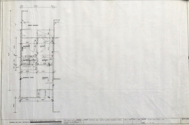
 Robin Boyd Foundation
Drawing - Architectural, Monbulk & District Elderly Peoples Homes, Feb-75
Project: drawn by Leslie Jones of Romberg & Boyd. Site Plan and Complex LayoutWorking Drawing, Ink on Tracing Paper -
 Robin Boyd Foundation
Drawing - Architectural, Monbulk & District Elderly Peoples Homes, Feb-75
Project: drawn by Leslie Jones of Romberg & Boyd. Site Plan and Complex LayoutWorking Drawing, Ink on Tracing Paper -
8th/13th Victorian Mounted Rifles Regimental Collection
Document - Admin Inst Anzac Day
Example of planning involve in regimental support to local communities in North East Victoria.Typed Administrative Instruction for 'A' Squadron 8/13 Victorian Mounted Rifles support to Anzac Day activities i local communities: Albury Benalla, Corowa, Cobram, Finley, Strathmerton and Tocumwal. Five pages including list of appointments.anzac day, wangaratta, cobram, benalla, corowa, finley, strathmerton, tocumwal, albury, vmr -
8th/13th Victorian Mounted Rifles Regimental Collection
Document - Beechworth Easter parade
Example of planning involved in local regimental support to communities in North East Victoria.Typed Administrative Instruction for ' A ' Squadron 8/13 Victorian Mounted Rifles Support to Beechworth Easter Parade and Harrietville Bi - Centennial Spectacular 2 - 3 April 1988. Eight Pages including Nominal Roll.8/13 victorian mounted rifles, bicenterary, beechworth, harrietville