Showing 4433 items
matching the point
-
 Eltham District Historical Society Inc
Photograph, Eltham, Potts Point, NSW
Copy of two colour photographs -
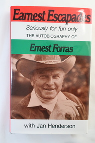 Kiewa Valley Historical Society
Book - The Autobiography of Ernest Forras, Earnest Escapades Seriously for fun only The autobiography of Ernest Forras with Jan Henderson
Ernest migrated from Hungary in January 1951 and helped bring commercial development to Australia's fledgling snowfields. He was keen to find Alpine employment, eventually importing ski and sports gear. This book covers his time in Hungary and his visits to the Alpine Ski Resorts - an insight into the early years of skiing in Australia.Ernest visited Falls Creek on the Bogong High Plains in 1951 and describes the area on pages 66 to76 from the point of view of an Hungarian migrant. He visited Falls Creek because his brother had got work on Kiewa Hydro Electric Ssheme.Hard dark brown cover book with dust cover coloured in red, white and green with title in black and a photo of Ernest Forras below. It consists of 190 pages. After page 54 and between Part one and Two, there are 18 pages of photos on photographic paper.Written in shaky writing on inside first page "To Debbie / From Hungary With Love / Ernest Forras 2002 / Mt Beautyernest forras, australian ski resorts from 1951, hungary pre 1951 -
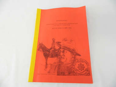 Kiewa Valley Historical Society
Book - Non Fiction History, Honour Roll - South Africa 1899 - 1902 Albury-Wodonga and District Residents Who Served In The Boer War, reprinted 03/2008
Historical information of soldiers from the Albury-Wodonga district who fought in the Boer War in South Africa 1899 - 1902. In 1996 the then curator for the 8/13 VMR Museum, the Hon Colonel John Neale, commissioned the author to research a group of returned servicemen and women from the Boer War and had lived within 100 km radius of the Albury/Wodonga townships.The Boer War was the second war in South Africa and was the result of heavy taxes and non voting rights of the local white Boer population. Colonial forces including the Australian Light Horse contingent where called upon by England to overthrow the rebellion. This War was the first engagement of Australian troops fighting on foreign soil.This Honour Roll details the pay rates, the battle highlights, weapons used and maps covering the first Australian contingent of soldiers who fought in the Transvaal (Boer War).. Listed are the names of those soldiers who lived within 100klms of Albury and Wodonga.The soldiers are listed by Location, Rank, Initial,Name and Unit. The significance of both the War and those who served in it is two fold. Firstly it demonstrates that the tie between the Colonial outreaches of England's Empire to "the Motherland" were extremely strong at this point in time. This union remained strong up until the middle of World War II when England could not help Australia to defend itself against possible invasion by Japan. The alliance between Australia and the United States of America replaced the British/Australian pact. Secondly the attitude of, and the high degree of horsemanship of those from the Albury and Wodonga area. The degree of adaptability, by these servicemen, to suit the environment in which they fought provided the first real insight into the Australian psyche "of those living and surviving on the harsh Australian outback"This book has a bright red soft cover and is bound with bright yellow tape. There is a drawing of two Australian soldiers on the front, one on horsebackAuthor's complimentary inscription "To Mount Beauty Museum with compliments" signed Ian R Docking history, boer war, ex-servicemen and women, albury and wodonga -
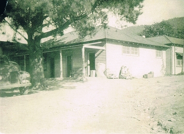 Kiewa Valley Historical Society
Photograph Tawonga Hotel, Tawonga Hotel Circa 1940s - 1950s, circa 1940s to 1950s
This photograph shows the "lay back" atmosphere enjoyed in a small country town in the 1940s to the 1950s. Two women and a young boy basking in the warmth of the sun. The unsealed drive way and cars parked close to the entrance was typical of small towns during this period. Open doors and shady trees provided sufficient cooling for most sunny days. The wooden barrel next to the outside wall shows that storage space within the hotel was limited and that metal aluminium barrels had not been in existence. This photograph was taken at a time when children and women had limited access to the major drinking and entertainment facilities within a hotel(pub). Legal drinking age was for patrons 21 years and older and no strict dress codes where applied. The hotel bar was not open on Sundays (God fearing) and opening time restrictions were in place. "In transit" clients were given some leniency when staying in small country hotels as strict liquor laws This photograph presents a window to a life in the 1940s to 1950s, of a small town in the Kiewa Valley. It covers a period when the local hotel or "pub" was the meeting point for local men and women to talk about local events and life in general. It was also a point where "locals' had the first opportunity to meet new arrivals and converse with tourists and "through traffic". The importance of "face to face" verbal communication was a critical part of community life and interaction. The hotel(pub) was in this period the hub of small communities, and together with local churches provided the essential structure for a balanced existence in rural Australia.Black and white photo of Tawonga Hotel. This photo is in itself a photo of a photo and as such lacks fine detail. This reproduction is on "Kodak XtraLife II paper ""outback" hotels, pubs, rural short stay accommodation, tawonga hotel -
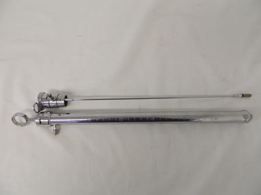 Kiewa Valley Historical Society
Sigmoidoscope Rigid, Mid to late 1900s
This item was used before the flexible sigmoidoscope (1996) and before the introduction of fibre optics late 1900s. The 1900s saw an incredible leap forward in the field of medical procedures. The ability to visually see what was happening within the human body (in real time) provided greater analysis about certain biological abnormalities during a greater time elapse than before. This procedure involved less trauma to the patient and greater flexibility to the Physician in treatment schemes. The rigid signoidscope, however provided the first visual of the colon in situ, but was highly invasive to the patient.This item was used in the Mount Beauty Hospital for qualified Physicians to use in their diagnostic evaluation of patients. This would not be an instrument used by a General Physician. This item is still a internal observatory method which may, in some instances, cause some minor complications. This item does point to the level of medical diagnostics, equivalent to those available in larger towns and cities, which brings this rural area (once considered to be an isolated region) to a higher level of medical care.This rigid 35 cm long sigmoidoscope (internal probe) is made of stainless steel outer hollowed rounded rod, which permits the use of both a fixed (very thin) lighting rod and two flexible cord lights access. Both the lighting rod and the flexible lights can be lowered within the main rod to allow the physician to see the colon at the bottom of the rod.These items are all contained within a specifically inlaid wooden box. The box has separate open compartments for the main instruments and a small lidded compartment containing replacement light bulbs. The hollowed tube permits the physician to visually observe the signoid (an S shaped part) of the colon.On the stainless steel main rod body are engraved the lengths of the body,in centimetres ,with numbers starting at the five centimeter mark and then every five centimetres up to the thirty centimetre mark. On the front inside rim of the box are two inlaid white plastic strips with black print, "ALLEN & HANBURYS Ltd" and the other "LONDON"medical diagnostics, sigmoidoscope examinations, medical examinations, hospital equipment -
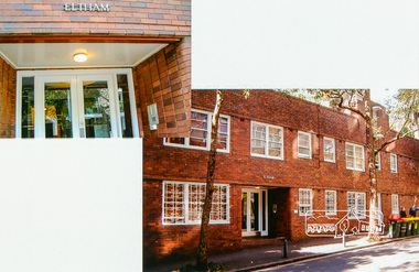
 Eltham District Historical Society Inc
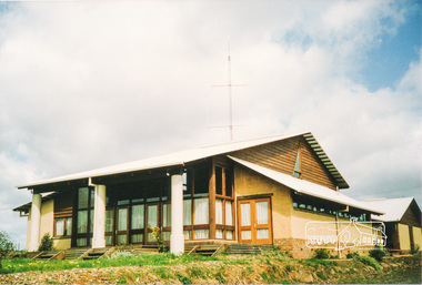
Photograph, Emergency Operations Centre, S.E.S., Kangaroo Ground
In 2017 known as the Kangaroo Ground Operations Centre a facility for hire managed by the Shire of Nillumbik. On 7 February 2009 (Black Saturday) the CFA Incident Control Centre (ICC) was located here. Described in "Worst of Days: Inside the black Saturday firestorm" by Karen Kissane (access via Google books): "..the ICC is part of a mud brick complex built in the 1980s as an emergency operations centre for several agencies, including the State Emergency Service. It is also home to the headquarters of the CFA's Lower Yarra Group. A small office with a whiteboard would be the incident controller's office throughout the office, but a larger central room, with data projectors, "smart boards" and maps would house the rest of the team.."Statement of Significance From the Victorian Heritage Database (2010) What is significant? The 1988 emergency operations centre and the surrounding site to the title boundaries. How is it significant? The emergency operations centre is architecturally, aesthetically, socially and historically significant to the Shire of Nillumbik. Why is it significant? The emergency operations centre is architecturally and historically significant as a good and rare example of a large public building constructed in a 1980s version of the 'Eltham style', and as a rare attempt to adapt the 'Eltham-style' aesthetic to meet the changing demands of the Shire in the 1980s (Criteria B, D & E). The emergency operations centre is architecturally and aesthetically significant because it is constructed of mud brick and features: a central entry with a tile mural (Criterion E). The emergency operations centre is socially significant because it is a focal point for the community and has played an important role in protecting the community since 1988 (Criterion G).Two colour photographs of mud brick Emergency Operations Centre building, Kangaroo Groundbuildings, mud brick, emergency centre, kangaroo ground -
 Warrnambool and District Historical Society Inc.
Map - An Angler's map of the Hopkins River Estuary, Angler's map Hopkins River, 1980s
This is a map of the Hopkins River Estuary prepared by Dr John Sherwood for the benefit of anglers. The information on the sheet includes the location of sand banks, the water depths, boat ramp facilities and public access facilities. Some of the information has been gathered from aerial photographs. The map has been produced by the Warrnambool Institute of Advanced Education which was developed in the late 1960s from the tertiary section of the Warrnambool Technical College and with all its departments established by 1984 at the Sherwood Campus five kilometres from Warrnambool on the Princes Highway. Today the site is occupied by Deakin University, Warrnambool campus. The Warrnambool Anglers’ Club has its headquarters on the banks of the Hopkins River near the mouth of the river and the Lyndoch Aged Care facility.This map is of interest as a specialist one, providing fishermen with detailed information on all aspects of the Hopkins river estuary. Fishing has been both a profession and a popular recreational pursuit for Warrnambool residents since the early days of the city’s settlement. The Hopkins River Estuary has been a focal point for fishermen throughout Warrnambool’s history. This is a sheet of paper folded three times to produce a folded map. The front cover has a black and white photograph of two fishermen with a large fish. The map of the Hopkins River Estuary is in yellow, blue and black and covers the side of one sheet and three quarters of the other side. There is an advertisement for the Hopkins River Boathouse with a black and white sketch of the boathouse and notes on the map written by Dr John Sherwood. There are several diagrams showing the water depths. The map has some silverfish damage and some tearing at the folds. warrnambool anglers’ club, history of warrnambool, hopkins river, hopkins river estuary, john sherwood -
 Warrnambool and District Historical Society Inc.
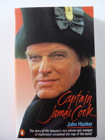
Book, Captain James Cook, 1987
This book, written by John Hooker, contains the story of Captain Cook based on the screenplay by Peter Yeldham for the A.B.C. television production of the life of Captain James Cook. The voyages of Captain Cook are of prime importance in Australia’s history as his discoveries and positive reports of the east coast of Australia led eventually to Britain’s decision to establish a penal colony in New South Wales.This book is of significance because it was written by John Hooker, important in Warrnambool’s late 20th century history as a regular feature writer and columnist for the Warrnambool Standard newspaper. His articles, which raised moral, social and political issues from a local point of view, were widely read and admired by the residents of Warrnambool and district. Born in New Zealand, John Hooker came to Australia in 1963 and resided for a time at Killarney near Port Fairy. He was a publisher and later a full-time writer, publishing both newspaper articles and novels. This is a soft cover book of 258 pages. The cover is mainly red and blue and features on the front cover a colour photograph of Keith Michell, the actor portraying Captain Cook in the A.B.C. film production. The back cover has a summary of the life of Captain Cook and a small colour photograph of a film scene of Captain Cook with some Pacific Islanders. The book has a Prologue, three chapters and an Epiloguejohn hooker, captain james cook, history of australia, warrnambool history -
 Warrnambool and District Historical Society Inc.
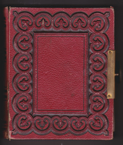
Album - Photo Album, Late 19th century
This album contains photos done on photographic paper while others are on exposed metal. Some are named, among them a Thomas or Edward Wickham, Fred Giles, Mrs. F Giles, Mary Humphrey Wickham, Jack Giles, Eliza Hornsby. Some of the photographs have been taken by Warrnambool photographers including Daniel Clarke. This album shows two different methods of photography which existed in the mid to late 19th century. With a number of the photos named it would suggest that there is some family connection between them which provokes an interest from a genealogical point of view. Red leather cover with circular pattern with black edging which sits around rectangle on front and back. Brass metal clasp. Pages are edged in gold. First pages has photo of woman leaning on back of couch and last page has cut out coloured picture of three children with garlands of flowers.Stamp inside front cover, Hider, Charles Liebig St, Warrnambool.warrnambool, photo album warrnambool, giles family album, 19th century album, giles, wickham, hornsby, daniel clarke -
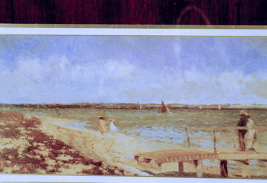 Eltham District Historical Society Inc
Photograph, Peter Bassett-Smith, Breezy day at Point Henry, near Geelong, Walter Withers (c. 1900), 1988
Bicentennial/Heritage Week Display, "The Eltham Tradition", Eltham Shire Office, 17-22 April 1988 Purchased by the NGV 1958 Colour photographactivities, eltham shire office, heritage display, heritage week, walter withers -
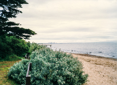 Eltham District Historical Society Inc
Photograph, Doug Orford, Melbourne from Point Cook, Spring Excursion to Steiglitz and Point Cook, 3 October 1993, 03/10/1993
Colour photographactivities, point cook -
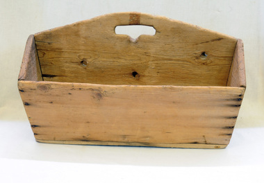 Orbost & District Historical Society
cutlery box, Jensen, Peter, Early 20th century
Made for Danebo Guest House at Martin's Creek. Peter Jensen came to Martin's Creek (35 miles north of Orbost) in 1890 having been told that Martin's Creek would be on the railway line. He was a cooper who made the casks from silver wattles. He cleared the area for farming and then built an accommodation house, Danebo., which was well used by travellers to Bonang and Bendoc. Gippsland was a relatively less developed part of Victoria in the nineteenth century. Danebo Hotel, Martin’s Creek, would have been an important stopping point for travellers to Bonang and Bendoc. The hotel is no longer standing.A open rectangular shaped wooden cutlery box - probably hand-made.. It has a carrying handle cut into the divider.jensen-peter martin's-creek danebo cutlery-box container -
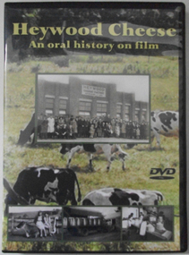 Cheese World Museum
DVD, Heywood Cheese; an oral history on film
For many years the Heywood Cheese Factory was an important part of life for Heywood and district farming and a vital place of employment for up to 40 men and 10 women. The factory opened in 1939 as a subsidiary of the Portland Butter Factory before becoming a world renowned cheese making enterprise. It was felt important to document its history from the surviving factory workers, including dairy suppliers and milk truck drivers. We hear their stories of the long hours and hard work without penalty rates, travelling unsealed roads and mixed with their humour of the bygone days is an important acknowledgement of that era. [blurb on back cover]This oral history provides significant material relating to the dairy industry in south west Victoria during the mid 20th century. The interviews give first-hand recollections of the interviewees involvement in the industry from a point of view of factory workers, milk pick-up drivers and farmers.Full colour DVD cover has photograph of Heywood Cheese factory and photographs of girls with calves, milk cans on a truck and workers in the cheese room, superimposed on a photograph of dairy cows grazing in a paddock. The DVD has the photograph of the cows grazing in the paddock.Heywood Cheese/An oral history on film (front) For many years Heywood Cheese Factory was ... [see historical information] Edited by Garry Kerr for the Heywood Pioneer Wagon Shed/ Museum History Group who wish to gratefully acknowledge the/ support of the Victorian Government and Public Records Office/ Victoria for making this project possible. Duration: 70 minutesallansford, heywood, cheese factories, cheese manufacturing, dairying, cheese -
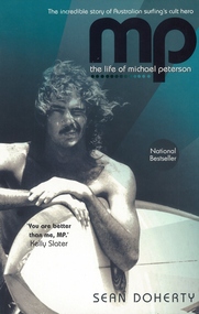 Australian National Surfing Museum
Book, Sean Doherty, MP - the life of Michael Peterson
For three years during the 1970's, 'MP' was the best surfer in the world, winning every surfing contest he entered. MP was an enigmatic competitor and master surfboard shaper during this significant period of growth and opportunity in Australian surfing.This biography tells the story of one of the most dynamic surfer/shapers in Australia during the 1970's. His contribution to world surfing is significant in both the contest arena and the shaping bay. Soft cover book featuring a photograph by Marty Tullemans of Michael Peterson with one of his surfboards under his arm. Quote from Kelly Slater. 342 pages.ISBN - 978 0 7322 8588 3michael peterson, bells beach, peter drouyn, mark richards, sean doherty, rabbit bartholomew, coolangatta, kirra point -
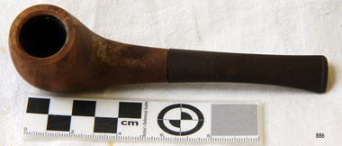 Flagstaff Hill Maritime Museum and Village
Leisure object, Tobacco Pipe, Early 20th century
People in ancient civilisations smoked pipes during various healing and religious ceremonies. By the end of the 15th century, after tobacco was discovered in America, smoking had become a common pastime for everyday people. From that time, tobacco pipes were fashioned from many materials ranging from gold and silver to corn cobs and clay. A popular material was meerschaum, an expensive, soft, white stone from Turkey. In the 1820s, French craftsmen carved pipes out of the wood from the growth on the root of a Mediterranean White Heath. This material became increasingly popular due to its durable, heat-resistant qualities. The growth was called ‘bruyere’, now anglicised to ‘briar’ wood. Bakelite was the first plastic made from synthetic components. It was developed by Leo Baekeland of New York in 1907. The material was heat-resistant and could be moulded into any shape and hardened to keep its shape. This invention greatly impacted the industrial world and the products available to the domestic market, making more objects available at reduced cost.This smoker's tobacco pipe symbolises one of the leisure activities of the early 20th century that has continued into modern times. The shape and materials of the pipe represent a point in time in the evolution of tobacco pipes, including the revolutionary impact that the 1900s invention of Bakelite had on objects available in the domestic and industrial markets.Smoker's tobacco pipe; a round brown wooden pipe bowl joined to a dark brown mouthpiece. The French pipe's bowl is made from briar wood, and its mouthpiece is Bakelite. There is an inscription on the pipe."French Briar Pipe"warrnambool, shipwreck coast, flagstaff hill, flagstaff hill maritime museum, flagstaff hill maritime village, smoker's pipe, tobacco pipe, briar wood pipe, wooden pipe, smoking, french pipe, bakelite, smoker's equipment -
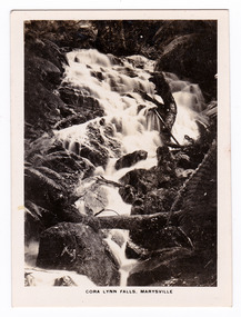
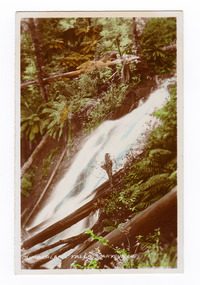
 Marysville & District Historical Society
Photograph (item) - Black and white photograph, Rose Stereograph Company, Track to Cora Lynn Falls, Marysville, 1913-1967
An early black and white photograph of the track to the Cora Lynn Falls in Marysville, Victoria.An early black and white photograph of the track to the Cora Lynn Falls in Marysville in Victoria. These falls are located on the Marysville-Wood's Point Road. Cambarville is notable for its giant mountain ash (Eucalyptus regnans) trees within the Cumberland Memorial Scenic Reserve, and relics from former sawmills and gold mining. The Big Culvert is located nearby on the Marysville - Woods Point Road, which was historically part of the Yarra Track. Cambarville was established as a timber mill town in the 1940s. Timber mill owners A Cameron and FJ Barton named Cambarville. They established the mill to salvage timber from trees destroyed in the 1939 bushfires. Cambarville was impacted by the 2009 Black Saturday bushfires and any remaining structures were destroyed. The photograph was also used to produce the Rose Series postcard P. 4958.marysville, victoria, photograph, cora lynn falls, waterfalls, p. 4958, rose series postcard, rose stereograph company, souvenir, cambarville, marysville-wood's point road, eucalyptus regnans, cumberland memorial scenic reserve, mining, big culvert, yarra track, a cameron, fj barton, 1939 bushfires, 2009 black saturday bushfires, timber mills -
 Marysville & District Historical Society
Photograph (item) - Black and white photograph, Rose Stereograph Company, Cora Lynn Falls, Marysville, 1913-1967
An early black and white photograph of the Cora Lynn Falls near Marysville in Victoria.An early black and white photograph of the Cora Lynn Falls near Marysville in Victoria. These falls are located on the Marysville-Wood's Point Road. Cambarville is notable for its giant mountain ash (Eucalyptus regnans) trees within the Cumberland Memorial Scenic Reserve, and relics from former sawmills and gold mining. The Big Culvert is located nearby on the Marysville - Woods Point Road, which was historically part of the Yarra Track. Cambarville was established as a timber mill town in the 1940s. Timber mill owners A Cameron and FJ Barton named Cambarville. They established the mill to salvage timber from trees destroyed in the 1939 bushfires. Cambarville was impacted by the 2009 Black Saturday bushfires and any remaining structures were destroyed. The photograph was also used to produce the Rose Series postcard P. 4947.marysville, victoria, photograph, cora lynn falls, waterfalls, rose series postcard, rose stereograph company, souvenir, cambarville, marysville-wood's point road, eucalyptus regnans, cumberland memorial scenic reserve, mining, big culvert, yarra track, a cameron, fj barton, 1939 bushfires, 2009 black saturday bushfires, timber mills, p. 4947 -
 Marysville & District Historical Society
Photograph (item) - Black and white photographs, Valentine Publishing Co. Pty. Ltd, Marysville, Vic, 1923-1963
A series of black and white photographs of scenic attractions taken in and around Marysville in Victoria that was published by the Barton Bros, Marysville and printed by Valentines Publishing Co as a souvenir of Marysville.A series of black and white photographs of scenic attractions taken in and around Marysville in Victoria that was published by the Barton Bros, Marysville and printed by Valentines Publishing Co as a souvenir of Marysville. Thomas Barton was one of the earliest settlers in Marysville and with 16 children and numerous descendants the name of Barton is synonymous with Marysville. Thomas John Barton, along with his business partner, Ewen Hugh Cameron, opened a butcher/abattoirs in Marysville in 1864. This was the first shop in Marysville. They supplied meat and other items to the miners along the Woods Point road. Thomas Barton was an active community member and was a key organiser in setting up the school in Marysville in 1870. After Thomas' death in 1911, his sons Fred and Frank took over the family business and renamed it Barton Bros. the road to cumberland valley (image 1), taggerty river (image 2), the acheron way (image 3), the old ford (image 4), nicholl's lookout (image 5), main street (image 6), mount margaret (image 7), stevenson falls (image 8), cumberland falls (image 9), keppel's falls (image 10), acheron way (image 11), marysville, victoria, barton bros, souvenir, valentine publishing co, thomas john barton, ewen hugh cameron, francis adam barton, frederick barton -
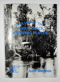 Marysville & District Historical Society
Book, The Last of the Yarra Track Stopping Places, 1980
A history of the stopping points on the Yarra TrackPaperback. Front cover has a black and white photograph of a wagon being pulled by two horses which have stopped to drink from a wide river. The back cover has a black and white photograph of an area of snow with a snow covered bush in the foreground.Sticker on front cover / Revised / Edition Stamp of Marysville & District / Historical Society Inc / P.O. Box 22 / Marysville 3779marysville, yarra glen, wood's point, history, yarra track -
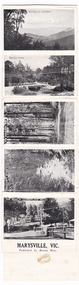
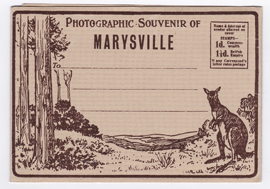 Marysville & District Historical Society
Postcard (item) - Black and white photographs, Barton Bros, Photographic Souvenir of Marysville, 1923-1963
A series of nine black and white photographs of scenic attractions taken in and around Marysville in Victoria that was published by the Barton Bros, Marysville and printed by Valentines Publishing Co as a souvenir of Marysville.A series of nine black and white photographs of scenic attractions taken in and around Marysville in Victoria that was published by the Barton Bros, Marysville, and printed by Valentines Publishing Co as a souvenir of Marysville. Thomas Barton was one of the earliest settlers in Marysville and with 16 children and numerous descendants, the name of Barton is synonymous with Marysville. Thomas John Barton, along with his business partner, Ewen Hugh Cameron, opened a butcher/abattoirs in Marysville in 1864. This was the first shop in Marysville. They supplied meat and other items to the miners along the Woods Point road. Thomas Barton was an active community member and was a key organiser in setting up the school in Marysville in 1870. After Thomas' death in 1911, his sons Fred and Frank took over the family business and renamed it Barton Bros. Name & Address of/ sender allowed on/ cover STAMPS-/ 1d. Common-wealth/ 1 1/2d. British Empire If any Correspond'e/ letter rates postage From Published by BARTON BROS., Marysvillemarysville, victoria, barton bros, acheron way (image 1), keppel's falls (image 2), cumberland falls (image 3), stevenson falls (image 4), taggerty river (image 5), mount margaret (image 6), mount gordan (image 7), nicholl's lookout (image 8), the old ford (image 9), valentine publishing co, souvenir, postcard, thomas barton, ewen hugh cameron, francis adam barton, frederick barton -
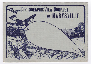 Marysville & District Historical Society
Postcard (item) - Black and white photographs, Barton Bros, Photographic View Booklet of MARYSVILLE, 1923-1963
A series of nine black and white photographs of scenic attractions taken in and around Marysville in Victoria that was published by the Barton Bros, Marysville and printed by Valentines Publishing Co as a souvenir of Marysville.A series of black and white photographs of scenic attractions taken in and around Marysville in Victoria that was published by the Barton Bros, Marysville and printed by Valentines Publishing Co as a souvenir of Marysville. Thomas Barton was one of the earliest settlers in Marysville and with 16 children and numerous descendants, the name of Barton is synonymous with Marysville. Thomas John Barton, along with his business partner, Ewen Hugh Cameron, opened a butcher/abattoirs in Marysville in 1864. This was the first shop in Marysville. They supplied meat and other items to the miners along the Woods Point road. Thomas Barton was an active community member and was a key organiser in setting up the school in Marysville in 1870. After Thomas' death in 1911, his sons Fred and Frank took over the family business and renamed it Barton Bros. To From Published by BARTON BROS., Marysvillemarysville, victoria, barton bros, acheron way (image 1), keppel's falls (image 2), cumberland falls (image 3), stevenson falls (image 4), taggerty river (image 5), mount margaret (image 6), mount gordan (image 7), nicholl's lookout (image 8), the old ford (image 9), postcard, valentine publishing co, souvenir, thomas barton, francis adam barton, frederick barton, ewen hugh cameron -
 Marysville & District Historical Society
Photograph (item) - Colour tinted photograph, Valentine Publishing Co. Pty. Ltd, Cumberland Falls, Marysville. No.3, 1923-1963
An early colour tinted photograph of the Cumberland Falls near Marysville in Victoria. This photograph was published by the Valentine Publishing Co Pty. Ltd. as a souvenir of Marysville.An early colour tinted photograph of the Cumberland Falls near Marysville in Victoria. These falls are located on the Marysville-Wood's Point Road. Cambarville is notable for its giant mountain ash (Eucalyptus regnans) trees within the Cumberland Memorial Scenic Reserve, and relics from former sawmills and gold mining. The Big Culvert is located nearby on the Marysville-Woods Point Road, which was historically part of the Yarra Track. Cambarville was established as a timber mill town in the 1940s. Timber mill owners A Cameron and FJ Barton named Cambarville. They established the mill to salvage timber from trees destroyed in the 1939 bushfires. Cambarville was impacted by the 2009 Black Saturday bushfires and any remaining structures were destroyed.cumberland falls, waterfalls, marysville, victoria, valentine publishing co, souvenir, a cameron, fj barton, cambarville, marysville-wood's point road, eucalyptus regnans, big culvert, yarra track, timber milling, 1939 bushfires, black saturday bushfires -
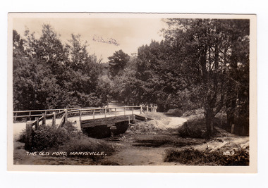 Marysville & District Historical Society
Photograph (item) - Black and white photograph, Valentine Publishing Co. Pty. Ltd, The Old Ford, Marysville No.9, 1923-1963
An early black and white photograph of the old ford in Marysville, Victoria.An early photograph of the bridge at the end of the main street in Marysville which is near the Buxton-Marysville Road and the Marysville-Wood's Point Road intersection. The Marysville-Buxton Road joins the Maroondah Highway which leads to Alexandra. The Marysville-Woods Point Road was originally part of the Yarra Track, constructed in the early 1860s to provide access between Healesville and the Woods Point Goldfields. Despite the steep terrain and engineering difficulties, the Yarra Track soon became a busy route used by pack horses, horse-drawn drays, and wagons. Today this sealed mountain road is a popular scenic drive between Marysville and Warburton. This photograph was published by the Valentine Publishing Co Pty. Ltd as a souvenir of Marysville.marysville, victoria, valentine publishing co, souvenir, buxton-marysville road, marysville-wood's point road, maroondah highway, alexandra, yarra track, mining -
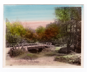 Marysville & District Historical Society
Photograph (item) - Colour tinted photograph, Valentine Publishing Co. Pty. Ltd, The Old Ford, Marysville No.9, 1923-1963
An early colour tinted photograph of the old ford in Marysville, Victoria. This photograph was published by the Valentine Publishing Co Pty. Ltd. as a souvenir of Marysville.An early photograph of the bridge at the end of the main street in Marysville which is near the Buxton-Marysville Road and the Marysville-Wood's Point Road intersection. The Marysville-Buxton Road joins the Maroondah Highway which leads to Alexandra. The Marysville-Woods Point Road was originally part of the Yarra Track, constructed in the early 1860s to provide access between Healesville and the Woods Point Goldfields. Despite the steep terrain and engineering difficulties, the Yarra Track soon became a busy route used by pack horses, horse-drawn drays, and wagons. Today this sealed mountain road is a popular scenic drive between Marysville and Warburton. This photograph was published by the Valentine Publishing Co Pty. Ltd as a souvenir of Marysville.marysville, victoria, valentine publishing co, souvenir, buxton-marysville road, marysville-wood's point road, maroondah highway, alexandra, yarra track, mining -
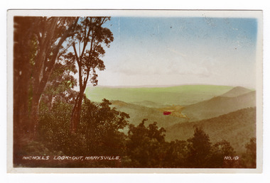 Marysville & District Historical Society
Photograph (item) - Colour tinted photograph, Valentine Publishing Co. Pty. Ltd, Nicoll's Lookout, Marysville No.10, 1923-1963
An early colour tinted photograph of Nicholl's Look-out near Marysville in Victoria. This photograph was published by the Valentine Publishing Co Pty. Ltd. as a souvenir of Marysville.An early colour tinted photograph of Nicholl's Look-out near Marysville in Victoria. This lookout is situated on the Marysville-Wood's Point Road. The Marysville-Woods Point Road was originally part of the Yarra Track, constructed in the early 1860s to provide access between Healesville and the Woods Point Goldfields. Despite the steep terrain and engineering difficulties, the Yarra Track soon became a busy route used by pack horses, horse-drawn drays, and wagons. Today this sealed mountain road is a popular scenic drive between Marysville and Warburton. This photograph was published by the Valentine Publishing Co Pty. Ltd. as a souvenir of Marysville.marysville, victoria, valentine publishing co, souvenir, nicholl's look-out, mining, yarra track -
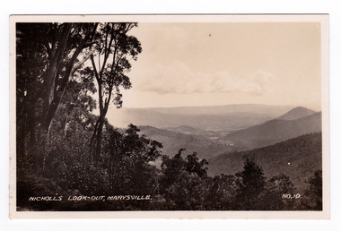 Marysville & District Historical Society
Photograph (item) - Black and white photograph, Valentine Publishing Co. Pty. Ltd, Nicoll's Lookout, Marysville No.10, 1923-1963
An early black and white photograph of Nicholl's Look-out near Marysville in Victoria.An early black and white photograph of Nicholl's Look-out near Marysville in Victoria. This lookout is situated on the Marysville-Wood's Point Road. The Marysville-Woods Point Road was originally part of the Yarra Track, constructed in the early 1860s to provide access between Healesville and the Woods Point Goldfields. Despite the steep terrain and engineering difficulties, the Yarra Track soon became a busy route used by pack horses, horse-drawn drays, and wagons. Today this sealed mountain road is a popular scenic drive between Marysville and Warburton. This photograph was published by the Valentine Publishing Co Pty. Ltd. as a souvenir of Marysville.marysville, victoria, valentine publishing co, souvenir, nicholl's look-out, mining, yarra track -
 Marysville & District Historical Society
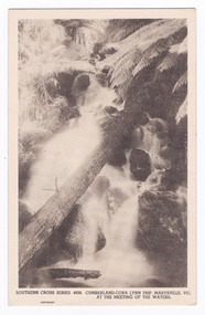
Postcard (item) - Black and white postcard, Rose Stereograph Company, Cumberland-Cora Lynn Trip, Marysville, Vic. At the Meeting of the Waters, 1913-1967
A postcard in a series produced by the Rose Stereograph Company in Victoria, Australia.A black and white photograph of the Cora-Lynn waterfalls at the Meeting of the Waters near the Cumberland Creek. These falls are located on the Marysville-Wood's Point Road. Cambarville is notable for its giant mountain ash (Eucalyptus regnans) trees within the Cumberland Memorial Scenic Reserve, and relics from former sawmills and gold mining. The Big Culvert is located nearby on the Marysville-Woods Point Road, which was historically part of the Yarra Track. Cambarville was established as a timber mill town in the 1940s. Timber mill owners A Cameron and FJ Barton named Cambarville. They established the mill to salvage timber from trees destroyed in the 1939 bushfires. Cambarville was impacted by the 2009 Black Saturday bushfires and any remaining structures were destroyed. This postcard was produced by the Rose Stereograph Company as a souvenir of Marysville.POST CARD. Correspondence/ Addresscora lynn falls, waterfalls, cumberland valley, cumberland creek, marysville, victoria, southern cross series, 4938, postcard, souvenir, meeting of the waters, marysville-wood's point road, cambarville, eucalyptus regnans, big culvert, cumberland memorial scenic reserve, a cameron, fj barton, 1939 bushfires, 2009 black saturday bushfires, rose stereograph company -
 Marysville & District Historical Society
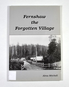
Book - Paperback book, Alma Mitchell, Fernshaw the Forgotten Village, 2001
The story of the village of Fernshaw between the dates of 1864 and 1890.Paperback. Front cover has the title and author's name. Also, a black and white photograph taken by John W. Lindt entitled 'First Glimpse of Fernshaw'.non-fictionThe story of the village of Fernshaw between the dates of 1864 and 1890.fernshaw, victoria, history, watts river, yarra track -
 Marysville & District Historical Society
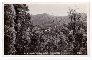
Postcard (item) - Black and white postcard, Valentine Publishing Co. Pty. Ltd, View From Jock's Lookout, Marysville. V. 21, 1923-1963
An early black and white photograph of the view from Jock's Lookout of Marysville in Victoria. An early black and white photograph of the view from Jock's Lookout of Marysville in Victoria. Jock's Lookout is situated on the Marysville-Wood's Point Road. The Marysville-Woods Point Road was originally part of the Yarra Track, constructed in the early 1860s to provide access between Healesville and the Woods Point Goldfields. Despite the steep terrain and engineering difficulties, the Yarra Track soon became a busy route used by pack horses, horse-drawn drays, and wagons. Today this sealed mountain road is a popular scenic drive between Marysville and Warburton. This postcard was published by the Valentine Publishing Co. Pty. Ltd. as a souvenir of Marysville.VALENTINE'S/ POST CARD/ A GENUINE PHOTOGRAPHjock's lookout, marysville, victoria, postcard, valentine publishing co, souvenir, marysville-wood's point road, yarra track, mining, warburton -
 Marysville & District Historical Society
Postcard (item) - Black and white postcard, Valentine Publishing Co. Pty. Ltd, View From Jock's Lookout, Marysville. V. 21, 1923-1963
An early black and white photograph of the view from Jock's Lookout of Marysville in Victoria.An early black and white photograph of the view from Jock's Lookout of Marysville in Victoria. Jock's Lookout is situated on the Marysville-Wood's Point Road. The Marysville-Woods Point Road was originally part of the Yarra Track, constructed in the early 1860s to provide access between Healesville and the Woods Point Goldfields. Despite the steep terrain and engineering difficulties, the Yarra Track soon became a busy route used by pack horses, horse-drawn drays, and wagons. Today this sealed mountain road is a popular scenic drive between Marysville and Warburton. This postcard was published by the Valentine Publishing Co. Pty. Ltd. as a souvenir of Marysville.VALENTINE'S/ POST CARD/ A GENUINE PHOTOGRAPHjock's lookout, marysville, victoria, postcard, valentine publishing co, souvenir, marysville-wood's point road, yarra track, mining, warburton