Showing 10952 items matching " land"
-
 Orbost & District Historical Society
Painting, Cameron, Grace (Miss), Circa 1920-1930
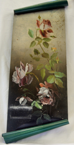
Grace Cameron was the daughter of John Cameron who selected the first land on the Snowy River flats. She was the sister of Annie (later Mrs John Gilbert) who was the first white girl born in Orbost.This item is aesthetically significant and shows the skill and craftmanship of the women of the early settler families.Large oblong oil painting on green painted tin with the top and bottom rolled for decoration. Painting of three single petalled pink roses in full bloom with two small buds.tin painting cameron-grace art -
 Orbost & District Historical Society
tie pin, 1890
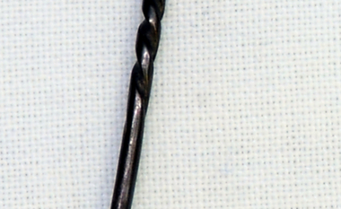
Gold nugget was found by the father of Lynch, Ray (Mr.) who was Mat Lynch. Nugget was found at McKenzie River in 1890.Matthew Lynch (1861-1939) was a snagger. Selected land at Brodribb. Gold prospector.This item, as well as having an aesthetic significance, is representative of the gold mining activities in East Gippsland.Handmade metallic tie pin with small gold nugget on top.tiepin costume accessories gold-nugget lynch-matthew -
 Federation University Historical Collection
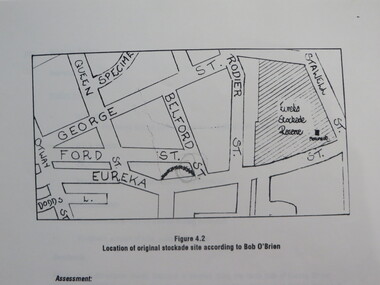
Report, Concept Study for the Further Development of the Eureka Stockade Reserve Conservation Plan, Vol 3, c1992
The objectives of the study were to * gather historical data and confirm the cultural significance of the site and reserve. * review existing site conditions including ownership together with current and proposed land uses. * Eureka Stockade location Copy of a 38 page report called "Concept Study for the Further Development of the Eureka Stockade Reserve Conservation Plan Vol 3", published by Ballarat University College. Authors are not stated. eureka, eureka stockade, ballarat university college, bert strange, bob o'brien, weston bate, alec barnett, jack chisholm, lloyd jenkins, eureka stockade location, cultural significance, eureka stockade site -
 Kinglake Historical Society
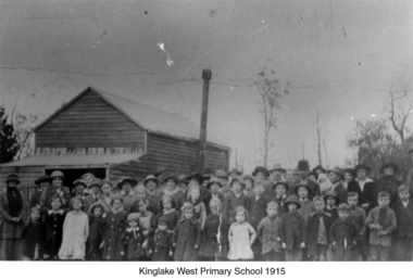
Kinglake West Primary School
Photograph of original Kinglake West Primary (State) School building with children and families. School built in 1896 by the pioneering families as Education Department would not build a school. Built on land selected by the Snell family.Only known photograph of the original school buildingPhotograph of original Kinglake West Primary School building education, school, pioneers, kinglake west -
 Peterborough History Group
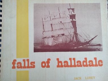
Book, Jack Loney, Falls of Halladale
Falls of Halladale wrecked to the West of Peterborough and the rocky point of land is now named Halladale Point. the book includes information about the history of the ship and photos of her in action, as well as information and photos of the wreck.Jack Loney researched and wrote a number of books about many shipwrecks along the Victorian coast. This limited edition book summarises the history of the barque Falls of Halladale, which wrecked just to the west of Peterborough and includes interesting photos of the ship at sail and as a wreck on the reef.A3 landscape style spiral bound book with stiff, cardboard pages. Limited editionInside it is noted that this is copy number 452 of 1000 copies, and is signed by the author. Also inscribed in pencil is " Donated by Barry Jenkins"shipwrecks, peterborough, falls of halladale, jack loney -
 Whitehorse Historical Society Inc.
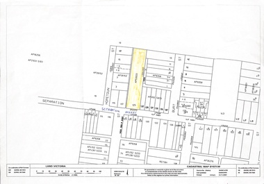
Map, 125 Separation Street, Northcote. Cadastral Map, 21/11/2001
A3 Cadastral Map of 125 Separation Street, Northcote August Schwerkolt purchased this property on 01/08/1853 where he lived and farmed the land, eventually purchasing the Mitcham property as well in 1861An A3 cadastral mapschwerkolt august -
 Bialik College
Scrapbooks, Student work
Scrapbooks of student work, including 'The Beginning', 'Land Reclamation', 'Planting Trees', 'Good Farming', 'Planning and Roads', c. 1980s and a booklet of poetry, 1984. Please contact [email protected] to request access to this record.student work, poetry, 1980s -
 Buninyong & District Historical Society
Photograph - B/W photograph, St. Alban's Cottage c 1873, former home of Dr. Sparling, July 1993
Built around 1873 by Dr. Sparling, on land formerly occupied by the first Buninyong Inn (aka Jamieson's Hotel). Some materials from the demolished hotel may have been used in building the house.Good example of 1870's professional residence, links to prominent citizen Dr Sparling.B/W Photograph, Polychrome brick cottage, L-fronted with bullnose verandah, on bluestone foundations with low bluestone fence. Signs "Buninyong Antiques" (under verandah) and "Antiques" on front of building.buninyong, sparling, jamieson, house, brick -
 Kew Historical Society Inc
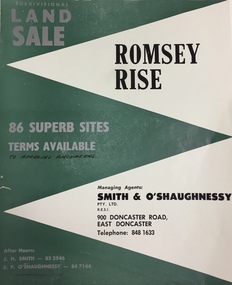
Plan - Subdivision Plan, Romsey Rise, Doncaster East
Real estate brochure for a land sale of 86 sites in East Doncaster. Roads identified in the plan include: George Street, Dennert Street, Worthing Avenue, Sandhurst Street, Belinda Crescent, and Romsey Rise.Historic subdivision plan of a Doncaster East EstateFour page colour real estate brochure including on page 2 a subdivision plan for the Romsey Rise estate in East Doncaster. This record also includes a separate price list for the lots.real estate plans, subdivision plans - doncaster east, romsey rise estate - doncaster east (vic) -
 Kew Historical Society Inc
Photograph - Yarra Flats near Burke Road Bridge, 1937
Land along the Yarra River in Kew is now either designated open space, parkland or public golf links. By the 1930s much of this area remained open farmland, bought at auction for dairy farming in the 1840s.Original, black and white positive print of what is said to be the Yarra Flats near Burke Road Bridge. On the horizon, building can be seen, whereas in the middle ground, farm fencing and a windmill are the main features as well as remnant Eucalypts. Inscribed verso: "Yarra Flats near Burke Rd Bridge 1937" studley park -- kew (vic.) -
 Port Fairy Historical Society Museum and Archives
Photograph
The Stag built 1848-1853.Land was purchased from Atkinson by John Sanders to serve as Licensed premises. The Bank of Australasia was built around 1855-57, designed by Nathaniel Billing and built by McKenzie and McCowan .Black and white Photograph of Two story bluestone Bank of Australasia in centre, two story Rendered Stag Hotel on left and 2 story Bank hotel on righthotel, bank, stag, australasia, nathanial billing, mckenzie, mccowan, john sanders -
 Sunbury Family History and Heritage Society Inc.
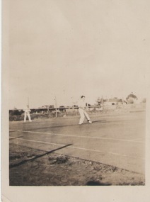
Photograph, C 1930s
The men were playing tennis on courts that were sited on railway land behind the post office between Evans Street and the railway line in Sunbury. The house in the background was in Evans Street near the post office.During the nineteenth century in Sunbury, various sporting groups such as tennis, cricket and football, were established in Sunbury.A non-digital sepia photograph with a white border of two men playing tennis. There is a house in the middle distance. The photograph is a Kodak print C592tennis, tennis courts, evans street -
 Port Fairy Historical Society Museum and Archives
Photograph, Pt Fairy Hospital looking east 1890, 1890
The land for this building was granted to the Benevolent Society by James Atkinson in 1850. Tenders were called for a new "Benevolent Asylum" in 1855, the foundation stone having been laid and by 1856 the first part of the Hospital was completedBlack and white photograph New addition to the hospital with i’ts bay windows. 5 women and two men posed to the sidehospital, health service, nurses, bay window -
 Melbourne Tram Museum
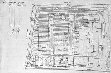
Document - Plan of Preston Workshops, The Met, c1990
Plan shows the layout of the Preston Workshops facility during The Met era, c1990. Shows tracks, buildings and overall land dimensions. Prepared prior to the duplication of the track over the railway line in Miller St. Yields information about Preston Workshops during The Met era.Photocopy - foolscap sheet of a Plan of Preston Workshops - The Met c1990tramways, preston workshops, drawings, plans -
 Surrey Hills Historical Society Collection
Photograph, Kleinert family gathered fro Christmas celebrations at 34 Union Road, Surrey Hills
William was a coach-builder, wheelwright and blacksmith. He moved from Prahran to Surrey Hills to property owned by the family. The house at 34 Union Road was built in 1905 for William and his wife Emily. Their son Ernest worked with him as a coach painter and also worked as a painter undertaking intricate hand painting on early cars. Their other son Martin played for the Surrey Hills Football Club. In return for the support given to the club by Mrs Emily Kleinert, the club built a rotunda in South Surrey Park as a memorial to her. Alan Holt research: Lot 6 was sold to Martin Kleinert by Karl Richter in 1860 together with a portion of another adjacent lot. From 1860-1885 Martin worked it as a market garden leasing some land for grazing when it was not required for gardening. He died in 1898. In a formal document, William declared he was the son of Martin "who purchased land in 1860, died in 1898 and the land has been continually occupied by father and family since. It has been cultivated as a market garden; when not being used for gardening it was let for cultivation and grazing." William died in 1939 and the property passed to his sons Martin and Ernest. The Kleinert land extended from Union Road to Essex Road. They ran horses, ducks and fowls and Emily Kleinert grew flowers. The Kleinert property later became the South Surrey Park. The family sold the land to the Camberwell Council in the 1950s. Ernest and Ida Kleinert lived on the corner of Scotsdale and Warrigal Roads. The donor of the photo Nada Harris, nee Kleinert, was Ernest and Ida's daughter. Ida lived to a good age (> 93 years) and in later life lived in Burwood.Black and white photo of a large group of men, women and children posed for the photograph which is taken outdoors. William Kleinert is identified as seated in the front centre playing his German melodion. Sons Ernest and Martin and William's daughters Ivy and Rose are also in the photo (not identified). Nada Kleinert (daughter of Ernest and Ida and 1st grand-daughter of William and Emily) is standing next to her great-grandmother Radford.surrey hills football club, blacksmiths, wheelwrights, coachbuilders, south surrey park, rotunda, miss ida kleinert, emily kleinert, mr william kleinert, miss ivy kleinert, miss rose kleinert, mr ernest kleinert, miss nada kleinert, mrs nada harris, mr martin kleinert -
 The Beechworth Burke Museum
Photograph - Lantern Slide, c1900
Miners from Snake Valley lobbied the Victorian Government in 1855 to make land available for sale for farming purposes as an alternative occupation and income for people who wished to stay in the region but move away from gold mining. A secondary motivation was to increase the supply of fresh produce and decrease prices of items that otherwise needed to be transported from Melbourne or other regions. Forty-three country lots were initially offered in the Three Mile area, ranging in size from two to ninety acres and costing from £1 to £3 per acre. An additional eighty-five country lots were auctioned later in the year, in addition to many smaller suburban lots. More lots were offered than sold, initially, but this represented conditions of sale requiring the total purchase cost up front which many people interested in purchasing could not afford, especially as land purchased for farming would accrue substantial additional costs for clearing and labour before becoming productive. Further lobbying activities and the election of parliamentary members sympathetic to the cause took place through the 1850s. Ovens Parliamentary Member, Daniel Cameron, was re-elected in 1856 on a platform of surveying the land for public selection with deferred payment options. Land reform remained an issue in the area through the 1850s and early 1860s, impacting broader decisions in the new State of Victoria relating to voting rights, use of Crown land and the farming of land that wasn't always suitable for the purpose. This photograph depicts Beechworth in approximately 1900, after several waves of land sales resulted in increasingly levels of development. Lantern slides, sometimes called 'magic lantern' slides, are glass plates on which an image has been secured for the purpose of projection. Glass slides were etched or hand-painted for this purpose from the Eighteenth Century but the process became more popular and accessible to the public with the development of photographic-emulsion slides used with a 'Magic Lantern' device in the mid-Nineteenth Century. Photographic lantern slides comprise a double-negative emulsion layer (forming a positive image) between thin glass plates that are bound together. A number of processes existed to form and bind the emulsion layer to the base plate, including the albumen, wet plate collodion, gelatine dry plate and woodburytype techniques. Lantern slides and magic lantern technologies are seen as foundational precursors to the development of modern photography and film-making techniques.This glass slide is significant because it provides insight into Beechworth's built environment and infrastructure in the early Twentieth Century, around the time of Australia's Federation. It is also an example of an early photographic and film-making technology in use in regional Victoria in the time period.Thin translucent sheet of glass with a square-edged image printed on the front and framed in a black backing. It is held together by metal strips to secure the edges of the slide.burke museum, beechworth, lantern slide, slide, glass slide, plate, burke museum collection, photograph, monochrome, indigo shire, north-east victoria, farming, squatters, miners, agriculture, land-clearing, land reform, daniel cameron, land sales, three mile, snake valley, tarrawingee -
 Ringwood and District Historical Society
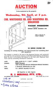
Flyer, Flyer advertising auction sale of ex service station site in Ringwood, Victoria - 1974
Single page advertisement for auction sale of restricted business site, corner of Whitehorse Road and Wantirna Road, Ringwood, Victoria, on Wednesday, 9th April (1974).Advertisement includes location map and terms of sale of 3 separate certificates of title on land zoned as Restricted Business (Not to be used for any petroleum product business). Sole Agents - K.J. Mulhall Pty. Ltd., 358 Lonsdale Street, Melbourne (Telephone) 67 8338, A.H. 91 1511. Auctioneer - Allan Lord. Handwritten notation describes this as originally the site of Ibbotson's Hay and Corn Store. -
 Ringwood and District Historical Society
Photograph, Newly Erected Ringwood East State School, Everard Road, 1925 (Two Photographs)
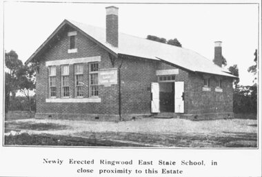
Printed below photograph, "Newly Erected Ringwood East State School, in close proximity to this Estate". Written on back of photograph, "Photo taken from Sub. Div. plan Land Sale 1st November 1924. Ringwood East Electric Station Estate, 1st November 1924. School Everard Road". Typed below another copy: "Ringwood East S.S. On completion 1925". -
 Coal Creek Community Park & Museum
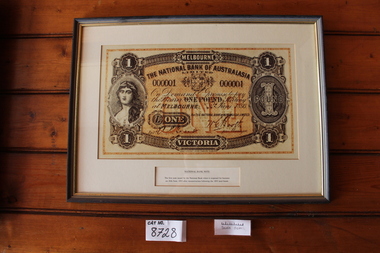
Nation Banknote Display
8728.1 - Thin wooden frame with very dark stain and gold paint on the inner part of the frame. 8728.2 - Very large print of a one pound note. 8728.3 - Brief description of the note and it's history.8728.2 - 1 - MELBOURNE - VICTORIA - ONE - POUND - THE NATIONAL BANK OF AUSTRALIA LIMITED - On demand I promise to pay the bearer ONE POUND sterling at MELBOURNE June 1893 - For THE NATIONAL BANK OF AUSTRALIA - Manager - ENTd 8728.3 - NATIONAL BANK NOTE - The first note issued by the National Bank when it reopened for business on 26th June, 1893 after reconstruction following the 1893 land boom. -
![Waterfall Scene Near the Buchan River / [by] Nicholas Caire, circa 1876](/media/collectors/550653872162f11fb04854aa/items/57825da5d0cdd1176ce3ed3d/item-media/57825e03d0cdd1176ce418cf/item-fit-380x285.jpg) Kew Historical Society Inc
Kew Historical Society IncPhotograph, Anglo-Australasian Photographic Company, Waterfall Scene Near the Buchan River, c. 1876
Nicholas Caire was born on Guernsey in the Channel Islands in 1837. He arrived in Adelaide with his parents in about 1860. In 1867, following photographic journeys in Gippsland, he opened a studio in Adelaide. From 1870 to 1876 he lived and worked in Talbot in Central Victoria. In 1876 he purchased T. F. Chuck's studios in the Royal Arcade Melbourne. In 1885, following the introduction of dry plate photography, he began a series of landscape series, which were commercially successful. As a photographer, he travelled extensively through Victoria, photographing places few of his contemporaries had previously seen. He died in 1918. Reference: Jack Cato, 'Caire, Nicholas John (1837–1918)', Australian Dictionary of Biography.An original, rare photograph from the series 'Views of Victoria: General Series' by the photographer, Nicholas Caire (1837-1918). The series of 60 photographs that comprise the series was issued c. 1876 and reinforced a neo-Romantic view of the Australian landscape to which a growing nationalist movement would respond. Nicholas Caire was active as a photographer in Australia from 1858 until his death in 1918. His vision of the Australian bush and pioneer life had a counterpart in the works of Henry Lawson and other nationalist poets, authors and painters.‘Waterfall scene near the Buchan River’ : Views of Victoria (General Series), No.39 : Albumen silver photograph | Photo on card with Title and Description on reverse | Mounted 24 x 30 cm; Photo 12 x 17 cm.On Reverse: ‘The Buchan River is a tributary of the great Snowy River, which extends itself from Port Ricardo, on the Gipps Land coast, to considerably beyond Mt. Kosciusko, in New South Wales. It is comparatively but a stream, but, like most of the smaller rivers in Victoria, it contains some beautiful scenery, peculiar to itself. Our present illustration is characteristic of its scenery, and is taken from a creek close to the River.’nicholas caire (1837-1918), buchan river, landscape photography - victoria -
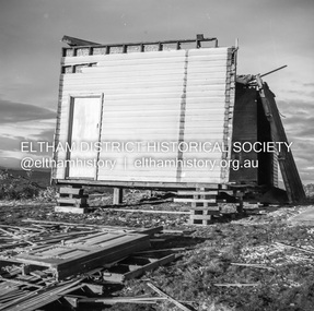
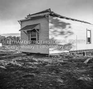
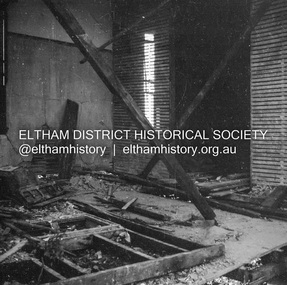
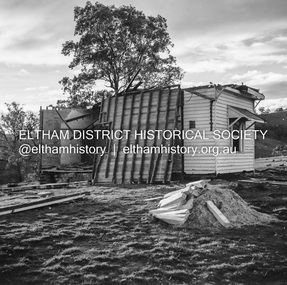
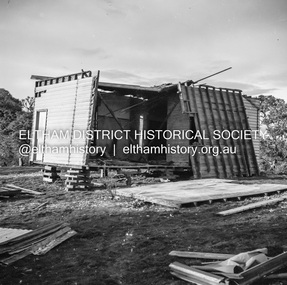 Eltham District Historical Society Inc
Negative - Photograph, J.A. McDonald, Inspection of storm damaged Abraham house at Kangaroo Ground, c. May 1962
Showing the effect of a wind storm that destroyed the house circa May 1962.. The Abraham family owned land near the Aqueduct and east of Nicholas Lane at Kangaroo Ground (based on photos, at or near 40 Nicholas Lane).Record of various Shire of Eltham infrastructure works undertaken during the period of 1952-1962 involving bridge and road reconstruction projects, sometimes with Eltham Shire Council Project Reference numbers quoted. It was during this period that a number of significant improvements were made to roads and new bridges constructed within the shire that remain in place as of present day (2022). In many situations, the photos provide a tangible visible record of infrastructure that existed throughout the early days of the Shire. The album was put together by or under the direction of the Shire Engineer, J.A. McDonald.1962-05, abraham house, kangaroo ground, nicholas lane, property damage, storm damage -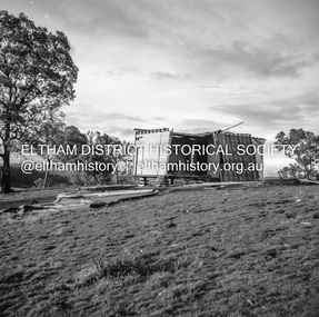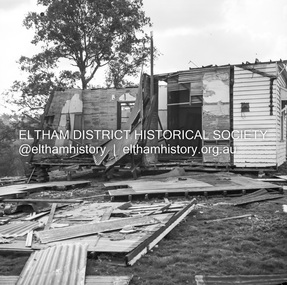
 Eltham District Historical Society Inc
Negative - Photograph, J.A. McDonald, Inspection of storm damaged Abraham house at Kangaroo Ground, c. May 1962
Showing the effect of a wind storm that destroyed the house circa May 1962.. The Abraham family owned land near the Aqueduct and east of Nicholas Lane at Kangaroo Ground (based on photos, at or near 40 Nicholas Lane).Record of various Shire of Eltham infrastructure works undertaken during the period of 1952-1962 involving bridge and road reconstruction projects, sometimes with Eltham Shire Council Project Reference numbers quoted. It was during this period that a number of significant improvements were made to roads and new bridges constructed within the shire that remain in place as of present day (2022). In many situations, the photos provide a tangible visible record of infrastructure that existed throughout the early days of the Shire. The album was put together by or under the direction of the Shire Engineer, J.A. McDonald.1962-05, abraham house, kangaroo ground, nicholas lane, property damage, storm damage, building surveyor, george e. newton -
 Eltham District Historical Society Inc
Negative - Photograph, J.A. McDonald, Inspection of storm damaged Abraham house at Kangaroo Ground, c. May 1962
Showing the effect of a wind storm that destroyed the house circa May 1962.. The Abraham family owned land near the Aqueduct and east of Nicholas Lane at Kangaroo Ground (based on photos, at or near 40 Nicholas Lane).Record of various Shire of Eltham infrastructure works undertaken during the period of 1952-1962 involving bridge and road reconstruction projects, sometimes with Eltham Shire Council Project Reference numbers quoted. It was during this period that a number of significant improvements were made to roads and new bridges constructed within the shire that remain in place as of present day (2022). In many situations, the photos provide a tangible visible record of infrastructure that existed throughout the early days of the Shire. The album was put together by or under the direction of the Shire Engineer, J.A. McDonald.1962-05, abraham house, kangaroo ground, nicholas lane, property damage, storm damage -
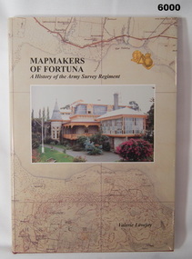 Bendigo Military Museum
Book - Mapmakers of Fortuna, a History of the Army Survey Regiment, Ex Fortuna Survey Association Inc, 2003
Covers the arrival of the Land Headquarters Cartographic Company at Fortuna Villa in 1942 until the disbandment of the Army Survey Regiment in 1996. Written by Valerie Lovejoy as part of her Masters degree at La Trobe University, BendigoUnit History of the Army Survey Regiment by Valerie Lovejoy, ISBN: 0-646-42120-4, 234 pages, 9 Chapters, 6 Appendices, Black and White photographs, Colored map extracts, Colored cover jacket, hard cover, nominal roll of Unit members.On first page, "Donated to Bendigo RSL Museum by Ex Fortuna Survey Association Inc 21 April 2022"royal australian survey corps, rasvy, army survey regiment, army svy regt, asr -
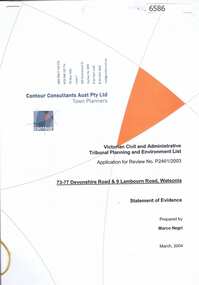 Greensborough Historical Society
Document, Statement of evidence: VCAT Application P2461/2003, prep. by Marco Negri, Contour Consultants Aust Pty Ltd, 2004_03
Lawyers for the City of Banyule commissioned a report on the town planning implications of a proposal to construct a multi-level building on land at the corner of Lambourn and Devonshire Roads Watsonia, relating to the Council's refusal of a permit and the subsequent hearing by VCAT22 p., black & white with col. plans.watsonia, lambourn road watsonia, devonshire road watsonia