Showing 10391 items
matching plan
-
 Bendigo Historical Society Inc.
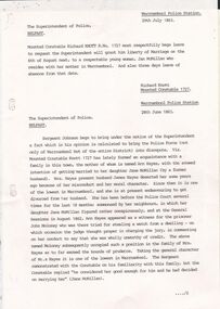
Document - CONSTABLE RYAN COLLECTION: NOTES FROM POLICE HISTORICAL UNIT
Three type written notes from the police Historical unit referring to Police station in Warrnambool, 1863.. Also attached plan of the Kangaroo Flat police Station.document -
 Bendigo Historical Society Inc.
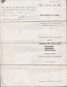
Document - MCCOLL, RANKIN AND STANISTREET COLLECTION: INDENTURE NO. 10852 BENDIGO, 1937
Document: Monument Hill Consolidated (Bendigo) N.L. 10852 lease of site of site for machinery 27/4/1937. Plan included. Signature Asst. Registrar of Titles.MCCOLL RANKIN & STANISTREETorganization, business, gold mining lease, mccoll rankin & stanistreet -
 Bendigo Historical Society Inc.
Photograph - FORTUNA COLLECTION: FORTUNA VILLA, circa 1970
Photograph: Fortuna Villa and a newspaper clipping from 'The Sun' April 8th 1970 referring to the Army Survey Regiment's plan to move out of the building. On a cardboard backingphotograph, landscape, bendigo, fortuna villa, survey regiment, the sun april 8th 1970 -
Bendigo Historical Society Inc.
Map - BENDIGO SHEET 12, Reproduced 1961
Map; Bendigo Sheet 12, Parish of Sandhurst , County of Bendigo, Parish plan, Scale 2 chains to 1 inch ( number 142 in Map Cupboard 1)map, bendigo, city streets, bendigo sheet 12, parish of sandhurst , county of bendigo -
Bendigo Historical Society Inc.
Map - BENDIGO SHEET 2, No date visible
Map: Parish plan showing portion of Bendigo city, West from the Echuca rail line, showing lake weeroona ( number 136 in Map Cupboard 1)map, bendigo, city streets, bendigo sheet 2, bendigo streets -
Bendigo Historical Society Inc.
Map - BAMAWM ESTATE, 12/.08/1912
Map: Bamawm Estate, Acquired under Closer settlements Acts 1904, County of Bendigo. Parish Plan Canvas backed. ( number 130 in Map Cupboard 1)map, bendigo, rural, bamawm estate, closer settlement acts 1904, county of bendigo -
Bendigo Historical Society Inc.
Map - BAMAWM ESTATE, 24/02/1931
Map: Bamawm Estate, Aquired under closer settlement Act 1904, County of Bendigo. Parish plan Canvas backed ( number 129 in Map Cupboard 1)map, bendigo, rural, bamawm estate, closer settlement acts 1904, county of bendigo -
Bendigo Historical Society Inc.
Map - PLAN OF BENDIGO CREEK, 12th March 1873
Map:Hand drafted plan of the Bendigo Creek, covering from Scott St. White Hills to Alder St. Kangaroo Flat. Scale 2 chains to 1 inchGeorge R------- ? City Surveyormap, bendigo, bendigo creek -
Bendigo Historical Society Inc.
Map - SANDHURST (PART), Circa 1880's
Map: Parish plan covering the area from Belle Vue Rd. to Barnard St. and Maple St to Short St. ( number 230 in Map Cupboard 1)map, bendigo, parish plan, sandhurst, belle vue road, barnard street, maple street , short street -
Bendigo Historical Society Inc.
Map - BENDIGO (SANDHURST) PART, No date visible
Map: Parish plan showing an area North West from the McKenzie St. View St. corner to Long Gully ( number 220 in Map Cupboard 1)map, bendigo, parish plan, bendigo, long gully -
Lakes Entrance Regional Historical Society (operating as Lakes Entrance History Centre & Museum)
Book, Victoria's Cemeteries and Crematoria - Options for Legislative Change - A Discussion Paper, 1998
Architectural drawings by Victorian Public Works Department. Lists plans of many public Buildings in Gippsland, and illustrates examples of schools, courthouses and Latrobe Bridge. Contains bibliography.architecture -
Whitehorse Historical Society Inc.
Legal record - Land Title, Certificate of Title, 1919
Lots 21 and 22 on Plan of Subdivision no. 6149 Crown Portion 89, Parish of Nunawading vol. 4192 fol. 838287, owned by State Savings Bank of VictoriaLots 21 and 22 on Plan of Subdivision no. 6149 Crown Portion 89, Parish of Nunawading vol. 4192 fol. 838287, owned by State Savings Bank of VictoriaLots 21 and 22 on Plan of Subdivision no. 6149 Crown Portion 89, Parish of Nunawading vol. 4192 fol. 838287, owned by State Savings Bank of Victoriablackburn road blackburn, walsham road blackburn, state savings bank of victoria -
Whitehorse Historical Society Inc.
Article, Council gets two new faces, 1992
Two new group mangers have been appointed to Nunawading Council - Ms Carol Matthew, Community Services (photo) and Mr Ray Glickman, Planning and DevelopmentTwo new group mangers have been appointed to Nunawading Council - Ms Carol Matthew, Community Services (photo) and Mr Ray Glickman, Planning and DevelopmentTwo new group mangers have been appointed to Nunawading Council - Ms Carol Matthew, Community Services (photo) and Mr Ray Glickman, Planning and Developmentmathew, carol, glickman, ray, city of nunawading -
 Whitehorse Historical Society Inc.
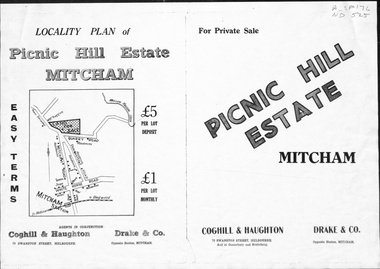
Pamphlet, Picnic Hill Estate, Mitcham, n.d
Photocopy of pamphlet, locality map and plan of 40 home sites on Picnic Hill estate extending from Quarry Road, Mitcham Road and McKeon Road, Mitchamland subdivision, mitcham road, mitcham, quarry road, mckeon road, wooddale grove, rotherwood avenue, cobham road -
Whitehorse Historical Society Inc.
Document, 8 Hazelmere Avenue Mitcham, c1953
Plan and elevation for proposed brick veneer residencePlan and elevation for proposed brick veneer residence, 8 Hazelmere Avenue, Mitcham for O.M.T. Grant Esq. J. Chugg, 2 Morey Street, Burwood, Builder.Plan and elevation for proposed brick veneer residencegrant, max, hazelmere avenue, mitcham, no 8, j.r.., chugg -
Whitehorse Historical Society Inc.
Map, Nunawading Planning Scheme, 7/06/1994 12:00:00 AM
Local Section maps 1 - 4 with index. Geographical information system land Information Branch. Scale 1:10,000 Shows zoning under planning scheme.Local Section maps 1 - 4 with index. Geographical information system land Information Branch. Scale 1:10,000 Shows zoning under planning scheme.Local Section maps 1 - 4 with index. Geographical information system land Information Branch. Scale 1:10,000 Shows zoning under planning scheme.blackburn, blackburn north, blackburn south, forest hill, heatherdale, maps, nunawading, vermont, vermont south, town planning, burwood east, laburnum -
Whitehorse Historical Society Inc.
Article, Eastern Freeway, 8/07/1992 12:00:00 AM
'Council affirms freeway support' describing Box Hill Council support for cancellation of freeway plans and Nunawading's support for the Freeway.'Council affirms freeway support' describing Box Hill Council support for cancellation of freeway plans and Nunawading's support for the Freeway. Nunawading Post, 8 July 1992.'Council affirms freeway support' describing Box Hill Council support for cancellation of freeway plans and Nunawading's support for the Freeway. eastern freeway, city of box hill, freeways, city of nunawading -
Whitehorse Historical Society Inc.
Article, Sell-off bombshell, 2010
Article on the decision of Reading Entertainment International to abandon its plan to redevelop the former Nubrik brickworks site in Middleborough Road Burwood East and to sell the 20ha site.Article on the decision of Reading Entertainment International to abandon its plan to redevelop the former Nubrik brickworks site in Middleborough Road Burwood East and to sell the 20ha site.Article on the decision of Reading Entertainment International to abandon its plan to redevelop the former Nubrik brickworks site in Middleborough Road Burwood East and to sell the 20ha site.middleborough road, burwood east, reading entertainment australia pty ltd -
Whitehorse Historical Society Inc.
Map, Alterations to residence, 1/02/1979 12:00:00 AM
Plans of proposed alterations and additions to residence for Mr. R. Doreian.Plans of proposed alterations and additions to residence for Mr. R. Doreian at 567 Whitehorse Road, Mitcham Scale 1:100,500|2 copies, 1 stamped APPROVEDPlans of proposed alterations and additions to residence for Mr. R. Doreian.dorien, bob, whitehorse road, mitcham no.567 -
Whitehorse Historical Society Inc.
Document, Set to tackle top job, 2008
Elgar Ward Councillor and Greens member Helen Harris, who was elected as Mayor of Whitehorse, is set to tackle planning issues, climate change and their effects of financial meltdown.Elgar Ward Councillor and Greens member Helen Harris, who was elected as Mayor of Whitehorse, is set to tackle planning issues, climate change and their effects of financial meltdown.Elgar Ward Councillor and Greens member Helen Harris, who was elected as Mayor of Whitehorse, is set to tackle planning issues, climate change and their effects of financial meltdown.harris, helen, city of whitehorse -
 Whitehorse Historical Society Inc.
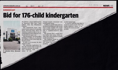
Article, Bid For 176-Child Kindergarten, 2017
Plans for a 176-child Kindergarten in East Burwood have been lodged with the Whitehorse Council. By the Greenwood Early Education Centre for 6 Lakeside Drive, Burwood East.Plans for a 176-child Kindergarten in East Burwood have been lodged with the Whitehorse Council by the Greenwood Early Education Centre for 6 Lakeside Drive, Burwood East.Plans for a 176-child Kindergarten in East Burwood have been lodged with the Whitehorse Council. By the Greenwood Early Education Centre for 6 Lakeside Drive, Burwood East.burwood east, kindergarten, kindergartens, lakeside drive, burwood east, city of whitehorse, tally ho business park, east, burwood -
Whitehorse Historical Society Inc.
Article, Brickworks Set in Stone, 2016
A draft plan for the 20 ha site of the former brickworks in Burwood East .A draft plan for the 20 ha site of the former brickworks in Burwood East has been approved to include 950 homes, a kindergarten, an urban plaza and shopping centre.A draft plan for the 20 ha site of the former brickworks in Burwood East . brickworks, burwood east, burwood heights -
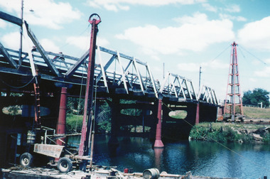 Lakes Entrance Regional Historical Society (operating as Lakes Entrance History Centre & Museum)
Photograph, Scarce, Keith, 1955
Colour photograph of the W L Sides and Son drilling rig beside the bridge over the Mitchell River, testing for foundations for the planned new bridge. Bairnsdale Victoriabridges, waterways, associations -
 Bendigo Historical Society Inc.
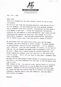
Document - MERLE HALL COLLECTION: LETTER TO JOHN LITTLE 2001
Letter to John Little dated Oct 1st 2001 (from Merle Hall - but probably signed only) re disbanding of AB and plans for final AGM (and 'Wake') -
 Kew Historical Society Inc
Photograph - W.B. Villa, Kew, c.1919
The photograph offers significant information relating to late Victorian / Federation colour schemes and fencing.The block fronted villa has a corrugated iron roof and a flat projecting verandah, ornamented with a trellis design of timber. The front window features a timber shade, mounted on brackets. The treatment of the block-fronted panels shows that there is an attempt to highlight imitation quoining through use of a darker colour. The windows and door are also in this darker shade. The front fence and gate are made of wooden pickets. It is unlikely that the photograph was taken at the time of the villa's construction given the size of the shrub/tree in the front garden.Subdivision plans are historically important documents used as evidence of the growth of suburbs in Australia. They frequently provide information about when the land was sold on which a built structure was subsequently constructed as well as evidence relating to surveyors and real estate and financial agents. The numerous subdivision plans in the Kew Historical Society's collection represent working documents, ranging from the initial sketches made in planning a subdivision to printed plans on which auctioneers or agents listed the prices for which individual lots were sold. In a number of cases, the reverse of a subdivision plan in the collection includes a photograph of a house that was also for sale by the agent. These photographs provide significant heritage information relating house design and decoration, fencing and household gardens.A real estate photograph, mounted on brown card, showing a double fronted weatherboard villa, located in Kew, Victoria. On the reverse of the photograph is a subdivision plan for the Altyre Estate.Stamped on mount: Top - "KEW. Close tram. Fine View. / W.B. Villa Containing 8 Rooms. / Up-to-date Conveniences. EL Etc." Below - "Land 40 x 165. 615 pounds. Sold"houses - kew, real estate photographs -
Kew Historical Society Inc
Archive (Sub-series) - Subject File, Boroondara General (Kew) Cemetery - Significance, 1958
Various partiesReference, Research, InformationKHS OrderReference file containing a photocopy of ‘The Historical Significance of the Boroondara General Cemetery, Kew - 1858-1900 (O’Neill, Frances, Monash University, 1985, 64pp with maps and plans)boroondara general (kew) cemetery, significance assessmentsboroondara general (kew) cemetery, significance assessments -
 Kew Historical Society Inc
Book, SF Clarke Publishing Co, The Story of Australia: Past and Present In Pen and Picture (Vol. 3), 1925
Sydney : S.J. Clarke Publishing, [1924 or 1925] [22] p., [38] p. of plates : ill., facsims., maps plans, ports. ; 27 cm. Volume 3non-fictionaustralia -- history -
Canterbury History Group
Ephemera - One for a Canterbury Connoisseur, 1998
Real Estate advertisement for auction of 1/12 Balwyn Road Canterbury on the 14th February 1998. Includes black and white sketch of residence and a floor and site plan.canterbury, sinclair and co, balwyn road -
Canterbury History Group
Ephemera - Timeless Elegance, enchanting piece of history, 1999
Real estate advertisement for auction on 27th November 1999 of 170 Mont Albert Road Canterbury (c1890s), includes coloured photographs of exterior and interior and floor plans.canterbury, mont albert road, victorian style, noel jones -
Canterbury History Group
Ephemera - 17 Mont Albert Road Canterbury, [1996]
Real estate advertisement for the sale by auction of "Falkirk" 17 Mont Albert Road Canterbury on Saturday 30 November [1996] Includs a sketch of the house and a floor plan.canterbury, mont albert road, falkirk