Showing 23748 items
matching sardine-creek
-
 Bendigo Historical Society Inc.
Map - TOOLLEEN : COUNTY OF BENDIGO, 25-5-26
Map. Toolleen, County of Bendigo, County of Rodney, Campaspe, Colbinabbin, Cornella, Crosbie, Muskerry, Mount Pleasant Creek, Township of Toolleen. By authority H.J. Green, Govt. Printer. Photo-Lithographed at the Department of Lands and Survey, Melbourne by W.J. Butson, 25-5-26. (number 106 in map cupboard 1)H.J. Green, Govt. Printermap, bendigo, toolleen -
Bendigo Historical Society Inc.
Map - TOOLLEEN : COUNTY OF BENDIGO, 25-5-26
Map. Toolleen, County of Bendigo, County of Rodney, Campaspe, Colbinabbin, Cornella, Crosbie, Muskerry, Mount Pleasant Creek, Township of Toolleen. By authority H.J. Green, Govt. Printer. Photo-Lithographed at the Department of Lands and Survey, Melbourne by W.J. Butson, 25-5-26. (number 105 in map cupboard 1)H.J. Green, Govt. Printer.map, bendigo, toolleen -
 Hume City Civic Collection
Photograph
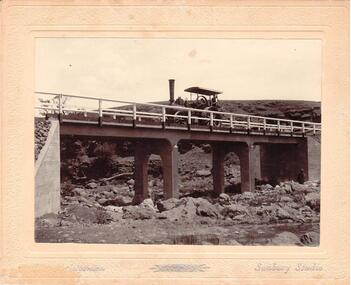
Chris. Christiansen had a barber shop in Sunbury and was the photographer in the town from 1895 until 1916. He conducted his business in a building situated on the corner of Evans and Brooks Streets. The Gillies Bridge is situated on the Wildwood Road, just off the Lancefield Road.A mounted sepia photograph of the Gillies Bridge at Sunbury. The mounting is cream with silver writing across the bottom of the photograph. There is a man driving a steam roller (traction engine) across the bridge and another man is standing at the bottom of the bridge on the RHS. The creek and rocks are in the foreground. Cream mounting - 2 cm wide with silver inscriptionsChristiansen / Sunbury Studiosgillies bridge, wildwood road, sunbury, bridges, steam rollers, bulldozers, tractors, christiansen, chris, photographers, george evans collection -
Lakes Entrance Regional Historical Society (operating as Lakes Entrance History Centre & Museum)
Book, Gippsland Heritage Journal No 9, 1990
Issue 9 of a series contains short articles on George Secar Ivor Dennis C J Goodman Edward Thomson Andrew Hutton J H Vog Louisa Campbell- Coulson Archbishop Mannix. Also Gippsland hospital 1866-1900 the Gippsland Road 1836- 1848 the Freestone Creek petitisocial history -
 Clunes Museum
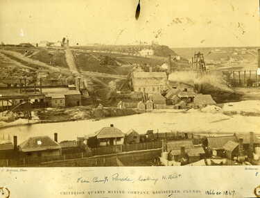
Photograph - PHOTOGRAPH CRITERION QUARTZ MINING COMPANY, C. NETTLETON PHOTO MELBOURNE, 1866 / 1867
.1 SEPIA PHOTOGRAPH FROM CAMP PARADE LOOKING N EAST CRITERION QUARTZ MINING COMPANY REGISTERED CLUNES 1866 OR 1867 MINE IN BACKGROUND, HOUSES ON EDGE OF CREEK PORT PHILLIP HOTEL 1859 - 1890. PORT PHILLIP 1ST BATTERY. .2 SEPIA PHOTOGRAPH OF CRITERION MINING COMPANYCRITERION QUARTZ MINING COMPANYphotography, port phillip hotel, criterion quartz mining company -
 Lakes Entrance Regional Historical Society (operating as Lakes Entrance History Centre & Museum)
Photograph, Fish Marie, 1977
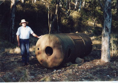
Date made 18 January 1977.Colour photograph of Rex Fish standing beside the boiler which provided steam power to drive the winch to transfer rock from the tram, trucks to the barge at North Arm. This rock quarried at Mississippi Creek was used to stabilise the entrance piers, and build rock groynes around the lakes. Lakes Entrance Victoriavegetation, waterways, historic sites -
 Southern Sherbrooke Historical Society Inc.
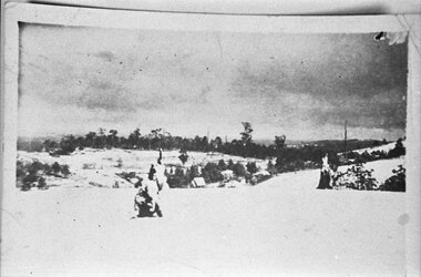
Photograph - A little bit of “Aura” snow
Photograph taken from the hill to the north of Menzies Creek. There has been a heavy snowfall and dark clouds are in the sky. In the centre of the photo St Cuthberts Church is visible in the distance, with houses beyond it. Buildings are also visible in the vicinity of the railway station. An indistinct object in the foreground of the photo may be two children playing. -
 Bendigo Historical Society Inc.
Slide - DIGGERS & MINING. THE DIGGING - THE DIGGERS, c1800s
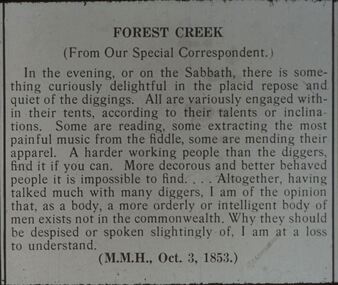
Diggers & Mining. The Digging - The Diggers. Slide: FOREST CREEK (From Our Special Correspondent.) Article speaks of the diggers enjoying the Sabbath eve by playing music, reading, and mending clothes. The writer believes the diggers to be hard working and intelligent people. Markings: 65 994.LIF:6. Used as a teaching aid.hanimounteducation, tertiary, goldfields -
 Bendigo Historical Society Inc.
Photograph - PETER ELLIS COLLECTION: NUNNERY AT KOROIT
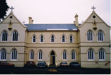
Colour photograph. Large cream building. Crosses on peaks. Cars parked in front of building. Back of photo reads: Nunnery at Koroit. Emu Creek was billeted there for Port Fairy F.F. early 1990's. Peter snored so loudly that two members swapped rooms and one went to sleep in the bus!buildings, church, nunnery at koriot -
 Bendigo Historical Society Inc.
Photograph - PETER ELLIS COLLECTION: EMU CREEK BUSH BAND, 3rd May, 1992
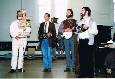
Colour photograph. 4 men standing. Emu Creek. Concertina. Banjo. Piano. Back of photo reads: 1992/7 over 21. 3.5.1992. Launch of Harry McQueen's tape St Mary's Hall, Castlemaine. John Williams, Gary Lovejoy, Ian Walder, Peter Ellis. Negative Don Walker.entertainment, music, bush band -
 Melbourne Tram Museum
Negative, Wal Jack collection, 1940's
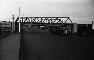
Black and white negative by Wal Jack of W4 670 (Maribyrnong River, route 54), passing under the rail over bridge for the Coburg railway line in Racecourse Road, Flemington. Tram about to cross the Moonee Ponds Creek bridge. Tram number identified on print in album. Photo undated, c1940.trams, tramways, racecourse road, w4 class, route 54, tram 670 -
 Bendigo Historical Society Inc.
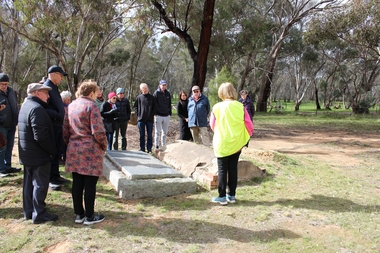
Bendigo Historical Society Walking Tour of Axedale, 1st Sept 2024
Axedale is a town in Victoria, Australia. It is located on the McIvor Highway, in the City of Greater Bendigo, east of Bendigo. It was surveyed and proclaimed in 1861. At the 2021 census, Axedale had a population of 984. The town is nestled alongside the Campaspe River which feeds out of Lake Eppalock. It has a golf course, tennis courts, a school, a pub and a convenience store/petrol station. It lies between Heathcote and Bendigo.Forty Photos taken on the walking tour of Axedale by the Bendigo Historical society. Places visited included the Protestant and Catholic Cemeteries, the "Blue Stone House", the 150-year-old bridge over the Axe Creek on the Sugerloaf Road, the old Cobb and Co Stables, St Andrews Church and the Campaspe River Bridge.axedale, bendigo historical society walking tour, st andrews church axedale, axedale cemetery, axe creek bridge, campaspe, cobb and co stables axedale, blue stone house axedale -
 Bendigo Historical Society Inc.
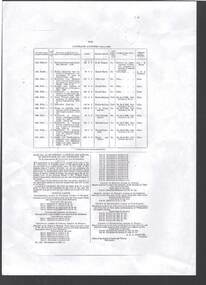
Document - BOARD OF WORKS, MELBOURNE: CONTRACTS ACCEPTED & LAND SALES FOR 1860
Page 2223 titled Contracts Accepted - (Series 1860). Contracts accepted are for Raising and removing sunken ship Marilla; Removal of Toll-gate from Mount Alexander Road and re-erection of same at Middle Gully; Erection of toll-house on Melbourne/Ballarat Road near Ballan; Erection of toll-house on Bendigo Road at Kangaroo Flat; Castlemaine to Ballarat - Erection of toll-house at Campbell's Creek; Construction of 2870 chains of Lower Western Road, west of Camperdown; Erection of two bridges and other improvements on the Clunes to Amherst Road; Erection of timber bridge, & c., over Two-mile Creek - Beechworth to Bowman Forest; Formation of roadway at head of Buckland Gap - Beechworth to Bowman Forest; Construction of culvert, & c., Rowe's Creek - Beechworth to Bowman Forest; Ararat and South-western sea-board road - erection of bridge over Dennicull Creek and other improvements. Land Sales - 4 Lots - Elsternwick, parish of Prahran, County of Bourke; 2 Lots - Dandenong, County of Bourke; 20 Lots - Lillydale, Parish of Yering, County of Evelyn, 1 suburban Lot - County of Evelyn, Parish of Yering; 1 Allotment - Romsey, County of Bourke, Parish of Lancefield; 5 Lots - County of Mornington, Parish of Langwarrin, and 2 Lots - County of Mornington, Parish of Fingal. Lots to be sold at the Auction Rooms of Mr. William Perry, Great Collins Street, Melbourne. A F A Greaves, President, Office of the Board of Land and Works, Melbourne.bridge, construction, timber bridges, board of works, melbourne - contracts accepted & land sales, 'marilla', f m pingree, jno r bailey, robert heron, john gray, donald ross, hector mclean, c j glynn and co, john nicholls and co, michael cleary, thomas cairncross, brown and gibson, queen victoria, mr william perry, mr de castella, willoughby, barker, a f a greeves, board of land and works melbourne -
 Falls Creek Historical Society
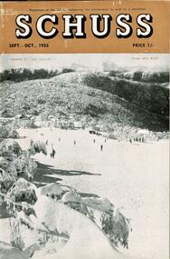
Journal - Schuss Vol. 21. No. 7 September - October 1955
Schuss was advertised as Victoria’s Official Ski Journal It was issued monthly from 1935 to 1961 except during the war when summer issues covered two months. This continued after the war, but it averaged 10 issues annually over its 25 year life. Schuss was published by the Ski Club of Victoria which had a membership of 38 Ski Clubs and demanded to be recognised as the prime authority on skiing in the state. The other 30 ski clubs with 85% of the members disagreed and the politics of skiing became heated. These clubs formed the Federation of Victorian Ski Clubs with their own journal, Ski Horizon. With the establishment of the Victorian Ski Association, Ski-Horizon published its last issue in Nov - Dec. 1955 and the role of the official journal was fully taken over by “Schuss”. This item is significant because it contains stories, images and information documenting the development of the ski industry in Victoria.The journal features stories and events chronicling developments in Victoria and internationally. Page 234 - 235 featured an extensive report on developments at Falls Creek, Victoria. FALLS CREEK SKI CENTRE CONTINUES ITS STEADY ADVANCE Falls Creek skiing has continued to show markedly improved standards over this past season. Better facilities in and around the ski village itself have been accompanied by better skiing on the abundant snow covering all adjacent slopes. Just to mention a few of those facilities in the village: There have been extensions and big improvements at the Hymans Ski School, a number of excellent new club lodges have come into being, Nissen Lodge is in operation at the foot of the tow and adjacent slopes all setting new standards of ski-living that must make other resorts watch their step. While the advent of Cecil Dobson's General Store and Ski Centre, added to the service already available at the Nissen tow house, has removed all the old problems of food supply. Nissen ski-tow, the enticing face of the Frying Pan has given good service for a number of seasons now. To it has been added this year Bob Hyman's small portable tow which has worked for most of the season on the slope just in front of Skyline Lodge. The racing programme carried out at Falls Creek through this season has maintained the high standard shown in all other affairs. The main events started with the N.E.D.S.A. Championships early in August, then followed the Victorian and S.C.V. Nordic titles, and the Intermediate events.schuss journal, the ski club of victoria, developments in falls creek -
 Eltham District Historical Society Inc
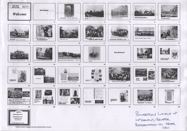
Document - Folder, Ross McDonald et al, McDonald, 2011
Based on the book From Laggan to Arthur's Creek : the McDonald family history and connections with the Draper family, Charnwood / written and presented by Ross McDonald.26 A4 pages of powerpoint slides and speaking notes Powerpoint filemcdonald family, draper family, charnwood, arthur's creek, charles draper, bruce draper, ross mcdonald -
 Eltham District Historical Society Inc
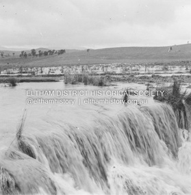
Album - Photograph, J.A. McDonald, Eltham-Yarra Glen Road, 19 Oct. 1956
Dixons Creek Road 19th October, 1956 Scour developing back onto road from Smedley’s property near Blease RoadRecord of various Shire of Eltham infrastructure works undertaken during the period of 1952-1962 involving bridge and road reconstruction projects, sometimes with Eltham Shire Council Project Reference numbers quoted. It was during this period that a number of significant improvements were made to roads and new bridges constructed within the shire that remain in place as of present day (2022). In many situations, the photos provide a tangible visible record of infrastructure that existed throughout the early days of the Shire. The album was put together by or under the direction of the Shire Engineer, J.A. McDonald.infrastructure, road construction, shire of eltham, bridge construction, eltham-yarra glen road, 1956-10-19, dixons creek bridge, dixon's creek road, floods -
 Eltham District Historical Society Inc
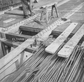
Album - Photograph, J.A. McDonald, General; Albion Street and Eltham-Yarra Glen Road, Oct. 1955
General – Country Roads Board Albion Street bridge over Moonee Ponds Creek, Brunswick West Deck Forms October 1955Record of various Shire of Eltham infrastructure works undertaken during the period of 1952-1962 involving bridge and road reconstruction projects, sometimes with Eltham Shire Council Project Reference numbers quoted. It was during this period that a number of significant improvements were made to roads and new bridges constructed within the shire that remain in place as of present day (2022). In many situations, the photos provide a tangible visible record of infrastructure that existed throughout the early days of the Shire. The album was put together by or under the direction of the Shire Engineer, J.A. McDonald.infrastructure, road construction, shire of eltham, 1955-10, albion street, bridge construction, country roads board, benchmark studies, brunswick west, moonee ponds creek -
 Eltham District Historical Society Inc
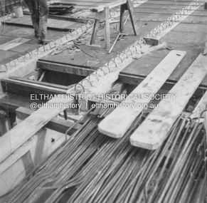
Album - Photograph, J.A. McDonald, General; Albion Street and Eltham-Yarra Glen Road, Oct. 1955
General – Country Roads Board Albion Street bridge over Moonee Ponds Creek, Brunswick West Deck Forms October 1955Record of various Shire of Eltham infrastructure works undertaken during the period of 1952-1962 involving bridge and road reconstruction projects, sometimes with Eltham Shire Council Project Reference numbers quoted. It was during this period that a number of significant improvements were made to roads and new bridges constructed within the shire that remain in place as of present day (2022). In many situations, the photos provide a tangible visible record of infrastructure that existed throughout the early days of the Shire. The album was put together by or under the direction of the Shire Engineer, J.A. McDonald.infrastructure, road construction, shire of eltham, 1955-10, albion street, bridge construction, country roads board, benchmark studies, brunswick west, moonee ponds creek -
 Eltham District Historical Society Inc
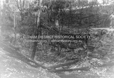
Album - Photograph, J.A. McDonald, Salters Rush Road, Smiths Gully, Aug. 1962
Salters Rush Road, Smiths Gully Bridge over Salters Rush Creek following bush fires 15-16 Jan. 1962Record of various Shire of Eltham infrastructure works undertaken during the period of 1952-1962 involving bridge and road reconstruction projects, sometimes with Eltham Shire Council Project Reference numbers quoted. It was during this period that a number of significant improvements were made to roads and new bridges constructed within the shire that remain in place as of present day (2022). In many situations, the photos provide a tangible visible record of infrastructure that existed throughout the early days of the Shire. The album was put together by or under the direction of the Shire Engineer, J.A. McDonald.H941 stamped on reverse (film processing #)infrastructure, shire of eltham, bridge construction, road construction, 1962-08, bushfires, salters rush road, smiths gully, victorian bushfires - 1962 -
 Eltham District Historical Society Inc
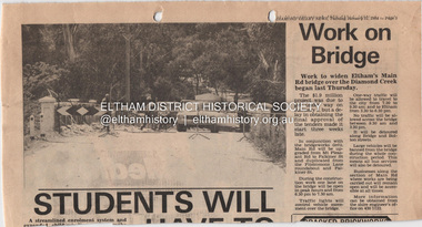
Document - Property Binder, Main Road Bridge, Eltham
Newspaper article: Diamond Valley News, 31 January 1984, work to begin on widening of Main Road Bridge over Diamond Creek.main road, bridges, main road bridge, diamond creek, eltham (vic) -
 Eltham District Historical Society Inc
Negative - Photograph, J.A. McDonald, Heidelberg-Kinglake Road, 3 Nov. 1959
Job 56M431 Contractors Wolf and Wood Yow Yow Creek Bridge Curve improvement north of bridge site 3 November 1959Record of various Shire of Eltham infrastructure works undertaken during the period of 1952-1962 involving bridge and road reconstruction projects, sometimes with Eltham Shire Council Project Reference numbers quoted. It was during this period that a number of significant improvements were made to roads and new bridges constructed within the shire that remain in place as of present day (2022). In many situations, the photos provide a tangible visible record of infrastructure that existed throughout the early days of the Shire. The album was put together by or under the direction of the Shire Engineer, J.A. McDonald.infrastructure, shire of eltham, bridge construction, heidelberg-kinglake road, road construction, yow yow creek, 1959-11-03 -
 Eltham District Historical Society Inc
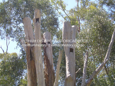
Photograph, Fay Bridge, Nesting hollows for birds in dead tree trunks, St Andrews, 29 January 2020
Artificial nesting hollows in tree trunks to encourage wildlife situated near St Andrews Market on the road to Kinglake just near the creekfay bridge collection, 2020-01-29, kinglake road, nesting hollow, st andrews -
 Phillip Island and District Historical Society Inc.
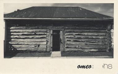
Photograph - Post Card, 1974
Postcard sent to Jean Archibald by Helen Jansson whilst holidaying at Mt Beauty, Omeo and Fall's Creek area. Donated by Helen Jansson.Black & White postcard of the Gaol in Omeo. Letter on back to Jean Archibald from Helen Jansson posted on the 18th April 1974."Omeo - Vic" by HSomeo gaol, mrs helen jansson, jean archibald -
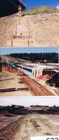 Greensborough Historical Society
Photographs, Gary Partington, Greensborough By-Pass, 1986_
The Greensborough by-pass extends from Grimshaw Street in the south to Diamond Creek Road in the north. It is intersected by the eastern end of the Metropolitan Ring Road.Unpublished photographs of the construction of the Greensborough by-pass.21 colour photographs of the construction phase of the Greensborough By-pass.greensborough bypass, roads, greensborough, gary partington, metropolitan ring road -
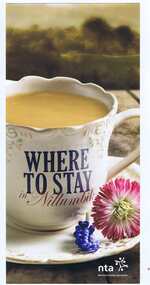 Greensborough Historical Society
Leaflet, Nillumbik Tourist Association, Where to stay in Nillumbik, 17/10/2015
Lists 10 major tourist accommodations in: Bundoora, Diamond Creek, Eltham, Hurstbridge, Kangaroo Ground, Panton Hill, Research, St AndrewsColour, printed both sides, map of area, A4 folded twicenillumbik -
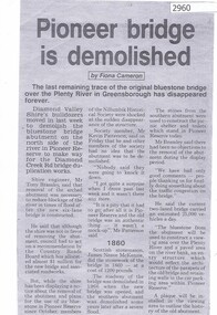 Greensborough Historical Society
Newspaper clipping, Fiona Cameron, Pioneer bridge is demolished, by Fiona Cameron, 1974_
Describes the removal of the bluestone bridge abutment on the north side of the Plenty River in Greensborough, to make way for the Diamond Creek Road bridge duplication.Photocopy of news articleplenty river, diamond creek road -
 Greensborough Historical Society
Article, Greensborough Historical Society et al, Jonathan Lionel Mills, 1914-1918
A short article about Jonathan Lionel Mills and his service in World War 1. He was born in Upper Diamond Creek (Plenty).One page, text and colour images.world war 1 project, jonathan lionel mills -
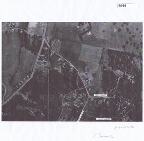 Greensborough Historical Society
Aerial Photograph, Greenhills Aerial View, 1945_
Section from the 1945 aerial survey of Greensborough, including part of Diamond Creek Road, Greenhill Road, Crest Street and Albion Crescent.Photocopy of part of 1945 aerial survey. Some streets have been marked.greenhills -
 Greensborough Historical Society
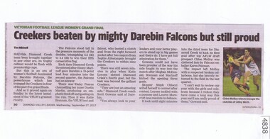
Newspaper Clipping, Diamond Valley Leader, Creekers beaten by mighty Darebin Falcons but still proud, 27/09/2017
Had this Diamond Creek team been brought together in any other era, its trophy cabinet would be flush with premiership cupsNews article 1 page, black text, colour image.vflw, diamond creek football club, darebin falcons football club, victorian football league women -
 Eltham District Historical Society Inc
Negative - Photograph, George W. Bell, Foot Bridge to Eltham High School, c.1960
Footbridge over the Diamond Creek at Dalton Street near Withers Way. It has since been replaced and integrated into the Wingrove Park Trail.This photo forms part of a collection of photographs gathered by the Shire of Eltham for their centenary project book,"Pioneers and Painters: 100 years of the Shire of Eltham" by Alan Marshall (1971). The collection of over 500 images is held in partnership between Eltham District Historical Society and Yarra Plenty Regional Library (Eltham Library) and is now formally known as the 'The Shire of Eltham Pioneers Photograph Collection.' It is significant in being the first community sourced collection representing the places and people of the Shire's first one hundred years.Digital image 4 x 5 inch B&W Negsepp, shire of eltham pioneers photograph collection, eltham, eltham high school, foot bridge, bridge, dalton street, diamond creek (creek), george w. bell collection, wingrove park trail, withers way