Showing 1401 items
matching bending
-
 Kew Historical Society Inc
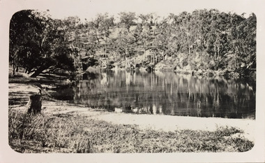
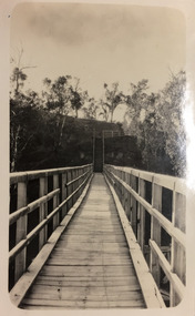
Photograph - Zig-Zag Bridge, 1924
Henry Beater Christian (1886-1962) , was a descendant of one of the earliest settler families in Kew. Employed at the Kew Asylum as a 'public servant', he was a skilled amateur photographer, photographing numerous scenes in Kew and on his travels around Victoria. The majority of his photographs date from 1916 to 1929. His finest photographs are housed in two photograph albums. Digital copy of a photograph from page 8 of the 47-page photograph album containing 261 gelatinous silver images, loaned by Diane Washfold with permission given to digitise and hold a copy in our collection. The Zig-Zag Bridge linked the grounds of the Yarra Bend and Kew Asylums. The wooden bridge was constructed in the 1870s and lasted through numerous floods until its destruction in 1929. A horizontal structure, the walkway was reached via a wooden staircase. The steps were requires due to the different levels of the banks on this stretch of the river. The photo is taken from the Kew side of the river. "Zig-Zag Bridge"henry beater christian (1886-1962), landscape photography, kew (vic.) — yarra river, christian-washfold collection, photograph albums, zig-zag bridge -
 Stawell Historical Society Inc
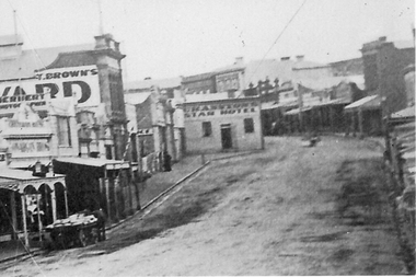
Photograph, Enlargement of Catalogue number 0541 of Main Street looking East featuring the Star Hotel, 1890's
Enlargement of right hand side of photo 0541. Top end of Main St. looking East towards Big Hill. From left Herbert Photographic, T Brown, Star Hotel on bend jutting out into middle of road. Mechanics Institute in background. Two Horse wagon in street on left.stawell businesses streetscape -
 Bendigo Historical Society Inc.
Newspaper - LONG GULLY HISTORY GROUP COLLECTION: EAGLEHAWK ROAD - LONG GULLY
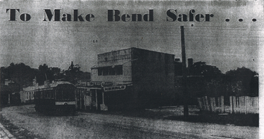
Copy of a newspaper photo titled To Make Bend Safer. Photo shows a tram passing a newsagent shop. On the right is a dilapidated picket fence. Allso hand written paper on one side is: Approx 1966 ? One of the last trams No 18 to run up Main Street of Long Gully (Bond Street) Now known as Eaglehawk Road. On Left - Post Office - now Gents Hairdresser & Rose of No 3 Australia Hotel. On Right - Les & Marie Norris Newsagency & Mixed Business. 2 story building was Commercial Hotel. No 26 Tram was the last to run between Bendigo, Long Gully & Eaglehawk. Still running as a Tourist. Donated by Alan Crossley. tram in Bendigo 1987 1985. On the other side is written: One building has already been demolished and the proprietor of the Newsagency & mixed business Mr. L W Norris, will also demolish and rebuild further back from the road in preparation for eventual re-alignment of the Long Gully bend by the Country Roads Board. The Board declared an alignment some years ago for the corner - a severe traffic hazard - but, the assistant Divisional Engineer, Mr G Marshallsea said yesterday the Board had no immediate plans. These were one of the last Trams to run through Long Gully.bendigo, history, long gully history group, the long gully history group - eaglehawk road - long gully -
 Eltham District Historical Society Inc
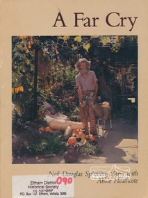
Book, Neil Douglas et al, A far cry / Neil Douglas spinning yarns with Abbie Heathcote, 1979
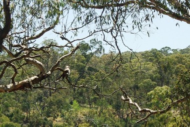
Reminiscences of environmental artist Neil Douglas as told to Abbie Heathcote. Kangaroo Island stories, living naturally, bumbling through the Depression, Robinson Crusoe gardening, trials of a conservationist, health and home, artist friends, aninal friends. Illustrated by Neil Douglas and incudes photographs of his home and garden at Bend of Islands.1. Paperback; 140 p. : ill. ; 25 cm. 2. Hardback (missing dust jacket); 140 p. : ill. ; 25 cm.ISBN 095950950xstories, social customs, alternative lifestyles, kangaroo ground, gardening, reminiscences, bend of islands, conservation, neil douglas, abbie heathcote, environment, -
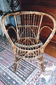 Churchill Island Heritage Farm
Furniture - Armchair, child's, c. 1940s
This particular type of chair was also known as a Bentwood Twig Wicker Child’s chair. This process was founded by German Thomas Thonet in 1855, and involved wetting or steaming wood, then bending it and letting it harden into curved shapes and patterns. This provided a cheaper and more practical version of furniture than earlier – and heavier – hand-carved furniture.Child's armchair, slatted base and back. Bentwood with wide, circular armrests and mottled pattern. cane furniture, child's armchair, bentwood, furniture, churchill island -
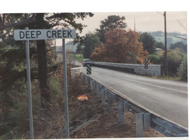 Sunbury Family History and Heritage Society Inc.
Photograph, Bulla, C 1980s
The photograph shows the approach to the Bulla Bridge at Deep Creek in the Township of Bulla. Immediately on crossing the bridge there is a sharp bend in the road and a step ascent up Bulla Hill through the cutting until level ground is reached. The photograph is looking to the NW. Deep Creek meets the Maribyrong River further downstream and closer to Keilor.The bridge and road replaced the ford crossing in 1869 that was downstream from the bridge.A coloured photograph of the approach to a bridge over the Deep Creek at Bulla along Sunbury Road. bulla bridge, deep creek, sunbury road -
 Moorabbin Air Museum
Document (item) - CAC Collection - Mr.D.J.Dalziel Documents,refer Description for further details
University of Melbourne Faculty of Economics and Commerce 1967 - The Establishment Of The Aircraft Manufacturing Industry In Australia by Ian H. Ring. The Mirage Contract Committee, 1960-61. Report On The Limitations Of Fishermans Bend Airfield 1950. The Fitzgerald Report - 1958. The Mc Grath Report For The Defence (Industrial) Committee - 1972. The Rationalisation Of The Aircraft Industry. Industries Assistance Commission Inquiry 1974-75. Parliamentary Joint Committee On Foreign Affairs And Defence , 1976 & 1978. -
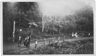 Southern Sherbrooke Historical Society Inc.
Photograph - Belgrave, Beauty Bend
B&W photo of a scene in Belgrave, taken Easter 1922 presumably by Miss Field. The view is of Beauty Bend on the Monbulk Road where it crosses a small gully. Two men and a woman are standing on the near side of the fenced-off gully, another group people, perhaps two men and four women and girls, are sitting and standing on the far side of the gully, and a further two people are at the right of the photo. There are trees and tree ferns in the background and two signs are visible, attached to trees and possibly pertaining to a guesthouse further up the hill and accessible by a path which is just visible. On the back of the photo 'Belgrave Easter 1922' is written in pen. -
 Kew Historical Society Inc
Photograph - Demolishing the Zig-Zag Bridge, 1929
Henry Beater Christian (1886-1962) , was a descendant of one of the earliest settler families in Kew. Employed at the Kew Asylum as a 'public servant', he was a skilled amateur photographer, photographing numerous scenes in Kew and on his travels around Victoria. The majority of his photographs date from 1916 to 1929. His finest photographs are housed in two photograph albums. Rare photograph of the demolition of the Zig-Zag Bridge linking the two asylums on either side of the Yarra River.Digital copy of a photograph from page 16 of the 47-page photograph album containing 261 gelatinous silver images, loaned by Diane Washfold with permission given to digitise and hold a copy in our collection. The Zig-Zag Bridge linked the grounds of the Yarra Bend and Kew Asylums. The wooden bridge was constructed in the 1870s and lasted through numerous floods until its destruction in 1929. A horizontal structure, the walkway was reached via a wooden staircase on the Kew bank of the river. The steps were required due to the different levels of the banks on this stretch of the river. This night-time photograph shows the remaining parts of the bridge being destroyed by fire."Demolishing Zig-Zag / 6. 1929"henry beater christian (1886-1962), landscape photography, kew (vic.) — yarra river, christian-washfold collection, photograph albums, zig-zag bridge -
Clunes Museum
Audio - GRAMOPHONE RECORDS
.1 Edison - On the Beach Medley/Medley of Hawaiian Airs .2 Edison - Honolulu Hula medley/Na Pua Eha .3 Decca - Rock A Bye Your Baby/A Blushin' Rose .4 Decca - Sonny Boy/Book in Your Own Backyard .5 Regal - The Man on the Flying Trapeze/Part 1 & 2 .6 Regal - Love is the Sweetest Thing/round the Bend of the road .7 Columbia - Music in the Air/Portrait of a Flirt .8 Columbia - Mamzelle ZiZi/Swing Low Sweet Chariot .9 Columbia - Poet and Peasant Overture Part 1 & 2 .10 Columbia - Toy Symphony 1 & 2edison, columbia, regal, decca, 78rpm -
 Orbost & District Historical Society
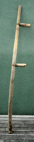
scythe handle, Early 20th century
Scythes were used with a long sweeping movement which made them much less tiring for labourers to use than reaping hooks or sickles though they still involved great physical labour and considerable skill to perfect. Both hands were in use and the operator did not have to bend his back to reach down to the crop. Scythes were not used as often on farms after the mechanisation of harvesting. They were still used for cutting awkward shaped small plots and for opening a path for the tractors. This item is an example of a tool used by the early settlers of the Orbost district. A curved wooden scythe handle with two nailed grips attached with metal rings. There is no blade. There is a metal hook at the bottom.scythe agricultural tool farming -
 Orbost & District Historical Society
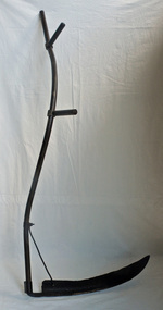
scythe, early -mid 20th century
Scythes were used with a long sweeping movement which made them much less tiring for labourers to use than reaping hooks or sickles though they still involved great physical labour and considerable skill to perfect. Both hands were in use and the operator did not have to bend his back to reach down to the crop. Scythes were not used as often on farms after the mechanisation of harvesting. They were still used for cutting awkward shaped small plots and for opening a path for the tractors. This item is an example of a tool used by the early settlers of the Orbost district.A curved iron blade with one sharp edge. It is attached to a curved hollow handle with two extensions on one side where the scythe can be held by two hands.scythe agriculture tool -
 Mortlake and District Historical Society
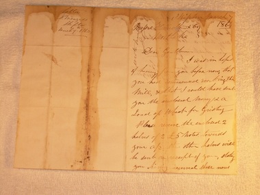
Letter for payment of account Mortlake Mill, March 7 1864
This letter was sent by a customer D. Menzies at Skipton to the Mortlake Mill, detailing an unusual payment method for the processing of his wheat into flour. David Menzies was a Scots farmer who lived in Skipton c. 1860's on a bend in the Mount Emu Creek. He helped establish the local school and a lane in the township bears his name. The letter illustrates the nature of commerce and the difficulties of communication and life generally in the country at the time. The bluestone Mortlake Mill built in 1856, has been a prominent landmark in Mortlake for over 150 years. It played a significant role in the commercial life of the town and was initially a wind-mill to process district grain for sale. The goldrush at Ararat 100 km. away led to a temporarily increased population and demand for foodstuffs. In 1857 the Mill was sold to Aikman, Hamilton and Geddes who converted it to steampower and later built the prominent chimney, which is on the Heritage Register as part of the National Estate. D. Menzies at Skipton lived at least 85 km away - his wheat which urgently needed milling, faced a slow and arduous journey by bullock dray. After the demise of the Ararat goldfields and the decline in population (as well as the district soils proving unsuitable for sustained wheat cultivation), the operation of the Mill declined too and the proprietors increased their involvement in other activities - supply of building materials, timber felling and sawmills. Despite the apparent difficulties of conducting business in the 1850's, it is notable that commerce thrived at that time in country districts, as an examination of Mill accounts and records show.Handwritten letter dated 1864 (water-stained)Skipton March 7 1864 [to] Messrs. Hamilton & Co. Mortlake. Dear Gentlemen, I was in hope of hearing from you before now that you had commenced working the Mill, & that I could have sent you the enclosed money [for a] load of wheat for Gristing. Please receive the enclosed 2 halves of 2 [two] 5 [pound sign] notes forwarded to your account. the other halves will be sent on receipt of your stating you having received those notes sent. As I am out of flour be so good as say how soon I may send a load of wheat. In haste I am Gentlemen Yours truly D. Menziesmortlake mill grain wheat hamilton geddes aikman laang dixie menzies skipton -
 Greensborough Historical Society
Photograph - Digital image, Marilyn Smith et al, Janefield Precinct: Looking down toward Kookaburra Bend 1, 27/11/2014
Looking down toward Kookaburra Bend 1. The remains of this site are between Greensborough and Janefield. A RAAF Hygiene Training Camp was located on the Plenty River, just south of the Janefield community. It was in use from 1944 to 1946. The Camp was constructed from salvaged materials. Instruction included building and maintenance of grease traps, latrines, elementary plumbing and carpentry.Early remains of a WW2 training camp Digital colour photograph. -
 Greensborough Historical Society
Photograph - Digital image, Marilyn Smith et al, Janefield Precinct: Looking down toward Kookaburra Bend 2, 27/11/2014
Looking down toward Kookaburra Bend 2. The remains of this site are between Greensborough and Janefield. A RAAF Hygiene Training Camp was located on the Plenty River, just south of the Janefield community. It was in use from 1944 to 1946. The Camp was constructed from salvaged materials. Instruction included building and maintenance of grease traps, latrines, elementary plumbing and carpentry.Early remains of a WW2 training camp Digital colour photograph. -
 Greensborough Historical Society
Photograph - Digital image, Marilyn Smith et al, Janefield Precinct: View of river bend, 27/11/2014
Janefield Precinct: View of river bend. The remains of this site are between Greensborough and Janefield. A RAAF Hygiene Training Camp was located on the Plenty River, just south of the Janefield community. It was in use from 1944 to 1946. The Camp was constructed from salvaged materials. Instruction included building and maintenance of grease traps, latrines, elementary plumbing and carpentry.Early remains of a WW2 training camp Digital colour photograph.janefield -
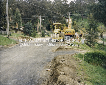 Eltham District Historical Society Inc
Photograph - Colour Print, Shire of Eltham, Quinn Estate, Sackville Street, Montmorency, c.1983
Looking northeast near 107 on left and 118 on right, intersection with Riverina Road on left at corner and Bolton Street around bend to right of image. Image dated between similar images of known dates being Sep 1982 prior to road construction works and May 1983 when kerb and channel/sealing works completed.1983, footpaths and gutters, montmorency, private street scheme, quinn estate, road construction, road drainage, road sealing, sackville street -
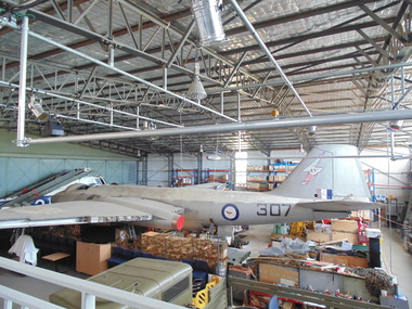 National Vietnam Veterans Museum (NVVM)
Vehicle - Canberra Bomber A84-307, 1951
The bomber being restored is the oldest surviving complete Canberra. This plane flew continually from 1951 —1973 and was used in both Malaya and Vietnam. It is one of three bombers bought from England before production began at the Government Aircraft Factory at Fisherman's Bend. The plane has the oldest known Rolls Royce Avon engine, being serial number 2.The Canberra is a first-generation jet-powered light bomber which could fly at a higher altitude than previous bombers. It was Australia's first jet bomber. B1 bomber version of the English Electric Canberra. It is being restored by the NVVM.Serial no: A84-307.canberra bomber, air force, bomber, plane -
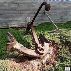 Flagstaff Hill Maritime Museum and Village
Equipment - Anchor, John Trotman, 1852 to early 1900s
This Trotman’s pattern stock anchor is the southernmost anchor on display at Flagstaff Hill’s Anchor Graveyard. This large Trotman design anchor was patented in 1852 by John Trotman and was widely used on merchant ships. On April 15th 2001 around midday this anchor was raised from the seabed of Lady Bay, Warrnambool, by the crew from Birdon Dredging, who had been hired to dredge the Harbour. The spokesperson Steve Walker, who worked for the firm, said that the anchor and long chain were found after the chain became tangled in the cutter blade of the dredging equipment. The anchor was lifted from the water and onto the Breakwater then a front-end loader placed it onto a truck that then delivered it to Flagstaff Hill Maritime Museum & Village. Howard Nichol, Museum Manager at the time, had estimated the anchor to be up to 130 years old. The previous Museum Manager, Peter Ronald, who was also a diver, had identified the anchor as a Trotman’s type and similar to those used on some of the major wrecks in the region. According to Nicholl, Museum staff believed it was possible that the anchor is one of two used as a mooring line that had been used to catch driving vessels and prevent ships from washing aground on the sand bar. The mooring line was shown as a dotted line on the 1890 chart of Lady Bay, approved by Lieutenant Stanley of the British Admiralty. by Lieutenant Stanley [British Admiralty]. The location of the anchor corresponds to a point on that map and the length of the chain supports that theory. “The map is quite a detailed survey of the Bay and it shows two anchors with buoys on the ends with probably about 100 yards of chain stretched between them. The ships would drop anchor and was the chain as a snag because this was a treacherous bay before the Breakwater was built and this was a way to eliminate that problem, "said Nichol. The mooring chain was put in place to catch drifting vessels during wild stormy weather. It was identified. ABOUT TROTMAN’S ANCHORS- The British Admiralty wanted an anchor design that had more holding power. The Committee of 1852 on Anchors was appointed to assess and report on the qualities of various anchors including Trotman’s anchors. Trotman’s pattern anchor received the highest score. The anchor is similar to the Admiral’s design but features arms that pivot when the anchor settles and the upper fluke moves to rest against the shank. The anchor then sits lower, which in turn greatly reduces the chances of the anchor’s chain, cable or rope getting tangled. The top of the shank has a fitting that allows a quick release of the anchor’s chain if this becomes necessary. This Trotman’s anchor is significant as a part of the maritime history of the Port of Warrnambool regardless of whether it belonged to one of the 29 ships that were stranded or wrecked in Lady Bay. The anchor is connected to the many attempts to maintain Warrnambool as a safe and manageable port, including the various plans for the construction of the Breakwater.Anchor: an iron Trotman’s pattern style with a rectangular-section shank that is wider in the middle and has a base that extends on two opposite sides in a ‘fork prong’ manner. A crescent-shaped, double-ended arm is fitted into the base of the shank with a bolt, enabling it to pivot. Each arm has a fluke in the shape of an upward palm with an attached metal plate that forms a horn at the back of the palm. A long, round-section pipe is fitted to the top of the shank at 90 degrees to the arms; one side has an elbow bend parallel to the arms, and both ends have an attached metal sphere. The pivoting ring at the top of the shank can be lifted for a quick release of the chain.flagstaff hill, warrnambool, maritime village, maritime museum, shipwreck coast, great ocean road, anchor, mooring, trotman, lady bay, breakwater, admiralty, ship equipment, stock anchor, john trotman, 1852 patent, 2001, birdon dredging, steve walker, howard nichol, peter ronald, british admiralty, lieutenant stanley, committee of 1852 on anchors -
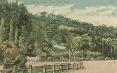 Bendigo Historical Society Inc.
Postcard - GLADYS DEAN COLLECTION: POSTCARD, 1906 - 1908
Printed coloured postcard depicting Devils Elbow Adelaide. Image is of a country road sharp bend set against a thickly treed hillside. A white gate, parts of a white fence, a horse and cart and another cart can be seen on the far edge of the road. A post and rail fence and power pole are in the foreground. The words Devils Elbow Near Adelaide S.A. are printed in red across the top edge. On the reverse card is addressed to Miss R Dean 'Esmond' Golden Square Victoria and a one penny stamp is affixed and postmarked Adelaide. Handwriting is on one side. The words South Australian Post Card Commonwealth of Australia are printed on the top.postcard -
 Kew Historical Society Inc
Photograph - Zig-Zag Bridge, 1924
Henry Beater Christian (1886-1962) , was a descendant of one of the earliest settler families in Kew. Employed at the Kew Asylum as a 'public servant', he was a skilled amateur photographer, photographing numerous scenes in Kew and on his travels around Victoria. The majority of his photographs date from 1916 to 1929. His finest photographs are housed in two photograph albums. Digital copy of a photograph from page 8 of the 47-page photograph album containing 261 gelatinous silver images, loaned by Diane Washfold with permission given to digitise and hold a copy in our collection. The Zig-Zag Bridge linked the grounds of the Yarra Bend and Kew Asylums. The wooden bridge was constructed in the 1870s and lasted through numerous floods until its destruction in 1929. A horizontal structure, the walkway was reached via a wooden staircase on the Kew bank of the river. The steps were required due to the different levels of the banks on this stretch of the river. The photo is taken from the Kew side of the river and shows clearly the width of the walkway on top of the bridge. "Zig-Zag Bridge"henry beater christian (1886-1962), landscape photography, kew (vic.) — yarra river, christian-washfold collection, photograph albums, zig-zag bridge -
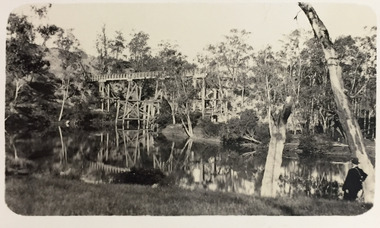 Kew Historical Society Inc
Photograph - Demolishing the Zig-Zag Bridge, 1929
Henry Beater Christian (1886-1962) , was a descendant of one of the earliest settler families in Kew. Employed at the Kew Asylum as a 'public servant', he was a skilled amateur photographer, photographing numerous scenes in Kew and on his travels around Victoria. The majority of his photographs date from 1916 to 1929. His finest photographs are housed in two photograph albums. Rare photograph of the demolition of the Zig-Zag Bridge linking the two asylums on either side of the Yarra River.Digital copy of a photograph from page 16 of the 47-page photograph album containing 261 gelatinous silver images, loaned by Diane Washfold with permission given to digitise and hold a copy in our collection. The Zig-Zag Bridge linked the grounds of the Yarra Bend and Kew Asylums. The wooden bridge was constructed in the 1870s and lasted through numerous floods until its destruction in 1929. A horizontal structure, the walkway was reached via a wooden staircase on the Kew bank of the river. The steps were required due to the different levels of the banks on this stretch of the river. This is a photo of the bridge before part of it was destroyed in a flood in 1929. A man, perhaps Henry Christian, stands at the right of the foreground."Demolishing Zig-Zag / 6. 1929"henry beater christian (1886-1962), landscape photography, kew (vic.) — yarra river, christian-washfold collection, photograph albums, zig-zag bridge -
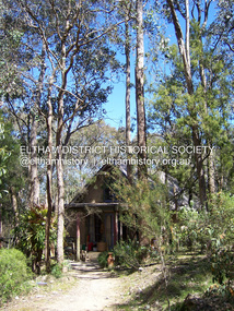 Eltham District Historical Society Inc
Photograph - Digital Photograph, Marguerite Marshall, Neil Douglas house, Bend Of Islands, 3 October 2006
Mud brick house first owned by naturalist and artist Neil Douglas and Helen (Abbie) Heathcote at the Bend of Islands. They were original residents in the 1970s. This house is on the Victorian Heritage Database and is considered locally significant. Covered under Heritage Overlay, Nillumbik Planning Scheme Published: Nillumbik Now and Then / Marguerite Marshall 2008; photographs Alan King with Marguerite Marshall.; CoverThis collection of almost 130 photos about places and people within the Shire of Nillumbik, an urban and rural municipality in Melbourne's north, contributes to an understanding of the history of the Shire. Published in 2008 immediately prior to the Black Saturday bushfires of February 7, 2009, it documents sites that were impacted, and in some cases destroyed by the fires. It includes photographs taken especially for the publication, creating a unique time capsule representing the Shire in the early 21st century. It remains the most recent comprehenesive publication devoted to the Shire's history connecting local residents to the past. nillumbik now and then (marshall-king) collection, bend of islands, neil douglas house, neil douglas -
Port Melbourne Historical & Preservation Society
Pamphlet - Beacon Cove to Webb Trail 2016, Pat Grainger, Walks around Vintage Port No.6, Jun 2016
Walks Around Vintage Port No 6. Supported by CoPP. Walk No 6 was originally reserved for Bend on the River: Westgate Park. The Westgate Park walk was not produced so the updated versions the Pub walk in 2001 and 2012 became No 6 however with the introduction of this Beacon Cove to Webb Trail as a new Walk No 6 in 2016, the 2017 version of the Pub walk reverted to No 7.Port Melbourne Historical and Preservation Society publication, "Walks around Vintage Port", No.6 Beacon Cove to Webb Trail 2016 Editionbuilt environment, piers and wharves - webb dock, beacon cove -
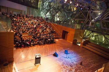 Emerging Writers' Festival
2013 Festival Photographs
The 2013 Emerging Writers' Festival ran from May 23rd until June 2nd, 2013. The festival was held in Melbourne and offered 68 events across 11 days. Program highlights include the Writers' Town Hall Conference, the late night literary programming at new Festival Hub 1000 £ Bend and the health and well-being focused Writers' Retreat at Abbotsford Convent.A collection of digital photographs associated with the 2013 Emerging Writers' Festival. All photographed within this sample were taken by photographer mark Gambino.10th emerging writers' festival, sam twyford-moore, 2013, program, the wheeler centre, emerging writers', literary, anniversary, literary festival, melbourne, abbotsford convent, -
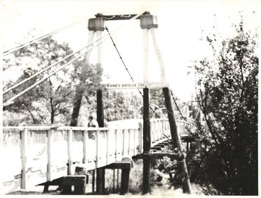 Kew Historical Society Inc
Photograph - Photograph (copy), Kanes Bridge, Studley Park, 195-1955
In 1928 a footbridge was erected to link Kew with the public golf course across the Yarra. The total cost of construction came to 250 pounds and the bridge became known as Kane's Bridge. During the 1934 floods the bridge was washed downstream, and was subsequently rebuilt. The present form of the bridge resembles the earlier bridge which crossed from the Yarra Bend Asylum to Kew, further upstream. (VHD)This work forms part of the collection assembled by the historian Dorothy Rogers, that was donated to the Kew Historical Society by her son John Rogers in 2015. The manuscripts, photographs, maps, and documents were sourced by her from both family and local collections or produced as references for her print publications. Many were directly used by Rogers in writing ‘Lovely Old Homes of Kew’ (1961) and 'A History of Kew' (1973), or the numerous articles on local history that she produced for suburban newspapers. Most of the photographs in the collection include detailed annotations in her hand. The Rogers Collection provides a comprehensive insight into the working habits of a historian in the 1960s and 1970s. Together it forms the largest privately-donated collection within the archives of the Kew Historical Society.A photographic copy of an older photograph of Kanes Bridge."Kanes Bridge"kanes bridge, yarra river, bridges - kew (vic.) -
 Kew Historical Society Inc
Photograph - Kane's Bridge on the Yarra River, December 1934
In 1928 a footbridge was erected to link Kew with the public golf course across the Yarra. The total cost of construction came to 250 pounds and the bridge became known as Kane's Bridge. During the 1934 floods the bridge was washed downstream, and was subsequently rebuilt. The present form of the bridge resembles the earlier bridge which crossed from the Yarra Bend Asylum to Kew, further upstream. (VHD)Original, black and white positive of Kane's Bridge in December 1934, when the 'great flood' of the Yarra caused the bridge's destruction. Inscribed verso: "Kane's Bridge Yarra in flood Dec 1934"river yarra, yarra -- kew (vic.), kanes bridge, 1934 floods -
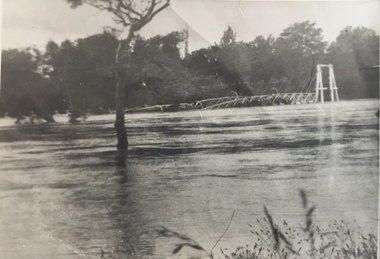 Kew Historical Society Inc
Photograph - Kane's Bridge destroyed by the 1934 Flood, 1934
In 1928 a footbridge was erected to link Kew with the public golf course across the Yarra. The total cost of construction came to 250 pounds and the bridge became known as Kane's Bridge. During the 1934 floods the bridge was washed downstream, and was subsequently rebuilt. The present form of the bridge resembles the earlier bridge which crossed from the Yarra Bend Asylum to Kew, further upstream. (VHD)Black and white positive print (identical to 2021.70 but with a different annotation) showing the destruction of Kane's Bridge in the floods of 1934. The Kodak paper would indicate a 1950s reprinting.Annotation verso: "Kane's Bridge in 1934 flood / Dec. 1934.kane's bridge, river yarra, yarra valley, 1934 floods -
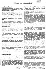 Greensborough Historical Society
Article - Article, Newsletter, Janeen O'Connell, William and Margaret Blay, by Janeen O'Connell, 2022
The Blays moved from their farm in New Norfolk, Van Diemens Land to an allotment at Greenhills on the Plenty River in 1841, but William was injured in a fall and was unable to work this farm, which was repossessed by the bank, causing him to fall into a severe depression and subsequently admitted to Yarra Bend Insane Asylum, where he died in 1849. Article first published in "Pioneer Echo" no 226, Oct-Nov 2022.1 p. typescript, copied from newsletterblay family, william blay, greenhills -
Port Melbourne Historical & Preservation Society
Pamphlet - The Pubs of Port 2017, Pat Grainger, Walks around Vintage Port No.7, Apr 2017
Update and reprint of Pubs of Port Walk. Supported by CoPP. The original Pubs in Port Walk was No 7 with No 6 reserved for Bend on the River: Westgate Park. The Westgate Park walk was not produced so the updated versions the Pub walk in 2001 and 2012 became No 6 however with the introduction of a Beacon Cove to Webb Trail as a new Walk No 6 in 2016, this version of the Pub walk (2017) reverted to No 7.Port Melbourne Historical and Preservation Society publication, "Walks around Vintage Port", "No.7 Pubs of Port" 2017 Edition.hotels, built environment