Showing 570 items
matching boundary road
-
 City of Greater Bendigo - Civic Collection
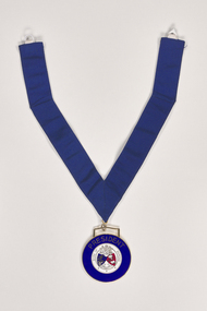
Ceremonial object - Shire of Marong President Medallion, P Blashki & Sons
The first local government authority for Marong was the Marong Road District (an early form of single-purpose local government), which was proclaimed on 19 August 1860. Its boundary was altered twice in 1862 and on 12 December 1864 it was re designated as a shire. It absorbed Raywood Borough in 1915, and was proclaimed a Rural City in 1990. On 2 December 1994, with the creation of Greater Bendigo City Council, it was abolished by being amalgamated with Bendigo City, Eaglehawk Borough, Huntly Shire, part of McIvor Shire, part of Metcalfe Shire and Strathfieldsaye Shire to form Greater Bendigo City.Manufactured by Blashki and Son this circular medal hangs from a royal blue gosgrain ribbon. The medallion has a gold edging with blue enamel outer band. Centre depicts Australia coat of arms and the Shire of Marong coat of arms.PRESIDENT / SHIRE OF MARONG / DIEU ET MON DROIT / INDUSTRIAshire of marong, marong presidents medal, city of greater bendigo ceremonial item -
 Wodonga & District Historical Society Inc
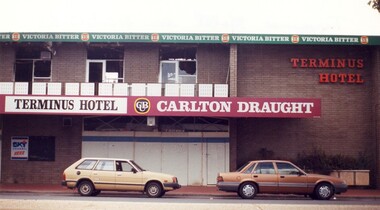
Photograph - Terminus Hotel Wodonga Fire 1998, C. 1998
The Terminus Hotel, Wodonga was built by James Thompson Hatch in 1873, the same year the railway reached Wodonga from Melbourne. It was named due to its close proximity to the railway terminus. It was sold to Messrs George Day and Kenneth McLennan of Albury. It was first licenced to J.G. Morton in January 1874. Annie Allen, from Ireland, took over as licensee of the hotel containing 14 rooms in 1879, after she and her husband, George James Allen, purchased it. In 1887 they added a new wing on the south boundary of the property next to Peter McLean’s store at 81 Sydney Road. The architects for the new wing were Gordon and Gordon. A billiard room, a dining room, and 18 other rooms were added on the vacant block of land between the Hotel and the Bank of Victoria. A balcony 6 feet wide was added on the north side. Included in the plans was the latest patent elevator, later known as a dumb waiter. Allen died in 1889 aged 52, and Annie Allen continued to run the Terminus. She later married John G. Haldon and was licensee of the hotel until December 1898 when the licence was transferred to William Carkeek. Carkeek, from Cornwall, arrived in the colony around 1860 and is considered one of the founders of Tallangatta. In November 1903, the license was transferred to Daniel Crawford, then in 1906 it was transferred to Mr Stephen Carkeek. In 1916 it passed into the hands of Mr H. W. Allen of Rutherglen, son of Mr George James Allen. On 1st June 1998 the Terminus Hotel was destroyed by fire. Estimates of damage range from between a conservative $750,000 to as high as $2 million. The remains of the building were demolished in 1999.The Terminus Hotel was one of the earliest hotels in Wodonga with clear links to the establishment of the railway line. It was an important business and meeting place for social gatherings. On 1st June 1998 the Terminus Hotel was destroyed by fire. Estimates of damage range from between a conservative $750,000 to as high as $2 million. The remains of the building were demolished in 1999. These images capture the extent of damage prior to the demolition. -
 Kew Historical Society Inc
Photograph - Civic event in Stradbroke Park, 1976
Stradbroke Park. Extent: Kilby Road to Harp Road at Burke Road. Historical Documentation: 1851 - Portion 91 purchased by Edward Glynn; 1888 - The Harp of Erin Estate (which included Section 91) offered for sale; 1896 - The area now known as Stradbroke Park was bisected by a creek that flowed from the Yarra via Hay's Paddock (q.v.) and extended through to Burke Road; 1943 - W.D. Birrell, Town Clerk of Kew, proposed that the creek be filled and a reserve created; 1954 - Entire area designated as 'open space' and named 'Stradbroke Park'. The line of the creek that ran through the Park created a further reserve on the north side of High Street, now known as 'Harrison Reserve'. Existing Condition: The park is largely of mown grass that has mature trees set into it It is possible that a number of these are remnant of the original vegetation, while there are also a number of exotic trees introduced, particularly at the northern end of the park. The southern end is dominated by playing fields. (Source: Sanderson, P 1988. Kew Conservation Study)Colour photographic positive (with colour degradation) of sporting teams at a civic event in Stradbroke Park in Kew East in May 1976. The event was officiated by the Mayor of Kew, Cr Alan Hutchinson. Sporting teams in uniform included: footballers, athletes, cricketers, hockey players. Stradbroke Park is situated on the western boundary of Kew at Burke and Harp Roads.stradbroke park, cr alan hutchinson, team sports -- kew (vic.) -
 Kew Historical Society Inc
Photograph - Civic event in Stradbroke Park, 1976
Stradbroke Park. Extent: Kilby Road to Harp Road at Burke Road. Historical Documentation: 1851 - Portion 91 purchased by Edward Glynn; 1888 - The Harp of Erin Estate (which included Section 91) offered for sale; 1896 - The area now known as Stradbroke Park was bisected by a creek that flowed from the Yarra via Hay's Paddock (q.v.) and extended through to Burke Road; 1943 - W.D. Birrell, Town Clerk of Kew, proposed that the creek be filled and a reserve created; 1954 - Entire area designated as 'open space' and named 'Stradbroke Park'. The line of the creek that ran through the Park created a further reserve on the north side of High Street, now known as 'Harrison Reserve'. Existing Condition: The park is largely of mown grass that has mature trees set into it It is possible that a number of these are remnant of the original vegetation, while there are also a number of exotic trees introduced, particularly at the northern end of the park. The southern end is dominated by playing fields. (Source: Sanderson, P 1988. Kew Conservation Study)Colour photographic positive (with colour degradation) of sporting teams at a civic event in Stradbroke Park in Kew East in May 1976. The event was officiated by the Mayor of Kew, Cr Alan Hutchinson. Stradbroke Park is situated on the western boundary of Kew and bordered by Burke and Harp Roads.stradbroke park, cr alan hutchinson, team sports -- kew (vic.) -
 Wodonga & District Historical Society Inc
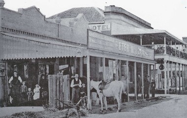
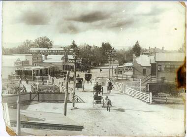
Photograph - Peter McLean's General Store and the Terminus Hotel, Wodonga, C. 1874
The Terminus Hotel, Wodonga was built by James Thompson Hatch in 1873, the same year the railway reached Wodonga from Melbourne. It was named due to its close proximity to the railway terminus. It was sold to Messrs George Day and Kenneth McLennan of Albury. It was first licenced to J.G. Morton in January 1874. Annie Allen, from Ireland, took over as licensee of the hotel containing 14 rooms in 1879, after she and her husband, George James Allen, purchased it. In 1887 they added a new wing on the south boundary of the property next to Peter McLean’s store at 81 Sydney Road. The architects for the new wing were Gordon and Gordon. A billiard room, a dining room, and 18 other rooms were added on the vacant block of land between the Hotel and the Bank of Victoria. A balcony 6 feet wide was added on the north side. Included in the plans was the latest patent elevator, later known as a dumb waiter. Allen died in 1889 aged 52, and Annie Allen continued to run the Terminus. She later married John G. Haldon and was licensee of the hotel until December 1898 when the licence was transferred to William Carkeek. Carkeek, from Cornwall, arrived in the colony around 1860 and is considered one of the founders of Tallangatta. In November 1903, the license was transferred to Daniel Crawford, then in 1906 it was transferred to Mr Stephen Carkeek. In 1916 it passed into the hands of Mr H. W. Allen of Rutherglen, son of Mr George James Allen. Between 1916 and 1933 there were a variety of licensees. In October 1933, the stables and garage at the rear of the Terminus Hotel were totally destroyed by fire. In 1935, the Terminus again underwent a series of improvements and extensions at the cost of £3,000. The front of the premises was extended in the fashionable Spanish mission style. The balcony of brick and concrete was extended to be 18 feet wide, wire gauged and fitted with glass slides and a tile roof. In addition to 15 new bedrooms, four more bathrooms, making seven in all, were available for patrons. These were on the second floor, while beneath them provision was made for four shops and a new kitchen and a laundry. Throughout the 1930s and 1990s the licensee and owners changed several times. On 1st June 1998 the Terminus Hotel was destroyed by fire. Estimates of damage range from between a conservative $750,000 to as high as $2 million. The remains of the building were demolished in 1999.The Terminus Hotel was one of the earliest hotels in Wodonga with clear links to the establishment of the railway line. It was an important business and meeting place for social gatherings.Oldest available photo of the Terminus Hotel beside Peter McLean's Wholesale and Family Drapers General Store. These buildings were on the west side of Sydney Road, later renamed to High Street.hotels wodonga, businesses wodonga, terminus hotel wodonga -
 Wodonga & District Historical Society Inc
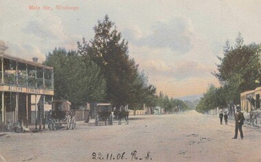
Photograph - Terminus Hotel, Wodonga, C. 1906
The Terminus Hotel, Wodonga was built by James Thompson Hatch in 1873, the same year the railway reached Wodonga from Melbourne. It was named due to its close proximity to the railway terminus. It was sold to Messrs George Day and Kenneth McLennan of Albury. It was first licenced to J.G. Morton in January 1874. Annie Allen, from Ireland, took over as licensee of the hotel containing 14 rooms in 1879, after she and her husband, George James Allen, purchased it. In 1887 they added a new wing on the south boundary of the property next to Peter McLean’s store at 81 Sydney Road. The architects for the new wing were Gordon and Gordon. A billiard room, a dining room, and 18 other rooms were added on the vacant block of land between the Hotel and the Bank of Victoria. A balcony 6 feet wide was added on the north side. Included in the plans was the latest patent elevator, later known as a dumb waiter. Allen died in 1889 aged 52, and Annie Allen continued to run the Terminus. She later married John G. Haldon and was licensee of the hotel until December 1898 when the licence was transferred to William Carkeek. Carkeek, from Cornwall, arrived in the colony around 1860 and is considered one of the founders of Tallangatta. In November 1903, the license was transferred to Daniel Crawford, then in 1906 it was transferred to Mr Stephen Carkeek. In 1916 it passed into the hands of Mr H. W. Allen of Rutherglen, son of Mr George James Allen. Between 1916 and 1933 there were a variety of licensees. In October 1933, the stables and garage at the rear of the Terminus Hotel were totally destroyed by fire. In 1935, the Terminus again underwent a series of improvements and extensions at the cost of £3,000. The front of the premises was extended in the fashionable Spanish mission style. The balcony of brick and concrete was extended to be 18 feet wide, wire gauged and fitted with glass slides and a tile roof. In addition to 15 new bedrooms, four more bathrooms, making seven in all, were available for patrons. These were on the second floor, while beneath them provision was made for four shops and a new kitchen and a laundry. Throughout the 1930s and 1990s the licensee and owners changed several times. On 1st June 1998 the Terminus Hotel was destroyed by fire. Estimates of damage range from between a conservative $750,000 to as high as $2 million. The remains of the building were demolished in 1999.The Terminus Hotel was one of the earliest hotels in Wodonga with clear links to the establishment of the railway line. It was an important business and meeting place for social gatherings.Allen's Terminus Hotel in Main Street (known as Sydney Road and later High Street, Wodonga). This image is dated as November 1906, however research suggests the hotel was operated by the Carkeek family and then and also Mr. Daniel Crawford prior to this date. The Terminus was sold by auction on 5th March 1909 as part the estate of Annie Haldon. Annie Allen had married John George Haldon in 1890.Across front of building "ALLENS TERMINUS HOTEL"hotels wodonga, businesses wodonga, terminus hotel wodonga -
 Wodonga & District Historical Society Inc
Photograph - Carkeek's Terminus Hotel, Wodonga, C. 1906 - 1909
The Terminus Hotel, Wodonga was built by James Thompson Hatch in 1873, the same year the railway reached Wodonga from Melbourne. It was named due to its close proximity to the railway terminus. It was sold to Messrs George Day and Kenneth McLennan of Albury. It was first licenced to J.G. Morton in January 1874. Annie Allen, from Ireland, took over as licensee of the hotel containing 14 rooms in 1879, after she and her husband, George James Allen, purchased it. In 1887 they added a new wing on the south boundary of the property next to Peter McLean’s store at 81 Sydney Road. The architects for the new wing were Gordon and Gordon. A billiard room, a dining room, and 18 other rooms were added on the vacant block of land between the Hotel and the Bank of Victoria. A balcony 6 feet wide was added on the north side. Included in the plans was the latest patent elevator, later known as a dumb waiter. Allen died in 1889 aged 52, and Annie Allen continued to run the Terminus. She later married John G. Haldon and was licensee of the hotel until December 1898 when the licence was transferred to William Carkeek. Carkeek, from Cornwall, arrived in the colony around 1860 and is considered one of the founders of Tallangatta. In November 1903, the license was transferred to Daniel Crawford, then in 1906 it was transferred to Mr Stephen Carkeek. In 1916 it passed into the hands of Mr H. W. Allen of Rutherglen, son of Mr George James Allen. On 1st June 1998 the Terminus Hotel was destroyed by fire. Estimates of damage range from between a conservative $750,000 to as high as $2 million. The remains of the building were demolished in 1999.The Terminus Hotel was one of the earliest hotels in Wodonga with clear links to the establishment of the railway line. It was an important business and meeting place for social gatherings.On 21 December 1898 an application to transfer the license of the Terminus Hotel from Mrs Annie Haldon to Mr William Carkeek was lodged This was granted by the Wodonga Licensing Court on 12 January 1899. In February of that year, it was transferred to Mrs. Rebecca Carkeek. William Carkeek died on 17 March 1900, aged 57 years. In November 1900 Mr. Daniel Crawford took over the license. In March 1906, the Carkeek family returned to the Terminus Hotel when their son Stephen purchased the business. In January 1909, tenders were invited for Freehold Purchase of the property. It was available on a 7 year lease at a rental of £9 per week In 1913 Stephen Carkeek disposed of the goodwill of the business to Mr Wilson of Grenfell, New South Wales, thus ending the Carkeek family’s long association with the Terminus Hotel. He died in Beechworth on 16 May 1928.Across side of building "CARKEEK'S TERMINUS FAMILY HOTEL"hotels wodonga, businesses wodonga, terminus hotel wodonga, william carkeek -
 Wodonga & District Historical Society Inc
Photograph - Terminus Hotel and Pares House, 1996
The Terminus Hotel, Wodonga was built by James Thompson Hatch in 1873, the same year the railway reached Wodonga from Melbourne. It was named due to its close proximity to the railway terminus. It was sold to Messrs George Day and Kenneth McLennan of Albury. It was first licenced to J.G. Morton in January 1874. Annie Allen, from Ireland, took over as licensee of the hotel containing 14 rooms in 1879, after she and her husband, George James Allen, purchased it. In 1887 they added a new wing on the south boundary of the property next to Peter McLean’s store at 81 Sydney Road. The architects for the new wing were Gordon and Gordon. A billiard room, a dining room, and 18 other rooms were added on the vacant block of land between the Hotel and the Bank of Victoria. A balcony 6 feet wide was added on the north side. Included in the plans was the latest patent elevator, later known as a dumb waiter. Allen died in 1889 aged 52, and Annie Allen continued to run the Terminus. She later married John G. Haldon and was licensee of the hotel until December 1898 when the licence was transferred to William Carkeek. Carkeek, from Cornwall, arrived in the colony around 1860 and is considered one of the founders of Tallangatta. In November 1903, the license was transferred to Daniel Crawford, then in 1906 it was transferred to Mr Stephen Carkeek. In 1916 it passed into the hands of Mr H. W. Allen of Rutherglen, son of Mr George James Allen. On 1st June 1998 the Terminus Hotel was destroyed by fire. Estimates of damage range from between a conservative $750,000 to as high as $2 million. The remains of the building were demolished in 1999.The Terminus Hotel was one of the earliest hotels in Wodonga with clear links to the establishment of the railway line. It was an important business and meeting place for social gatherings.In 1879, the Terminus Hotel was purchased by Annie and George Allen. The hotel was advertised as a two storey brick building with bar, large dining and four rooms on the ground floor, all and commodious cellar. Upstairs a large parlour and 13 bedrooms. There was also a four-roomed weatherboard cottage, a blacksmith's shop and other buildings. The Allens had about 20 years of ownership, with Annie continuing to hold the licence under her new married name of Annie Haldon after George had died in 1889. In 1888, the Allens undertook extensive additions and renovations. Annie remained as the proprietor of the building until her death in 1904, but the business was leased to William Carkeek in December 1898. The building was eventually auctioned as part of the finalising of Annie's estate in 1909.hotels wodonga, businesses wodonga, terminus hotel wodonga -
 Whitehorse Historical Society Inc.
Map, Aston, 1989
Map of the Commonwealth Electoral Division of Aston. Scale 1:25,000Map of the Commonwealth Electoral Division of Aston. Scale 1:25,000Map of the Commonwealth Electoral Division of Aston. Scale 1:25,000electoral boundaries, aston (commonwealth electoral division) -
Whitehorse Historical Society Inc.
Map, Bruce, 1989
Map of the Commonwealth Electoral Division of BruceMap of the Commonwealth Electoral Division of BruceMap of the Commonwealth Electoral Division of Bruceelectoral boundaries, bruce (commonwealth electoral division) -
Whitehorse Historical Society Inc.
Map, Chisholm, 1989
Map of the Commonwealth Electoral Division of Chisholm. Scale 1:25,000.Map of the Commonwealth Electoral Division of Chisholm. Scale 1:25,000.Map of the Commonwealth Electoral Division of Chisholm. Scale 1:25,000.electoral boundaries, chisholm (commonwealth electoral division) -
Whitehorse Historical Society Inc.
Map, Deakin, 1989
Map of the Commonwealth Electoral Division of Deakin. Scale 1:25000.Map of the Commonwealth Electoral Division of Deakin. Scale 1:25000.Map of the Commonwealth Electoral Division of Deakin. Scale 1:25000.electoral boundaries, deakin (commonwealth electoral division) -
Whitehorse Historical Society Inc.
Map, Deakin, 1977
Map of the Commonwealth Electoral Division of Deakin. Scale 1: 25,000.Map of the Commonwealth Electoral Division of Deakin. Scale 1: 25,000.Map of the Commonwealth Electoral Division of Deakin. Scale 1: 25,000.electoral boundaries, deakin (commonwealth electoral division), australia. parliament -
Whitehorse Historical Society Inc.
Map, Proposed suburb names, 1999
Whitehorse City Council: proposed suburb names and boundaries. Version 3.1Whitehorse City Council: proposed suburb names and boundaries. Version 3.1Whitehorse City Council: proposed suburb names and boundaries. Version 3.1city of whitehorse, suburb names -
Whitehorse Historical Society Inc.
Map, Legislative Council - Electoral Provinces, 1991
State of Victoria. Legislative Council Electoral Provinces. Sheet 3 Metropolitan Map. 1990 - 1991 redivision.State of Victoria. Legislative Council Electoral Provinces. Sheet 3 Metropolitan Map. 1990 - 1991 redivision.State of Victoria. Legislative Council Electoral Provinces. Sheet 3 Metropolitan Map. 1990 - 1991 redivision.electoral boundaries, victoria. parliament. legislative council -
Whitehorse Historical Society Inc.
Map, State Electoral Districts, 1978
State Electoral Districts [Melbourne] 1975. Redivision (1977 subdivisions0. Scale 1: 90,000State Electoral Districts [Melbourne] 1975. Redivision (1977 subdivisions0. Scale 1: 90,000State Electoral Districts [Melbourne] 1975. Redivision (1977 subdivisions0. Scale 1: 90,000electoral boundaries, victoria. parliament. legislative assembly -
Whitehorse Historical Society Inc.
Map, State Electoral Provinces, 1978
State Electoral Provinces 1975 redivision (1977 subdivisions) Scale 1:90,0000State Electoral Provinces 1975 redivision (1977 subdivisions) Scale 1:90,0000State Electoral Provinces 1975 redivision (1977 subdivisions) Scale 1:90,0000victoria. parliament. legislative council, electoral boundaries -
Whitehorse Historical Society Inc.
Map, Legislative Assembly, 1984
State of Victoria Legislative Assembly electoral districts 1983 - 1984 redivision (Melbourne Metropolitan area) Scale 1:50,000State of Victoria Legislative Assembly electoral districts 1983 - 1984 redivision (Melbourne Metropolitan area) Scale 1:50,000State of Victoria Legislative Assembly electoral districts 1983 - 1984 redivision (Melbourne Metropolitan area) Scale 1:50,000victoria. parliament. legislative assembly, electoral boundaries -
Whitehorse Historical Society Inc.
Map, Aerial maps, 2/04/1966 12:00:00 AM
Melbourne 1966 project, runs 10A and 11A, lens 122 151.75 mm 9,800. Photo nos 77, 107, 109, 161, 163, 165.Melbourne 1966 project, runs 10A and 11A, lens 122 151.75 mm 9,800. Photo nos 77, 107, 109, 161, 163, 165. Areas and boundaries: Map no 77 W. Park and Cook Roads; E. Dubon Rd; N Oban Rd; S Reilly St. Map No 107. W. Indra Rd and Pakenham St; E. Rooks Rd & McLares Rd; N. Maroondah Hwy; S. Hawthorn Rd & Eley Rd. Map No 109 W. Elgar Rd. E. Blackburn Rd & McKean St; S. Eley Rd & Burwood Hwy. Map No 161. W. Elgar Rd & Huntingdale Rd; E. Blackburn Rd; N. Burwood Hwy; S. Waverley Rd. Map No 163. W. Blackburn Rd; S. Springvale Rd; N. Eley Rd & Hawthorn Rd; S. Glen Waverley Railway Line. Map No 165. W. Stanley Rd, Vermont South; E. Cathies Lane, Wantirna South; N. North of Burwood Hwy; S. High Street. Melbourne 1966 project, runs 10A and 11A, lens 122 151.75 mm 9,800. Photo nos 77, 107, 109, 161, 163, 165. aerial photographs, blackburn, blackburn south, forest hill, nunawading, box hill, burwood, burwood east, donvale, mount waverley, glen waverley, wantirna, vermont south, mitcham, ringwood north, ringwood -
Whitehorse Historical Society Inc.
Document, Shire of Blackburn and Mitcham, 1926
By-laws nominating boundaries of ridings and 'Populous areas'.By-laws nominating boundaries of ridings and 'Populous areas'.By-laws nominating boundaries of ridings and 'Populous areas'.local government, shire of blackburn and mitcham -
Whitehorse Historical Society Inc.
Article, Joint swimming pool proposed, 1967
Nunawading Council is to ask Doncaster and Templestowe Council to consider the construction of a swimming pool near the boundary of the two cities.Nunawading Council is to ask Doncaster and Templestowe Council to consider the construction of a swimming pool near the boundary of the two cities. The proposal came from Cr Keith Rooney.Nunawading Council is to ask Doncaster and Templestowe Council to consider the construction of a swimming pool near the boundary of the two cities. city of nunawading, city of doncaster and templestowe., swimming pools. -
Whitehorse Historical Society Inc.
Article, Thousands switch seats; Deakin spills east, 1968
Photocopy of article about an electoral redistribution which transfers part of Box Hill from Bruce to Deakin.Photocopy of article about an electoral redistribution which transfers part of Box Hill from Bruce to Deakin. The changes also affect Blackburn, East Burwood, Forest Hill, Vermont and Heatherdale.Photocopy of article about an electoral redistribution which transfers part of Box Hill from Bruce to Deakin. electoral boundaries, box hill, blackburn, burwood east, forest hill, vermont, heatherdale, jarman, alan -
Whitehorse Historical Society Inc.
Map, Nunawading Shire, 1892
... Covers Middleborough Road to Ringwood boundary. One map... boundary. One map (Blackburn) from north of Whitehorse Road.... Covers Middleborough Road to Ringwood boundary. One map ...Photocopy of an enlargement of map of Shire of Nunawading showing landowners in 1892.Photocopy of an enlargement of map of Shire of Nunawading showing landowners in 1892. Covers Middleborough Road to Ringwood boundary. One map (Blackburn) from north of Whitehorse Road to Highbury Road, 2nd map (Mitcham) Bulleen to south of Canterbury Road; 3rd map Whitehorse Road to Highbury Road.Photocopy of an enlargement of map of Shire of Nunawading showing landowners in 1892. maps, shire of nunawading, blackburn, blackburn south, nunawading, forest hill, vermont, mitcham, vermont south -
Whitehorse Historical Society Inc.
Article, Box Hill keen to retain its existing boundaries, 1986
Article about discussions over Box Hill and Nunawading boundaries.Article about discussions over Box Hill and Nunawading boundaries.Article about discussions over Box Hill and Nunawading boundaries.local government, city of box hill, city of nunawading, amalgamations -
Whitehorse Historical Society Inc.
Document, Statement of accounts, 1933
Shire of Blackburn and Mitcham - Statement of accounts and balance sheet together with schedule of contracts for the year ended 30 Sep 1933.Shire of Blackburn and Mitcham - Statement of accounts and balance sheet together with schedule of contracts for the year ended 30 Sep 1933. Includes figures for the proposal to change boundaries of ridings within the shire.Shire of Blackburn and Mitcham - Statement of accounts and balance sheet together with schedule of contracts for the year ended 30 Sep 1933. local government, shire of blackburn and mitcham, financial documents -
Whitehorse Historical Society Inc.
Map, Aerial Photographs Nunawading, 1970
State Aerial Survey, Melbourne 1970.State Aerial Survey, Melbourne 1970. Project runs 34 - 39 - City of Nunawading. Frames numbered from South to North boundaries, each strip numbered from East to West. See table of index and photo numbers attached.non-fictionState Aerial Survey, Melbourne 1970.state aerial survey, aerial photographs, nunawading, mitcham, blackburn, blackburn north, blackburn south, forest hill, vermont, burwood east, vermont south -
Whitehorse Historical Society Inc.
Map, Aerial photographs Nunawading, 1972
Department of Crown Lands and Survey, Melbourne, 1972.Department of Crown Lands and Survey, Melbourne, 1972. Project runs 34 - 39 - City of Nunawading. frames numbered from South to North boundaries, each strip numbered from West to east. The series extends further West to Box Hill and East to Ringwood than the 1970 project. No index map. Sheets 39/2 and 34/28 missing.non-fictionDepartment of Crown Lands and Survey, Melbourne, 1972.victoria. department of crown lands and survey, aerial photographs, nunawading, mitcham, blackburn, blackburn north, blackburn south, forest hill, vermont, burwood east, box hill, ringwood, vermont south -
Whitehorse Historical Society Inc.
Map, Aerial photographs Nunawading, 1976
Department of Crown Lands and Survey, Melbourne, 1976 Project.Department of Crown Lands and Survey, Melbourne, 1976 Project. Runs 29 - 33 City of Nunawading. Frames numbered from South to North boundaries, each strip numbered from West to East. No index map. Sheets 30/8 and 30/9 missing.non-fictionDepartment of Crown Lands and Survey, Melbourne, 1976 Project. victoria. department of crown lands and survey, aerial photographs, nunawading, mitcham, blackburn, blackburn north, blackburn south, forest hill, vermont, vermont south, burwood east, box hill, ringwood -
Whitehorse Historical Society Inc.
Article, Nunawading happy to talk on boundary changes, 1985
Mayor of Nunawading, Bill Coyne, says Nunawading would be happy to confer with neighbouring councils about the local government re-structuring issue.Mayor of Nunawading, Bill Coyne, says Nunawading would be happy to confer with neighbouring councils about the local government re-structuring issue.Mayor of Nunawading, Bill Coyne, says Nunawading would be happy to confer with neighbouring councils about the local government re-structuring issue.local government, city of nunawading, coyne, bill, amalgamations