Showing 581 items matching " garden estate"
-
 RMIT Design Archives
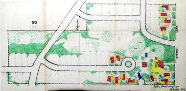
Work on paper - Architectural drawings, Colour plan of Lum road estate, 1970-1986
This plan of Lum Road Estate includes layout of roads, gardens, building and carparks. From 1970 until August 1971 Robin Boyd and his practice Romberg & Boyd Architects worked on designs for housing on the Lum Road Estate, Wheelers Hill. Berenice Harris, Linley Vellacott and Karl Fender drew many of the sketch plans for the project homes, while Robin Boyd drew the perspectives. This colour plan of the estate was drawn by Robin Boyd, but not signed. Frederick Romberg later annotated the drawing with details of its authorship. Colour plan of Lum road estate. Includes layout of roads, gardens, buildings and flora.Inscribed lower right on recto in black ink, 'Robin Boyd original / 12/6/86 F.R' ; Inscriber upper left on recto, grey pencil, '3400'.architecture, design, rmit design archives, domestic architecture -
 Ballarat Tramway Museum
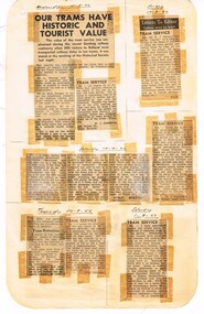
Newspaper, State Electricity Commission of Victoria (SEC) and The Courier Ballarat, Our trams have historic tourist value, Aug. 1962
Yields information about the view of The Courier, and locals about the mooted closure of the tramway system.Foolscap sheet of plain paper, with rounded corners, with 8 newspaper cuttings, concerning the mooted closure of the Ballarat Tram system August and September. 1962. All from The Courier. 1 - "Our trams have historic and tourist value" - recent ARHS visit and San Francisco 2 - W. Parsons - travelling on rough trams compared to buses 3 - SAH - response to above letter - limited buses in Norman estate and church services 4 - Public Spirited - tram services in general 5 - W. Parsons - supporting buses 6 - Old Digger - response to above 7 - W. Parsons - ditto - getting off track! closure, letter to the editor, editorial, sec -
 Ballarat Tramway Museum
Photograph - Digital image Set of 7, Chris Phillips, early 1960's
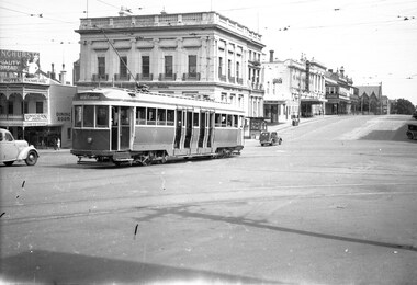
Yields information about tramway operations in Sturt St c1970.Set of 7 digital images of trams in Sturt St, c1970 - Photos by Chris Phillips. .1 - No. 26, in bound near Armstrong St - destination of Mt Pleasant St. Has the Commercial Bank of Australia building in the background - CBC .2 - No. 26 in bound to City, near Hospital Corner. .3 - No. 17 near the Doveton St intersection, has a roof advert "Make Bliss Not Love". Has the State Savings Bank, CAGA Finance, CBC bank buildings in the background. .4 - No. 12 in bound with the destination of Gardens via Sturt St West, at the corner of Dawson and Sturt St. Shows the tram stop. Has the R. E. Hayden Real Estate building in the background. .5 - No. 39 inbound at Hospital corner. .6 - No. 39 at the City terminus with the Post Office in the background. .7 - No. 43 outbound to the Gardens Via Sturt St west near Drummond St. Has the Marshall battery centre, Morris Ellis & Sons, Pope Mowers and The Ballarat Modern Diary in the background. Also a sign for AWA car radio.trams, tramways, sturt st, hospital corner, doveton st, dawson st, tram stops, tram 26, tram 17, tram 12, tram 39 -
 Ballarat Tramway Museum
Photograph - Black & White Photograph/s, Negative, Ellis Collection, c1950
Yields information about the appearance of Sturt St c1950 and the Lydiard St intersection.Black and white photograph of a single trucker west bound in Sturt St at Lydiard St North. Note the bus alongside the tram. Has the National Mutual building and Commonwealth Bank buildings. Sign on the National Mutual building advertising Commercial Union Insurance and Doepel and Lilley Real Estate. Bracket arms are of the type that required the pole to be cut into. c1950. Item donated comprised negative 1095, A4 print and laminated A4 print. Negative scanned at 2400dpi. On the top edge of one of the prints "same as 1094"trams, tramways, ballarat, sturt st, secv, lydiard st, tram 30 -
 Ballarat Tramway Museum
Negative, Wal Jack, 16/12/1945 12:00:00 AM
Yields information about the appearance of the ex Melbourne bogie trams, in the interim before the renumbering of the tram was completed.Negative and Digital image of the Wal Jack Ballarat Negative file of at new bogie tram to Ballarat, turning from Lydiard St North into Sturt St, with the destination of Gardens via Drummond North. Most likely No. 22, based on Reg Item 5273 - 16/12/1945 Has the Commonwealth Bank, Beacham's Unicorn Hotel, A. J. Rowland Estate Agent, Hagers Cafe?, Her Majesty's Theatre, The Ballarat Wattle, the newsagent kiosk and at the time, the Methodist Church of Ballarat. trams, tramways, lydiard st, sturt st, new tramcars, bogie trams, tram 22 -
 Ballarat Tramway Museum
Newspaper, The Age, "Ballarat Tram Depot Sale", 17/06/1972 12:00:00 AM
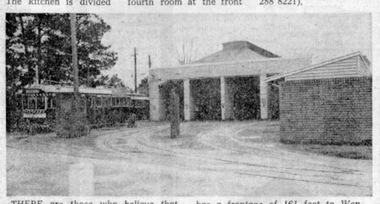
Yields information about the nature of the day/s towards the last full day of operation - at the tram depot. Used in the Courier Supplement to mark the closure of the system and how the Courier photo was used by another newspaper for another purpose.Newspaper clipping from The Age, Melbourne, 17/6/1972 editorial in the real estate section, p31, reporting the proposed sale of Wendouree Parade tram depot. To be offered at auction today at 10.30am, gives dimensions of block and auctioneers, Edgar Bartrop Pty Ltd. with photo of the depot from the street. For original of Photograph see Reg. item 3773. Also used in the Courier Supplement following the closure of the tramway.trams, tramways, depot, depot sale, ballarat, tram depot -
 Ballarat Tramway Museum
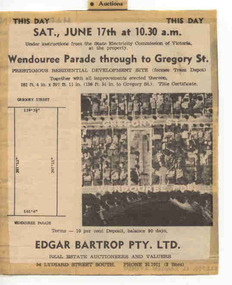
Newspaper, The Courier Ballarat, This Day Auction Notice, 17/06/1972 12:00:00 AM
Newspaper clipping from The Courier, Ballarat, dated Saturday, 17 June 1972 real estate advertisement, This Day Auction Notice, advising that the former SEC depot in Wendouree Parade is to be sold at 10.30am. Agent - Edgar Bartrop. Features an aerial photograph with the site and streets marked on it, along with the dimensions of the land to be sold. One of a large group of newspaper cuttings from John Bainbridge, 7/4/02. See Reg Item 2770 for Bartrop's handout.depot, buildings, auctions, bartrop -
 Ballarat Tramway Museum
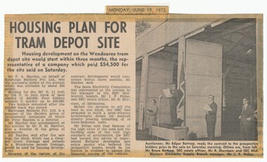
Newspaper, The Courier Ballarat, "Housing plan for tram depot site", 19/06/1972 12:00:00 AM
Newspaper clipping from The Courier, Ballarat, dated Monday, June 19, 1972 titled "Housing plan for tram depot site". Reports on the sale of the former tram depot on Saturday June 17 for $54,500. The purchaser expected to start development of housing on the site within three months. Reports on the sale, purchaser and SEC's views. Features a photo of Edgar Bartrop reading the contract. Others in the photo are Bruce Bartrop, SEC Estate officer, Mr. R. Morrison and SEC Manager Mr. I. F. Pellas. One of a large group of newspaper cuttings from John Bainbridge, 7/4/02.depot, buildings, auctions, bartrop -
 Ballarat Tramway Museum
Ephemera - MMTB Special Table, Melbourne and Metropolitan Tramways Board (MMTB), Dec. 1974
Has a strong association with a BTPS organised tour and yields information about the tour arrangements., Has a strong association with a BTPS organised tour and yields information about the tour arrangements.Spirit duplicated, handwritten Special Table" or timetable for a BTPS charter tram tour using two separate sheets of paper. Issued by the MMTB for a BTPS special charter on 16/12/1974. Inspector Davies, out of South Melbourne Depot. Gives time and route arrangements. Second copy from donation of the Tom Murray Estate added 20-11-2016.trams, tramways, btps, charters, special trams -
 Ballarat Tramway Museum
Ephemera - MMTB Special Table, Melbourne and Metropolitan Tramways Board (MMTB), Dec. 1975
Has a strong association with a BTPS organised tour and yields information about the tour arrangements., Has a strong association with a BTPS organised tour and yields information about the tour arrangements.Spirit duplicated, handwritten Special Table" or timetable for a charter tram tour. Issued by the MMTB for a BTPS special charter on 4/12/1975, Driver volunteer, Mr. Winspur, out of Hawthorn Depot. Gives time and route arrangements. Second copy from donation of the Tom Murray Estate added 20-11-2016.trams, tramways, btps, charters, special trams -
 Ballarat Tramway Museum
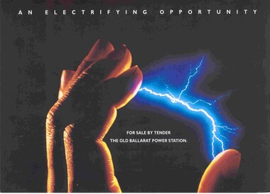
Pamphlet, Jones Lang Wootton and Jens Gaunt, "An Electrifying Opportunity", Apr. 1993
Real Estate advertising, marketing brochure or pamphlet, 240g stock, four colour, laminated after printing for the sale by tender of the former SEC Ballarat A power station, corner Ripon and Wendouree Parade, Ballarat. Agents Jens Gaunt, and Jones Lang Wootton. Has on the rear of the brochure an aerial photo. showing the location, location map and a short marketing statement. Three copies held. Two additional copies added 19/05/2006. See Reg Item 2783 for the contract of sale document.trams, tramways, power station, wendouree parade, sec, ballarat a power station -
 Ballarat Tramway Museum
Slide - 35mm slide/s, Travis Jeffrey, c1962
Agfa plastic mount (blue base, white cover) with a photo of Bendigo 29 at the North Bendigo terminus. Photo taken from the level crossing, looking across to the new housing estate, then under construction. Tram has the destination of Golden Square and has a SEC Briquettes roof advertisement."BES 14" in penciltramways, trams, bendigo, north bendigo, tram 29 -
 Ballarat Tramway Museum
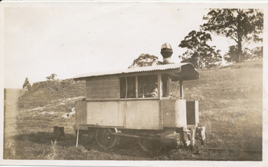
Photograph - Former Bendigo Steam motors at David Mitchell Estate, Ray Pearson, c1930
Two black and white photographs of former Bendigo steam motor No. 2 at the David Mitchell estate railway, Lilydale district, photographed c1930. Reference Light railways 208, August 2009, page 9.Yields information about a former Bendigo steam motor.Black and White copy print contained within the Wal Jack Bendigo and Geelong Album, see Reg Item 5003 for more details. .1 - On rear in ink "Steam motor from the Bendigo steam tramway's (rebuilt). This was taken at the David Mitchell Estate at Lilydale used to run to the Mt Evelyn about 6 miles. Broken up after this photo was taken" Similar notes on rear of Ken Magor collections with the additional detail of photographer - Ray Pearson.trams, tramways, bendigo, steam trams, light railways, tram 2 -
 Ballarat Tramway Museum
Album - Photo Album, c1970
Set of 16 photos of Ballarat tram system taken 1970c on a tour by an unknown Qld based person.Photo album containing 16 colour prints. Photo album has heavy card covers, covered in black textured plastic containing 12 clear plastic photo sleeves held with a white comb binder. Photos of Ballarat prior to closure, c1970. Photographer unknown. Donated by Peter Hyde of Brisbane Tramway Museum to BTM 3/2/2010, from a deceased estate. Photos apparently taken on a tram tour. .1 - No. 42 and a single trucker inbound in Sturt St. .2 - taken from tram ascending Bakery St hill in Victoria St. .3 - End of No. 42, with the destination "Haddon St via Drummond Nth" .4 - No. 11 and 42 in Lydiard St Nth, near the railway station. No. 11 showing special. .5 - photo of three people on the tour. .6 - Trams reversing at the Victoria St terminus .7 - ditto .8 - 11, 42 and 12? in Lydiard St North by railway station. .9 - Three trams at Sebastopol terminus. .10 - View in Albert St Sebastopol looking north along the track on the side of the road. .11 - View of the tram crossing in Albert St. .12 - 27 and 42 crossing Albert St Sebastopol. .13 - View of Albert St from the tram, north of the crossing looking at the reserved track 14. - Lydiard St North looking south .15 - 42 at the railway level crossing. .16 - View south of the railway level crossing, three trams, with passengers alighting.trams, tramways, ballarat, albert st, sebastopol, victoria st, sturt st, lydiard st nth, railway crossing -
 Bendigo Historical Society Inc.
Document - R.S.L. BENDIGO COLLECTION: LIMIL
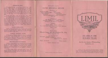
Pink pamphlet titled Limil Its Uses in the Building Trade And for the Garden, Whitewashing, Sanitation, etc. Detailed are the quantities to use and how to use it. There are several different mixes for Brickwork, Plastering and Concrete. Also mentioned are the uses and quantities for: Limil for Lawn & Garden, Limil for Whitewash, Poultry Insecticide, Outhouse Sanitation, Limewater for Internal Use, Preserving Eggs, Water Purification, Animals Drinking Water and Treating Sheep for Footrot. Manufacturer: David Mitchell Estate. Works are at Lilydale. Printed by Fraser & Jenkinson Pty Ltd,Fraser & Jenkinson Pty. Ltd., 341-5 Queen St., Melbourneephemera, mementoes, advertising, r.s.l. bendigo collection - limil, brickwork, plastering, concrete, limil for lawn & garden, limil for whitewash, poultry insecticide, outhouse sanitation, limewater for internal use, preserving eggs, water purification, animals' drinking water and treating sheep for footrot, david mitchell estate, fraser & jenkinson pty ltd -
 Bendigo Historical Society Inc.
Document - PETER ELLIS COLLECTION: LETTER, 4th October, 1976
Letter, dated 4/10/1976 from Diana R. Collier, Hon. Secretary, The Bendigo Field Naturalists Club to The Minister for Lands, The Hon. W. A. Borthwick making an application to have a reserved area for the preservation of native flora and fauna near the Quarry Hill Golf Club. Features, fauna and flora are mentioned including an original Boundary Stone and the Fairy Waxflower (Eriostemon verrucosus) also known as the Bendigo Wax Flower. Included is a list of birds (including some that nest in the area sometimes) and plants.communication, postal, letters, peter ellis collection, the bendigo field naturalists club, proposed boyd st nature reserve, the hon w a borthwick, recreation reserve extension (rs 3458), cemetry reserve extension (rs 3777), rubbish depot (rs 5980), education purposes reserve, (rs 6402), j willis, bendigo city council, city boundary stone, regel, quarry hill golf club, canberra botanical gardens, stony ridge flora reserve sydney, kings park perth, maranoa gardens melbourne, kaweka sanctuary castlemaine, central and northern branch of the national trust, school sanctuary (quarry hill), education dept, society for growing australian plants - bendigo group, lawn cemetery, bendigo city council parks and recreation dept, bendigo trust afforestation committee, quality of life action group, ackhurst plan, winifred waddell estate, dept of crown lands and survey, ministry for conservation, mr g edwards, mr m goode, mr j chellacombe, diana r collier -
 Bendigo Historical Society Inc.
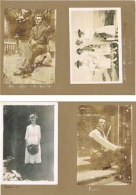
Photograph - HILDA HILL COLLECTION: BLACK AND WHITE PHOTOS, 1921
Hilda Hill Collection. Black and White Photos Total of 7 in subset, 3 containing images of Victorian Coastline in particular Pt Lonsdale and Queenscliff in 1921. Another has a family group on a property owned in Kyneton Victoria known as 'Durvol' in October 1920. Ken wearing a grey suit and sitting on a large stone in the garden stargazing, to his left is a short section of a picket fence and ornate corner post, large trees in the background. Four ladies standing on the rock as the seaside, Doreen, Nora, Lila, and Rita, all dressed in white, the second and third are carrying darker coloured coats on their arms, Queenscliff 1921.Leonie dressed in white and holding a black hat with both hands, background shows trellis and weather boards, left foreground may be heap of cut wood. Frank is sitting on steps dressed in white shirt, dark waistcoat, and dark trousers, background is brick wall and handrail attached to the steps. Four ladies in four wheel tourist coach owned by J. L. Priddle, the two at the front are both wearing white, lady to the left also is wearing a dark coat and scarf, the ladies at the rear are both wearing dark tops and the lady on the outer is wearing a white dress. The background appears to be covered on shrubbery. Four ladies sitting on the rocks at Queenscliff February 1921, Three of the ladies are dressed in white, one in a darker colour, all are wearing hats of similar design either black or white. Pone man dressed in a black suit with a white shirt and black tie, the three ladies are all wearing white blouses and darker dresses, the child at the front is dressed entirely in white, Merry??? Durvol October 1920.Hilda Hill Persdonal Collectionaustralia, history, port londsdale & queenscliff, hilda hill ? realted to frank a hill, stock and station agent and hill family real estate. family owned property out at eppalock. could this be where 'the ranch' property was located? -
 Bendigo Historical Society Inc.
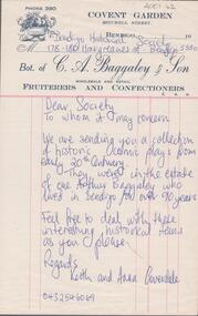
Letter - Invoice
Arthur Baggaley, Fruiterer, lived at 15 Forest Street, Bendigo. His business 'C.A. Baggaley & Son' was at Covent Garden, Mitchell Street, Bendigo. Arthur was born in Bendigo in 1903 to Charles Arthur Baggaley and Ada (Mallon). He married Evelyn May Grigg. Arthur died in September, 1993.C.A. Baggaley & Son invoice. On top of invoice: 'Phone 390, Covent Garden, Mitchell Street, Bendigo. Bot. of C.A. Baggaley & Son, Wholesale and Retail, Fruiterers and Confectioners' Baggaley CollectionWritten on invoice in blue biro: 'Bendigo Historical Society, 178-180 Hargreaves St. Bendigo, 3550. Dear Society, to whom it may concern. We are sending you a collection of historic comic plays from early 20th Century. They were in the estate of one Arthur Baggaley who lived in Bendigo for over 90 years. Feel free to deal with these interesting historical items as you please. Regards, Keith and Anna Coverdale'. fruiterer, confectioner, business, mitchell street, covent garden, coverdale -
 Ballarat Tramway Museum
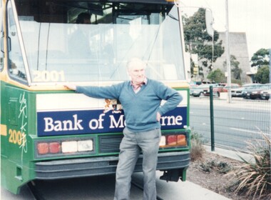
Photograph - Ian Stanley and tram 2001, Kathy Stanley, 26-7-1997
Photo shows BTM Member and tramway enthusiast Ian Stanley with B1 2001 at the East Burwood terminus during an ARHS tram tour. Tram has a Bank of Melbourne advertisement on the front.Yields information about Ian Stanley whose estate donated considerable material to the Museum.Colour print on Agfa paper of Ian Stanley at East Burwood terminus leaning on tram B1 2001 - 26-7-1997Has details of the location and dates on rear along with photographers number.tramways, tramcars, east burwood, b1 class, tram 2001 -
 Ballarat Tramway Museum
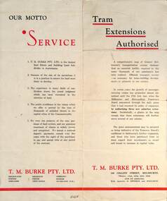
Pamphlet - Real Estate, T M Burke Pty Ltd, "Tram Extensions Authorised", 1936
Wal Jack collected tramway and railway items for his collection. This pamphlet gives details of the Melbourne Public Transport system - rail, tram and bus in late 1936. Issued by T M Burke Pty Ltd of 840 Collins St Melbourne, Real Estate agents, shows the extensive sub-divisions where land was available for purchase and notes the MMTB authorisation of new tram routes. Gives details of the T M Burke services. Routes shown as authorised (16-7-1936) are: Keilor Road Essendon, High St North Balwyn and Hawthorn Road East Brighton. Demonstrates a Real Estate Sales pamphlet.Pamphlet - four colours printed on cream coloured bond paper, folded vertically originally.letter, wal jack, buninyong, railway lines -
 Kew Historical Society Inc
Plan, Melbourne and Metropolitan Board of Works, Borough of Kew : Detail Plan No.1580, 1904
The Melbourne and Metropolitan Board of Works (MMBW) plans were produced from the 1890s to the 1950s. They were crucial to the design and development of Melbourne's sewerage and drainage system. The plans, at a scale of 40 feet to 1 inch (1:480), provide a detailed historical record of Melbourne streetscapes and environmental features. Each plan covers one or two street blocks (roughly six streets), showing details of buildings, including garden layouts and ownership boundaries, and features such as laneways, drains, bridges, parks, municipal boundaries and other prominent landmarks as they existed at the time each plan was produced. (Source: State Library of Victoria)This plan forms part of a large group of MMBW plans and maps that was donated to the Society by the Mr Poulter, City Engineer of the City of Kew in 1989. Within this collection, thirty-five hand-coloured plans, backed with linen, are of statewide significance as they include annotations that provide details of construction materials used in buildings in the first decade of the 20th century as well as additional information about land ownership and usage. The copies in the Public Record Office Victoria and the State Library of Victoria are monochrome versions which do not denote building materials so that the maps in this collection are invaluable and unique tools for researchers and heritage consultants. A number of the plans are not held in the collection of the State Library of Victoria so they have the additional attribute of rarity.Original survey plan, issued by the MMBW to a contractor with responsibility for constructing sewers in the area identified on the plan within the Borough of Kew. The plan was at some stage hand-coloured, possibly by the contractor, but more likely by officers working in the Engineering Department of the Borough and later Town, then City of Kew. The hand-coloured sections of buildings on the plan were used to denote masonry or brick constructions (pink), weatherboard constructions (yellow), and public buildings (grey). The area represented in this detail plan has undergone significant change during the 20th century. The widening of High Street in the 1930s and 1950s involved the shops on the south side of High Street being demolished and later rebuilt to fit the widened street. Another significant loss was the mansion ‘Drayton’ fronting Wellington Street, owned at this stage by Susannah Fenton. Her family name would later to be given to Fenton Way, which was to be built over the grounds of the house following its demolition. The plan of the garden is particularly interesting, containing a batten dome fronting Wellington Street, an ornamental pond, a fountain and a brick and glass conservatory. The notes by the plumbing contractor on this plan are particularly detailed. Pink borders delineate the ownership of the varying parcels of land. Some of the better known owners listed include the real estate agent Cr. Henry de Castres Kellett (bt) and John Padbury, the funeral director. This particular plan provides a clear view of the configuration of the Kew Junction in 1903 and the commercial buildings that surrounded it.melbourne and metropolitan board of works, detail plans, maps - borough of kew, mmbw 1580, cartography -
 Kew Historical Society Inc
Plan - Subdivision Plan, H C Crouch, Old Golf Links Estate, 1930s
The land in North Kew between the Outer Circle Railway and the River Yarra was released in sections. This release included 80 lots. Most of this area was released during the Depression years in the early 1930s.Subdivision plans are historically important documents used as evidence of the growth of suburbs in Australia. They frequently provide information about when the land was sold on which a built structure was subsequently constructed as well as evidence relating to surveyors and real estate and financial agents. The numerous subdivision plans in the Kew Historical Society's collection represent working documents, ranging from the initial sketches made in planning a subdivision to printed plans on which auctioneers or agents listed the prices for which individual lots were sold. In a number of cases, the reverse of a subdivision plan in the collection includes a photograph of a house that was also for sale by the agent. These photographs provide significant heritage information relating house design and decoration, fencing and household gardens.One part of a massive subdivision of the Old Golf Links Estate in North Kew of 80 allotments bordering Sutherland Avenue, Ramsay Avenue, Belford Road, Beresford Street and Coleman Avenue. Inset on the plan at the top left, the route of the Outer Circle Railway is clearly marked. The Kew Golf Links is identified in its current location. The land on which Greenacres Golf Club was to be constructed is at this time marked as ‘Recreation Ground’. The ‘new bridge’ over the Yarra at Burke Road is also marked on the inset map. The Plan identifies the surveyor (sic) H.C. Crouch BCE MVIS, 443 Little Collins St., Melbourne. The date of the subdivision auction sale in identified as Saturday September 25th at three o'clock.Annotations: "E" top left. "Golf Links" top right. Lots 73-76 ticked and listed as "6" poundssubdivisions -- kew (vic.), old golf links estate -
 Kew Historical Society Inc
Photograph - Cosy Five Roomed Rough Cast Bungalow, Kew, J E Barnes, c.1920
Subdivision plans are historically important documents used as evidence of the growth of suburbs in Australia. They frequently provide information about when the land was sold on which a built structure was subsequently constructed as well as evidence relating to surveyors and real estate and financial agents. The numerous subdivision plans in the Kew Historical Society's collection represent working documents, ranging from the initial sketches made in planning a subdivision to printed plans on which auctioneers or agents listed the prices for which individual lots were sold. In a number of cases, the reverse of a subdivision plan in the collection includes a photograph of a house that was also for sale by the agent. These photographs provide significant heritage information relating house design and decoration, fencing and household gardens. The photograph is also aesthetically significant as it was taken by J. E. Barnes, a nationally significant photographer. He was the most important photographer to have worked in Kew. He was active as a photographer in the district from c.1906 until his death in 1921. Best known as 'the Embarkation Photographer' (see the Australian War Memorial collection), Josiah Earl Barnes was also the official photographer employed by the Borough (and later Town, then City) of Kew. He clearly also completed commercial jobs for local businesses, as is the case in this photograph of a house for a local real estate and financial agent. A modest weatherboard house with rough-cast rendered walls. The gabled entrance incorporates elements of the Japanese aesthetic. The strong lines of the dark timber gable are reinforced by the colour and shape of the pickets in the fence. In contrast to an earlier period, the chimneys appear truncated. The use of extensive double-hung sash windows in the front rooms reflects a new interest in light in houses. The use of separate sunshades over windows in an earlier period is here replaced by an extension of the roofline over the window. The photographer Josiah Barnes died in 1921; so, the photograph of the house must predate this date. The location of the house, which was advertised for sale, has to date not been identified. Illegible inscription. Photographer's information on mount.josiah earl barnes, j e barnes, photography - kew, interwar housing - victoria, 1920s housing - kew -
 Kew Historical Society Inc
Photograph - 2 Young Street, Kew, Paramount Photos, 1920s
... and household gardens. real estate photographs 2 young street - kew ...Subdivision plans are historically important documents used as evidence of the growth of suburbs in Australia. They frequently provide information about when the land was sold on which a built structure was subsequently constructed as well as evidence relating to surveyors and real estate and financial agents. The numerous subdivision plans in the Kew Historical Society's collection represent working documents, ranging from the initial sketches made in planning a subdivision to printed plans on which auctioneers or agents listed the prices for which individual lots were sold. In a number of cases, the reverse of a subdivision plan in the collection includes a photograph of a house that was also for sale by the agent. These photographs provide significant heritage information relating house design and decoration, fencing and household gardens.A prepossessing, large home constructed in the Arts and Crafts style. Located on the banks of the Yarra at 2 Young Street, Kew overlooking the factories of Richmond, the design of the house takes account of the gradient with the addition of a level below the front entrance. The elegant roof includes a number of projecting gables and dormers. The gables are typically half-timbered and rendered. In addition to the asymmetrically placed portico, there are at least two open verandas, supported by timber pillars and with roofs that reflect the overall pitch of the roof of the housereal estate photographs, 2 young street - kew -
 Kew Historical Society Inc
Photograph - 29 Uvadale Grove, Kew, 1920
The numerous subdivision plans in the Kew Historical Society's collection represent working documents, ranging from the initial sketches made in planning a subdivision to printed plans on which auctioneers or agents listed the prices for which individual lots were sold. In a number of cases, the reverse of a subdivision plan in the collection includes a photograph of a house that was also for sale by the agent. Subdivision plans are historically important documents used as evidence of the growth of suburbs in Australia. They frequently provide information about when the land was sold on which a built structure was subsequently constructed as well as evidence relating to surveyors and real estate and financial agents. These photographs provide significant heritage information relating house design and decoration, fencing and household gardens.When 29 Uvadale Grove, Kew was offered for sale it was described as: ‘Kew. Fine locality, 3 minutes Cotham Road. Splendidly built 6 roomed Brick Villa. Rooms 17 x 14, 16 x 13, &c. Beautifully fitted throughout. Land 70 x 134 to ROW.’ The price was advertised as being £1,400. The house exhibits key features of Federation architecture such as the gabled roof with a facing of half-timber and stucco. The veranda has a curved corrugated iron roof supported by timber pillars and fretwork. The slate roof with terra cotta ridging and finials marks a transition to the more common use of Marseilles tiles in Federation architecture.subdivisions - kew (vic.), 29 uvadale grove - kew (vic.) -
 Kew Historical Society Inc
Photograph - 'Mount Eri', 9 Highbury Grove, 1919
Subdivision plans are historically important documents used as evidence of the growth of suburbs in Australia. They frequently provide information about when the land was sold on which a built structure was subsequently constructed as well as evidence relating to surveyors and real estate and financial agents. The numerous subdivision plans in the Kew Historical Society's collection represent working documents, ranging from the initial sketches made in planning a subdivision to printed plans on which auctioneers or agents listed the prices for which individual lots were sold. In a number of cases, the reverse of a subdivision plan in the collection includes a photograph of a house that was also for sale by the agent. These photographs provide significant heritage information relating house design and decoration, fencing and household gardens.A photograph of Mount Eri, 9 Highbury Grove, an 11-room house for sale near the junction of Cotham and Glenferrie Roads. The substantial red brick, slate-roofed house and its location are not identified in the photograph, although the extent of the house is noted. It was described then as ‘well situated’ and close to 3 trams. Mathers, a financial agent in Cotham Road, placed advertisements about the sale of the property in The Argus in May and June 1919. The advertisement additionally refers to a billiard room and asserts that the house has every modern convenience. An annotation on the plan indicates that the house, with tennis court, was sold for £1960. Following extensive research, the house has now been conclusively identified, albeit extended and rendered. The house was originally built in the 19th century as a school and for much of the 20th century was used as a venue for receptions. -
 Kew Historical Society Inc
Photograph - Victorian Villa, High Street, c.1922
Subdivision plans are historically important documents used as evidence of the growth of suburbs in Australia. They frequently provide information about when the land was sold on which a built structure was subsequently constructed as well as evidence relating to surveyors and real estate and financial agents. The numerous subdivision plans in the Kew Historical Society's collection represent working documents, ranging from the initial sketches made in planning a subdivision to printed plans on which auctioneers or agents listed the prices for which individual lots were sold. In a number of cases, the reverse of a subdivision plan in the collection includes a photograph of a house that was also for sale by the agent. These photographs provide significant heritage information relating house design and decoration, fencing and household gardens.An old inscription on this photograph identifies it as ‘an elegant timber villa in High Street. It occupied part of Lot 91, bought by Edward Glyn in the land sale of 16th October 1851, and run as a flower farm’. The subdivision called the ‘Flower Farm Estate’ in East Kew occurred in 1922. [The subdivision plan is on the reverse of this photo.] The Estate included 61 lots on either side of Boorool Road between High Street and Harp Road. In the MMBW Detail Plan 2017 of 1926, a number of these new villas had already been built. Matching houses with MMBW maps can always be a challenge, however if this house was near the corner of Boorool Road and High Street, it seems to fit the profile of a house called ‘Maxton’ (demolished).Photographer's name on photograph, lower right, and stamp on mount lower right: "A. Aberline, Glenferrie".houses - maxton - high street - kew (vic.), violet farm estate, subdivisions - kew (vic.) -
 Kew Historical Society Inc
Photograph - 8 roomed DF Brick Villa, Kew, J E Barnes, c.1920
Subdivision plans are historically important documents used as evidence of the growth of suburbs in Australia. They frequently provide information about when the land was sold on which a built structure was subsequently constructed as well as evidence relating to surveyors and real estate and financial agents. The numerous subdivision plans in the Kew Historical Society's collection represent working documents, ranging from the initial sketches made in planning a subdivision to printed plans on which auctioneers or agents listed the prices for which individual lots were sold. In a number of cases, the reverse of a subdivision plan in the collection includes a photograph of a house that was also for sale by the agent. These photographs provide significant heritage information relating house design and decoration, fencing and household gardens. The photograph is of additional aesthetic significance as it was photographed by J. E. Barnes. Josiah Earl Barnes is a nationally significant photographer. He was also the most important photographer to have worked in Kew. He was active as a photographer in the district from c.1906 until his death in 1921. Best known as 'the Embarkation Photographer' (see the Australian War Memorial collection), J. Earl Barnes was also the official photographer employed by the Borough (and later Town, then City) of Kew. He clearly also completed commercial jobs for local businesses, as is the case in this photograph of a house for a local real estate and financial agent.A photograph, mounted on board of a double fronted Federation-era brick villa in Kew, photographed for a local real estate agent and financier by J. E. Barnes of Kew. On the reverse of the photograph is a subdivision plan for the Normanby Estate, East Kew - 2016.0039.1. As can be seen from the image, there is a large tear on the surface of the photograph.The brown card on which the photograph is mounted includes the following handwritten description, which may aid the identification of the house: "Kew, 3 minutes from tram, 8 roomed DF Brick Villa, tile roof including two attics, sleepout, bathroom, heater, E Light, Entrance Hall, double doors, leadlights, laundry, garden, lawns, land 75 x 170, 1975 pounds". Also photographers inscription on mount, lower left: J. E. Barnes / Photo / Phone 1966 Haw. KEW.j. e. barnes, josiah earl barnes, j. earl banes - photographer, architecture - federation style, houses - kew, real estate photographs -
 Kew Historical Society Inc
Photograph - W.B. Villa, Kew, c.1919
... and household gardens. houses - kew real estate photographs Stamped ...The photograph offers significant information relating to late Victorian / Federation colour schemes and fencing.The block fronted villa has a corrugated iron roof and a flat projecting verandah, ornamented with a trellis design of timber. The front window features a timber shade, mounted on brackets. The treatment of the block-fronted panels shows that there is an attempt to highlight imitation quoining through use of a darker colour. The windows and door are also in this darker shade. The front fence and gate are made of wooden pickets. It is unlikely that the photograph was taken at the time of the villa's construction given the size of the shrub/tree in the front garden.Subdivision plans are historically important documents used as evidence of the growth of suburbs in Australia. They frequently provide information about when the land was sold on which a built structure was subsequently constructed as well as evidence relating to surveyors and real estate and financial agents. The numerous subdivision plans in the Kew Historical Society's collection represent working documents, ranging from the initial sketches made in planning a subdivision to printed plans on which auctioneers or agents listed the prices for which individual lots were sold. In a number of cases, the reverse of a subdivision plan in the collection includes a photograph of a house that was also for sale by the agent. These photographs provide significant heritage information relating house design and decoration, fencing and household gardens.A real estate photograph, mounted on brown card, showing a double fronted weatherboard villa, located in Kew, Victoria. On the reverse of the photograph is a subdivision plan for the Altyre Estate.Stamped on mount: Top - "KEW. Close tram. Fine View. / W.B. Villa Containing 8 Rooms. / Up-to-date Conveniences. EL Etc." Below - "Land 40 x 165. 615 pounds. Sold"houses - kew, real estate photographs -
 Kew Historical Society Inc
Photograph - Double-fronted Edwardian Villa, c.1918
The Kew Historical Society's map collection includes a substantial number of real estate subdivision plans, mainly of Kew but also of surrounding suburbs in Melbourne. Most of the subdivision plans date from the 1920s and 1930s when the districts old homes and local farmland were being split up to accommodate residential growth in the postwar period. These early plans were assembled by a local firm, Jas R Mather & McMillan, which had an office in Cotham Road. Many of the plans, and sometimes photos, were annotated by the agents.Subdivision plans are historically important documents used as evidence for the growth of suburbs in Australia. They frequently provide information about when the land was sold as well as evidence relating to surveyors and real estate and financial agents. The numerous subdivision plans in the Kew Historical Society's collection represent working documents, ranging from the initial sketches made in planning a subdivision to printed plans on which auctioneers or agents listed the prices for which individual lots were sold. In a number of cases, the reverse of a subdivision plan in the collection includes a photograph of a house that was also for sale by the agent. These photographs provide significant heritage information relating house design and decoration, fencing and household gardens.The photograph may also be aesthetically significant depending on the importance of the photographic atelier.On the reverse of a subdivision plan of the Palmyra Estate (Kew) is a photograph of a double-fronted Edwardian villa. The weatherboard and stucco house with high brick chimneys provides a clear indication of the style of curtains and gardens in houses of the period. Holland blinds with lace inserts are used in the left front window. They are combined with long lace curtains. The garden, with its curved pathway is bordered with garden beds that include marguerite daisies and roses. Reflecting a new interest in the Australian landscape, tree ferns and ground ferns are planted closer to the house.houses - kew, architecture - edwardian, real estate photographs