Showing 395 items
matching mining lease
-
 Bendigo Historical Society Inc.
Document - MCCOLL, RANKIN AND STANISTREET COLLECTION: INDENTURE BETWEEN KING EDWARD VIII AND MONUMENT HILL CONSOLIDATED MINE, 2/09/1936
... shows lease 10878 in the Mining District of Bendigo, Parish... and offices to be used in connexion with 'mining purposes' ' Document ...Indenture document number 10878, Vol 317 Folio 35044. Foolscap 4 pages including a map, dated 2nd September, 1936, between King Edward VIII (Crown land) and Monument Hill Consolidated (Bendigo) No Liability 'carrying on operations in the Parish of Sandhurst, to occupy and use the land demised as a site for machinery buildings and offices to be used in connexion with 'mining purposes' ' Document signed by Right Hon William Charles Arcedeckne, (Baron Huntingfield) and J. Stanistreet, Manager, affixed with the Common Seal of Monument Hill Consolidated (Bendigo) No Liability. Map drawn on dark buff paper, and fixed to document. Map shows lease 10878 in the Mining District of Bendigo, Parish of Sandhurst, County of Bendigo. N.Area 2.2.24 ( 2 acres, 2 roods, 24 perches ) Lease site on Rowan Street, bordered by Ophir Street. Coloured in purple on plan with small red area. On bottom: ' Note Red Areas Excised. Scale 4 chains to 1 inch, M.M. Var. 8 degrees 32' E. On lease site, New Chum Gully marked, W.B. House, and Permanent Occy. marked on red area. On last page ownership of lease details from 1937 to 1942.bendigo, mining, monument hill consolidated, common seal of monument hill consolidated, nell gwynne mine, south nell gwynne gold mining company, bendigo mine, ophir street, rowan street, mackenzie street.indenture vol 317 fol. 35044. j stanistreet. -
 Bendigo Historical Society Inc.
Document - MCCOLL, RANKIN AND STANISTREET COLLECTION: LETTER RE LEASE 10931, 23rd January, 1942
2 page letter from Bendigo Mines No Liability, 360 Collins Street, Melbourne to Manager, Central Nell Gwynne Gold Mining Co., N.L., dated 23rd January 1942. Letter deals with the sale from Nell Gwynne Mines, to Central Nell Gwynne Company G.M.L., No. 10931. 'located within the boundaries of this lease was the main shaft of Nell Gwynne (B.M.L. ) Mines N.L. 'previous to this sale the leases held by the Nell Gwynne company had been consolidated into G.M.L. 10931 but a machinery area No 10878 also held by the Company covering the area around the main shaft to a depth of 25ft was not included in the consolidation owing to some technical objection by the Mines Department'bendigo, mining, bendigo mines no liability -
 Bendigo Historical Society Inc.
Document - MCCOLL, RANKIN AND STANISTREET COLLECTION: MAP OF MINE LEASES SYMONDS STREET, MCKENZIE ST WEST AREA BENDIGO, 2nd September, 1936
Blue waxed linen paper map. On top' Mining District of Bendigo' Parish of Sandhurst, County of Bendigo' Map shows lease 10135, area 32.1.19; lease 10371, area 30.0.23; lease 10179 area 41.3.4; lease 10370, area 49.0.1. Map indicates gully leading into and State Rivers and Water supply reservoir, water race; siphon, shaft, dam, residential area and some residential lots marked. Streets include Holly Street, MacKenzie Street West, Symonds Street, Aspinall Street, Emmett Street; Bendigo Creek marked at bottom of map. Scale 4 chains to one inch. Map is not dated.bendigo, mining, mccoll rankin & stanistreet -
 Bendigo Historical Society Inc.
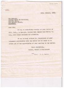
Document - MCCOLL, RANKIN AND STANISTREET COLLECTION: LETTER RE LEASE CENTRAL NEL GWYNNE, 24th January 1942
Copy of letter to The Manager, Bendigo Mines No Liability, 360 Collins Street, Melbourne. re lease for Central Nell Gwynne Gold Mining Co. Letter dated 24th January 1942, signed R.A. Rankin for McColl,Rankin & Stanistreet.bendigo, mining, central nell gwynne gold mining co -
 Bendigo Historical Society Inc.
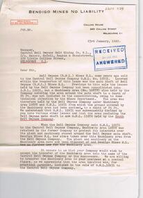
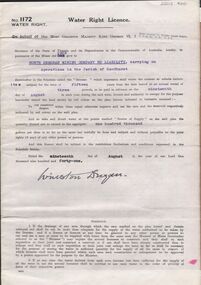
Document - MCCOLL, RANKIN AND STANISTREET COLLECTION: WATER RIGHT LICENCE NORTH DEBORAH MINING COMPANY NO LIABILITY, 19th August, 1941
4 page document plus map, Water Right Licence No. 1172, between King George VI ( the Crown ) and North Deborah Mining Company No Liability, Parish of Sandhurst., dated 19th August 1941. "to take and divert water at the points marked 'source of supply' on the said plan the quantity thereof not to exceed in the aggregate one hundred thousand gallons per diem' Plan: 'Mining District of Bendigo No. 1172 W.R., County of Bendigo, Parish of Sandhurst. Plan has dam area coloured in red, with pipe line drawn in red, leading from Battery marked on lease 11145 across lease 9988 to dam. Streets marked: Adams Road, Honeybone Street, Griston Street. (Golden Square area)bendigo, mining, north deborah mining company, north deborah mining company, adams, honeybone, and griston streets. (golden square)