Showing 10909 items matching " plans "
-
 Greensborough Historical Society
Poster - Planning Document, City of Heidelberg, Subdivision Plan # G 27, Greensborough and Diamond Creek, 1922 and 1963
Plan of Subdivisions in City of Heidelberg: Side 1: 2 plans, Parish of Keelbundoora: plan 1: Henry Street, Vermont Avenue, Lyell Street, Nell Street, McDowell Street, 1922. Plan 2: Henry Street, Nepean Street, Charles Street, 1922. Side 2: 2 plans Parish of Nillumbik, Portion 13: Plan 1: Diamond Creek Road, Delfin Crescent, Ridge Road, 1963. Plan 2: Kinglake Road, Eltham Road, 1963.An example of hard copy subdivision plans from the Greensborough area. Mainly from the Shire of Diamond Valley era (1964-1994).Plan (2 sided) mounted on heavy card. Contains 2 sheets pasted together.Stamped and handwritten Council permissions, dates and other details.subdivision plans, city of heidelberg -
 Canterbury History Group
Document - Plans of the proposed toilets at Canterbury Bowling Club, 1964
... Plans ...Plans of the proposed additional toilets at Canterbury Bowling Club roomscanterbury, canterbury bowling club, kendall street, plans, toilets, lawn bowls -
Clunes Museum
Plan - CLUNES TOWN HALL AND COURTHOUSE, 30TH JULY 1892
... PLANS ...MADE BY HARRY E SANDO CE; TOWN CLERK & ENGINEER, BOROUGH OF CLUNES, 30TH JULY 1892ACTUAL PLAN OF THE CLUNES TOWN HALL AND COURTHOUSE 1892 DRAWING DONE BY HARRY SANDS, TOWN CLERK AND ENGINEERlocal history, document, plans, town hall -
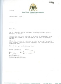 Greensborough Historical Society
Document - Correspondence and Minutes, Diamond Valley Choral Society, Shire of Diamond Valley Festival of Carols, performed by Diamond Valley Choral Society 1989, 10/12/1989
Planning documents relating to Shire of Diamond Valley Carols, December 1989. This performance is by the Diamond Valley Choral Society.Planning documents, letters and minutes.Some handwritten notes on minutes.diamond valley choral society, christmas music, diamond valley, carols -
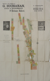 Federation University Historical Collection
Plan, G. Buchanan's Plan of the Berringa Gold Mines, 1866?
This plan is associated with former Ballarat School of Mines student Richard Squire (1875-1876) Gift of the Squire FamilyColoured plan of the Berringa Goldmines.squire, richard squire, berringa, g. buchanan, buchanan, stockbroker, birthday freehold, f. holst, holst, staffordshire reef, williams fancy, kangaroo, moonlight, cgt, staffordshire reef township, w. prie, northern birthday, a clinton, birthday star, a. lamb -
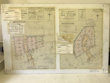 Greensborough Historical Society
Planning Document, John Taylor & Assoc, Subdivision Plan # 541, Somerleigh Crescent and Rainham Close, Greenhills, 21/06/1971
Plan of Subdivision at Somerleigh Crescent and Rainham Close, Greenhills.An example of hard copy subdivision plans from the Greensborough area. Mainly from the Shire of Diamond Valley era (1964-1994).Plan (2 sheets) mounted on heavy card.Stamped and handwritten Council permissions, dates and other details.subdivision plans, somerleigh crescent greensborough, rainham close greensborough -
 Greensborough Historical Society
Poster - Planning Document, City of Heidelberg, Subdivision Plan # G313, Corner Main and Grimshaw Streets, Greensborough, 08/03/1960
Plan of Subdivision at corner of Main and Grimshaw Streets, Greensborough.An example of hard copy subdivision plans from the Greensborough area. Mainly from the Shire of Diamond Valley era (1964-1994).Plan (2 sheets) mounted on heavy card.Stamped and handwritten Council permissions, dates and other details.subdivision plans, main street greensborough, grimshaw street greensborough -
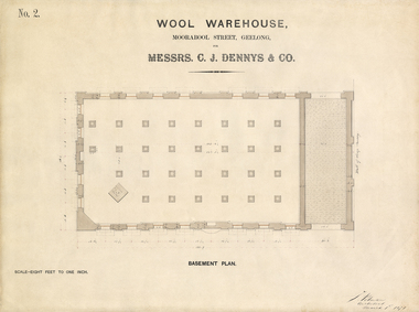 National Wool Museum
Architectural Plan, Wool Warehouse, Moorabool St, Geelong for Messrs C.J. Dennys & Co., Basement Plan No. 2
Original Jacob Pitman architectural plan of the Dennys Lascelles bluestone woolstore dated 1 March 1871 mounted in a wood frame under glass. Titled "Wool Warehouse, Moorabool St, Geelong for Messrs C.J. Dennys & Co., Basement Plan No. 2."Wool Warehouse, Moorabool St, Geelong for Messrs C.J. Dennys & Co., Basement Plan No. 2wool stores, pitman, mr jacob, dennys lascelles wool store -
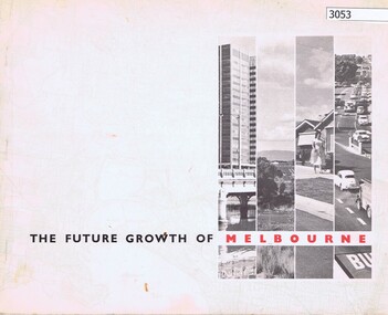 Greensborough Historical Society
Book, The Future growth of Melbourne, 1967_06
A report to the Minister for Local Government on Melbourne's future growth and its planning administration, June 1967.46 p., text and col. plansmelbourne (victoria), mmbw -
Clunes Museum
Document - PLAN OF MINE, RIP VAN WINKLE GOLD MINING CO, 1889
... PLANS ...After the demise of the Union Company, a third, short-lived period of deep lead mining commenced at Mount Greenock. This proved to be last mining in the area and was undertaken principally by two companies: the New Rip Van Winkle and Adam’s Freehold. These companies mined with some success through the 1880s. The Adams Freehold Company was the most preserving: it ended up sinking three shafts and operating for about ten years.PLAN OF RIP VAN WINKLE GOLD MINE COMPANY 1889 MINE ON NORTH SLOPE OF MOUNT GREENOCK VIA TALBOTEJ. SEMMENS CRESWICKlocal history, document, mining, plans -
Port Melbourne Historical & Preservation Society
Document - Letter re Planning Scheme amendment 476, Pat Grainger, c.1991
Four pages of nine written by Pat GRAINGER to the Minister for Planning, Jim KENNAN, regarding her objections to Planning Scheme Amendment 476, which was a part of the Bayside project . Typed foolscap of letter re Planning Scheme Amendment No. 476jim kennan, pat grainger, bayside project -
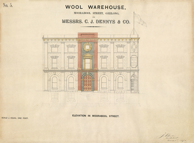 National Wool Museum
Architectural Plan, Wool Warehouse, Moorabool St, Geelong for Messrs C.J. Dennys & Co., Plan Elevation in Moorabool Street
Original Jacob Pitman architectural plan of the Dennys Lascelles bluestone woolstore dated 1 March 1871. Titled "Wool Warehouse, Moorabool St, Geelong for Messrs C.J. Dennys & Co., Plan Elevation in Moorabool Street".Wool Warehouse, Moorabool St, Geelong for Messrs C.J. Dennys & Co., Plan Elevation in Moorabool Streetwool stores, pitman, mr jacob, dennys lascelles wool store -
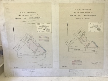
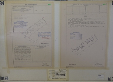 Greensborough Historical Society
Planning Document, Subdivision Plan #1034. 50 Hume Street, 03/02/1982
Plan of Strata Subdivision at 50 Hume Street Greensborough for 7 units.An example of hard copy subdivision plans from the Greensborough area. Mainly from the Shire of Diamond Valley era (1964-1994).Plan (2 sheets) mounted on heavy card.Stamped and handwritten Council permissions, dates and other details.subdivision plan -
 Greensborough Historical Society
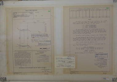
Planning Document, Subdivision Plan #1058. Wattle Drive Watsonia, 14/07/1983
Plan of Strata Subdivision at 6 Wattle Drive Watsonia for 6 units.An example of hard copy subdivision plans from the Greensborough area. Mainly from the Shire of Diamond Valley era (1964-1994).Plan (3 sheets) mounted on heavy card.Stamped and handwritten Council permissions, dates and other details.subdivision plans, wattle drive watsonia -
 Greensborough Historical Society
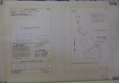
Planning Document, Subdivision Plan # 1060, 8 Ulmara Place Greensborough, 20/04/1983
Plan of Strata Subdivision at 8 Ulmara Place Greensborough for 2 houses.An example of hard copy subdivision plans from the Greensborough area. Mainly from the Shire of Diamond Valley era (1964-1994).Plan (3 sheets) mounted on heavy card.Stamped and handwritten Council permissions, dates and other details.subdivision plans, ulmara place -
 Greensborough Historical Society
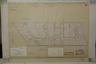
Planning document, Subdivision Plan #1009. Corner Allumba Drive and Beales Road Greensborough, 1981_
Plan of Subdivision of land at corner of Allumba Drive and Beales Road Greensborough.An example of hard copy subdivision plans from the Greensborough area. Mainly from the Shire of Diamond Valley era (1964-1994).Plan (2 sheets) mounted on heavy card.Stamped and handwritten Council permissions, dates and other details.subdivision plans, allumba drive, beales road -
 Greensborough Historical Society
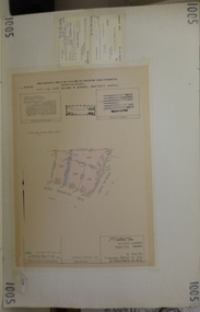
Planning document, Subdivision Plan #1005. Corner Douglas Court and Glen Katherine Drive Greensborough, 1981_
Plan of Subdivision. Corner Douglas Court and Glen Katherine Drive Greensborough.An example of hard copy subdivision plans from the Greensborough area. Mainly from the Shire of Diamond Valley era (1964-1994).Plan (2 sheets) mounted on heavy card.Stamped and handwritten Council permissions, dates and other details.subdivision plans, douglas court, glen katherine drive -
 Federation University Historical Collection
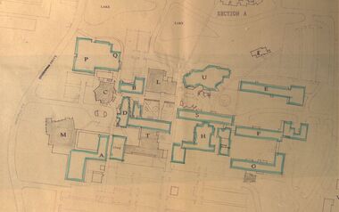
Plan - Site Plan, Mount Helen Campus Academic area
Federation University site plan made for the Ballarat College of Advanced Education Printed architectural plan of the Mount Helen campusprinted with location names and symbolssite plan, federation university, ballarat college of advanced education, mount helen campus, campus plan -
 Bendigo Historical Society Inc.
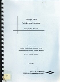
Book - BENDIGO 2020 SUB-REGIONAL STRATEGY, 1989
Bendigo 2020 Sub-Regional Strategy. Demographic Analysis.\ Prepared by Trevor Budge & Assoc for Bendigo Sub-Regional Committee of the Loddon-Campaspe Regional Planning Authority June 1989, 55 pagesTrevor Budge & Assoc for Bendigo Sub-Regional Committee of the Loddon-Campaspe Regional Planning Authoritybendigo, council, future direction & strategies. -
Federation University Historical Collection
Plan, SMB New Workshops, 1944
... plans ...Coloured ink on paper plan: Ballarat School of Mines New Workshops plans, smb workshops, percy everett, smb, ballarat school of mines, architectural plans -
 Bendigo Military Museum
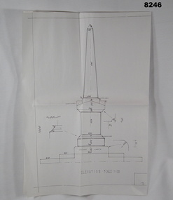
Plan - MONUMENT PLANS, C.1992
Plan for Monument in front of the Soldiers Memorial Institute Pall Mall Bendigo, refer Cat No 8245.2.Plan, white paper, all black ink of a proposed Monument, scale 1:100 showing front elevation, plan and section A.A"Proposed Monument to Ex Servicemen and Women to be erected in Pall Mall Bendigo"brsl, smirsl, monument, plan -
 Greensborough Historical Society
Poster - Planning Document, Shire of Diamond Valley et al, Subdivision Plan # 1044 - Parish of Nillumbik, County Bourke, Crown Allotment B Section 12, Eltham North, 1981-1987
Subdivision Plan # 1044 - Parish of Nillumbik, County Bourke, Crown Allotment B Section 12, Eltham North. This subdivision plan includes Weidlich Road and St Clems Street. The developer for this subdivision is Taunton Developments and the Surveyors are Fisher Cleeland Turner & Dwyer Vic, Surveyors and Engineers.An example of hard copy subdivision plans from the Greensborough area. Mainly from the Shire of Diamond Valley era (1964-1994).Plan (single sided) mounted on heavy card. Stamped and handwritten Council permissions, dates and other details. subdivision plans, shire of diamond valley, taunton developments -
Whitehorse Historical Society Inc.
Document, 762-764 Whitehorse Road Mitcham, 2012-13
Endorsed plans and amending plans for proposed development at 762-764 Whitehorse Road Mitcham .Endorsed plans and amending plans for proposed development at 762-764 Whitehorse Road Mitcham for a 4 storey building of 60 apartments, with VCAT hearing notes.Endorsed plans and amending plans for proposed development at 762-764 Whitehorse Road Mitcham .whitehorse road mitcham, no 762-764 -
Whitehorse Historical Society Inc.
Article, Bridge Plan under fire, 2016
Whitehorse Council has demanded a meeting with Planning Minister Richard Wynne.Whitehorse Council has demanded a meeting with Planning Minister Richard Wynne after he controversially approved Deakin University's plan for a bridge in a Burwood Park.Whitehorse Council has demanded a meeting with Planning Minister Richard Wynne. city of whitehorse, deakin university burwood campus, burke, anna, wynne, richard -
 Greensborough Historical Society
Planning Document, Subdivision Plan # 1016. Corner Weidlich and St Clems Roads Greensborough, 05/10/1981
Plan of Subdivision of land at corner of Weidlich Road and St Clems Road Greensborough.Plan (2 sheets) mounted on heavy card.Stamped and handwritten Council permissions, dates and other details.subdivision plans, weidlich road -
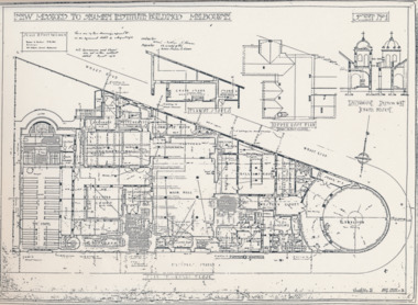 Mission to Seafarers Victoria
Plan - Architectural drawings, Walter Butler, New Missions to Seamen Institute Buildings Melbourne, 1916
In August 1916, Walter R. Butler presented the plans for the future central Seamen's Institute.The drawings show the original plans with rooms' names and intended use. They also show the original concept for the chapel which was in the Spanish Mission style.Plan copied from the 1983 Howden and Wardrop A4 report. A large plan on tracing paper (original or copy of the original) is held in the MSTV archives.flinders street, mission to seamen, mission to seafarers, walter richmond butler (1864–1949), norla dome, st peter chapel, spanish mission, arts and crafts, 1916 -
 Kew Historical Society Inc
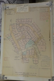
Plan - Subdivision Plan, Argyle Road, Heather Grove, Victor Avenue, Kew, c.1937
The Kew Historical Society's map collection includes a substantial number of real estate subdivision plans, mainly of Kew but also of surrounding suburbs in Melbourne. Most of the subdivision plans date from the 1920s and 1930s when the districts old homes and local farmland were being split up to accommodate residential growth in the postwar period. These early plans were assembled by a local firm, Jas R Mather & McMillan, which had an office in Cotham Road. Many of the plans, and sometimes photos, were annotated by the agents.Subdivision plans are historically important documents used as evidence for the growth of suburbs in Australia. They frequently provide information about when the land was sold as well as evidence relating to surveyors and real estate and financial agents. The numerous subdivision plans in the Kew Historical Society's collection represent working documents, ranging from the initial sketches made in planning a subdivision to printed plans on which auctioneers or agents listed the prices for which individual lots were sold. In a number of cases, the reverse of a subdivision plan in the collection includes a photograph of a house that was also for sale by the agent. These photographs provide significant heritage information relating house design and decoration, fencing and household gardens.The photograph may also be aesthetically significant depending on the importance of the photographic atelier.Undated blue subdivision plan in Kew of 14 lots facing Argyle Road, Heather Grove and Victor Road. The Plan identifies Tuxen & Miller as the surveyors. [Formerly catalogued as MAP.0059]subdivision plans - kew, argyle road - kew, heather grove - kew, victor avenue - kew -
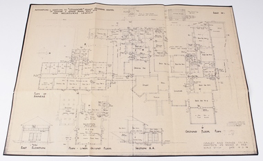 Melbourne Legacy
Work on paper - Document, plans, Alterations and additions to Stanhope Legacy Childrens' Hostel, Parts .2) and .3) 19.2.46. Parts .4) and .5) August 50
Detailed plans for the redevelopment of the Stanhope Childrens Hostel and Staff Accomodation.Melbourne Legacy established residences to aid children of deceased servicemen complete their education, take further education and find employmentEnvelope containing various Stanhope Residence plans and written history. 00042.1) beige coloured envelope with ’Stanhope Residence’ handwritten on front. 00042.2) Drawn plan ‘Alterations and Additions to Stanhope Legacy Childrens Hostel’ ‘Sheet No 1’ 00042.3) Drawn plan ‘Alterations and Additions to Stanhope Lecacy Childrens Hostel’ ‘Sheet No 2’ 00042.4) Drawn Plan ‘Staff Accomodation Stanhope’. 00042.5) ‘Plan of Drainage’ Stanhope. 00042.6) Short written account of Stanhope History 00042.7) Typed transcript of short written account of Stanhope history.residences, properties, stanhope -
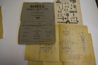 Warrnambool and District Historical Society Inc.
Documents, Atlas Automatic Fire Services Pty Ltd, Woollen Mill, late 20th century
These items are from the Warrnambool Woollen Mill and relate to the fire protection services operating at the factory in the late 20th century. The Warrnambool Woollen Mill was commenced as a local public company and opened in 1910 in South Warrnambool with the first manager, John Bennett. During World War Two there were 700 employees at the mill due to wartime demand. In 1958 the factory became the first in Australia to manufacture electric blankets. In 1968 the mill was purchased by the Dunlop company and in 1982 Dunlop sold out to Onkaparinga Woollen Company which was taken over by Macquarie Worsteds and became known as Warrnambool Textiles. When Macquarie Worsteds ceased operations in Warrnambool the Smith Family managed the factory on behalf of the owners, the Warrnambool City Council. In 2000 the Woollen Mill closed and the site has been sold and developed as a housing estate.These items are of minor interest as mementoes of the Warrnambool Woollen Mill and will be added to the Woollen Mill collection in the Historical Society archives. .1 A sheet of white paper showing a sketch plan in black of the Warrnambool Woollen Mill with three areas coloured pink, yellow and blue .2 the same as .1 except that there are no shaded areas. .3 A sheet of lightweight card with black and yellow printing and a diagram of a machine Fire Plan For Insurance Purposes Atlas Automatic Fire Services Pty Ltd warrnambool woollen mill, history of warrnambool, onkaparinga woollen company, dunlop company -
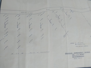 Peterborough History Group
Plan, Drainage Improvement Scheme. Mr J.S. Irvine. Peterborough
Assumed to be a plan of the drainage at The Lodge farmIndication of land levels c1970Professionally drawn plan of drainage scheme for J. S. Irvine.the lodge farm, drainage plan, j. s. irvine