Showing 659 items matching " survey plan"
-
 Bendigo Historical Society Inc.
Map - JACK FLYNN COLLECTION: BET BET, 18/08/1931
Map: Parish of Bet Bet, Counties of Gladstone and Talbot . Parish plan.By Authority H.J. Green Govt, Printer. Photo Lithographed at the Department of Lands and Survey, Melbourne. 18.8.31map, gladstone, parish plan, bet bet, counties of gladstone and talbot. -
 Bendigo Historical Society Inc.
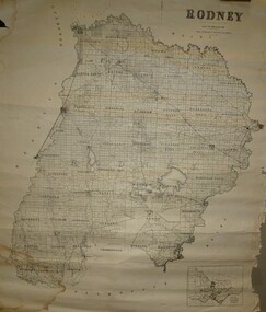
Map - JACK FLYNN COLLECTION: RODNEY, Revised in 1935
Map: County of Rodney, map sheet showing the whole of the County of Rodney and all of the Parishes within.Drawn at the Department of Lands and Survey, Melbourne. Revised to 1935map, rodney, parish plan, rodney -
 Bendigo Historical Society Inc.
Map - JACK FLYNN COLLECTION: HUNTLY, August 1954
Map: Parish of Huntly, County of Bendigo. Parish plan.By Authority W.M. Houston, Government Printer. Drawn and Reproduced at the Dept, of Lands and Survey, Melbourne, Victoria. August 1954.map, bendigo, parish plan, huntly -
 Bendigo Historical Society Inc.
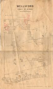
Map - JACK FLYNN COLLECTION: WELLSFORD, 2/11/1914
Map: Parish of Wellsford, County of Bendigo. Parish plan.Photo-Lithographed at the Department of Lands and Survey Melbourne By H.J. Butson. 2-.11.14map, bendigo, parish plan, wellsford -
 Bendigo Historical Society Inc.
Map - JACK FLYNN COLLECTION: GOORNONG, August 1953
Map: Township of Goornong, Parish of Goornong, County of Bendigo. Parish plan.By Authority W.M. Houston. Government Printer. Drawn and Reproduced at the Dept., of Lands and Survey, Melbourne, Victoria. August 1953map, bendigo, township, goornong -
 Bendigo Historical Society Inc.
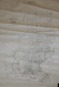
Map - JACK FLYNN COLLECTION: HUNTLY, 12.03.1932
Map: Township of Huntly, Parish of Huntly , County of Bendigo. Parish plan. Western and South Riding Division on Main St. (Main Northern Highway) - written in ink below name of map.BY Authority H.J. Green. Photo-Lithographed at the Dept., of Lands and Survey, Melbourne. 12.3.32map, bendigo, township, huntly -
 Bendigo Historical Society Inc.
Map - JACK FLYNN COLLECTION: COUNTY OF GLADSTONE, 1934
Map: County of Gladstone, map sheet showing the whole of the County and the Parishes within. Scale 2 Miles to 1 inch.Engraved at the Department of Lands and Survey Melbourne. 1958. By Authority of W.M. Houston, Government Printermap, gladstone, parish plan, gladstone -
 Bendigo Historical Society Inc.
Map - JACK FLYNN COLLECTION: YARRAYNE, 6/01/1932
Map: Parish of Yarrayne, County of Bendigo. Parish plan.By Authority, H.J. Green, Govt., Printer. Photo-Lithographed at the Department of Lands and Survey, Melbourne. 5.1.32.map, bendigo, parish plan, yarrayne -
 Bendigo Historical Society Inc.
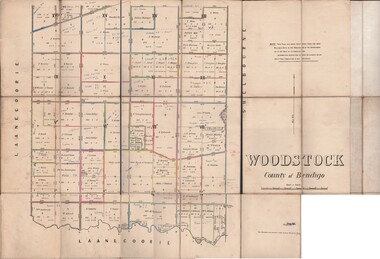
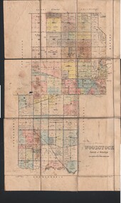
Map - JACK FLYNN COLLECTION: WOODSTOCK, 27/03/75
Map: Parish of Woodstock , County of Bendigo. Parish plan.Photo-Lithographed at the Department of Lands and Survey Melbourne by J. Noone. 27.3.79map, bendigo, parish plan, woodstock -
 Bendigo Historical Society Inc.
Map - JACK FLYNN COLLECTION: WOODSTOCK, 4/07/1935
Map: Parish of Woodstock, County of Bendigo. Parish plan.By Authority H.J. Green. Govt Printer. Drawn and Reproduced at the Dept of Lands and Survey, Melbourne Victoria. 4.7.35map, bendigo, parish plan, woodstock -
 Bendigo Historical Society Inc.
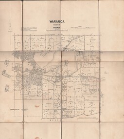
Map - JACK FLYNN COLLECTION: WARANGA, 1959
Map: Parish of Waranga, County of Rodney. Parish plan.By Authority. A.C. Brooks. Government Printer Melbourne. Drawn and Reproduced at the Department of lands and survey. Melbourne 1959.map, rodney, parish plan, waranga -
 Bendigo Historical Society Inc.
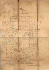
Map - JACK FLYNN COLLECTION: TOOLLEEN, 25/05.1926
Map: Parish of Toolleen, County of Rodney. Parish plan.By Authority, H.J. Green. Govt., Printer. Photo-Lithographed at the Department of Lands and Survey Melbourne. W. J. Butson 25.5.26.map, rodney, parish plan, toolleen -
 Bendigo Historical Society Inc.
Document - MCCOLL, RANKIN AND STANISTREET COLLECTION: ANGOVE AND CARRS LEASE, DIAMOND HILL, 1935
McColl Rankin & Stanistreet, Angove & Carrs Lease, Diamond Hill. a/ Manila folio Markings: Angove & Carrs Lease Diamond Hill. Freed?aus Extended. b/ Plan Area Applied For On Lease No. 10103 Ben. By A A Macintosh. Mining District of Bendigo Parish of Mandurang County of Bendigo. Inscriptions: G Birch advises 16/5/35. Survey made by Assistant he has yet to receive. 10710 W J Angove - Spring Gully PO. Dated August 12th 1933 signed: Garnet G Birch J Victor Buley. c/ Agreement of lease for 1 month with the option of 9 months, followed by the option of purchase between Summerhill Anticlines NL of Adelaide and Angove & Carr at German Gully (Mandurang). Markings: 25/3/13 note by Summerhill Anticline NL. Requests information as to whether or not the Syndicate (E Mann, W Angove & H Irvine, H. Mc……….) desire to take up the options of lease or not. d/ Notice to Shareholders of a meeting in Collins Street Melbourne. 6 March, 1935 to consider proposals of the future of the company. J G Stanfield & Stewart, Manager. e/ Neangar Gold Mining Company NL 6 Month Report 27/2/1935 Business, Director's Report & Financial Report. f/ Report by A J J Moore BCE Mining Engineer, Ramrod Lease, Golden Fleece Mine near Spring Gully Reservoir the most Southern mine being Worked in Bendigo. Lease in on the Carshalton line. Report details the progress of the workings at the mine.organization, business, gold mine, mccoll rankin & stanistreet, angove & carrs lease, diamond hill a a macintosh parish of mandurang county of bendigo w j angove august 12th 1933 summerhill anticlines 6 month report 27/2/1935 golden fleece mine near spring gully reservoir -
 Bendigo Historical Society Inc.
Map - MANDURANG, 8/10/1887
... Bendigo parish plan Mandurang Re-survey Couny of Bendigo Parish ...Parish of Mandurang, County of Bendigo. Traced from a re-survey of the Parish of Mandurang by Mr. Geo. Black 8/10.1887 ( number 158 in Map Cupboard 1)map, bendigo, parish plan, mandurang, re-survey, couny of bendigo -
 Bendigo Historical Society Inc.
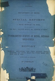
Book - UNDERGROUND SURVEY OF MINES, BENDIGO GOLDFIELD 1901, 1901
UNDERGROUND SURVEY OF MINES, BENDIGO GOLDFIELD 1901. Report on the Shamrock, Shenandoah, New Chum Railway, Eureka Extended, and South Belle Vue United Mines, New Chum Line of Reef. With plans and sections.H.S. Whitelawbendigo, hospital, gold mining, bendigo, goldfields, gold mining, shamrock, shenandoah, new chum railway, eureka extended, and south belle vue united mines, new chum line of reef. -
Bendigo Historical Society Inc.
Map - WESTON, 21/10/1876
Map: Re-Survey of part of the parish of Weston, County of Rodney. Parish plan (number 309 in map cupboard 1)Murray and Hargreave, Authorised surveyorsmap, rodney, parish plan, parish of weston, murray and hargreave -
Bendigo Historical Society Inc.
Map - PART OF ELLESMERE, 20/06/1875
... Bendigo parish plan Ellesmere Map: Re-survey of part of the Parish ...Map: Re-survey of part of the Parish of Ellesmere, hand draughted Parish plan Reloacated to Map Drawer 5 on 22.9.2022. Hanging strip detached.map, bendigo, parish plan, ellesmere -
 St Kilda Historical Society
Photograph - Photo map, 28/01/1951
One of a series of photo-maps produced for the Department of Crown Lands and Survey (1857-1983). For correlation with a current map, and access to other historical photo maps of Victoria, see the Historic Photo-Maps Index published by the Department of Environment, Land, Water and Planning at https://services.land.vic.gov.au/DELWPmaps/historical-photomaps/Black and white aerial photograph1424-45 SECRET 534 Run 18 Lens 12" Melbourne Metropolitan 12150 28.1.51 M639albert park, st kilda junction, st kilda pier, catani gardens, st kilda, prahran, albert park lake, 1951, middle park, st kilda beach, windsor -
 St Kilda Historical Society
Photograph - Photo map, 17/01/1951
One of a series of photo-maps produced for the Department of Crown Lands and Survey (1857-1983). For correlation with a current map, and access to other historical photo maps of Victoria, see the Historic Photo-Maps Index published by the Department of Environment, Land, Water and Planning at https://services.land.vic.gov.au/DELWPmaps/historical-photomaps/Black and white aerial photograph1414-21 538 Run 19 Lens 12" Melbourne Metropolitan 12150 17.1.51 M586st kilda, st kilda botanical gardens, peanut farm, elwood, 1951, point ormond, elwood canal, st kilda beach -
 St Kilda Historical Society
Photograph - Photo map, 28/01/1951
One of a series of photo-maps produced for the Department of Crown Lands and Survey (1857-1983). For correlation with a current map, and access to other historical photo maps of Victoria, see the Historic Photo-Maps Index published by the Department of Environment, Land, Water and Planning at https://services.land.vic.gov.au/DELWPmaps/historical-photomaps/Black and white aerial photograph1424-118 534 Run 20 Lens 12" Melbourne Metropolitan 12150 18.1.51M639elwood, point ormond, elwood park, elsternwick park, elwood beach, 1951 -
 St Kilda Historical Society
Photograph - Photo map, 17/01/1951
One of a series of photo-maps produced for the Department of Crown Lands and Survey (1857-1983). For correlation with a current map, and access to other historical photo maps of Victoria, see the Historic Photo-Maps Index published by the Department of Environment, Land, Water and Planning at https://services.land.vic.gov.au/DELWPmaps/historical-photomaps/Black and white aerial photograph1414-20 538 Run 19 Lens 12" Melbourne Metropolitan 12150 17.1.51 M586elwood, elsternwick, st kilda east, balaclava, ripponlea, 1951 -
 St Kilda Historical Society
Photograph - Photo map, 28/01/1951
One of a series of photo-maps produced for the Department of Crown Lands and Survey (1857-1983). For correlation with a current map, and access to other historical photo maps of Victoria, see the Historic Photo-Maps Index published by the Department of Environment, Land, Water and Planning at https://services.land.vic.gov.au/DELWPmaps/historical-photomaps/Black and white aerial photograph1424-44 534 Run 18 Lens 12" Melbourne Metropolitan 12150 28.1.51 M639 -
 St Kilda Historical Society
Photograph - Photo map, 28/01/1951
One of a series of photo-maps produced for the Department of Crown Lands and Survey (1857-1983). For correlation with a current map, and access to other historical photo maps of Victoria, see the Historic Photo-Maps Index published by the Department of Environment, Land, Water and Planning at https://services.land.vic.gov.au/DELWPmaps/historical-photomaps/Black and white aerial photograph1424-43 534 Run 18 Lens 12" Melbourne Metropolitan 12150 28.1.51 M639armadale, malvern, st kilda cemetery, caulfield north, st kilda east, 1951 -
 St Kilda Historical Society
Photograph - Photo map, 30/01/1960
One of a series of photo-maps produced for the Department of Crown Lands and Survey (1857-1983). For correlation with a current map, and access to other historical photo maps of Victoria, see the Historic Photo-Maps Index published by the Department of Environment, Land, Water and Planning at https://services.land.vic.gov.au/DELWPmaps/historical-photomaps/Black and white aerial photographVic 1093-62 Melbourne & Metropolitan Project Run 21 30.1.60 Lens 10" 8.200middle park, albert park, catani gardens, st kilda west, 1960 -
 St Kilda Historical Society
Photograph - Photo map, 30/01/1960
One of a series of photo-maps produced for the Department of Crown Lands and Survey (1857-1983). For correlation with a current map, and access to other historical photo maps of Victoria, see the Historic Photo-Maps Index published by the Department of Environment, Land, Water and Planning at https://services.land.vic.gov.au/DELWPmaps/historical-photomaps/Black and white aerial photographVic 1093-60 Melbourne & Metropolitan Project Run 21 30.1.60 Lens 10" 8.200st kilda, albert park, prahran, windsor, south yarra, 1960 -
 St Kilda Historical Society
Photograph - Photo map, 30/01/1960
One of a series of photo-maps produced for the Department of Crown Lands and Survey (1857-1983). For correlation with a current map, and access to other historical photo maps of Victoria, see the Historic Photo-Maps Index published by the Department of Environment, Land, Water and Planning at https://services.land.vic.gov.au/DELWPmaps/historical-photomaps/Black and white aerial photographVic 1092-36 Melbourne & Metropolitan Project Run 22 30.1.60 Lens 10" 8.200st kilda, st kilda pier, st kilda beach, catani gardens, 1960 -
 St Kilda Historical Society
Photograph - Photo map, 30/01/1960
One of a series of photo-maps produced for the Department of Crown Lands and Survey (1857-1983). For correlation with a current map, and access to other historical photo maps of Victoria, see the Historic Photo-Maps Index published by the Department of Environment, Land, Water and Planning at https://services.land.vic.gov.au/DELWPmaps/historical-photomaps/Black and white aerial photographVic 1092-38 Melbourne & Metropolitan Project Run 22 30.1.60 Lens 10" 8.200st kilda, st kilda beach, st kilda pier, catani gardens, 1960, st kilda botanical gardens, peanut farm -
 St Kilda Historical Society
Photograph - Photo map, 30/01/1960
One of a series of photo-maps produced for the Department of Crown Lands and Survey (1857-1983). For correlation with a current map, and access to other historical photo maps of Victoria, see the Historic Photo-Maps Index published by the Department of Environment, Land, Water and Planning at https://services.land.vic.gov.au/DELWPmaps/historical-photomaps/Black and white aerial photographVic 1092-40 Melbourne & Metropolitan Project Run 22 30.1.60 Lens 10" 8.200st kilda east, balaclava, ripponlea, st kilda cemetery, 1960 -
 St Kilda Historical Society
Photograph - Photo map, 30/01/1960
One of a series of photo-maps produced for the Department of Crown Lands and Survey (1857-1983). For correlation with a current map, and access to other historical photo maps of Victoria, see the Historic Photo-Maps Index published by the Department of Environment, Land, Water and Planning at https://services.land.vic.gov.au/DELWPmaps/historical-photomaps/Black and white aerial photographVic 1092-42 Melbourne & Metropolitan Project Run 22 30.1.60 Lens 10" 8.200malvern, caulfield, caulfield park, 1960 -
 St Kilda Historical Society
Photograph - Photo map, 30/01/1960
One of a series of photo-maps produced for the Department of Crown Lands and Survey (1857-1983). For correlation with a current map, and access to other historical photo maps of Victoria, see the Historic Photo-Maps Index published by the Department of Environment, Land, Water and Planning at https://services.land.vic.gov.au/DELWPmaps/historical-photomaps/Black and white aerial photographVic 1091-112 Melbourne & Metropolitan Project Run 23East 30.1.1960 Lens 10" 8.200elwood, point ormond, elwood park, elwood canal, 1960