Showing 1122 items matching " waterways"
-
 Lakes Entrance Historical Society
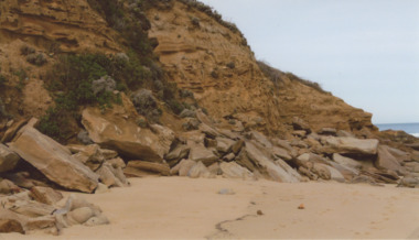
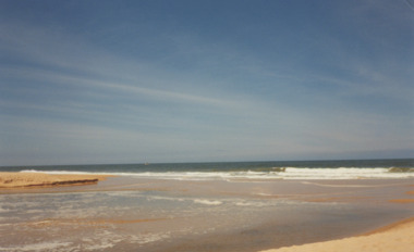
Photograph - Red Bluff 2008, Wendy Price, 1/08/2008 12:00:00 AM
... Waterways ...This is the after photograph used in the 150 years Lakes Entrance 1858 to 2008 display held in October 2008 paired with image 03731 for displayColour photograph of west side of Red Bluff showing vegetation on the bluff rock and sand at the base situated on ninety mile beach Lake Tyers Victoria waterways, topography -
 Lakes Entrance Historical Society
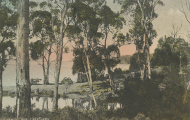
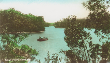
Postcard - Lake Tyers, VSM Series 112942, 1905c
... Waterways ...Tinted postcard of Kaligurnia Cove showing calm lake beyond tall sparse timber, boat on lake, three people at waters edge Lake Tyers VictoriaKaligurnia Cove, Lake Tyerswaterways, forestry -
 Lakes Entrance Historical Society
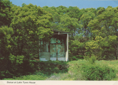
Photograph - Lake Tyers House, NU Color Vve, 1970c
... Waterways ...Postcard was Produced for sale by Lake Tyers Scenic Boat TripsColour postcard of crucifix statue in grotto surrounded by scrub and timber Lake Tyers House Lake Tyers VictoriaStatue at Lake Tyers Housejetties, waterways -
 Lakes Entrance Historical Society
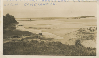
Photograph - Lake Tyers
... Waterways ...Second similar image plus six small photographs taken of Lake Tyers 03825.1, 03825.2, 03825.3, 03825.4, 03825.5, 03825.6, 03825.7 size 6 x 8.5 cmBlack and white photograph of Cross's Landing showing lake, shoreline with frames for fishing nets small boat on sand, jetty beyond track to lake edge Lake Tyers VictoriaLake Tyers where lake is near the ocean Crossforest, waterways -
 Lakes Entrance Historical Society
Photograph - Lake Tyers, Bulmer photography
... Waterways ...Also two original postcards one tinted and one black and white numbers 03826.2 and 3826.3 size 6.5 x 10.5 cmTinted photograph of showing tourist boat possible Firefly on lake, thick forest around lake. Lake Tyers VictoriaLake Tyers Victoriaboats and boating, waterways -
 Lakes Entrance Historical Society
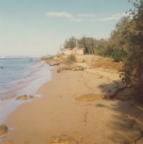
Photograph - Lake Tyers, Marie Fish, 1978
... Waterways ...Two other colour photographs taken of damage from storms June/July 1978 showing that sand dune between lake and ocean was swept away, road and toilet block undermined numbers 03831.1 and 3831.2 size 9 x 8.5 cmColour photographs showing damage to shore and track to entrance at Lake Tyers Beach Victoriabeaches, waterways -
 Lakes Entrance Historical Society
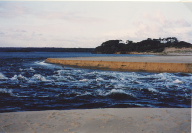
Photograph - Lake Tyers, Lakes Post Newspaper, 1/08/2001 12:00:00 AM
... Waterways ...Colour photograph showing turbulant water at the new entrance at Lake Tyers showing western barrier of the lake in background and sand dune in foreground being washed away Lake Tyers Victoriawaterways, beaches -
 Lakes Entrance Historical Society
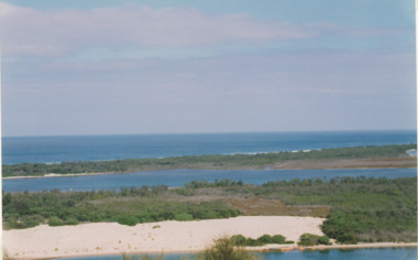
Photograph - Lakes Entrance, M Holding, 1/03/2004 12:00:00 AM
... Waterways ...Colour photograph taken from Kalimna viewing platform from Rigby to outer barrier and Bass Strait beyond, East Gippsland Victoriawaterways, lakes entrance -
 Lakes Entrance Historical Society
Photograph - Lake Bunga, M Holding, 1/06/1998 12:00:00 AM
... Waterways ...Also a second coloured photograph showing expanse of sand on western shore with Mrs Glad Scarce seated on fence looking at open entrance Lake Bunga number 03849.1 size 10 x 15 cmColour photograph of the open entrance after an unusual weather condition Lake Bunga Victoriawaterways, lake bunga -
 Lakes Entrance Historical Society
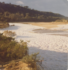
Photograph - Lake Bunga, Marie Fish, 1987c
... Waterways ...Also three other colour phoptographs of foam at entrance and on lake after severe storm in June July 1978 numbers 03847.1, 03847.2, 03847.3 size 9 x 8.5 cmColour photograph showing foam across the open entrance after a severe storm, timbered hill in distance, Lake Bunga Victoriatopography, waterways -
 Lakes Entrance Historical Society
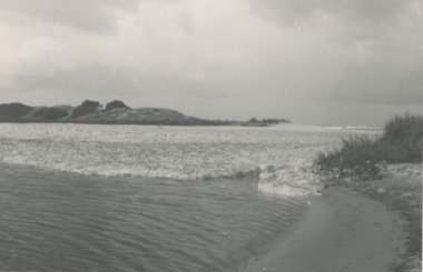
Photograph, Lake Bunga and ocean Victoria
... Waterways ...Taken after a recent flood event. The ocean waters foam when it meets fresh water. Black and white photograph of the entrance to Lake Bunga Victoriaocean, waterways -
 Clunes Museum
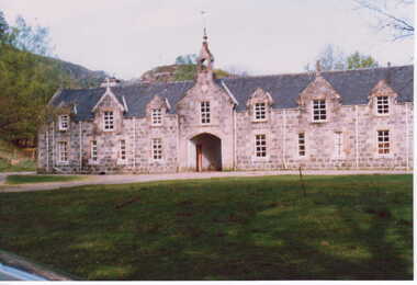
Photograph, UNKNOWN
1.2. COLOUR PHOTOGRAPHS CLUNES CASTLE. HOME OF SIR DONALD CAMERON OF LOCHEIL. 3.4. COLOUR PHOTOGRAPHS CLUNES STABLES. 5. " " CLAN CAMERON MUSEUM IN GROUNDS OF CLUNES 6.COLOUR PHOTOGRAPH PART OF EXTENSIVE WATERWAYS ON THE ESTATE. THE FISHING RIGHTS OF WHICH ARE LET OUT TO THE BISSET SALMON COMPANY IN UK. 7.COLOUR PHOTOGRAPH OF DONALD YOUNGER SON LOCHIEL WITH DR. IAN CAMERON AT CLUNES HOUSE IN SCOTLAND SCANNED COPIES OF ALL THESE ARE IN THE IMAGES FOLDERlocal history, photography, photographs, cameron, donald -
 Eltham District Historical Society Inc
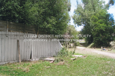
Photograph, Fay Bridge, Flood damage at Nillumbik Medical Centre, 1078 Main Road, Eltham, 26 December 2011
Flood damage resulting from a late afternoon storm on Christmas Day 2011. A flash flood occurred from significant rain fall and hail, which accumulated along an old waterway with floodwater submerging cars along Valonia Drive then down Grove Street flooding houses, through the Bible Street Reserve where it then submerged Main Road washing away the small railway trestle bridge opposite the reserve then flooding the Judge Book Village before finally entering the Diamond Creek..fay bridge collection, 2011-12-26, bible street reserve, flood damage, floods, floodwater, main road, nillumbik medical centre -
 Eltham District Historical Society Inc
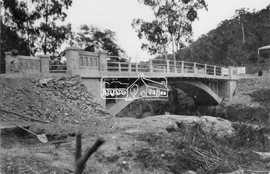
Negative - Photograph, New bridge at Hurstbridge, 1917
The newly constructed re-inforced concrete arched bridge across the Diamond Creek at Hurstbridge designed by John Monash. Eltham Shire shared the cost of the construction of the bridge with Heidelberg and Whittlesea Shires. The bridge was officially opened on 3rd November 1917. Part of a slide show presentation "Bridges & Waterways of the Shire" by Russell Yeoman to the 13 September 1989 Society meeting. The presentation included slides of historic photos from the Shire of Eltham Pioneers collections as well as several recent views.This photo forms part of a collection of photographs gathered by the Shire of Eltham for their centenary project book, "Pioneers and Painters: 100 years of the Shire of Eltham" by Alan Marshall (1971). The collection of over 500 images is held in partnership between Eltham District Historical Society and Yarra Plenty Regional Library (Eltham Library) and is now formally known as 'The Shire of Eltham Pioneers Photograph Collection.' It is significant in being the first community sourced collection representing the places and people of the Shire's first one hundred years.Digital image 4 x 5 inch B&W Negshire of eltham pioneers photograph collection, hurstbridge, bridge, 1917, diamond creek (creek), monash bridge -
 Surrey Hills Historical Society Collection
Book, A History of Camberwell, 1964
Includes description including photographs of Camberwell Junction and Burke Road, pre 1950's era. Electric transport 1916-1925, tools and waterways. Published [Brisbane] : Jacaranda Press in association with the Camberwell City Council, 1964 From estate of Ken Hall; Cheryl Poustie was Ken's daughter. Records in detail history and development of the Melbourne suburb of Camberwell. A city covering thirteen square miles. Begins with first European settlement in 1835 by John Gardiner - ending at 1960.Records in detail history and development of the Melbourne suburb of Camberwell. A city covering thirteen square miles. Begins with first European settlement in 1835 by John Gardiner - ending at 1960.Title Page: Kenneth T.Hall / 89-4418camberwell - history, (mr) john gardiner, outer circle railway, camberwell (vic) - history, broughton hall -
 Eltham District Historical Society Inc
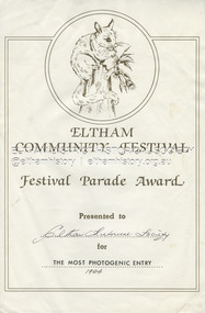
Document - Award Certificate, Eltham Community Festival, Festival Parade Award Presented to Eltham Historical Society for The Most Photogenic Entry, 1984
1984: 17 November. “Pioneers of Eltham” The Society arranged a float for the Festival parade with members dressed appropriately to the theme "Pioneers of Eltham". Participants assembled at 11.30am in Cecil Street with the parade commencing at 12 noon. As in past parades a number of members of the Victorian Folk Music Club accompanied the float and members, the group greatly added to the occasion with their happy music. The Society also arranged a display at the Eltham Community Centre in association with the activities there over the Festival weekend. The theme of the display was waterways of the local area.1984, award, eltham community festival, eltham festival, festival parade award, grand parade, shire of eltham historical society -
 Eltham District Historical Society Inc
Newsclipping, Vince Chadwick, Violent storms shatter the peace of Christmas, The Age, Monday, December 26, p3, 2011
A late afternoon storm on Christmas Day 2011. A flash flood occurred from significant rain fall and hail, which accumulated along an old waterway with floodwater submerging cars along Valonia Drive then down Grove Street flooding houses, through the Bible Street Reserve where it then submerged Main Road washing away the small railway trestle bridge opposite the reserve then flooding the Judge Book Village before finally entering the Diamond Creek. Widespread damage occured from hail and flash flooding.fay bridge collection, 2011-12-26, eltham, flood damage, floods, grove street, main road, valonia drive -
 Eltham District Historical Society Inc
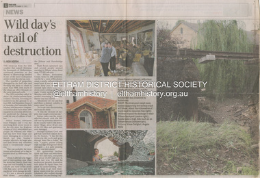
Newsclipping, Reid Sexton, Wild day's trail of destruction, The Age, Tuesday, December 27, pp4-5, 2011
A late afternoon storm on Christmas Day 2011. A flash flood occurred from significant rain fall and hail, which accumulated along an old waterway with floodwater submerging cars along Valonia Drive then down Grove Street flooding houses, through the Bible Street Reserve where it then submerged Main Road washing away the small railway trestle bridge opposite the reserve then flooding the Judge Book Village before finally entering the Diamond Creek. Widespread damage occured from hail and flash flooding.fay bridge collection, eltham, 2011-12-27, flood damage, floods, floodwater -
 Eltham District Historical Society Inc
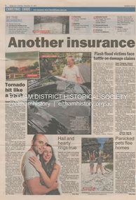
Newsclipping, Angus Thompson et al, Another insurance storm brews, Herald Sun, Tuesday, December 27, pp4-5, 2011
A late afternoon storm on Christmas Day 2011. A flash flood occurred from significant rain fall and hail, which accumulated along an old waterway with floodwater submerging cars along Valonia Drive then down Grove Street flooding houses, through the Bible Street Reserve where it then submerged Main Road washing away the small railway trestle bridge opposite the reserve then flooding the Judge Book Village before finally entering the Diamond Creek. Widespread damage occured from hail and flash flooding.fay bridge collection, eltham, 2011-12-27, flood damage, floods, floodwater -
 Eltham District Historical Society Inc
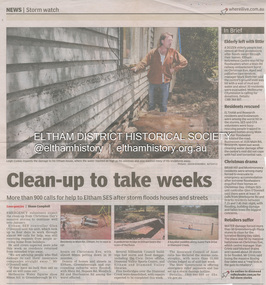
Newsclipping, Shaun Campbell, Clean-up to take weeks, Diamond Valley Leader, December 2011
A late afternoon storm on Christmas Day 2011. A flash flood occurred from significant rain fall and hail, which accumulated along an old waterway with floodwater submerging cars along Valonia Drive then down Grove Street flooding houses, through the Bible Street Reserve where it then submerged Main Road washing away the small railway trestle bridge opposite the reserve then flooding the Judge Book Village before finally entering the Diamond Creek. Widespread damage occured from hail and flash flooding.fay bridge collection, eltham, flood damage, floods, floodwater -
 Eltham District Historical Society Inc
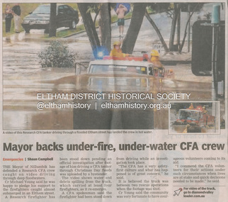
Newsclipping, Shaun Campbell, Mayor backs under-fire, under-water CFA crew, Diamond Valley Leader, December 2011
A late afternoon storm on Christmas Day 2011. A flash flood occurred from significant rain fall and hail, which accumulated along an old waterway with floodwater submerging cars along Valonia Drive then down Grove Street flooding houses, through the Bible Street Reserve where it then submerged Main Road washing away the small railway trestle bridge opposite the reserve then flooding the Judge Book Village before finally entering the Diamond Creek. Widespread damage occured from hail and flash flooding.fay bridge collection, eltham, flood damage, floods, floodwater, main road, research fire brigade -
 Eltham District Historical Society Inc
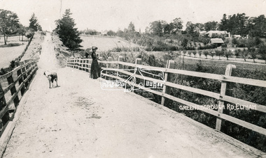
Photograph, Bridge over the Diamond Creek, Greensborough Road, Eltham, c.1885
Original (1874) bridge in Bridge Street, Eltham looking east over the Diamond Creek towards Maria Street (Main Road) at Little Eltham. In the distance to the right on Maria Street is the Methodist Church (1881), now Uniting Church, and the adjacent Commercial Bank of Australia branch building (1878). Part of a slide show presentation "Bridges & Waterways of the Shire" by Russell Yeoman to the 13 September 1989 Society meeting. The presentation included slides of historic photos from the Shire of Eltham Pioneers collections as well as several recent views.Photo of original 1875 timber and gravel surface bridge over the Diamon Creek in Bridge Street with views of orchards representative of the farming lands as well as the development along the northern end of Maria Street.Black and white photograph copybridge street, bridge street bridge, cba bank, diamond creek (creek), eltham, little eltham, main road, maria street, methodist church, uniting church -
 Eltham District Historical Society Inc
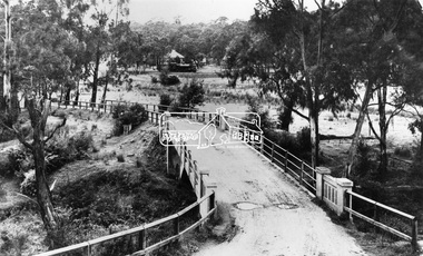
Negative - Photograph, View across bridge at Hurstbridge, Vic, c.1922
View across the new Monash bridge across the Diamond Creek at Hurstbridge looking towards the township, note steam train in centre background of image. Dated between the opening of bridge Nov. 1917 and provision of electric rail service Aug. 1926 - c.1922. Part of a slide show presentation "Bridges & Waterways of the Shire" by Russell Yeoman to the 13 September 1989 Society meeting. The presentation included slides of historic photos from the Shire of Eltham Pioneers collections as well as several recent views.This photo forms part of a collection of photographs gathered by the Shire of Eltham for their centenary project book ,"Pioneers and Painters: 100 years of the Shire of Eltham" by Alan Marshall (1971). The collection of over 500 images is held in partnership between Eltham District Historical Society and Yarra Plenty Regional Library (Eltham Library) and is now formally known as 'The Shire of Eltham Pioneers Photograph Collection.' It is significant in being the first community sourced collection representing the places and people of the Shire's first one hundred years.Digital image 4 x 5 inch B&W Negshire of eltham pioneers photograph collection, hurstbridge, bridge, steam train, diamond creek (creek), railway line, monash bridge -
 Bendigo Historical Society Inc.
Postcard - FERNERY, ROSALIND PARK, BENDIGO
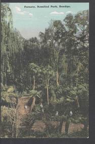
colour postcard: Fernery, Rosalind park, Bendigo. Image shows Fernery in Rosalind Park, Bendigo. Lush foliage, including tree ferns, taller eucalypt trees in background. 4 children in foreground, one standing on bridge over waterway. On rear written in black pen: ' this is a good one of the Park, don't you think - I suppose you remember when we went there - With love, May.' Addressed to Miss E M Dahlsen, Nicholson Street, Bairnsdale. Stamp has Victoria, One penny, printed.bendigo, parks and gardens, fernery, rosalind park, bendigo, fernery, rosalind park -
 Whitehorse Historical Society Inc.
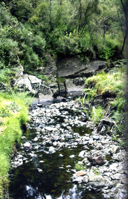
Photograph, Deep Creek, Mitcham, 2012
... waterways ...Coloured photograph of Deep Creek, Mitcham near the foot bridge on the Eastlink Trail - 2012deep creek, mitcham, waterways -
 Lakes Entrance Historical Society
Photograph, 2005
... Waterways ...Date made September 2005Colour photograph of the RMIT TAFE Educational Facility on Bullock Island, taken from Cunninghame Arm, in the back ground are communication towers on Kalimna Heights. The Kalimna escarpment contrasts with the low lying sand formation of Bullock Island. Lakes Entrance Victoriaislands, education, waterways -
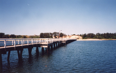 Lakes Entrance Historical Society
Photograph, 1999
... Waterways ...Colour photograph of the Cunninghame Arm Footbridge, showing the excavation of sand after removal of Kiosk, prior to construction of new Surf Lifesaving Clubrooms. Lakes Entrance Victoriabridges, waterways, construction -
 Lakes Entrance Historical Society
Photograph, Lakes Post Newspaper, April 1999
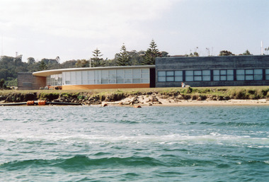
... Waterways ...Also a second colour photograph taken at same event showing Marie Tahan and Barrie Martin 04690.2Colour photograph of Bruce Warr Gippsland Ports Chairman, Marie Tahan Minister for CFL and Barrie Martin Gippsland Ports CEO at launching of new safety bollard at entrance Lakes Entrance Victoriadredging, environment, waterways -
Lakes Entrance Historical Society
Photograph, 14/04/2013 12:00:00 AM
... Waterways ...Colour aerial photograph of Entrance at New Works showing the sand transfer building Lakes Entrance VictoriaNew Worksaerial photograph, waterways, topography -
Lakes Entrance Historical Society
Book, Alison Goding, This Bold Venture the story of Lake Tyers House Place and People, 1990
... Waterways ...The story of Lake Tyers House, situated on Lake Tyers, Victoria, and the people associated with this early tourism venture. The settlement and development of the region is also dealt with and photographs are included.guesthouses, waterways, land settlement