Showing 16158 items
matching 1941-now.
-
 Slovenian Association Melbourne
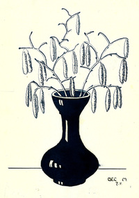
ink drawing, Marcela Bole - ink drawing 1925, 1925
Marcela Gec was attending Italian convent school, because the territory of Slovenia was under the Italian rule. It had to be her own design to be able to create the embroideryInk drawing on cartridge paper of the hazel nut bush blossoms in late winter.Marcela Gec, 1925marcela bole, drawing, ink, hazel nut bush, slovenian association melbourne, slovenian embroidery -
 Whitehorse Historical Society Inc.
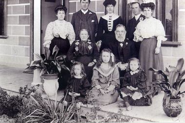
Photograph, McDonnell Family
Photograph was donated by Margaret White (nee Kennedy) granddaughter Jane & John McDonnell.Two copies of black and white photograph of Jane and John McDonnell and family members on the verandah of their home at 42 McDowall Street Mitcham..Left to right - Catherine Lardner, P.J. McDonnell, Margaret McDonnell, Michael McDonnell, Jean Kunze.Middle row - Jane McDonnell and John McDonnell (Margaret's grandparents)Front row - Gladys Lardner, Florence Greet, Irene Lardnerwhite, margaret, mcdonnell, p.j., lardner, catherine, gladys, irene, michael, kunze, jean, john, jane, greet, florence, mitcham hotel -
 Ballarat Tramway Museum
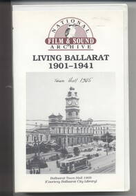
Film - Video cassette tape and box, Chris Long, "Living Ballarat 1901 - 1941", 1990
Yields information through movie films of the 1960's of Ballarat trams operating in the streets of Ballarat and has a strong association with the maker - National Film and Sound Archives and Chris Long.Video cassette in a plastic case, titled "Living Ballarat - 1901 - 1941, National Film and Sound Archive (1990)". See Reg item 4519 for the DVD version. The DVD was made by Peter Winspur using this tape. Transferred to the Hard Drive 11/1/2010- AV Files - dB text/AV Files/Reg Item 4519/Video_TS (at 12/1/2010) Copyright provisions - National Film and Sound Archive - segments may not be used without their permission, viewing only. Synopsis: based on time - 0.00 - intro, 1901 film, Melbourne, first film in Ballarat, Royal visit to Ballarat, Boer War Monument, first feature length film in Ballarat. 2.50 - Bridge St and Sturt St scenes, filmed from a flat truck pushed by an electric tram, including No. 11 going to City Oval to Lydiard St. 5.00 - Sturt St Military parade, with trams in background and tram running alongside. 6.54 - scene of Alfred Hall and films. 7.32 - scene on Lake Wendouree and paddle steamer - Living Ballarat film - Pathe's Ballarat Gazette local film unit, football ground scene. a children's beauty competition, tree planting at Macarthur St state school, 1911 Ballarat Show, unveiling of the Boer War statue name plates, Lake Wendouree 1912. 13.22 - St Patricks David Pde with trams in the background. 14.24 - Ballarat Kennel club dog show. 15.50 - Royal visit in 1920, Arch of victory opening 17.48 - Day at Macarthur St state school and tree plantation 20.55 - Bakery Hill - Stones Corner with tram tracks, cars, little trams, Sturt St with a tram leaving Grenville St, ESCo 9 turning from Lydiard St to run down to Grenville St. 22.15 - Ballarat Show, Coliseum Hall, 1925, races, machinery shows, boxing troupe. 25.20 - Botanic Gardens Gates, Lake Wendouree area. 25.30 - Gem Picture travelling show - film 26.16 - Formal visit of English pressman to Ballarat, 1925, Botanic Gardens, Eureka Stockade, Avenue of Honor, Moorabool Reservoir. 29.15 - 1927 Fed Govt doco of Ballarat, Black Hill, 1927 Home to Ballarat Festival, Ballarat Commemorative song, Craigs Hotel, Ballarat Post Office, tram centre poles in Lydiard St, tram climbing Sturt St, Town Hall, tram at Lydiard St terminus coursing, 8, Sturt St, view of ESCo Sebastopol car leaving Grenville St, Selkirks Brickworks, the Welcome nugget, Peter Lalor statue, Eureka stockade, sewerage plant, modern housing, Sturt St west, water supply - golf club, the High School, the orphanage, fine homesteads around Ballarat, Lake Wendouree. 41.00 Opening of the Ballarat Aerodrome. 43.11 - Depression work and leading into radio broadcasting - 3BA open 1930, typewriters, radio transmission equipment, radio aerials, boys listening to crystal sets 47.50 - Bluebirds Children session tour to the Gardens, mentions the BTPS, trams 13, 3? and 14 carrying visitors arriving and getting off and picnic. 48.50 - expansion of 3BA transmitter capacity 51.30 - 1934 visit of the Duke of Gloucester - visit to the Lucas factory, views of the work floor and the factory history and then South St band competition at the Showgrounds. 55.10 - South St Music Festivals, Coliseum and fire. 56.25 - Ballarat Floral Festival March 1938 - Victorian Railways arch of welcome. 57.25 - segment in the shot of 12 and 19? in Sturt St 57.45 - colour segment of the festival, 58.39 - Grenville St tram shelter, Bridge St, Sturt St, arches, Main Road, Council Road Roller, Victoria St, Eureka Stockade Reserve, Botanic Gardens, setting up the flowers, wax papers. 1.01.48 - decorated tram, north side of Sturt St, details of the materials used, Crockers. 1.03.20 - Hospital Fund Raising Gala Day - March 1938, special trains arriving Ballarat Railway Station, fund raising procession, pageant at the Showgrounds, fly past. 1.07.35 - 1939 Summer, motor cycle races at Learmonth, City Oval fire brigade demonstrations, Ballarat (East) Fire Station decorated for the 1939 Floral Festival with tram in the background and No. 29, Floral Tram and others. 1.09.25 - July 1914 - Ballarat at War parade, troops. 1.10.10 - credits. Box has images of a tram and town hall on the front and details of the contents on the rear and who made it etc. See images for details. ballarat, 3ba, floral tram, royal visit, buildings, esco -
 Robin Boyd Foundation
Slide, Robin Boyd, 1950
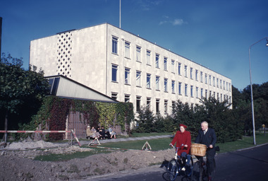
Penleigh Boyd, Robin and Patricia Boyd's son, writes “Prior to 1950 Robin, like most other amateur or hobby photographers, took black and white printed photographs. The oldest slides date from 1950 when Robin and Patricia travelled to Europe on Robin’s Robert Haddon Travelling Scholarship.” In 1948 Robin Boyd was awarded ‘joint first place’ in the Robert Haddon competition for his design of Mildura art gallery. The scholarship helped fund their first overseas trip. Robin and Patricia were passengers on the Greek ship “Cyrenia” departing in May 1950, passing through the Suez Canal and landing in Genoa five weeks later. For six months, they travelled extensively throughout Europe (predominantly driving themselves) - France, Italy, United Kingdom, Sweden, Denmark, Germany, Austria, Switzerland and Spain.Colour slide in a mount. Building (1941), University of Copenhangen, Copenhagen, Denmark . (Architect: Kaj Gottlob.)Copenhagen / University / Universoty Arch. Kaj Gottlob / 1941 (All Handwritten)haddon travelling scholarship, haddon, robin boyd, slide -
 Bendigo Military Museum
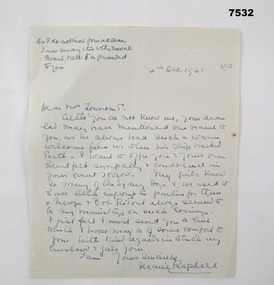
Letter - LETTER of SYMPATHY, 4 Dec 1941
Letter of Sympathy sent to parents of Dental Surgeon "Mervyn Townsend" KIA on the sinking of HMAS SYDNEY by German Raider HSK Kormoran on 19/11/41 of WA Coast. Refer Cat No. 2313P for Townsends service.Letter of Sympathy handwritten on blank green piece of notepaper. Writing in blue pen and dated 4th Dec 1941.Note at top: "As I do not know your address I am sending this to the Naval Board Melb, to be forwarded to you". Dated 4th Dec 1941 W.A. hmas sydney, ww2, hsk kormoran, mervyn clive townsend -
 Ringwood and District Historical Society
Photograph, Leaving Debbie Place, North Ringwood, now ready for metalling on 3 November 1978
E551 N12 Part of a 51-photo record of the development of the "Kubis" Estate, Ringwood North, including road works to Debbie Place, Kubis Drive, Werac Drive, Manuelo Drive, Iluka Place and Glenvale Road. From the Jack Lundy Clarke collection.51 -
 Ringwood and District Historical Society
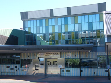
Photograph, Former Ringwood Library in Melbourne Street around 147-9 Maroondah Highway in 2008. Now demolished for Eastland expansion
Photographic record by Russ Haines, RDHS, in 2008. -
 Ringwood and District Historical Society
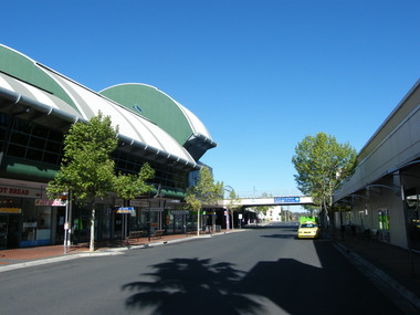
Photograph, Various shops at 171 Maroondah Highway, between Melbourne Street and earlier Eastland complex, in 2008. Now demolished for new Eastland expansion
Photographic record by Russ Haines, RDHS, in 2008. -
 Ringwood and District Historical Society
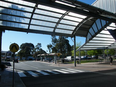
Photograph, Covered walkway at 171 Maroondah Highway, between Melbourne Street and earlier Eastland complex, in 2008. Now demolished for new Eastland expansion
Photographic record by Russ Haines, RDHS, in 2008. -
 Ringwood and District Historical Society
Photograph, Former Melbourne Street showing various shops and businesses, including NAB Bank, in 2008. Now demolished for new Eastland expansion
Photographic record by Russ Haines, RDHS, in 2008. -
 Ringwood and District Historical Society
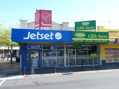
Photograph, 151-155 Maroondah Highway, looking north, in 2008. Showing Jetset travel agency, the Cash Store and Chemist Warehouse. Now demolished for REALM Library
Photographic record by Russ Haines, RDHS, in 2008. -
 Ringwood and District Historical Society
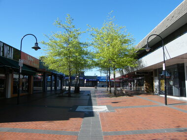
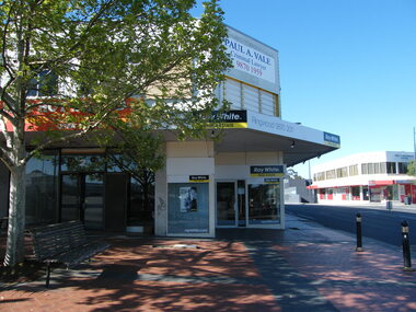
Photograph, Corner of Civic Place (now a footpath) and Ringwood Street, Ringwood towards the south, in 2008. Showing Ray White real estate and Holt & Macdonald, solicitor
Photographic record by Russ Haines, RDHS, in 2008. -
 Ringwood and District Historical Society
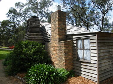
Photograph, Showing the exterior views of the facsimile of the miner's hut, located at the back of Ringwood Lake, from the original that once stood on Maroondah Highway in the 1870s onwards. The cottage was erected by the Ringwood City Council in conjunction with Ringwood Historical Research Group (now Ringwood & District Historical Society). Officially opened by Mayor Cr Pat Gotlib JP on 29th May 1983
Photographic record by Russ Haines, RDHS, in October 2008. -
 Ringwood and District Historical Society
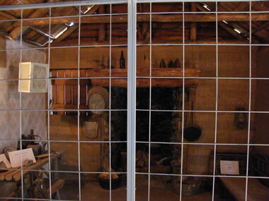
Photograph, Showing the interior views of the facsimile of the miner's hut, located at the back of Ringwood Lake, from the original that once stood on Maroondah Highway in the 1870s onwards. The cottage was erected by the Ringwood City Council in conjunction with Ringwood Historical Research Group (now Ringwood & District Historical Society). Officially opened by Mayor Cr Pat Gotlib JP on 29th May 1983
Photographic record by Russ Haines, RDHS, in October 2008. -
 Ringwood and District Historical Society
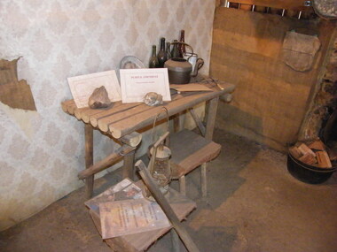
Photograph, Showing the tools and equipment rooms of the facsimile of the miner's hut, located at the back of Ringwood Lake, from the original that once stood on Maroondah Highway in the 1870s onwards. The cottage was erected by the Ringwood City Council in conjunction with Ringwood Historical Research Group (now Ringwood & District Historical Society). Officially opened by Mayor Cr Pat Gotlib JP on 29th May 1983
Photographic record by Russ Haines, RDHS, in October 2008. -
 Ringwood and District Historical Society
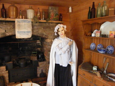
Photograph, Showing the living rooms of the facsimile of the miner's hut, located at the back of Ringwood Lake, from the original that once stood on Maroondah Highway in the 1870s onwards. The cottage was erected by the Ringwood City Council in conjunction with Ringwood Historical Research Group (now Ringwood & District Historical Society). Officially opened by Mayor Cr Pat Gotlib JP on 29th May 1983
Photographic record by Russ Haines, RDHS, in October 2008. -
 Ringwood and District Historical Society
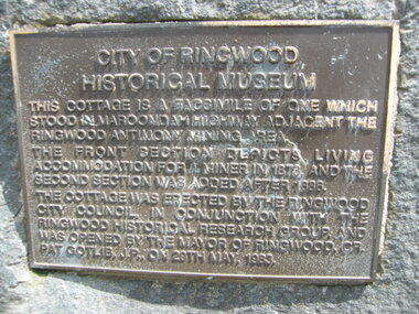
Photograph, The official plaque of the facsimile of the miner's hut, located at the back of Ringwood Lake, from the original that once stood on Maroondah Highway in the 1870s onwards. The cottage was erected by the Ringwood City Council in conjunction with Ringwood Historical Research Group (now Ringwood & District Historical Society). Officially opened by Mayor Cr Pat Gotlib JP on 29th May 1983
Photographic record by Russ Haines, RDHS, in October 2008. -
 Ringwood and District Historical Society
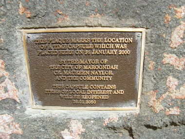
Photograph, The time capsule of the facsimile of the miner's hut, located at the back of Ringwood Lake, from the original that once stood on Maroondah Highway in the 1870s onwards. The capsule will be reopened on 28 January 2050. The cottage was erected by the Ringwood City Council in conjunction with Ringwood Historical Research Group (now Ringwood & District Historical Society). Officially opened by Mayor Cr Pat Gotlib JP on 29th May 1983
Photographic record by Russ Haines, RDHS, in October 2008. -
 Ringwood and District Historical Society
Photograph, Corner of Railway Place and Maroondah Highway, Ringwood at the former entrance to the railway station, showing shops on the other side of the road (now REALM library)
Photographic record by Russ Haines, RDHS, in October 2008. -
 Ringwood and District Historical Society
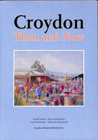
Book, Croydon Then and Now, 2012
Historic summary of Croydon comprised largely of early and contemporary photographs - Geoff Arnott, John Hutchinson, Les Hutchinson, Marjorie Meeuwsen, Croydon Historical Society Inc.Foreword by Cr. Les Willmott, J.P. - last mayor of the former City of Croydon. Acknowledgments: In the production of any book, many people play a part, be it financially or the giving of time with their knowledge and expertise in specialised areas, which concludes with a quality production - a book that is attractive, informative and accurate. We believe this book fits the description handsomely, and should bring joy and pleasant memories to many former and current residents of Croydon. To people who don't know very much about Croydon, this book will most certainly enlighten them. This has been a team effort, with many people playing important roles. With all this in mind, we would like to thank the following: The Maroondah City Council The Australian National Library Department of Families, Housing, Community Services and Indigenous Affairs Hutchinson Legal of Ringwood Sue Pitt, Alan Bennett and staff of the Croydon Library David and Ron Jewell Andrew Potts Adrian Arnott Elsie Bolwell Lyn Lynch Nick Anchen Cr Les Wilmott JP The Neville Family Bounty Print Dawn Gubb Photo courtesy of Leader Newspaper Press on pages 87, 90 and 113 -
 Ringwood and District Historical Society
Photograph, 12 Warrandyte Road, Ringwood. Now a car park for 10 Warrandyte Road 21 October 1992
Digital photograph -
 Eltham District Historical Society Inc
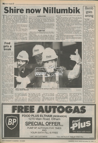
Newspaper - Newspaper article, Diamond Valley News, Shire now Nillumbik by Natalie Town, Diamond Valley News, November 23, p3, 1994
council amalgamation, shire of eltham, shire of montsalvat, shire of nillumbik, 1994, city of banyule, city of heidelberg, local government board, montsalvat, shire of diamond valley -
 Eltham District Historical Society Inc
Newsclipping, Eltham...then and now by Judy Lewis, Eltham Town Community News, date unk, pp10-11
Digital file only - Digitised by EDHS from a scrapbook on loan from Beryl Bradbury (nee Stokes), daughter of Frank Stokes.beryl bradbury (nee stokes) collection, eltham history -
 Eltham District Historical Society Inc
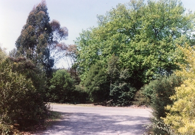
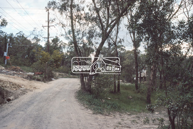
Slide, Reichelt Avenue, Montmorency at intersection with Bolton Street (now closed), c.Oct. 1980
One of a series of images of roads and infrastructure focussed on the Quinn Estate in Montmorency taken by Eltham Shire Council Planning and Engineering officers. They provide perspective of the changes in housing styles and road development that began sweeping in from the mid 1970s with increasing urbanisation of what was once more outlying suburbs and regions.35 mm colour positive transparency Mount - Kodak Kodachrome CardProcessed Oct 1980bolton steet, eltham, infrastructure, montmorency, reichelt avenue, roads -
 Eltham District Historical Society Inc
Newspaper clipping, Eltham War Memorial Trust: Ready Now for Forward Movement; Acknowledgements £722; publication unknown, c.1946, 1946c
Article about the purchase of land for the Eltham War Memorial and preparations to make a drive for funds History of the War Memorial Following the end of the First World War, communities across Victoria and Australia typically erected memorials which were predominantly statues, cenotaphs, avenues of honour and plaques. The Shire of Eltham established the Avenue of Honour at the gateway to the shire as well as an obelisk at the corner of Main Road and Bridge street and the Shire of Eltham War Memorial Tower at Kangaroo Ground. After the Second World War communities once again desired to preserve the memories of those who served and paid the ultimate sacrifice. Resources were scarce so there was a transition away from the traditional style memorials that sprang up post 1918 to one of building facilities that would provide ongoing benefit to the community. Even before the end of the Second World War, the citizens of Eltham began to consider an appropriate form of memorial for those from the area who fought and died in the First and Second World Wars. In 1943 the Eltham Women’s Auxiliary raised funds for the construction of buildings to be established on land to be purchased for the proposed War Memorial. On March 27th, 1945, the Eltham District Progress Association called a meeting of local people who in turn set up and registered the Eltham War Memorial Trust Inc. As a focus for the purpose of the memorial, the newspaper notice read:- ‘Those who have had a member of their family in the fighting services will want to see that the form of a memorial we are concerned with is the one which will be a constant reminder to us of those who fought for us and the little ones for whom they fought and died.’ At that meeting it was decided the Memorial should take the form of a baby health centre along with a creche and children’s library. In late 1945, the newly formed Eltham War Memorial Trust purchased the land at 903-907 Main Road Eltham from Miss Shillinglaw, which once formed part of the Shillinglaw farm on Lot 90 of Holloway’s 1851 “Little Eltham” subdivision. The Governor of Victoria, General Sir Dallas Brooks, laid the foundation stone on November 24th, 1950, in memory of those who fell in the Second World War. The Eltham Infant Welfare Centre was opened November 15th, 1952, the Pre-school on December 1st, 1956, and the Children’s Library in 1961. In late 1966 the children’s library service was integrated into the Heideberg Regional Library Service and the building was officially renamed the Eltham War Memorial Hall. Following the opening of the Eltham Infant Welfare Centre, work began in 1953 planning for the entrance to the grounds, which is signaled by a wrought iron arch entitled “Eltham War Memorial” . In 1954 the Eltham War Memorial Trust decided that a legacy provided by the late Councillor Ernest James Andrew (d. 29 March 1950) in memory of his wife, Mrs. Ellen Andrew (d. 13 July 1946) and who are both buried at Eltham Cemetery, should be used to fund the construction of the entrance. A metal plate inscribed to this effect was attached to the gates. Work on the Memorial Gardens was undertaken throughout the following decade, with a Memorial Forecourt included in the final 1956 plans for the Pre-School Centre. A quote was accepted by the Trust in 1963 for the implementation of a memorial garden, which included grading of a sixty-five foot strip at the rear of the Trust buildings and construction of concrete paths. The stone retaining walls at the front of the site were installed in 1968 when Main Road was widened and it is believed that the Memorial Gates were relocated at that time also. Eltham Senior Citizens Centre In 1964, Eltham Shire Council purchased a section of land from the Trust at the northern end of the site, as a provision for Country Fire Authority buildings. At the same time the Elderly Citizens Club proposed a Senior Citizens Centre on the south western section of the Trust’s property. This was approved by the Trust with the provision that the building was constructed in ‘accord’ with those already existing. In 1965 Council took on board the plans for the Senior Citizens Centre and applied for a government grant. These could only be awarded if Council owned the site. In 1962 the Trust had resolved to hand over the assets to Council once the Memorial Gardens were completed. This was in line with Health Department requirements that grants for the ongoing operation and maintenance of the three facilities would only be made once the the facilities were completed and handed over to Council. In 1965 the Department of Health further demanded substantial alterations to the Pre-School playground as a result of the pending impact of the planned Senior Citizens Centre and Main Road duplication. As a consequence, handover of the Trust’s assets to Council was initiated with a formal ceremony held in the Children’s Library on August 28th, 1965. The Trust continued on as a committee of management for another twelve months. Plans and specifications for the Senior Citizens Centre were prepared by March 1966. Council obtained a grant from the Government which covered one third of the cost and the building was completed by April 1967. Whilst the Senior Citizens Centre is contained within the original Eltham War Memorial building precinct, it was not part of the original Memorial and was not funded by the Eltham War Memorial Trust.Newsprint clippingeltham children's library, eltham infant welfare centre, eltham pre-school, eltham war memorial hall, eltham war memorial trust, women's auxiliary -
 Eltham District Historical Society Inc
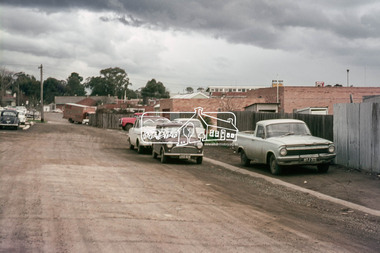
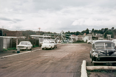
Photograph, Laneway running between Arthur Street and Luck Street (now Commercial Place), Eltham, c.6 May 1968, 1968
35mm Colour positive transparency Mount - Agfacolor Service (Blue stepped)arthur street, carparks, commercial place, eltham real estate, luck street, millets, pryor street, real estate agent, -
 Eltham District Historical Society Inc
Photograph, Laneway running between Arthur Street and Luck Street (now Commercial Place), Eltham, c.6 May 1968, 1968
35mm Colour positive transparency Mount - Agfacolor Service (Blue stepped)commercial place, luck street, pryor street -
 Eltham District Historical Society Inc
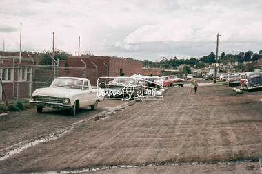
Photograph, Laneway running between Arthur Street and Luck Street (now Commercial Place), Eltham, c.6 May 1968, 1968
35mm Colour positive transparency Mount - Agfacolor Service (Blue stepped)carparks, commercial place, luck street, pryor street -
 Eltham District Historical Society Inc
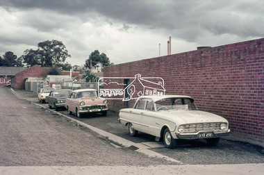
Photograph, Laneway running between Arthur Street and Luck Street (now Commercial Place), Eltham, c.6 May 1968, 1968
35mm Colour positive transparency Mount - Agfacolor Service (Blue stepped)arthur street, commercial place, eltham shire hall, pryor street -
 Federation University Historical Collection
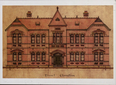
Plan - Postcard, Front Elevation of the Ballarat School of Mines New Classrooms (now Administration Building), 1898, 16/02/1899
In 1900 this building was described as 'handsome in design, well lit, well ventilated, commodious - containing Council room, office, chemical laboratory, mineralogical laboratory, students room and six lecture rooms. Postcard of the original hand coloured plan on linen of the Ballarat School of Mines New Classrooms (from 2014 known as the Federation University Australia SMB campus Administration Building). The plan shows the front elevation, section on line, ground and 1st floor plan. ballarat school of mines, new classrooms, administration building, architectural plans