Showing 15531 items matching "2016-01-30"
-
 Old Colonists' Association of Ballarat Inc.
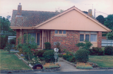
Photograph - Image, Clare Gervasoni, Ballarat Old Colonists' Association Residence - Permewan Cottage, 2016, 2016
... Ballarat Old Colonists' Association Residence - Permewan Cottage, 2016...(Revised Rules of the Old Colonists' Association of Ballarat Inc., 2016) ...2016...Ballarat Old Colonists' Association Residence - Permewan Cottage, 2016 Photograph Image Clare Gervasoni ...This cottage was completed in 1956. One of the first objectives of the Association was "to provide the shelter of a hose for those Pioneers of the Goldfields whom the reverses of fortune have deprived of the means of procuring the comforts of life in their declining years." The first home at Charles Anderson Grove was built in 1925. Before that time the Association provided relief for needy pioneers. relief included monthly monetary payments, loads of firewood, medical assistance and distribution of Christmas bosed of groceries to deserving pensioners, and in some cases payment of burial costs. ::a) The dominant purpose of the Association is to give public benevolent relief as a charity, but providing independent living accommodation in our Retirement Village for person in need who are over 65. ::b) To raise funds by membership subscription, commercial and residential rents, donations, gifts and voluntary work, for the purpose of providing direct relief of poverty, distress, misfortune or helplessness. ::c) To maintain the important heritage and ongoing viability of the Old Colonists' Association. (Revised Rules of the Old Colonists' Association of Ballarat Inc., 2016) Colour photograph of Permewan Cottage at The Old Colonists' Assiation of Ballarat Inc retirement village at Charles Anderson Grove, Ballarat.old colonists' association, ballarat, ballarat old colonists' club, charles anderson grove, permewan, permewan cottage, retirement village -
 Eltham District Historical Society Inc
Photograph, Buda, Castlemaine, Spring Gardens Excursion, 30 October 1988, 30 Oct 1988
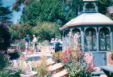
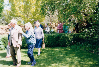
... Buda, Castlemaine, Spring Gardens Excursion, 30 October 1988...Pam and Marion EDHS Newsletter No. 62, September, 1988 SPRING GARDENS TRIP 30 Oct 1988 On this trip we will be visiting gardens which are of historic interest or of old world character. ...30 Oct 1988...Activities Eltham District Historical Society Buda Castlemaine Two colour photographic prints Buda, Castlemaine, Spring Gardens Excursion, 30 October 1988 Photograph ...Pam and Marion EDHS Newsletter No. 62, September, 1988 SPRING GARDENS TRIP 30 Oct 1988 On this trip we will be visiting gardens which are of historic interest or of old world character. The date has been selected to coincide with the time when the gardens are likely to be at their best. The Central Victorian Goldfields area has been selected because it offers a wide range of gardens open to the public. From this range we have chosen three gardens which we think will be of great interest to members and their families and friends. These are the gardens: • "Buda", Castlemaine One of Victoria's most famous historic gardens. The mansion which was the home of the Leviny family for 118~ years is also open for inspection. • "Badger's Keep", Chewton This is a cottage garden (complete with 100 year old cottage) with a great diversity of plants. • "The Springs", Sedgwick A country garden also with a great array of plants The cost of the bus is $9.00 for adults and $5.00 for children. There is an additional charge for entry to the gardens, $2.00 each for "Badger's Keep" and "The Springs": for "Buda" it is $3.00, $1.50 for pensioners and $1.00 for children Each of the gardens has plants for sale. Bring your own picnic lunch. Please be at the Eltham Shire Offices by 8.15 a.m. so we can leave promptly at 8.30. To book for this trip complete the attached form and return the appropriate fare. EDHS Newsletter No. 63, November, 1988 RECENT ACTIVITIES More recently the Spring Gardens trip attracted a full bus load and a waiting list. Those who went thoroughly enjoyed the historic garden and mansion at "Buda" and two other excellent gardens at "Badger's Keep" and "The Springs". The popularity of this trip warrants a repeat performance. There are a number of other gardens of historic and general interest which are worth a visit in the future.Two colour photographic printsactivities, eltham district historical society, buda, castlemaine -
 Eltham District Historical Society Inc
Photograph, Buda, Castlemaine, Spring Gardens Excursion, 30 October 1988, 30 Oct 1988
... Buda, Castlemaine, Spring Gardens Excursion, 30 October 1988...Pam and Marion EDHS Newsletter No. 62, September, 1988 SPRING GARDENS TRIP 30 Oct 1988 On this trip we will be visiting gardens which are of historic interest or of old world character. ...30 Oct 1988...Eltham District Historical Society Inc 728 Main Rd Eltham melbourne Pam and Marion EDHS Newsletter No. 62, September, 1988 SPRING GARDENS TRIP 30 Oct 1988 On this trip we will be visiting gardens which are of historic interest or of old world character. ...Pam and Marion EDHS Newsletter No. 62, September, 1988 SPRING GARDENS TRIP 30 Oct 1988 On this trip we will be visiting gardens which are of historic interest or of old world character. The date has been selected to coincide with the time when the gardens are likely to be at their best. The Central Victorian Goldfields area has been selected because it offers a wide range of gardens open to the public. From this range we have chosen three gardens which we think will be of great interest to members and their families and friends. These are the gardens: • "Buda", Castlemaine One of Victoria's most famous historic gardens. The mansion which was the home of the Leviny family for 118~ years is also open for inspection. • "Badger's Keep", Chewton This is a cottage garden (complete with 100 year old cottage) with a great diversity of plants. • "The Springs", Sedgwick A country garden also with a great array of plants The cost of the bus is $9.00 for adults and $5.00 for children. There is an additional charge for entry to the gardens, $2.00 each for "Badger's Keep" and "The Springs": for "Buda" it is $3.00, $1.50 for pensioners and $1.00 for children Each of the gardens has plants for sale. Bring your own picnic lunch. Please be at the Eltham Shire Offices by 8.15 a.m. so we can leave promptly at 8.30. To book for this trip complete the attached form and return the appropriate fare. EDHS Newsletter No. 63, November, 1988 RECENT ACTIVITIES More recently the Spring Gardens trip attracted a full bus load and a waiting list. Those who went thoroughly enjoyed the historic garden and mansion at "Buda" and two other excellent gardens at "Badger's Keep" and "The Springs". The popularity of this trip warrants a repeat performance. There are a number of other gardens of historic and general interest which are worth a visit in the future.Seven colour photographic printsactivities, eltham district historical society, buda, castlemaine -
 Eltham District Historical Society Inc
Photograph, Buda, Castlemaine, Spring Gardens Excursion, 30 October 1988, 30/10/1988
... Buda, Castlemaine, Spring Gardens Excursion, 30 October 1988...[from EDHS Newsletter No. 62, September 1988:] SPRING GARDENS TRIP 30 Oct 1988 On this trip we will be visiting gardens which are of historic interest or of old world character. ...30/10/1988...Eltham District Historical Society Inc 728 Main Rd Eltham melbourne [from EDHS Newsletter No. 62, September 1988:] SPRING GARDENS TRIP 30 Oct 1988 On this trip we will be visiting gardens which are of historic interest or of old world character. ...[from EDHS Newsletter No. 62, September 1988:] SPRING GARDENS TRIP 30 Oct 1988 On this trip we will be visiting gardens which are of historic interest or of old world character. The date has been selected to coincide with the time when the gardens are likely to be at their best. The Central Victorian Goldfields area has been selected because it offers a wide range of gardens open to the public. From this range we have chosen three gardens which we think will be of great interest to members and their families and friends. These are the gardens: • "Buda", Castlemaine: One of Victoria's most famous historic gardens. The mansion, which was the home of the Leviny family for 118~ years, is also open for inspection. • "Badger's Keep", Chewton: This is a cottage garden (complete with 100 year old cottage) with a great diversity of plants. • "The Springs", Sedgwick: A country garden also with a great array of plants. The cost of the bus is $9.00 for adults and $5.00 for children. There is an additional charge for entry to the gardens, $2.00 each for "Badger's Keep" and "The Springs"; for "Buda" it is $3.00, $1.50 for pensioners and $1.00 for children. Each of the gardens has plants for sale. Bring your own picnic lunch. Please be at the Eltham Shire Offices by 8.15 a.m. so we can leave promptly at 8.30. To book for this trip complete the attached form and return the appropriate fare. [from EDHS Newsletter No. 63, November 1988:] RECENT ACTIVITIES More recently the Spring Gardens trip attracted a full bus load and a waiting list. Those who went thoroughly enjoyed the historic garden and mansion at "Buda" and two other excellent gardens at "Badger's Keep" and "The Springs". The popularity of this trip warrants a repeat performance. There are a number of other gardens of historic and general interest which are worth a visit in the future.Two colour photographsactivities, buda, castlemaine -
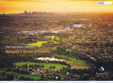 Greensborough Historical Society
Calendar, Banyule City Council, Banyule Community Calendar 2016: Banyule's great outdoors, 2016_
... Banyule Community Calendar 2016: Banyule's great outdoors....Each year it focusses on an aspect of the local community. The 2016 calendar contains photographs of local scenes and activities. ...Banyule Community Calendar 2016: Banyule's great outdoors. Calendar Banyule City Council ...This community calendar is distributed to residents of the City of Banyule each year. Each year it focusses on an aspect of the local community. The 2016 calendar contains photographs of local scenes and activities. Some council services are detailed in the back pages.The annual report is a record of the activities and services in the Banyule City Council area.28 pages. Colour illustrations. Illustrations of local scenes and landmarks.banyule city council, banyule community calendar -
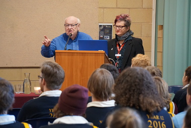 Galen Catholic College
Father Bob Maguire visits Galen Catholic College, 2016
... Father Bob Maguire visits Galen Catholic College, 2016....Father Bob spoke to our Year 12 students in 2016 in our auditorium. Father Bob Maguire is a well known priest, community worker and media personality from South Melbourne. ...Galen Catholic College Galen College VCE Year 12 Year 12 Students Auditorium Father Bob Maguire visits Galen Catholic College, 2016. Father Bob Maguire visits Galen Catholic College, 2016. ...Father Bob spoke to our Year 12 students in 2016 in our auditorium. Father Bob Maguire is a well known priest, community worker and media personality from South Melbourne. These photographs are a record of Father Bob's presentation. galen catholic college, galen college, vce, year 12, year 12 students, auditorium -
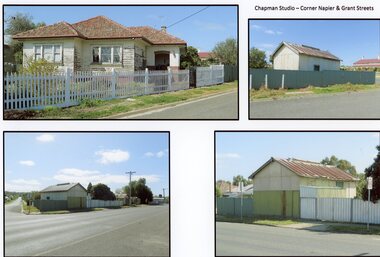 Stawell Historical Society Inc
Photograph, Mr W. J. Chapman -- Stawell Photographer's home on the corner of Maud and Grant Streets 2016
... Chapman -- Stawell Photographer's home on the corner of Maud and Grant Streets 2016...Photographic Studio back onto Grant Street. Photos Taken 2016....Photographic Studio back onto Grant Street. Photos Taken 2016. Stawell Business Mr W. J. Chapman -- Stawell Photographer's home on the corner of Maud and Grant Streets 2016 Photograph ...Home of W. J. Chapman Photographer of Stawell corner of Maud and Grant Streets. 8 Maud Street which later was renumbered 29 Grant Street. Photographic Studio back onto Grant Street. Photos Taken 2016.stawell business -
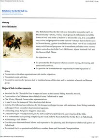 Kiewa Valley Historical Society
Printed material from the internet, with colour illustrations – History of the Birkebeiner Nordic Ski Club Inc, 14/01/2016
... Sourced from http://birkebeiner.org.au/about/history/, 14/01/2016 7.45pm...14/01/2016...Sourced from http://birkebeiner.org.au/about/history/, 14/01/2016 7.45pm Printed material from the internet, with colour illustrations – History of the Birkebeiner Nordic Ski Club Inc ...The Birkebeiner Nordic Ski Club was formed in September 1977 when a group of enthusiasts met to discuss the idea. The club, located in Mount Beauty has conducted many activities and programs for its members and other cross country skiers at the Falls Creek Ski Resort, Alpine National Park and the Bogong High Plains. Club objectives are to promote the development of cross country racing, ski touring and associated activities. To assist in searches for persons lost in bushland areas and to maintain a Search and Rescue group. It also provides its members with opportunities for skiing and social activities. The Birkebeiner Nordic Ski Club constructed a clubhouse at Falls Creek for the use of members in 1996. The club has conducted the annual Kangaroo Hoppet since 1991. Since its inception, the Birkebeiner Nordic Ski Club has been active in promoting cross country skiing including racing and touring in the Falls Creek, Alpine National Park and the Bogong High Plains areas and have actively participated in search and rescue in the alpine region. Birkebeiner members have represented Australia at five Olympic Games. A number of Kiewa Valley residents are active members or have been past members of the club over the years.Printed material from the internet with colour illustrations – History of the Birkebeiner Nordic Ski Club Inc. Sourced from http://birkebeiner.org.au/about/history/, 14/01/2016 7.45pmbirkebeiner ski club; nordic skiing; cross country skiing; falls creek; bogong high plains -
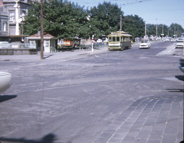 Ballarat Tramway Museum
Slide - 27 mm sq slide/s - set of 2, Andrew Howlett, tram 30 at the City terminus, Nov. 1969
... tram 30 at the City terminus...Colour slide, Kodak white cardboard mount, developed Nov 1969 of No. 30 at the City terminus and then crossing Lydiard St on its way to Victoria St. ...Ballarat Tramways trams Sturt St Lydiard St Town Hall tram 30 Colour slide, Kodak white cardboard mount, developed Nov 1969 of No. 30 at the City terminus and then crossing Lydiard St on its way to Victoria St. ...Yields information about the intersection of Lydiard St and Sturt St.Colour slide, Kodak white cardboard mount, developed Nov 1969 of No. 30 at the City terminus and then crossing Lydiard St on its way to Victoria St. In the background on .1 is the Santa Tram, No. 18. As well the shelter at the City tram terminus, the National Mutual building, the Town Hall, Georges Sea Food bar and V. F Gemmola Chemist.ballarat, tramways, trams, sturt st, lydiard st, town hall, tram 30 -
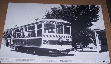 Ballarat Tramway Museum
Photograph - Illustration/s, Windsor Publications, Bendigo Birney 30
... Bendigo Birney 30...Large print illustration of SEC Bendigo Birney No. 30 ex depot running out to the Railway station on a Sunday prior to running to Eaglehawk. ...Printed on heavy cardboard with a gloss sheet. Bendigo Birney 30 Photograph Illustration/s Windsor Publications ...Large print illustration of SEC Bendigo Birney No. 30 ex depot running out to the Railway station on a Sunday prior to running to Eaglehawk. No. 8 of a series of illustrations. Caption notes that Birney's no longer do this job - photo possible mid to late 1960's. Photo Windsor Publications. Two copies held. Printed on heavy cardboard with a gloss sheet.On rear of copy 1, letters "TBT"trams, tramways, birney, bendigo, windsor publications -
![Newspaper Clipping, Pride of the nation. Australia Day honours [2016], 27/01/2016](/media/collectors/4f729f5697f83e03086015b8/items/57d27d8bd0cdd11f0cf295ab/item-media/57d27f47d0cdd11f0cf39dfe/item-fit-380x285.jpg?cb=6) Greensborough Historical Society
Greensborough Historical SocietyNewspaper Clipping, Pride of the nation. Australia Day honours [2016], 27/01/2016
... Australia Day honours [2016]...27/01/2016 ...Australia Day honours [2016] Newspaper Clipping ...Retired Melbourne Fire Brigade Superintendent John Berry from Lower Plenty, received a Medal of the Order of Australia for his work. Nillumbik Council Australia Day Citizen of the Year was awarded to Eltham local Beth Pender for contributions to the community and various causes.News clipping, black text, colour image.australia day awards, john berry, beth pender -
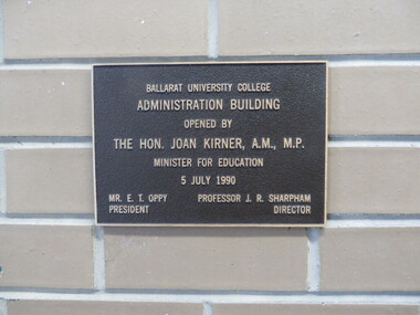 Federation University Historical Collection
Photograph, Clare Gervasoni, Federation University Mount Helen Administration Building Opening Plaque, 2016, 08/01/2016
... Federation University Mount Helen Administration Building Opening Plaque, 2016...08/01/2016...Federation University Mount Helen Administration Building Opening Plaque, 2016 Photograph Photograph Clare Gervasoni ....1) Photograph of the plaque put into position in the Federation University Mount Helen Campus Administration Building when opened by the Hon. Joan Kirner, A.M., M.P., Minister for Education, on 05 July 1990. .2) The plaque in situ in the opening of the Federation University Mount Helen Campus Administration Building. federation university, mount helen campus, administration building, buildings, plaque, joan kirner, visitor, john sharpham, e.t. oppy -
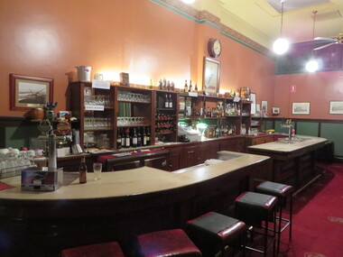 Old Colonists' Association of Ballarat Inc.
Photograph - Photograph - Colour, Clare Gervasoni, Bar at the Ballarat Old Colonists' Club, 2016, 01/07/2016
... Bar at the Ballarat Old Colonists' Club, 2016...01/07/2016...Bar at the Ballarat Old Colonists' Club, 2016 Photograph Photograph - Colour Clare Gervasoni ...Colour photograph of the bar in the Old Colonists' Hall. ballarat old colonists' club, bar, old colonists' hall -
 Ballarat Heritage Services
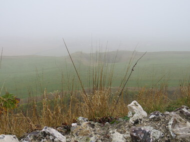
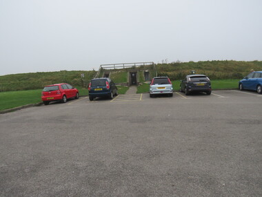
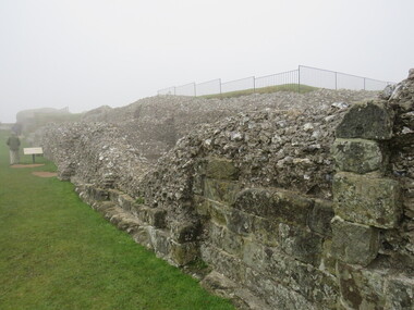
Photograph - Colour, looking from Stonework towards earth mounds, Old Sarum, England, English Heritage Site, 2016, 01 November 2016
... looking from Stonework towards earth mounds, Old Sarum, England, English Heritage Site, 2016...01 November 2016...The nearer end of Mudge's line is marked by an inscribed stone beside the modern A345 at Old Sarum. ordnance survey, william mudge, jesse ramsden, william the conqueror, old sarum, saxon, 1086, england looking from Stonework towards earth mounds, Old Sarum, England, English Heritage Site, 2016 Photograph - Colour ...William the Conqueror inherited Old Sarum from the last Saxon king of England. It was an ideal site for a royal castle. It was here in 1070 that William paid off his army after a long and bitter campaign in northern England. It was here in 1086 that he called together all the major landholders in England so they could swear allegiance to him. It was a crucial moment. The Domesday Book was being written, a threatened Viking invasion had only just been averted and William's eldest son was in armed rebellion. Old Sarum was an important place where this Norman king of England held power. In 1794 the Ordnance Survey set out to check the accuracy of the first mapping of Southern England, which had begun ten years earlier. From a point just below Old Sarum Lieutenant William Mudge laid out a base-line 36,574 feet (11,253 metres) long. From each end of the line the positions of distant places were plotted using a huge theodolite made in 1791 by Jesse Ramsden. The accuracy of the process, which was repeated all over England, depended on Jesse Ramsden's craftsmanship and on William Mudge's surveying skill in setting out this first base-line from Old Sarum. The nearer end of Mudge's line is marked by an inscribed stone beside the modern A345 at Old Sarum. ordnance survey, william mudge, jesse ramsden, william the conqueror, old sarum, saxon, 1086, england -
 Ballarat Heritage Services
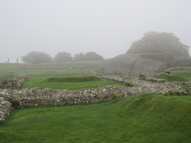
Photograph - Colour, Looking from Stonework towards people walking on earth mounds, Old Sarum, England, English Heritage Site, 2016, 01 November 2016
... Looking from Stonework towards people walking on earth mounds, Old Sarum, England, English Heritage Site, 2016...01 November 2016...The nearer end of Mudge's line is marked by an inscribed stone beside the modern A345 at Old Sarum. ordnance survey, william mudge, jesse ramsden, william the conqueror, old sarum, saxon, 1086, england Looking from Stonework towards people walking on earth mounds, Old Sarum, England, English Heritage Site, 2016 Photograph - Colour ...William the Conqueror inherited Old Sarum from the last Saxon king of England. It was an ideal site for a royal castle. It was here in 1070 that William paid off his army after a long and bitter campaign in northern England. It was here in 1086 that he called together all the major landholders in England so they could swear allegiance to him. It was a crucial moment. The Domesday Book was being written, a threatened Viking invasion had only just been averted and William's eldest son was in armed rebellion. Old Sarum was an important place where this Norman king of England held power. In 1794 the Ordnance Survey set out to check the accuracy of the first mapping of Southern England, which had begun ten years earlier. From a point just below Old Sarum Lieutenant William Mudge laid out a base-line 36,574 feet (11,253 metres) long. From each end of the line the positions of distant places were plotted using a huge theodolite made in 1791 by Jesse Ramsden. The accuracy of the process, which was repeated all over England, depended on Jesse Ramsden's craftsmanship and on William Mudge's surveying skill in setting out this first base-line from Old Sarum. The nearer end of Mudge's line is marked by an inscribed stone beside the modern A345 at Old Sarum. ordnance survey, william mudge, jesse ramsden, william the conqueror, old sarum, saxon, 1086, england -
 Ballarat Heritage Services
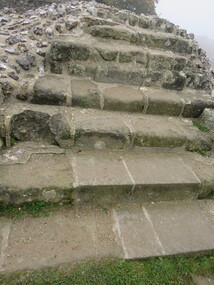
Photograph - Colour, Stairs, Old Sarum, England, English Heritage Site, 2016, 01 November 2016
... Stairs, Old Sarum, England, English Heritage Site, 2016...01 November 2016...The nearer end of Mudge's line is marked by an inscribed stone beside the modern A345 at Old Sarum. ordnance survey, william mudge, jesse ramsden, william the conqueror, old sarum, saxon, 1086, england Stairs, Old Sarum, England, English Heritage Site, 2016 Photograph - Colour ...William the Conqueror inherited Old Sarum from the last Saxon king of England. It was an ideal site for a royal castle. It was here in 1070 that William paid off his army after a long and bitter campaign in northern England. It was here in 1086 that he called together all the major landholders in England so they could swear allegiance to him. It was a crucial moment. The Domesday Book was being written, a threatened Viking invasion had only just been averted and William's eldest son was in armed rebellion. Old Sarum was an important place where this Norman king of England held power. In 1794 the Ordnance Survey set out to check the accuracy of the first mapping of Southern England, which had begun ten years earlier. From a point just below Old Sarum Lieutenant William Mudge laid out a base-line 36,574 feet (11,253 metres) long. From each end of the line the positions of distant places were plotted using a huge theodolite made in 1791 by Jesse Ramsden. The accuracy of the process, which was repeated all over England, depended on Jesse Ramsden's craftsmanship and on William Mudge's surveying skill in setting out this first base-line from Old Sarum. The nearer end of Mudge's line is marked by an inscribed stone beside the modern A345 at Old Sarum. ordnance survey, william mudge, jesse ramsden, william the conqueror, old sarum, saxon, 1086, england -
 Ballarat Heritage Services
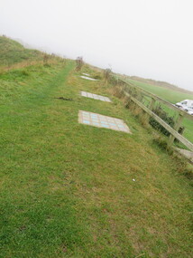
Photograph - Colour, Public toilets hidden in earth mound, Old Sarum, England, English Heritage Site, 2016, 01 November 2016
... Public toilets hidden in earth mound, Old Sarum, England, English Heritage Site, 2016...01 November 2016...The nearer end of Mudge's line is marked by an inscribed stone beside the modern A345 at Old Sarum. ordnance survey, william mudge, jesse ramsden, william the conqueror, old sarum, saxon, 1086, england Public toilets hidden in earth mound, Old Sarum, England, English Heritage Site, 2016 Photograph - Colour ...William the Conqueror inherited Old Sarum from the last Saxon king of England. It was an ideal site for a royal castle. It was here in 1070 that William paid off his army after a long and bitter campaign in northern England. It was here in 1086 that he called together all the major landholders in England so they could swear allegiance to him. It was a crucial moment. The Domesday Book was being written, a threatened Viking invasion had only just been averted and William's eldest son was in armed rebellion. Old Sarum was an important place where this Norman king of England held power. In 1794 the Ordnance Survey set out to check the accuracy of the first mapping of Southern England, which had begun ten years earlier. From a point just below Old Sarum Lieutenant William Mudge laid out a base-line 36,574 feet (11,253 metres) long. From each end of the line the positions of distant places were plotted using a huge theodolite made in 1791 by Jesse Ramsden. The accuracy of the process, which was repeated all over England, depended on Jesse Ramsden's craftsmanship and on William Mudge's surveying skill in setting out this first base-line from Old Sarum. The nearer end of Mudge's line is marked by an inscribed stone beside the modern A345 at Old Sarum. ordnance survey, william mudge, jesse ramsden, william the conqueror, old sarum, saxon, 1086, england -
 Ballarat Heritage Services
Photograph - Colour, Entrance to Public toilets hidden in earth mound, Old Sarum, England, English Heritage Site, 2016, 01 November 2016
... Entrance to Public toilets hidden in earth mound, Old Sarum, England, English Heritage Site, 2016...01 November 2016...The nearer end of Mudge's line is marked by an inscribed stone beside the modern A345 at Old Sarum. ordnance survey, william mudge, jesse ramsden, william the conqueror, old sarum, saxon, 1086, england Entrance to Public toilets hidden in earth mound, Old Sarum, England, English Heritage Site, 2016 Photograph - Colour ...William the Conqueror inherited Old Sarum from the last Saxon king of England. It was an ideal site for a royal castle. It was here in 1070 that William paid off his army after a long and bitter campaign in northern England. It was here in 1086 that he called together all the major landholders in England so they could swear allegiance to him. It was a crucial moment. The Domesday Book was being written, a threatened Viking invasion had only just been averted and William's eldest son was in armed rebellion. Old Sarum was an important place where this Norman king of England held power. In 1794 the Ordnance Survey set out to check the accuracy of the first mapping of Southern England, which had begun ten years earlier. From a point just below Old Sarum Lieutenant William Mudge laid out a base-line 36,574 feet (11,253 metres) long. From each end of the line the positions of distant places were plotted using a huge theodolite made in 1791 by Jesse Ramsden. The accuracy of the process, which was repeated all over England, depended on Jesse Ramsden's craftsmanship and on William Mudge's surveying skill in setting out this first base-line from Old Sarum. The nearer end of Mudge's line is marked by an inscribed stone beside the modern A345 at Old Sarum. ordnance survey, william mudge, jesse ramsden, william the conqueror, old sarum, saxon, 1086, england -
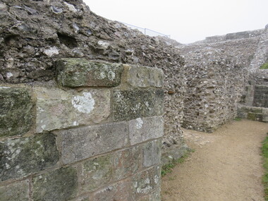 Ballarat Heritage Services
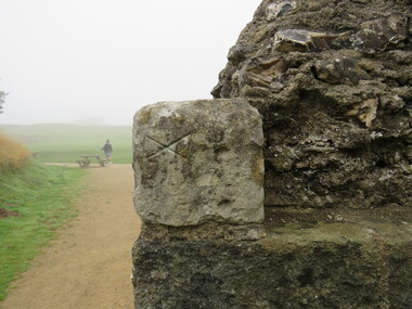
Photograph - Colour, Masons' Marks, Old Sarum, England, English Heritage Site, 2016, 01 November 2016
... Masons' Marks, Old Sarum, England, English Heritage Site, 2016...01 November 2016...The nearer end of Mudge's line is marked by an inscribed stone beside the modern A345 at Old Sarum. ordnance survey, william mudge, jesse ramsden, william the conqueror, old sarum, saxon, 1086, england Masons' Marks, Old Sarum, England, English Heritage Site, 2016 Photograph - Colour ...William the Conqueror inherited Old Sarum from the last Saxon king of England. It was an ideal site for a royal castle. It was here in 1070 that William paid off his army after a long and bitter campaign in northern England. It was here in 1086 that he called together all the major landholders in England so they could swear allegiance to him. It was a crucial moment. The Domesday Book was being written, a threatened Viking invasion had only just been averted and William's eldest son was in armed rebellion. Old Sarum was an important place where this Norman king of England held power. In 1794 the Ordnance Survey set out to check the accuracy of the first mapping of Southern England, which had begun ten years earlier. From a point just below Old Sarum Lieutenant William Mudge laid out a base-line 36,574 feet (11,253 metres) long. From each end of the line the positions of distant places were plotted using a huge theodolite made in 1791 by Jesse Ramsden. The accuracy of the process, which was repeated all over England, depended on Jesse Ramsden's craftsmanship and on William Mudge's surveying skill in setting out this first base-line from Old Sarum. The nearer end of Mudge's line is marked by an inscribed stone beside the modern A345 at Old Sarum. ordnance survey, william mudge, jesse ramsden, william the conqueror, old sarum, saxon, 1086, england -
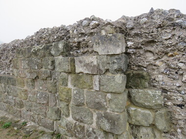 Ballarat Heritage Services
Photograph - Colour, Masons' Marks, Old Sarum, England, English Heritage Site, 2016, 01 November 2016
... Masons' Marks, Old Sarum, England, English Heritage Site, 2016...01 November 2016...The nearer end of Mudge's line is marked by an inscribed stone beside the modern A345 at Old Sarum. ordnance survey, william mudge, jesse ramsden, william the conqueror, old sarum, saxon, 1086, england Masons' Marks, Old Sarum, England, English Heritage Site, 2016 Photograph - Colour ...William the Conqueror inherited Old Sarum from the last Saxon king of England. It was an ideal site for a royal castle. It was here in 1070 that William paid off his army after a long and bitter campaign in northern England. It was here in 1086 that he called together all the major landholders in England so they could swear allegiance to him. It was a crucial moment. The Domesday Book was being written, a threatened Viking invasion had only just been averted and William's eldest son was in armed rebellion. Old Sarum was an important place where this Norman king of England held power. In 1794 the Ordnance Survey set out to check the accuracy of the first mapping of Southern England, which had begun ten years earlier. From a point just below Old Sarum Lieutenant William Mudge laid out a base-line 36,574 feet (11,253 metres) long. From each end of the line the positions of distant places were plotted using a huge theodolite made in 1791 by Jesse Ramsden. The accuracy of the process, which was repeated all over England, depended on Jesse Ramsden's craftsmanship and on William Mudge's surveying skill in setting out this first base-line from Old Sarum. The nearer end of Mudge's line is marked by an inscribed stone beside the modern A345 at Old Sarum. ordnance survey, william mudge, jesse ramsden, william the conqueror, old sarum, saxon, 1086, england -
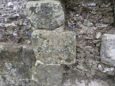 Ballarat Heritage Services
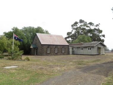
Photograph - Colour, Cressy Church, 2016, 26/01/2016
... Cressy Church, 2016...26/01/2016...Ballarat Heritage Services PO Box 2209 Bakery Hill Post Office goldfields Cressy Cressy Church, 2016 Photograph - Colour ...cressy -
 Ballarat Heritage Services
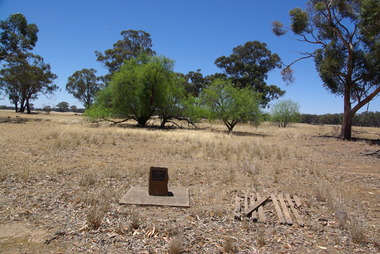
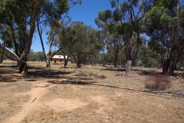
Photograph - School site, Site of the former Kurting State School, 2016, 10/01/2016
... Site of the former Kurting State School, 2016...10/01/2016...Site of the former Kurting State School, 2016 Photograph School site ...The Kurting State School No 2353 opened in 1881. The name changed to Hope Creek State School in 1893 and then in 1928 became the Powlett State School. The school burnt down in 1944 with school being held in the hall until the end of 1945. In 1946, the children of the area were bused to Inglewood. [Kurting - 808, Kurting - 2026 and Kurting - 2353]A plaque indicating the site of the Kurting Primary School. Site of Kurting State School N0. 2026 1878 - 1947 Project of Loddon Shire Council 2-4-2000kurting, kurting state school, kurting primary school -
 Ballarat Heritage Services
Photograph, Former Hogan Farm at Kurting, Victoria, 2016, 10/01/2016
... Former Hogan Farm at Kurting, Victoria, 2016...10/01/2016...Former Hogan Farm at Kurting, Victoria, 2016 Photograph Photograph ...John Hogan donated a part of his farm for the Kurting Mechanics' Institute Hall.Photographs of the former Hogan farm at Kurting, Victoria. The form was alongside the Kurting Hall.kurting, hogan -
 Ballarat Heritage Services
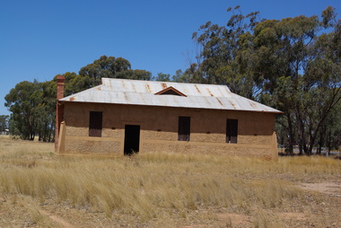
Photograph, Former Kurting Mechanics' Institute, Victoria, 2016, 10/01/2016
... Former Kurting Mechanics' Institute, Victoria, 2016...10/01/2016...Former Kurting Mechanics' Institute, Victoria, 2016 Photograph Photograph ...Kurting. Mechanics' Hall OFFICIAL OPENING. SUCCESSFUL FUNCTION. Favored by beautiful weather, the official opening ot the new Mechanics' Hall erected at Kurting proved an entire success. There was a large attendance ol local and district residents, and a sports meeting held during the afternoon in aid of Red Cross funds resulted in a substantial amount being netted. The hall, which stands on ground generously donated by Mr J. Hogan, between the school and the creek, is a substantialyvconcrete building of pleasing design, and was erected at a cost of about £330 by Mr J. H. Secombe, who also materially assisted the committee in the matter of finance. It is 48ft. long by 24ft. wide, with 12ft, walls, and should prove equal to the needs of the district for many years to come. It is well ventilated, and has large windows, these opening outwards on hinges. Doors at each side, and the back, as well as in front, give free means of access, while a fireplace in the back allows of provision being made for supper arrangements, water being laid on from a tank. Provi sion has been made for the partitioning off ot portion of the hall at any time this may be considered desirable. To provide a stage eight tables of a uniform size have been constructed to fit across the width of the hall. By these it will be possible, when euchre parties are being held, to use the full length of the hall. ... (Inglewod Advertiser, 19 July 1918) and also to convert tiie "stage" into card tables. The committee still has work ahead in the provision of a ceiling for the building and seating accomodation, but there is no doubt that the public support accorded them will be sufficient to enable these matters to be dealt with in the near future. A fine floor has been put down.Photographs of the former Kurting Hall, Victoria.kurting, kurting hall, john hogan, kurting mechanics' institute -
 Ballarat Heritage Services
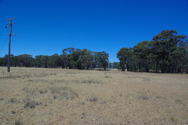
Photograph, Kurting, Victoria, 2016, 10/01/2016
... Kurting, Victoria, 2016...10/01/2016...Kurting, Victoria, 2016 Photograph Photograph ...Photographs of Kurting, in the former Kurting Hall, Victoria.kurting -
 Ballarat Heritage Services
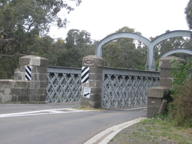
Photograph, Redesdale Bridge, 2016, 18/01/2016
... Redesdale Bridge, 2016...18/01/2016...Redesdale Bridge, 2016 Photograph Photograph ...The Redesdale Bridge is a wrought iron and timber structure with bluestone abutments which was installed over the Campaspe River in January 1868, although the bridge actually bears the date 1867. In 1859, the "Herald of the Morning", a ship carrying a cargo including 350 tons of ironwork for the Hawthorn bridge, caught fire and was scuttled a quarter of a mile off the jetty at Sandridge. A Melbourne salvaging firm raised the ironwork from the bottom of the bay, but after details of an arranged sale to the government caused a scandal in Parliament, the material was sold privately to the Melbourne foundry Langlands & Co. Two hundred tons of it was sold to the goldfields shires of McIvor and Metcalfe for only £1000. The bridge was designed by engineer T.B. Muntz and built by a contractor named Doran, and was completed late and considerably over budget at £6274. The bridge spans 45.7m across the river and has two roadways which are carried between three metal lattice girders in a through truss configuration. The design for the Hawthorn bridge had the deck supported over the trusses, and to stiffen the through truss configuration three sets of distinctive paired arches connect the trusses above the roadways. The roadway decking is constructed of longitudinally placed timbers on timber cross girders which rest on the lower chords of the trusses. (Heritage Victoria) A number of colour photographs showing the historic bridge at Metcalfe.metcalfe, shire of metcalfe, bridge, municipal boundary, shire of mcivor, redesdale bridge, campaspe river, t.b. muntz, doran -
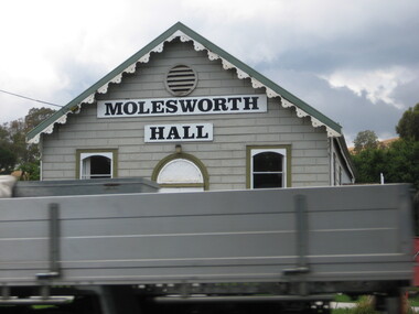 Ballarat Heritage Services
Photograph, Clare Gervasoni, Molesworth Hall, Victoria, 2016, 18/01/2016
... Molesworth Hall, Victoria, 2016...18/01/2016...Molesworth Hall, Victoria, 2016 Photograph Photograph Clare Gervasoni ...Colour photograph of the weatherboard Molesworth Hall. molesworth hall, molesworth