Showing 2588 items matching "aerial"
-
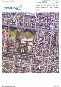 Greensborough Historical Society
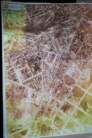
Photograph, Nearmap.com, Nearmap: Greensborough, 27/09/2012
Aerial photographs of the Watsonia area, land owned by Black and Families, including sites of Loyola College, Loyola Reserve and Gresswell ReserveFour coloured aerial photographswatsonia, black family, loyola college, gresswell forest reserve -
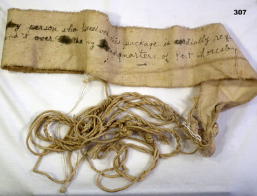 Bendigo Military Museum
Accessory - AERIAL STREAMER, 1942-45
Item collected By Ernest King NEWMAN VX100091 2nd AIF. Refer Cat No 317 for his service history.Aerial message , with string to be delivered from Japanese aircraft. Cloth is off-white."Any person who has received this package is cordially requested to send it over to the Army Headquarters of Port Moresby"streamers, communication, aerial -
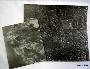 Bendigo Military Museum
Photograph - AERIAL PHOTOGRAPHS WW2, 1942 - 1944
Various reconnaissance photographs depicting targets in Timor for attack by the R.A.A.F. Items saved by Maurice Anthony BYRNE RAAF. Refer Cat No 215.9 for his service details.37 Aerial reconnaissance photographs of various locations over Timor and surrounding islands 1 Envelope: original container of photographs.Most images: Locations, including Latitude and Longitude marked on the backphotography-photographs-military, aerial -
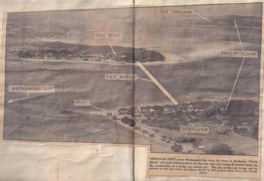 Phillip Island and District Historical Society Inc.
Newspaper clippings
Aerial photograph in newspaperAerial photograph of site of proposed bridge between San Remo and Newhaven.local history, documents, newspapers, bridges, phillip island, black & white newspaper clipping, phillip island. -
 Bendigo Historical Society Inc.
Map - BENDIGO MAP AERIAL VIEW, 1934
Map of Bendigo. Aerial View of Bendigo taken in 1934. Published by City of Great Bendigo.photograph, aerial, bendigo 1934 -
 National Wool Museum
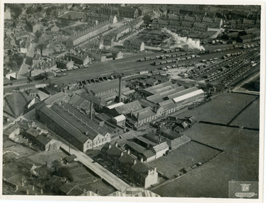
Photograph, Geographia Ltd, Unknown
Aerial photograph of a factory in the UK.Black and white aerial photograph of a factory with townhouses in the background in a landscape format.Front bottom right corner - Geographia Ltd, 167 Fleet Street, London, EC4. Back stamped - Neg. No. 3658 Date Subject Bides (?) 631wool, woollen mills, wool manufacture -
 Ballarat Heritage Services
Digital photographs, Werribee farm from the air, c2016
Aerial photograph of the Werribee Sewerage Farm, Victoria.werribee farm, mmbw, aerial, melbourne metropolitan board of works, sewerage -
 Greensborough Historical Society
Aerial Photograph, Flintoff land - View from above, 1945_
Section of the 1945 Greensborough aerial survey, focusing on the land belonging to the Flintoff familyPhotocopy of section of 1945 aerial survey of Greensborough area"Flintoff land to west of Diamond Creek Rd" written in pencil on backflintoff family, aerial photograph -
 Greensborough Historical Society
Aerial Photograph, AAM Photographics, Heidelberg AAM1969c 084, 24/11/1991
One of an overlapping series of aerial photographs of the Heidelberg/Greensborough areas, covering Greensborough, Macleod, Viewbank & Yallambie. North boundary Nell Street, South boundary Simpson BarracksLaminated colour aerial photographgreensborough, viewbank, yallambie -
 Tatura Irrigation & Wartime Camps Museum
Photograph, 1940
Camp 2 aerial photoBlack and white photograph of Camp 2 (aerial) channel left hand side.camp 2 aerial photo, italian pow camp -
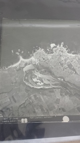
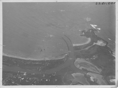 Port Fairy Historical Society Museum and Archives
Photograph, R.W.Golding, 1925
taken in 1925 by W Golding Aerial-Port Fairy Harbour 1925Black and White aerial view of Port Fairy ‘s waterways62.01.001 on front of photograph - on the back-Port Fairy Moyne River Entrance W Goldingaerial view, harbour, griffiths island, w.golding, training walls -
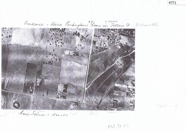 Greensborough Historical Society
Aerial Photograph, Watsonia North 1945, 1945_
Part of 1945 aerial survey, area of Watsonia North, including Grimshaw Street, Sellars Street and Macorna Street, indicating the home of Prudence and Maria Partington in Sellars Street.Photocopy of part 1945 aerial survey"Prudence and Maria Partington's home in Sellars St. Watsonia North"watsonia north, partington family -
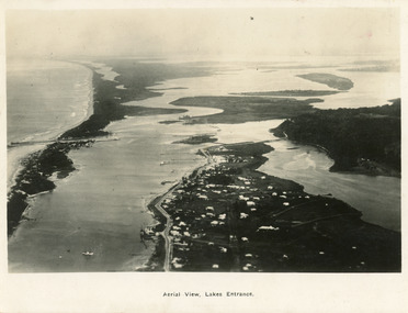 Lakes Entrance Historical Society
Postcard - Lakes Entrance, 1923c
Also large postcard 15 x 20|Also two mini postcard 6 x 9|Also copy black and white 9 x 14.5Black and white postcard of an aerial view of township of Lakes Entrance, showing western end of town, jetties and boat harbours in Cunninghame Arm, the entrance and piers, North Arm bridge, Bullock Island, Rigby, Fraser and Flannegan Islands, and a distant view of Boole Poole, Bunga Arm and Lake King. Lakes Entrance VictoriaAn aerial view showing position of Lakes Entranceaerial photograph, islands, waterways, topography, township -
 Greensborough Historical Society
Aerial Photograph, AAM Photographics, Heidelberg AAM1969c 086, 24/11/1991
One of a series of four overlapping aerial photographs of the Heidelberg/Greensborough areas in 1991, covering Simpson Barracks, Macleod, Rosanna, Viewbank, Watsonia & Yallambie. North boundary Yallambie Road; West boundary Hurstbridge railway.Laminated colour aerial photographssimpson barracks, yallambie, watsonia, macleod, rosanna, viewbank -
 Greensborough Historical Society
Aerial Photograph, AAM Photographics, Heidelberg AAM1969c 088, 24/11/1991
One of a series of overlapping aerial photographs of the Heidelberg/Greensborough area, covering Eaglemont, Heidelberg, Ivanhoe East & Viewbank. North boundary Hurstbridge railway, South boundary Ivanhoe East, East boundary Bulleen RoadLaminated colour aerial photographeaglemont, heidelberg, ivanhoe east, viewbank -
 Phillip Island and District Historical Society Inc.
Photograph - Post Card, 1954
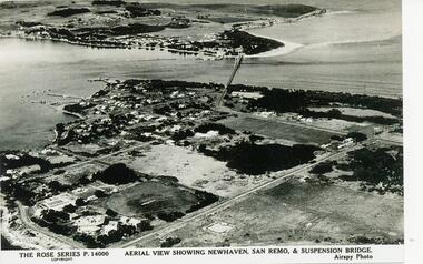
One of a collection of photographs donated by Daryl JohnsBlack & White photograph of aerial view over water and land. Newhaven in foreground and San Remo at rear of suspension bridge."The Rose Series P.14000. Aerial view showing Newhaven, San Remo & Suspension Bridge." Airspy Photo.phillip island, newhaven, san remo, daryl johns -
 Greensborough Historical Society
Aerial Photograph, AAM Photographics, Heidelberg AAM1969c 106, 24/11/1991
One of an overlapping series of aerial photographs of the Heidelberg/Greensborough areas in 1991, covering the Simpson Barracks, Greensborough & Viewbank. North boundary Nell Street, East boundary Plenty River, South boundary Lower Plenty Road.Laminated colour aerial photographsimpson barracks, greensborough, viewbank -
Clunes Museum
Photograph
Aerial coloured photo of Clunes, main buildings named and marked with yellow stickers, mines marked with white stickersaerial, clunes mines, john woodland collection -
 Lakes Entrance Historical Society
Photograph - Lakes Entrance, 1923c
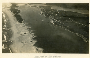
Two copies 16.5 x 25.5 very darkBlack and white photograph showing early aerial view of township of Lakes Entrance, photo shows highway going along Myer Street and along Roadknight Street, no shops in Myer Street appears to be no foot bridge, therefore taken prior to 1937, sparce vegetation on foreground dunes, four barriers built on dunes to stop erosion through sand, two masted sailing boat in lake. Bullock Island in distance appears very small, Snake Island of Rigby Island in centre distance. Lakes Entrance VictoriaAerial View of Lakes Entrancewaterways, coast, aerial photograph, islands, township -
Creswick Campus Historical Collection - University of Melbourne
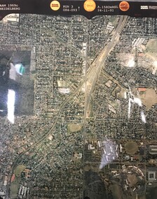
Still Image, 1952
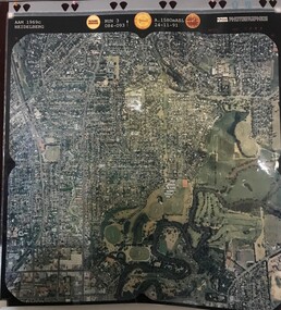
Subject: King Lake . 6 brown envelopes marked Run 3, 4, 7, 7a, 8, 9 containing c. 80 prints. 1 section of a topographical map marked State Aerial Survey. Stored in a brown cardboard file box marked King Lake Run No.3 - 9. (x9). Photos commissioned by Forests Commission Victoria.Aerial Photographs -
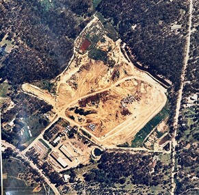 Greensborough Historical Society
Map - Aerial Photograph, Yarrambat, 04/11/1986
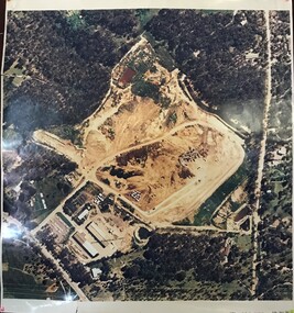
Colour aerial photograph of Diamond Valley Shire Depot, Yarrambat, now Nillumbik Shire Council Works Depot & Recycling CentreColour aerial photograph. Scale approx. 1:1000shire of diamond valley, yarrambat, nillumbik council -
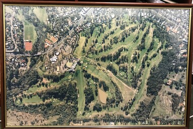
 Heidelberg Golf Club
Photograph - Framed Photograph, K. J. Kosnar, Heidelberg Golf Club: The new course, 1960s
An aerial photograph of the Heidelberg Golf Course, around late 1960s. Known as the 'new course' it was designed in 1968.One of several aerial photogrphs showing the layout of the Heidelberg Golf CourseLarge Black and white aerial photograph, metal frame with glass. heidelberg golf club, new course 1968 -
 Peterborough History Group
Photograph - Aerial Photograph Peterborough, Department of Crown Lands & Survey, Jan 1971
Aerial photograph showing the past layout of the townSignificant in that it shows the town as it was in 1971.Square 9" x 9" aerial photograph x 4 - (2 photos in duplicate)Stamped Dept of Crown Lands & Surveypeterborough 3270, curdies estuary, bay of islands, crown land photograph, aerial photograph, department of crown lands -
 Ballarat Heritage Services
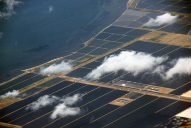
Digital Photograph, L.J. Gervasoni, werribee farm from the air, 2016
Digital Image showing an aerial view of the Melbourne Central Business District and Royal Park.aerial, melbourne, werribee farm, sewerage -
 Ballarat Heritage Services
Aerial digital photograph, L.J. Gervasoni, Mouth of the Yarra River and Westgate on approach to Melbourne's Tullamarine Airport, 2016
hoto taken from flight in to Melbourne International airport.Digital aerial image of Melbourne, Victoria.aerial, landscape, cityscape, mouth, yarra river, west gate bridge, aerial photograph -
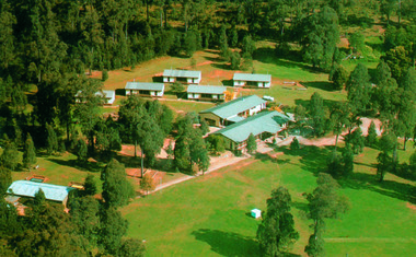 Marysville & District Historical Society
Photograph (Item) - Colour photograph, Unknown
A colour photograph of an aerial view of the lodges at the E.S.A. Camping and Conference Centre in Marysville.A colour photograph of an aerial view of the lodges at the E.S.A. Camping and Conference Centre in Marysville.marysville, victoria, australia, e.s.a. camping and conference centre, photograph -
 Heidelberg Golf Club
Photograph - Framed Photograph, Heidelberg Golf Club: The new course, 1980s
An aerial photograph of the Heidelberg Golf Course, around 1980s. Known as the 'new course' it was designed in 1968. This image shows the growth of treed areas around the course.One of several aerial photogrphs showing the layout of the Heidelberg Golf CourseLarge colour aerial photograph, timber frame with glass. heidelberg golf club, new course 1968 -
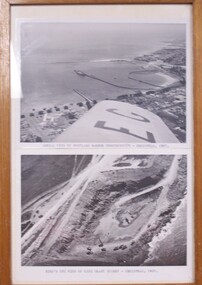 Glenelg Shire Council Cultural Collection
Photograph - Photographs - Aerial views of Portland and Cape Grant Quarry, 1957
Displayed in History House.Two photographs of aerial views in a wooden varnished frame.Front: Aerial view of Portland Harbour construction - Christmas 1957. (typed, under top image) Back: Bird's eye view of Cape Grant quarry - Christmas, 1957. (typed, under lower image)aerial photography, cape grant, portland harbour -
Whitehorse Historical Society Inc.
Article, Blackburn North, 2013
Real estate advertisement for former orchard block of land in Blackburn North.Real estate advertisement for former orchard block of land in Blackburn North. Agent: Woodards. Aerial photo.Real estate advertisement for former orchard block of land in Blackburn North. surrey road blackburn north, no. 59-67, cock, herbert, junction road blackburn north -
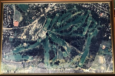
 Heidelberg Golf Club
Photograph - Framed Photograph, Heidelberg Golf Club: The new course, 1970s
An aerial photograph of the Heidelberg Golf Course, around late 1970s. Known as the 'new course' it was designed in 1968. This image shows the encroaching residential areas around the course.One of several aerial photogrphs showing the layout of the Heidelberg Golf CourseLarge colour aerial photograph, timber frame with glass. heidelberg golf club, new course 1968