Showing 15879 items
matching areas
-
 Flagstaff Hill Maritime Museum and Village
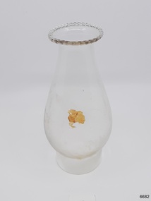
Domestic object - Lamp Glass, 1886-1908
The lamp glass was recovered from the wreck of the Falls of Halladale. It was blown into a mould, as evidenced by ripples in the base of the glass. The frosted inside area is likely to be from abrasive sediment inside the glass on the sea bed. The encrustations has also come from the sea. The Falls of Halladale was an iron-hulled, four-masted barque, used as a bulk carrier of general cargo. She left New York in August 1908 bound for Melbourne and Sydney. In her hold was general cargo consisting of roofing tiles, barb wire, stoves, oil, and benzene as well as many other manufactured items. After three months at sea and close to her destination, a navigational error caused the Falls of Halladale to be wrecked on a reef off the Peterborough headland on the 15th of November, 1908. The captain and 29 crew members survived, but her cargo was largely lost, despite two salvage attempts in 1908-09 and 1910. The Court of Marine Inquiry in Melbourne ruled that the foundering of the ship was entirely due to Captain David Wood Thomson's navigational error, not too technical failure of the Clyde-built ship. The Falls of Halladale was built in 1886 by Russell & Co., at Greenock shipyards on the River Clyde, Scotland for Wright, Breckenridge & Co of Glasgow. She was one of several designs of Falls Line of ships named after waterfalls in Scotland. The company had been founded between 1870- 1873 as a partnership between Joseph Russell, Anderson Rodger, and William Todd Lithgow. During the period 1882-92 Russell & Co. standardised designs, which sped up their building process so much that they were able to build 271 ships during that time. The Falls of Halladale had a sturdy construction built to carry maximum cargo and able to maintain full sail in heavy gales, one of the last of the 'windjammers' that sailed the Trade Route. She and her sister ship, the Falls of Garry, were the first ships in the world to include fore and aft lifting bridges. Previous to this, heavily loaded vessels could have heavy seas break along the full length of the deck, causing serious injury or even death to those on deck. The new, raised catwalk-type decking allowed the crew to move above the deck in stormy conditions. The Falls of Halladale shipwreck is listed on the Victorian Heritage (No. S255). She was one of the last ships to sail the Trade Routes from Europe and the Americas. Also of significance is that the vessel was one of the first ships to have fore and aft lifting bridges as a significant safety feature still in use on modern vessels today. The subject model is an example of an International Cargo Ship used during the 19th and early 20th centuries to transport goods around the world and representing aspects of Victoria’s shipping industry. Lamp glass, scalloped pattern around top lip, bulbous body. Slight encrustation on body. Glass has ripples in base area. Inside body is opaque in about a 1/5 ofr the area.flagstaff hill, warrnambool, flagstaff-hill, flagstaff-hill-maritime-museum, maritime-museum, shipwreck-coast, flagstaff-hill-maritime-village, falls of halladale, glass, russell & co., wreck, artifact, lamp glass, kerosene lamp, lighting -
 City of Kingston
Photograph - Black and white, 20 December 1945
This aerial photograph depicts the changing landscape of Cheltenham and Highett since WWII. Photographed in 1945, there is a mix of urban dwellings and industrial development and precedes the major transformation of Cheltenham with the development of the Southland shopping centre in the 1960s and expansion in the 1990s.A large part of Cheltenham was originally established as a rural market gardening community. The railway line and station brought urban development to the area and in the north, the Highett area was dominated by the Highett Gas Works. Cheltenham became a major destination for shopping in the 1960s with the opening of Southland.Aerial photograph taken in 1945 of Cheltenham and Highett within the City of Kingston. The image includes the Highett Reserve, (top right), the Methodist Children Homes (now Southland), Nepean Highway and Jamieson Street. Highett Gas Works is visible in the top left and the land now named William Fry Reserve at the intersection of Bay Road and Nepean Highway. A visible large parcel of land on the corner of Bay Road and Nepean Highway was developed in the 1990s as the west side addition to Southland. The densely vegetated area in the upper right sector of the image is now dense with housing. Tulip Grove, Heather Grove and Gilford Street are visible bottom left. This image is possibly from the collection of aerial photographs commissioned by the Department of Crown Lands and Survey and taken by Adastra Airways.Black ink: 57252 White lettering: VIC-10 57252 20.12.45 [lens information indecipherable] PROJ. No.5 MELB. METROP AREA Black pencil: 80highett, cheltenham, highett gas works, urbanisation -
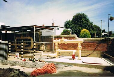
 Glenelg Shire Council Cultural Collection
Photograph - Photograph - Main Breakwater Construction, n.d
Port of Portland Authorityport of portland archives, portland harbour, work barge, wharf, construction, reclaimed area -
 Bendigo Historical Society Inc.
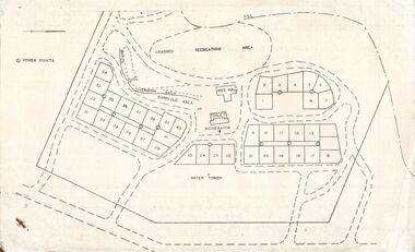
Document - STATE RIVERS AND WATER SUPPLY COMMISSION : EPPALOCK RECREATIONAL AREA PLAN?
Photocopied plan of power points for a recreational area, possibly Eppalock foreshore recreational area?. No title, and undated. With other Eppalock documents.state infrastructure, water supply, coliban system, state rivers and water supply commission. coliban system. eppalock. -
 Lakes Entrance Historical Society
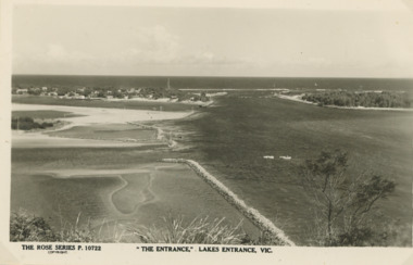
Postcard - Gippsland Lakes, Rose Stereograph Co Armidale Vic, The Entrance Lakes Entrance viewed from Jemmys Point, 1940 c
emmys Point showing the Entrance, groynes at the entrance to North Arm and around Bullock Island and portion of New Works area. Two small boats moored in main channel Lakes Entrance Victoria Black and white postcard taken from Jemmys Point showing the Entrance, groynes at the entrance to North Arm and around Bullock Island and portion of New Works area. Two small boats moored in main channel Lakes Entrance Victoria P10722The Entrance Lakes Entrance Victoria waterways, gippsland lakes, gippsland ports -
 Shepparton RSL Sub Branch
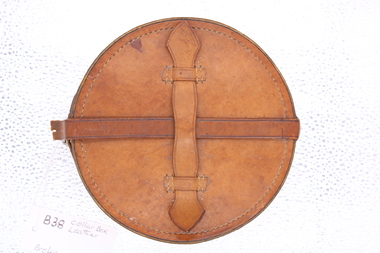
leather collar box, Round leather Collar Box
This collar box belonged to a soldier in WW2 who lived in the local Shepparton area. Round tan coloured leather case, lined with cream and brown stripped cotton material; a small leather carry strap with outer edges sewn either side to the top of case and a separate strap across the top of the case to fix the case closed with buckle feature; the closing strap is broken away from the buckle hole area.early - mid c20th collar box -
Glenelg Shire Council Cultural Collection
Photograph - Photograph - Pivot, Portland, n.d
Photograph of Pivot beach and area Portland.Back: Blue stamp - Portland Development Committee. 'The Phosphate Co-operative Co. Ltd. - manufacturers of superphosphate fertilizer' - grey lead.pivot, industry, harbour, fertiliser -
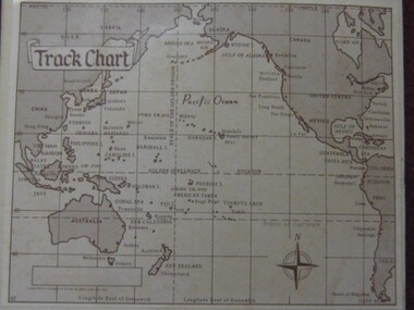 Running Rabbits Military Museum operated by the Upwey Belgrave RSL Sub Branch
Photo
Track Chart, Pacific Ops. Areaphoto, ww2, ran -
 Bendigo Historical Society Inc.
Photograph - CASTLEMAINE GAS COMPANY COLLECTION: PHOTO PIPES
Pipes and meters within a secure area.Kodakorganisation, industry, gas and fuel -
Bendigo Historical Society Inc.
Photograph - MINING
Mining . Bendigo Area. 40 Images. -
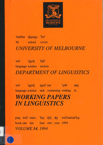 Victorian Aboriginal Corporation for Languages
Periodical, University of Melbourne Linguistics Section, Working papers in linguistics, 1994
A collection of papers on a variety of languages areas.linguistics -
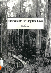 Victorian Aboriginal Corporation for Languages
Book, P D Gardner, Names around the Gippsland Lakes : their origins, meanings and history, 1991
Gives descriptions of area, origin and meanings.Maps, b&w illustrations, b&w photographsgippsland, gunnai, kurnai, bairnsdale, wurruk, place names -
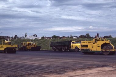 Stawell Historical Society Inc
Photograph - Slide, North Park Construction
Creating North Park Athletic ComplexYellow trucks and roller on graded area'North Park -
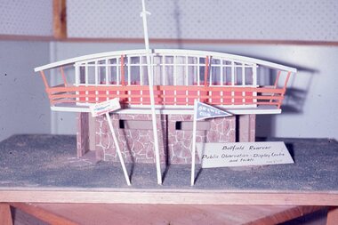 Stawell Historical Society Inc
Slide, Ian McCann, Constucting Lake Bellfield
Model of viewing area inc buildinglake bellfield -
 Stawell Historical Society Inc
Photograph, Stawell Gold Mine
Chilean Mill Julbilee Area 1973gold mining -
 Stawell Historical Society Inc
Photograph, Stawell Gold Mine
Chilean Mill Jubilee Area 1973gold mining -
 Stawell Historical Society Inc
Photograph, Stawell Gold Mine
Cyanide Vats Leviathan Area 1973gold mining -
Whitehorse Historical Society Inc.
Book, A History of Nunawading, 1972
A history of the area covered by the City of NunawadingA history of the area covered by the City of NunawadingA history of the area covered by the City of Nunawadingnunawading, blackburn, mitcham, vermont, burwood east, forest hill -
Whitehorse Historical Society Inc.
Pamphlet, The Whitehorse landscape as seen by the first settlers, 2011
Natural history of the Whitehorse area as at the 1830s.Natural history of the Whitehorse area as at the 1830s.Natural history of the Whitehorse area as at the 1830s.natural sciences, native plants, city of whitehorse -
Whitehorse Historical Society Inc.
Document, Mitcham Shopping Centre Improvement Scheme, c. 1973
Mitcham Shopping Area Development brief.Mitcham Shopping Area Development brief.Mitcham Shopping Area Development brief.mitcham shopping centre, development -
 Whitehorse Historical Society Inc.
Photograph, Barbecue in Complex, 1996
Coloured photo of Barbecue Area in Complexto be entered -
 Stawell Historical Society Inc
Memorabilia - Realia, Late 1800's
Relics from Goldfields in Stawell Areastawell -
Stawell Historical Society Inc
Archive, Glenorchy Pound & Stawell Shire Pound 1863 – 1867, 28/12/1863 - 1/10/1865 11/10/1865 - 25/11/1867
Large Volume covers two areasstawell, animals -
Stawell Historical Society Inc
Archive, Ararat/Great Western Pound 1863 – 1869, 19/9/1863 - 22/12/1869
Large Volume covers two areasstawell, animals -
 Stawell Historical Society Inc
Memorabilia - Realia, Late 1800's
Relics from Goldfields in Stawell Areastawell -
 Stawell Historical Society Inc
Memorabilia - Realia, Late 1800's
Relics from Goldfields in Stawell Areastawell -
University of Melbourne, Burnley Campus Archives
Photograph - Black and white print, 16. Bank of Hydrangea, 1925-1955
Bank of Hydrangea. On the edge of a grassed area.grassed area, hydrangea -
University of Melbourne, Burnley Campus Archives
Photograph - Black and white print, 491/10
Male on a tractor ploughing in Agrostology area.men, tractor, ploughing, agrostology, e. m. gibson collection -
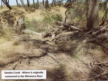 Stawell Historical Society Inc
Photograph, Swedes Creek where it originally connected to the Wimmera River 2017
Swedes Creek where it originally connected to the Wimmera River. 2017.Coloured photograph of a disturbed timber area.Swedes Creek - Where it originally connected to the Wimmera River.water -
 Linton and District Historical Society Inc
Photograph, Scotts, Sturt St, Ballarat, Devils Kitchen mine, 1920s
Sepia photograph of rugged mining area."Devils Kitchen 1920s".mines, devil's kitchen, piggoreet