Showing 1555 items
matching ballarat west
-
 Ballarat Heritage Services
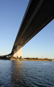
Digital photographs, L.J. Gervasoni, Under the west gate, c2016
yarra river, melbourne, west gate, west gate bridge, bridge -
 Ballarat Heritage Services
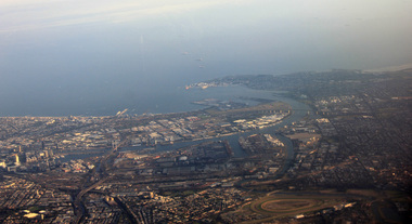
Aerial digital photograph, L.J. Gervasoni, Mouth of the Yarra River and Westgate on approach to Melbourne's Tullamarine Airport, 2016
hoto taken from flight in to Melbourne International airport.Digital aerial image of Melbourne, Victoria.aerial, landscape, cityscape, mouth, yarra river, west gate bridge, aerial photograph -
 Ballarat Heritage Services
Digital Photograph, L.J. Gervasoni, Melbourne CBD on approach Melbourne Airport, 2016, 2016
Digital Image showing the Melnourne Business District from the air.aerial, melbourne, mouth, yarra river, west gate bridge, inner west -
 Ballarat Heritage Services
Photograph, L.J. Gervasoni, Mouth of the Yarra River from the air, 2016
Digital Image showing an aerial view of the mouth of the Yarra River from the airaerial, melbourne, mouth, yarra, river, port phillip bay, flemington, docklands, bolte bridge, west gate bridge -
 Ballarat Heritage Services
Digital photographs, L.J. Gervasoni, Yarra River Melbourne Docklands Westgate Bridge, 2015
Digital Imagesyarra river melbourne docklands, yarra river, dock, docklands, shipping, port, channel, water, west gate bridge, bridge -
 Ballarat Heritage Services
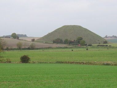
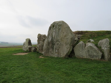
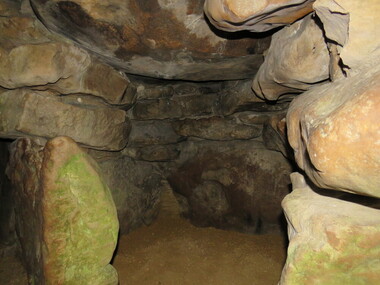
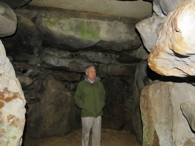
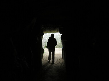
Photograph - Colour, Avebury World Heritage Site, Prehistoric Monuments, England, 2016
Colour photograph of the Silbury Hill, an immense Neolithic man-made mound part of the Avebury World Heritage Site. The Avebury World Heritage Site is a complex of outstanding prehistoric monuments comprising Windmill Hill (Early Neolithic enclosure and Bronze Age burial mounds); Silbury Hill; West Kennet Long Barrow; Avebury Stone Circles and West Kennet Avenue; The Sanctuary (site of stone and timber circles). It is part of National Trust and English Heritage. Visitors may walk to sites.avebury world heritage site, mound, prehistoric monuments, silbury hill, west kennet long barrow, neolithic, world heritage -
 Ballarat Heritage Services
Photograph - Colour, Silbury Hill, Avebury World Heritage Site, Prehistoric Monuments, England, 2016
Colour photograph of the Silbury Hill, an immense Neolithic man-made mound part of the Avebury World Heritage Site. The Avebury World Heritage Site is a complex of outstanding prehistoric monuments comprising Windmill Hill (Early Neolithic enclosure and Bronze Age burial mounds); Silbury Hill; West Kennet Long Barrow; Avebury Stone Circles and West Kennet Avenue; The Sanctuary (site of stone and timber circles). It is part of National Trust and English Heritage. Visitors may walk to sites.Colour photograph of rocks at Avebury World Heritage Site avebury world heritage site, prehistoric monuments, rocks -
 Ballarat Heritage Services
Photograph - Colour, Avebury World Heritage Site, Prehistoric Monuments, England, 2016
Colour photograph of the Silbury Hill, an immense Neolithic man-made mound part of the Avebury World Heritage Site. The Avebury World Heritage Site is a complex of outstanding prehistoric monuments comprising Windmill Hill (Early Neolithic enclosure and Bronze Age burial mounds); Silbury Hill; West Kennet Long Barrow; Avebury Stone Circles and West Kennet Avenue; The Sanctuary (site of stone and timber circles). It is part of National Trust and English Heritage. Visitors may walk to sites.Colour photograph of Avebury World Heritage Stte.avebury world heritage site, prehistoric monuments, rocks -
 Ballarat Heritage Services
Photograph - Colour, Silbury Hill, Avebury World Heritage Site, Prehistoric Monuments, England, 2016
Colour photograph of the Silbury Hill, an immense Neolithic man-made mound part of the Avebury World Heritage Site. The Avebury World Heritage Site is a complex of outstanding prehistoric monuments comprising Windmill Hill (Early Neolithic enclosure and Bronze Age burial mounds); Silbury Hill; West Kennet Long Barrow; Avebury Stone Circles and West Kennet Avenue; The Sanctuary (site of stone and timber circles). It is part of National Trust and English Heritage. Visitors may walk to sites.Colour photograph of Avebury World Heritage Site. avebury world heritage site, prehistoric monuments, rocks -
 Ballarat Heritage Services
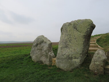
Photograph - Colour, Avebury World Heritage Site, Prehistoric Monuments, England, 2016
Colour photograph of the Silbury Hill, an immense Neolithic man-made mound part of the Avebury World Heritage Site. The Avebury World Heritage Site is a complex of outstanding prehistoric monuments comprising Windmill Hill (Early Neolithic enclosure and Bronze Age burial mounds); Silbury Hill; West Kennet Long Barrow; Avebury Stone Circles and West Kennet Avenue; The Sanctuary (site of stone and timber circles). It is part of National Trust and English Heritage. Visitors may walk to sites.Colour photograph of Avebury World Heritage Site. avebury world heritage site, prehistoric monuments, rocks -
 Ballarat Heritage Services
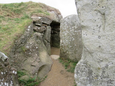
Photograph - Colour, Avebury World Heritage Site, Prehistoric Monuments, England, 2016
Colour photograph of the Silbury Hill, an immense Neolithic man-made mound part of the Avebury World Heritage Site. The Avebury World Heritage Site is a complex of outstanding prehistoric monuments comprising Windmill Hill (Early Neolithic enclosure and Bronze Age burial mounds); Silbury Hill; West Kennet Long Barrow; Avebury Stone Circles and West Kennet Avenue; The Sanctuary (site of stone and timber circles). It is part of National Trust and English Heritage. Visitors may walk to sites.Colour photograph of Avebury World Heritage Site.avebury world heritage site, rocks, prehistoric monuments -
 Ballarat Heritage Services
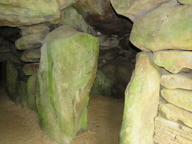
Photograph - Colour, Wayne Phillipson, Avebury World Heritage Site, Prehistoric Monuments, England, 2016
Colour photograph of the Silbury Hill, an immense Neolithic man-made mound part of the Avebury World Heritage Site. The Avebury World Heritage Site is a complex of outstanding prehistoric monuments comprising Windmill Hill (Early Neolithic enclosure and Bronze Age burial mounds); Silbury Hill; West Kennet Long Barrow; Avebury Stone Circles and West Kennet Avenue; The Sanctuary (site of stone and timber circles). It is part of National Trust and English Heritage. Visitors may walk to sites.Colour photograph of the Avebury World Heritage Site.prehistoric monuments, avebury world heritage site, rocks -
 Ballarat Heritage Services
Photograph - Colour, Wayne Phillipson, Avebury World Heritage Site, Prehistoric Monuments, England, 2016
Colour photograph of the Silbury Hill, an immense Neolithic man-made mound part of the Avebury World Heritage Site. The Avebury World Heritage Site is a complex of outstanding prehistoric monuments comprising Windmill Hill (Early Neolithic enclosure and Bronze Age burial mounds); Silbury Hill; West Kennet Long Barrow; Avebury Stone Circles and West Kennet Avenue; The Sanctuary (site of stone and timber circles). It is part of National Trust and English Heritage. Visitors may walk to sites.Colour photograph of Avebury World Heritage Site. avebury world heritage site, prehistoric monuments, rocks -
 Ballarat Heritage Services
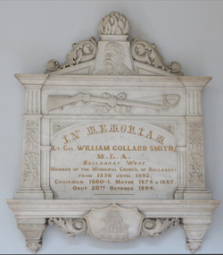
Photograph - Colour, William Collard Smith Memorial, Ballarat Town Hall, c1892, 15/09/2017
Photograph of a marble memorial in the Ballarat Town Hall dedicated to William Collard Smith.In Memoriam Lt. Col. William Collard Smith M.L.A. Ballaarat West Member of the Municipal Council of Ballaarat From 1856 until 1892 Chairmand 1860-1. Mayor 1874 and 1887 Obiit 20th Ovtober 1894.ballarat town hall, sculpture, coat of arms, duke of clarnence and avondale, william morris, rifles, city of ballarat coat of arms -
![Photograph - Colour, William Collard Smith Memorial, Ballarat Town Hall [detail], c1892, 15/09/2017](/media/collectors/57a00a4fd0cdd1210422a51e/items/59c8caaa21ea740dac0b5533/item-media/59c8cade21ea740dac0b6972/item-fit-380x285.jpg) Ballarat Heritage Services
Ballarat Heritage ServicesPhotograph - Colour, William Collard Smith Memorial, Ballarat Town Hall [detail], c1892, 15/09/2017
Photograph of the City of Ballarat Coat of Arms on a marble memorial in the Ballarat Town Hall dedicated to William Collard Smith.In Memoriam Lt. Col. William Collard Smith M.L.A. Ballaarat West Member of the Municipal Council of Ballaarat From 1856 until 1892 Chairmand 1860-1. Mayor 1874 and 1887 Obiit 20th Ovtober 1894.ballarat town hall, sculpture, coat of arms, duke of clarnence and avondale, william morris, rifles, city of ballarat coat of arms -
![Photograph - Colour, William Collard Smith Memorial, Ballarat Town Hall [detail], c1892, 15/09/2017](/media/collectors/57a00a4fd0cdd1210422a51e/items/59c8caf221ea740dac0b6d51/item-media/59c8cb0a21ea740dac0b7b59/item-fit-380x285.jpg) Ballarat Heritage Services
Ballarat Heritage ServicesPhotograph - Colour, William Collard Smith Memorial, Ballarat Town Hall [detail], c1892, 15/09/2017
Photograph of the City of Ballarat Coat of Arms on a marble memorial in the Ballarat Town Hall dedicated to William Collard Smith.In Memoriam Lt. Col. William Collard Smith M.L.A. Ballaarat West Member of the Municipal Council of Ballaarat From 1856 until 1892 Chairmand 1860-1. Mayor 1874 and 1887 Obiit 20th Ovtober 1894.ballarat town hall, sculpture, coat of arms, william morris, rifles, city of ballarat coat of arms, sword, volunteer rifles -
![Photograph - Colour, William Collard Smith Memorial, Ballarat Town Hall [detail], c1892, 15/09/2017](/media/collectors/57a00a4fd0cdd1210422a51e/items/59c8cbbf21ea740dac0bc27b/item-media/59c8cbd021ea740dac0bcbc6/item-fit-380x285.jpg) Ballarat Heritage Services
Ballarat Heritage ServicesPhotograph - Colour, William Collard Smith Memorial, Ballarat Town Hall [detail], c1892, 15/09/2017
Photograph of sculptural portrait of William Collard Smith on a marble memorial in the Ballarat Town Hall..In Memoriam Lt. Col. William Collard Smith M.L.A. Ballaarat West Member of the Municipal Council of Ballaarat From 1856 until 1892 Chairmand 1860-1. Mayor 1874 and 1887 Obiit 20th October 1894.ballarat town hall, sculpture, coat of arms, william morris, volunteer rifles -
 Ballarat Heritage Services
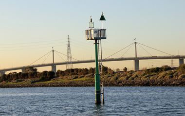
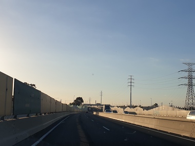
Photograph, Views of the Westgate Bridge, 29/11/2022
The Westgate Bridge spans the Yarra River giving access to Melbourne from the West. westgate bridge, melbourne, road, bridge -
 Ballarat Heritage Services
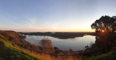
Photograph, Clare Gervasoni, Tower Hill Crater, 11/09/2020
Tower Hill is 18km west of Warrnambool and is accessed from the Princes Highway. Tower hill is a dormant volcano, with associated conical hills, large and small craters, basalt outcrops from lava flows and layers of Ash from long ago eruptions. Panorama of the crater at Tower Hilltower hill, crater, volcano -
 Ballarat Heritage Services
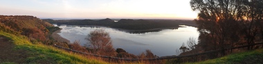
Photograph, Clare Gervasoni, Tower Hill Crater, 11/09/2020
Tower Hill is 18km west of Warrnambool and is accessed from the Princes Highway. Tower hill is a dormant volcano, with associated conical hills, large and small craters, basalt outcrops from lava flows and layers of Ash from long ago eruptions. Panorama of the crater at Tower Hilltower hill, crater, volcano -
 Ballarat Heritage Services
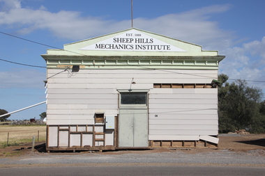
Photograph, Clare Gervasoni, Sheep Hills Mechanics' Institute, 08/10/2017
Sheep Hills is located Sheep Hills in the northern Wimmera region, north-west Victoria between Warracknabeal and Minyip.The Sheep Hills Mechanics' Institute was established in 1888.Weatherboard Mechanics' Institute at Sheep Hills Victoriasheep hills, sheep hills mechanics' institute -
 Ballarat Heritage Services
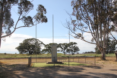
Photograph, Clare Gervasoni, Sheep Hills War Memorial, 2017, 08/10/2017
Sheep Hills is located Sheep Hills in the northern Wimmera region, north-west Victoria between Warracknabeal and Minyip.The Sheep Hills cenataph is opposite the Mechanics' Institute. The cenotaph commemorates those from the district who served in World Wars One and Two and lists the names of those who died in the conflict. Sheep Hills War Memorialsheep hills, sheep hills cenataph, sheep hills war memorial, allan albert, walter robert childs, joseph william darling, william pleass gove, george laing, herman percy robert schultz -
 Ballarat Heritage Services
Photograph - Digital photograph, Winter's Swamp surrounds, April 2014
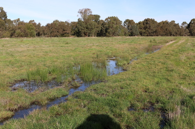
... was part of Ballarat West Common. The principle task ...The swamp was named after John (Jock) Winter. John Winter (Jock) was born in Berwickshire, Scotland. He married Janet Margaret Irving the daughter of Robert Irving, advocate, Bonshaw, Dumfries, Scotland. Winter died in Ballarat in 1875 and was buried at the Ballaarat Old Cemetery. He took up the run Bonshaw from 1841; Leigh River Buninyong 1842-46; Junction, Delatite, March 1851 to September 1862; with sons: Carag Carag and Corop, April 1857 to September 1872; Colbinabbin and Stewart’s Plains, April 1857 to December 1872; St Germains February 1867 to March 1871. (The name became Winter-Irving in 1890). Mr John Winter, who died on August 22 at the age of 72, was a man of some note it the mining community of Ballarat. He was a self-made man, and one of our oldest colonists, it being over a quarter of a century age since he took up county about Ballarat and settled at Bonshaw. He died very rich. It is calculated that if he had retained an interest in all his runs, his income must have been not less than £10,000 or £50,000 a year. Some eight or ten years ago he sold his Bonshaw pre-emption to the Bonshaw Gold mining Company for £20,000, and a few years later the ground belonging now to Winter's Freehold Company brought him £50,000 more, the payment being made at the requisition of the deceased in sovereigns. In these relations Mr. Winter has been closely identified with the mining industry at Ballarat. The deceased was a native of Lauder, in Berwickshire, and landed in Victoria several years before the gold discovery. BHS were commissioned by Ballarat Environment Network for a project on Winter's Swamp and Skipton Common. Winter's Swamp was part of Ballarat West Common. The principle task of this project was the delivery of a report outlining the history of European settlement in the Skipton and Cardigan/Ballarat districts as pertinent to the use of and impact on the natural environment of the two reserves Skipton Common and Winter Swamp. The report was delivered in digital form only. The report, upon completion, was presented to the Network’s Committee in order to discuss the project. The report identified and described the uses of Skipton Common and Winter Swamp, and their impacts. In particular, this report examined farming/grazing (official and informal), mining, vegetation removal (including the removal of woodlands for timber, grasslands for pasture improvement) & use of riparian areas for access to water and timber removal. Recording the more benign and environmentally friendly uses such as picnicking, community activities, nature walks and the roles of organisations such as Field Naturalists’ and Bird Observers’ clubs, school and scout/guide groups will be relevant in helping to depict overall community attitudes towards the reserves; e.g.: has the Common generally been viewed as little more than a grazing paddock and fire hazard; has Winter Swamp always been the unknown natural asset that seems to have been its lot for at least the past 40 years? In this regard, the more contemporary history of actions surrounding the use and management of the reserves is of particular interest, in view of the extant evidence at both reserves; e.g. the actions of the Shire of Ballarat in the 1980s in establishing Winter Swamp as something of a competitor to Lake Wendouree but with a more environmental bent (although almost none of the plants used are indigenous species, but that is part of the story); the trotting track constructed on Skipton Common in the 1960s following representations to Premier Henry Bolte and the cropping of the western section of the Common to raise funds for the town’s new swimming pool, the fertilizing of the land putting an end to the native grassland vegetation. There are obviously multiple sources of information to source in preparing the report, however sources that the contractor is specifically requested to consult are the Skipton Historical Society, the former Skipton Common managers (specifically Graeme Pett), the Cardigan Windermere Landcare Group and the Learmonth Historical Society (believed to hold many of the former Shire of Ballarat’s records pertaining to the Council’s role as the Committee of Management for both Winter Swamp and the Ballarat West Town Common – Winter Swamp was split between 2 separate Crown Land tenures). The contractor is also encouraged but not required to utilise community newsletters, such as the Skipton Community Newsletter, to publicise and seek information about the project. Skipton Historical Society (Mary Bradshaw) contacted on Thursday 12 June 2.30pm. Mary lived on a farm out of Skipton but is currently living in the township. She remembers walking along the creek of the Common especially in spring and autumn in bare feet and that it was a very pretty place. There were a few snakes around the waterway in summer. People put cows and a couple of horses on the commonage to graze. Graeme Pett has always lived close to the Common and would know a lot about it. Other possible contacts would be Nicole Petress, Secretary of the Progress Association, and the Corangamite Council, Camperdown. Mary can’t remember any photos in the Skipton Historical Society that pertain to the Common. Digital photos of Winter's swamp surrounds, later known as Mullawullah.winter, winter's swamp surrounds, winter's swap, john winter, ballarat environmental network, ballarat, mullawullah -
 Ballarat Heritage Services
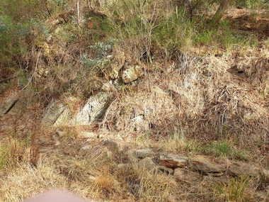
Photograph - Photograph - Colour, Anticline in the Hepburn Springs Reserve, 2019, 22/04/2019
Anticlines are folded rock formations that have an upwards convex shape. Anticlines can exist as a single fold or as a series of adjacent folds of alternating synclines and anticlines. The Hepburn Springs anticline is geologically associated with the west dipping fissures cutting across sandstone strata of the Hepburn Spring anticline.Colour photograph of an anticline at Hepburn Mineral Springs Reserve, in close proximity to the Sulphur Spring. hepburn springs, anticline, geology, hepburn mineral springs reserve, hepburn anticline, hepburn geology -
 Ballarat Heritage Services
Photograph - Colour, Clare Gervasoni, Fawcett Hall and Public Library, 2015, 11/01//2015
Fawcett Hall is 14 kilometres North West of Alexandra, North East Victoria, in Spring Creek Road and is set amongst a small picturesque rural farming and business community with hills as a backdrop and Stony Creek running alongside the public reserves property boundary. Part of our hall building dates back to its establishment in 1882. Originally the hall served as a Mechanics Institute and Public Library and later as a primary school.Colour photograph of a weatherboard Hall.fawcett hall and public library, fawcett, fawcett mechanics' institute -
 Ballarat Heritage Services
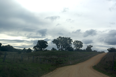
Photograph - Photograph - Colour, Clare Gervasoni, Tarilta, 2017, 16/07/2017
Tarilta is a rural locality and former gold-mining town 12 km south of Castlemaine, 4 km north-west of Guildford and 3 km north-east of Vaughan. The last gold mining activity took place around the 1880s. It was originally Kangaroo Flat, being located where the Kangaroo Creek enters the Loddon River. It was surveyed and named in 1864. Gold was discovered at Tarilta in 1853. The Tarilta School was opened in 1860 in a Wesleyan chapel, and closed i n1925. In 1864 a township was surveyed and named Tarilta, the word being derived from an Aboriginal expression thought to mean kangaroo. In 1865 Bailliere’s Victorian gazetteer described Tarilta as being an alluvial and quartz gold-mining town with three quartz-crushing mills, three horse-puddling machines and two hotels. The elevated nature of the land around Tarilta made it accessible only by horse and dray, or on horseback. Colour photograph of Tarilta in Central Victoria. tarilta, central victoria, landcape -
 Unions Ballarat
The Real War (Don Woodward Collection), Nixon, Richard M, 1981
Richard Nixon was President of the United States from 1969 until 1974 when he resigned (to avoid impeachment) over the Watergate scandal. The book is his account of East-West relations, arguing that the USA should be world leader to maintain peace. Nixon was succeeded by Gerald Ford who issued him with a pardon.US political and biographical relevance; international relations; international war and peace. Book; 366 pages. Front cover: author's name and title.btlc, ballarat trades hall, ballarat trades and labour council, presidents - united states, nixon, richard milhaus, politics and government, international relations, watergate, ford, gerald -
Unions Ballarat
Bob Carr: A self-made man, West, Andrew et al, 2003
Biography of Bob Carr. Bob Carr was Premier of NSW from 1995-2005 and subsequently a NSW Senator from 2012-2013. He served as Federal Foreign Minister. After leaving politics, he became an academic.Politics - ALP. Biographical interest.Book; 423 pages. Cover: blue background; colour picture of Bob Carr; blue lettering; authors' names and title. btlc, ballarat trades hall, ballarat trades and labour council, carr, bob, alp, australian labor party, biography, politics and government, politicians - premiers - nsw, cabinet ministers -
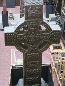 Ballarat Heritage Services
Digital Photograph, Dorothy Wickham, The Cast Courts, 2016, 09/2016
This ornate cross sits at the right hand side of View of Trajan's column, Cast Courts, Room 46a, The West Court, Victoria and Albert Museum, London. Cast Courts: "When the Architectural Courts – or Cast Courts as they are now known – opened in 1873, The Builder magazine compared the experience of seeing them to a first glimpse of Mont Blanc, creating one of those 'impressions that can scarcely be effaced'. Since then, these two enormous rooms and the reproductions they contain have continued to impress and inspire visitors to the Museum. For centuries, antiquarian interest in world architecture and sculpture led to reproductions – or copies – being made of outstanding national monuments and notable sculptures. When the Museum was founded, it collected and displayed reproductions of great art and architecture from across the world in order to offer objects for study and tell a complete story of the history of art and design. Casts are made by placing several plaster moulds upon the surface of the original structure. Once hardened and removed, the moulds are then enclosed in an outer casing, the interior coated with a separating agent and the wet plaster poured in. When set, the pieces are then assembled and the joints and surfaces finished off, to make a complete reproduction of the original work. The finished product – as well as being a formidable technical achievement in its own right – enables admirers to study faithful reproductions of important monuments and works of art." Ref: https://www.vam.ac.uk/articles/history-of-the-cast-courtslondon, victoria and albert museum, cast courts -
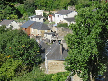 Ballarat Heritage Services
Digital Photograph, Dorothy Wickham, Vire, Normandie, France, 10/2016
The town of Vire is on a rocky promontory above the Vire River, situated in the south-west of the Calvados department of Lower Normandy, about half way between Caen (north-east of Vire) and Mont-Saint-Michel (to the south-west). Since 2016 the town has been part of the commune called Vire-Normandie. The town suffered quite heavily during bombardments at the end of the Second World War, and much reconstruction and renovation took place in the decade that followed the end of the war. (https://www.francethisway.com/places/vire.php) Julien Hardy, a stonemason and first discoverer of gold at Happy Valley, near Ballarat, Victoria Australia, was born near Vire, France. This photograph was taken by a descendant of Julian Hardy.Two colour photographs of buildings in the town of Vire, Normandie, France.julien hardy, vire, normandy