Showing 9209 items matching "bay"
-
 Warrnambool and District Historical Society Inc.
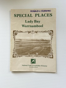
Pamphlet - Special Places Lady Bay Warrnambool, Philprint Warrnambool, 1989
This pamphlet was produced for the Warrnambool Branch of the National Trust of Australia (Victoria) for Heritage Week, April 16-23, 1989 and contains information written by Warrnambool residents about their locality. This was a co-operative venture by people with a common interest in protecting the natural environment near their home. Areas covered in the written information include: Formation of the Coast, Archaeological survey, Gunditjmara History, vegetation, history and recreational uses of the Lady Bay area. The map shows special places of interest including past and present navigational aids, sites of shipwrecks and other historical places of interest. The Warrnambool Branch of the National Trust was originally formed in March 1969 and merged with the Port Fairy Branch in late 1970. In October 1979, the Warrnambool Branch was reformed and operated into the late 1990's. This is an example of a publication produced by the Warrnambool Branch of the National Trust Australia (Victoria). It provides historical information and perspectives of the recreational uses in and around Lady Bay Warrnambool.An A2 piece of buff coloured thick paper folded into eight to make an A5 pamphlet. The front cover has green printing with the National Trust symbol of three eucalyptus leaves in green. There is a brown sepia photograph showing a view across Lady Bay with the suspension bridge across the Merri River in the foreground, Viaduct Road in the middle ground and the breakwater in the background. There is a purple inked stamp on the top right hand corner. The rear cover has brown writing and includes logos of bodies who assisted with the publication. There is a brown line drawing of the viaduct and pier at the Warrnambool Breakwater. The inside of the unfolded pamphlet contains a map of Lady Bay and adjacent area showing places of interest and shipwrecks marked in red circlesFront cover: Special Places Lady Bay Warrnambool National Trust of Australia (Victoria) Warrnambool Branch Ronald J. Cummingwarrnambool, lady bay warrnambool, national trust australia victoria warrnambool branch, heritage week 1989, lady bay shipwrecks -
 Flagstaff Hill Maritime Museum and Village
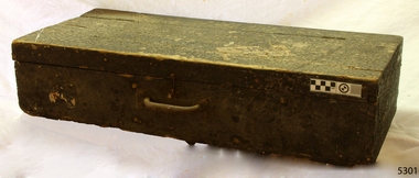
Equipment - Toolbox, ca. 1922
This toolbox was part of the equipment of the coastal trader Reginald M. It is typical of general-purpose toolboxes of the early 20th century. The covering of pitch on the outside was likely to be a form of waterproofing and protection. The vessel “Reginald M” was a two-masted coastal ketch, owned and built by Mr Jack (John) Murch of Birkenhead, Port of Adelaide, South Australia. Its construction took approximately 6 months and it was launched at Largs Bay in 1922. The vessel had many owners and adventures over the years until it was purchased by Flagstaff Hill Maritime Museum & Village in 1975. It was then used as an active display until 2016. Visitors could go aboard, turn the ship's wheel, go below deck and get the feel of the captain's quarters, sailors' quarters and the storage space available. The Reginald M was a popular exhibit for young and old, until 2016.This toolbox is significant because of its connection to the history of the vessel REGINALD M, the coastal trading ketch from South Australia built in 1922 and in existence until 2016. Its flat bottom, single-chine shape illustrates a very simple but robust method of construction, compared to other round-bilged examples of trading vessels. The Reginald M is listed on the Australian Register of Historic Vessels (ARHV Number: HV000562.) Wooden toolbox with hinged lid covering tree-quarters of the box. A case handle is attached for carrying. Hook on one side but nothing to catch it on. Toolbox has been covered with pitch on the outside. flagstaff hill, warrnambool, reginald m, flagstaff hill maritime museum & village, shipwreck coast, maritime museum, coastal trader, ketch, john murch, sailor's equipment, ship maintenance, wooden toolbox, toolbox -
 Lara RSL Sub Branch
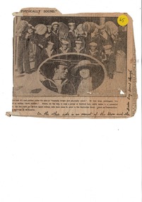
Newpaper article "Physically Sound", Argus newspaper article "Mentally Bright nd Phyically Sound" dated 16th June 1923
Circ 1923 historical information on the immigration to Australia.Part of an article from the The Argus Newspaper dated 16th June 1923 relating to the arrival of SS Moreton Bay and the British sailors due to enlist in the Australian Navy.Written on the article is a comment " On the other side is an account of the storm which the Moreton Bay passed through".the argus, ss moreton bay -
 Federation University Historical Collection
Document, Ken Clements, Peterborough Puzzles, 2009, 2009
Massacre Bay is located on Victoria's Great Ocean Road, and is in the centre of the Bay of Martyrs. The bay consists of 20 m high, red limestone bluffs. This paper by Ken Clements considers the origin of the term martyr in connection to this location, and where the Aboriginal massacre may have taken place. Thirteen page document by Ken Clements relating to Peterborough, Victoria. Contents include coastal features, local Aborigines, Bay of Martyrs, Massacre Bay, Massacre Hill, Buckley Creek Run, Pioneer Pastoralists, British Traversers, settlers, Peterborough, Maps, tourism, history method. Photographs by Laurie Moore.aborigines, bay of martyrs, massacre bay, massacre hill, buckley creek run, pioneer pastoralists, british traversers, settlers, peterborough, maps, tourism, history method, childers cove, barque children, murnane bay, sandy bay, dog trap bay, buckley creek, viviennes lookeout, stanhope bay, buttres bay, burnies beach, armstrong creek, flaxman hill, antares rock, lovers nook, crofts bay, clements, worm bay, halladale point, the well, wold dog cove, james irvine monument, curdies inlet, squirrel creek, wallaby creek, boggy creek, whiskey creek, pioneer beach, schomberg rock, young australia, spit, crown of thorns, newfield bay, the grotto, london bridge, point hesse, high cliffs, the arch, cape martyr, little massacre bay, aboriginal massacre, ken clements -
 Stawell Historical Society Inc
Book - History, Shipping Arrivals and Departures Vol 2 1846-1855
Dust Jacke Hardback: Blue background, white Print, Colour Print "View of Hobson's Bay by Captain Thomas RobertsonA Roebuck Book Shipping Arrivals and Departures Victorian Ports {Colour Print of Hobsons Bay} Volume 2 1846 - 1855 Marten A. Syme -
Port Melbourne Historical & Preservation Society
Map - Chart, Hobson's Bay, river and navigational aids, 1839 - 1843
On back is handwritten note - Hobson's Bay pp from HMS Beagle 1838-43.Map (Chart) of Hobson's Bay, River and Navigational Aids 1839. (Latrobe Library). in photographic form.melbourne harbor trust - port of melbourne authority, hobson's bay -
 Whitehorse Historical Society Inc.
Article, Orchard Grove Primary School, 02/12/2019
Orchard Grove Primary School.Orchard Grove Primary School is in need of an urgent revamp encompassing toilets, sick bay and staff facilities.Orchard Grove Primary School. orchard grove primary school no. 5285, education department -
Glenelg Shire Council Cultural Collection
Photograph - Photograph - Mac's Hotel, Portland, n.d
Black and white photo taken from Mac's Hotel, looking over the bay, Ocean Pier and Railway Pier, both with vessels berthed; Henty Beach with band rotunda; several people in period dress in foreground, near intersection of Bentinck and Cliff StreetsBack: 'Bay & Piers, Portland' - handwritten, black pen '15' - pencilportland harbour, macs hotel, vessel, cargo, celebration, recreation -
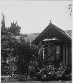 University of Melbourne, Burnley Campus Archives
Photograph - Black and white print, Principal's House, Unknown
Note by T.H. Kneen 8 April1992, "The bay window was replaced by a plain picture window in Mr. Jessep's time as Principal." (McLennan)Black and white photograph. View of bay window in the Principal's Residence and garden beds in front of it.bay window, a.w. jessep, principal's residence, principal's house, mclennan -
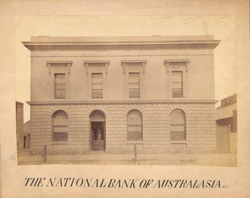 Port Melbourne Historical & Preservation Society
Photograph - Port Melbourne, The National Bank of Australasia, c 1890s
The National Bank of Australasia in Bay Street was designed by Leonard TERRY of Terry and Oakden, Architects and built in 1874. In 1889, architect George JOBBINS designed an extension of the southern end of the building. This photograph was taken after the alterations had been completed. A photograph of Bay Street by Charles NETTLETON from around 1878 (Cat No 178) shows the bank as it was originally built.Photograph of the facade of the National Bank of Australasia taken probably in the 1890s - Bay Street, Port MelbourneReceived from Port Melbourne Library 16/7/1973built environment - commercial, business and traders, national bank of australasia. -
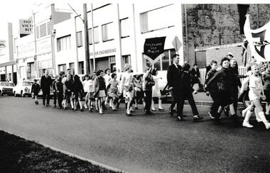 Port Melbourne Historical & Preservation Society
Photograph - Melbourne City Mission in procession down Bay Street, Reverend Donald LANGFORD, 1967
Group from the Melbourne City Mission in a procession down Bay Street, Port Melbourne. The Flower Hotel & Graham Engineering can be seen in the background.B & W photograph of group from the Melbourne City Mission in Bay Street parade.1967built environment - commercial, business and traders - hotels, business and traders - engineering, graham engineering, flower hotel, melbourne city mission -
Port Melbourne Historical & Preservation Society
Photograph - Prince Alfred Hotel, Bay Street, Port Melbourne, 1940 - 1941
Photo set in cardboard mount - of two customers and two bar staff at the bar of Prince Alfred Hotel, Bay Street 1940/41.On back in ink: Bar Prince Alfred Hotel/Bay St/Port Melbourne/1940-41/Joe Pettiona/Bill Jenkins/(nominee)business and traders - hotels, joe pettiona, william coy, bill jenkins, prince alfred hotel -
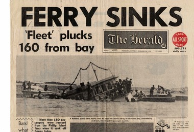 Phillip Island and District Historical Society Inc.
Newspaper, Eagle star ferry sinks, 30 December 1978
The Eagle Star left from Stony Point to take in Tankerton on the way to Cowes. It carried about 160 passengers of all ages, many of whom were probably planning to celebrate New Year’s Eve or start their holidays on the Island. The 48-year-old ferry had only recently been bought by a co-operative of French Island residents. Fortunately no one was drowned, and only two people were hurt.HistoricalBroadsheet front page from The Herald Saturday, December 30 1978.Headline is "Ferry sinks."Fleet" plucks 160 from bay" Large black and white photo showing half submerged ferry and three smaller motor boats pulling people from the water. other people are standing on the front of the ferry.Headline is "Ferry sinks."Fleet" plucks 160 from bay" ferries, eagle star, transport, cowes yacht club -
 Robin Boyd Foundation
Decorative object - Model of Pelican House, Davey's Bay Victoria, 2017
This scale model of the Robin Boyd-designed Pelican house, Davey's Bay Victoria, commissioned by Kenneth and Prue Myer in 1955. This house has been demolished. This model was created for the House of Ideas exhibition, made by a University of Melbourne, Melbourne School of Design, Masters student.Model of Pelican House, Davey's Bay in Mornington Peninsula, Victoriarobin boyd -
Port Melbourne Historical & Preservation Society
Letter - Con TALARICO to Cr Perce WHITE re formation of traders association for Bay Street, Aug 1982
This letter confirms that the initiative for formation of the Bay St Traders Association lay with Perce WHITELetter from Con TALARICO to Cr Perce WHITE concerning the formation of a traders association for Bay St, 1982business and traders, societies clubs unions and other organisations, con talarico, capace, bay street traders association, perce mcguire white, perce white, bay street -
Whitehorse Historical Society Inc.
Document, Shop and Park at Parkmore, 1963
An article about abundant parking at Brentford Square Shopping Centre, Parkmore. Which has 190 bays in addition to kerb parking.An article about abundant parking at Brentford Square Shopping Centre, Parkmore which has 190 bays in addition to kerb parking.An article about abundant parking at Brentford Square Shopping Centre, Parkmore. Which has 190 bays in addition to kerb parking.brentford square shopping centre forest hill, parking -
Port Melbourne Historical & Preservation Society
Photograph - Corner Bay and Bridge Streets, Port Melbourne, 1952
Stills from Glen Stuart's 1952 film 'Bay Street' taken when checking location of Mareborough shop.Colour photos of corner of Bay & Bridge Strret 1952, from 2 directions; stills from a film.built environment, glen stuart, bay street, bridge street -
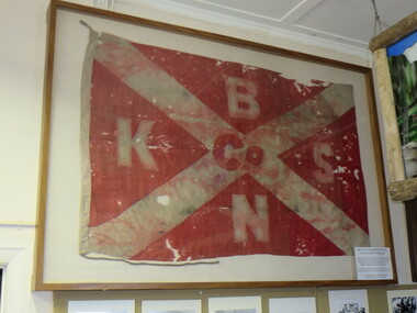 Apollo Bay Museum
BKSN Flag, The Belfast & Koroit Steam Navigation Company Flag
Recovered from the wreckage on the beach at Apollo Bay after the ss Casino was wrecked on 10th July 1932The Belfast & Koroit Steam Navigation Company flag recovered from the wreckage of the ss Casino at Apollo Bay in 1932B,K,S,N -
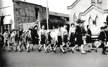
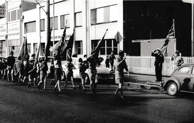 Port Melbourne Historical & Preservation Society
Photograph - Port Melbourne Scouts & Cubs in Bay Street Procession, Reverend Donald LANGFORD, 1967
Group from the Port Melbourne Scout & cub packs salute RAN officer & Scout leader in a procession down Bay Street, Port Melbourne. Graham Engineering can be seen in the background.B & W photograph of group of Port Melbourne Scouts & Cubs in Bay Street parade.1967built environment - commercial, business and traders - engineering, graham engineering, port melbourne scouts, cubs, armed services - navy -
Port Melbourne Historical & Preservation Society
Photograph - Melbourne City Mission, Jubilee Hall, Bay Street, Port Melbourne
Copied from Sister Norma Barnett's collection. Note Sr. Barnett's scooter in the foreground. Jubilee Hall was located behind the Fountain Inn, Bay to Crockford StreetsBlack and white lasercopy of photograph of the Melbourne City Mission at Jubilee Hall, Bay Street, c1960religion - melbourne city mission, sister norma jean barnett, jubilee hall -
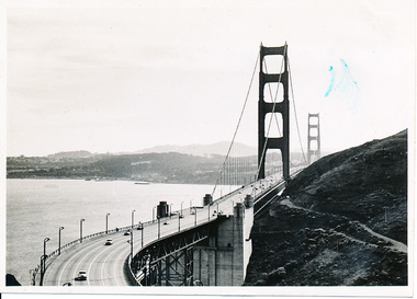 Mission to Seafarers Victoria
Photograph - Photograph, Black and white
This photograph is part of series depicting Allan Quinn's travels through San Francisco in 1949. This photograph shows the Golden Gate Bride and the San Francisco Bay.This is a photograph from the Allan Charles Quinn collection which is a collection of letters and photograph depicting aspects of life at sea for a young man in the era immediately following World War II.A black and white photograph of the Golden Gate Bridge, and the San Francisco Bay, dated 9-11-49.Reverse: 9-11-49 (handwritten in blue ink) / B /K8 (upside down, handwritten in pencil).allan-quinn, photograph, san-francisco, golden-gate-bridge, 1949, allan charles quinn (1928-1990) -
 Port Melbourne Historical & Preservation Society
Photograph - Port Melbourne Guides & Brownies in Bay Street Procession, Reverend Donald LANGFORD, 1967
Group from the Port Melbourne Guide & Brownie packs passes Holy Trinity Church, in procession down Bay Street, Port Melbourne..B & W photograph of group of Port Melbourne Guides & Brownies passing Holy Trinity Church in Bay Street.1967religion - anglican (holy trinity), girl guides, brownies -
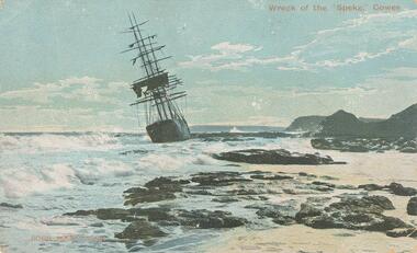 Phillip Island and District Historical Society Inc.
Photograph - Post Card, 1906
The "Speke" was a three masted steel ship built in Wales 1891 - the second largest at the time. The ship drifted broadside on to a reef to the east of Kitty Miller Bay on the 22nd February 1906 while on route from Peru via Sydney to Geelong in ballast to pick up wheat. Coloured postcard of the Wreck of the "Speke" near Kitty Miller Bay, Phillip Island.Wreck of the Speke," Cowes. Robb Bros. Cowes. On back: A letter from Miss Palmer's niece, Elsie with general family information. Sent on the 24/11/1907wreck of the speke, kitty miller bay phillip island, robb bros cowes phillip island, joan wilson -
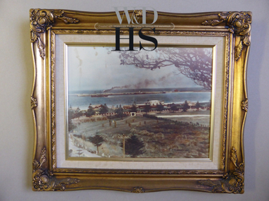 Warrnambool and District Historical Society Inc.
Print - Lady Bay & Jetty
This photograph shows Lady Bay and Lake Pertobe in the late 1930s or early 1940s. This is before Lake Pertobe was developed in the 1970s as a recreation area and when ships were still anchoring at the Breakwater. This is a print of a photograph and its interest lies only in the fact that it is nicely framed and is suitable for hanging. It shows the foreshore over 70 years ago so is of historical interest. This is a print of a colour photograph of Lake Pertobe and Lady Bay in a gilt-edged wooden frame with a linen cloth insert. On back of frame – ‘Frame -Right, 98 Fairy Street, Warrnambool 3280’ (telephone number not decipherable)warrnambool, lady bay -
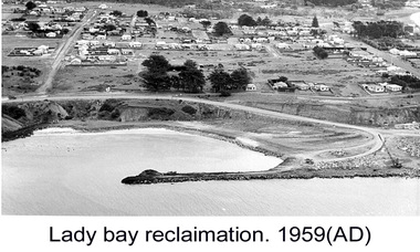 Glenelg Shire Council Cultural Collection
Photograph - Photograph - Lady Bay Reclamation: Aerial view looking West showing dumping of quarry overburden, 1959
Port of Portland Authority archivesFront: (no inscriptions) Back: 1959/ Lady Bay Reclamation/ Aerial view looking West showing dumping of/ Quarry overburden (black pen, upper left)port of portland archives, lady bay, reclamation, 1960s -
 Phillip Island and District Historical Society Inc.
Photograph, 1978/9
The Homestead was probably built about 1872 when Samuel Amess became the owner of Churchill Island. A large weatherboard construction with bay windows and corrugated iron roofing.Coloured photograph showing the homestead on Churchill Island. Bay windowed rooms projecting forward on either side of the verandah. Not the sundial in the foreground.local history, photographs, buildings - historical, rural industry, coloured photograph, john cook, churchill island -
 Flagstaff Hill Maritime Museum and Village
Decorative object - Wall Hanging, c. 1908
The unusual beautiful green American slate roofing tile used in this wall hanging was recovered from the shipwrecked Falls of Halladale. The iron-hulled, four-masted barque, the Falls of Halladale, was a bulk carrier of general cargo. She left New York in August 1908 on her way to Melbourne and Sydney. In her hold, along with 56,763 tiles of unusual beautiful green American slates (roofing tiles), 5,673 coils of barbed wire, 600 stoves, 500 sewing machines, 6500 gallons of oil, 14400 gallons of benzene, and many other manufactured items, were 117 cases of crockery and glassware. Three months later and close to her destination, a navigational error caused the Falls of Halladale to be wrecked on a reef off the Peterborough headland at 3 am on the morning of the 15th of November, 1908. The captain and 29 crew members all survived, but her valuable cargo was largely lost, despite two salvage attempts in 1908-09 and 1910. ABOUT THE ‘FALLS OF HALLADALE’ (1886 - 1908) Built: in1886 by Russell & Co., Greenock shipyards, River Clyde, Scotland, UK. The company was founded in 1870 (or 1873) as a partnership between Joseph Russell (1834-1917), Anderson Rodger and William Todd Lithgow. During the period 1882-92 Russell & Co., they standardised designs, which sped up their building process so much that they were able to build 271 ships over that time. In 1886 they introduced a 3000 ton class of sailing vessel with auxiliary engines and brace halyard winches. In 1890 they broke the world output record. Owner: Falls Line, Wright, Breakenridge & Co, 111 Union Street, Glasgow, Scotland. Configuration: Four masted sailing ship; iron-hulled barque; iron masts, wire rigging, fore & aft lifting bridges. Size: Length 83.87m x Breadth 12.6m x Depth 7.23m, Gross tonnage 2085 ton Wrecked: the night of 14th November 1908, Curdies Inlet, Peterborough south west Victoria Crew: 29 The Falls of Halladale was a four-masted sailing ship built-in 1886 in Glasgow, Scotland, for the long-distance cargo trade and was mostly used for Pacific grain trade. She was owned by Wright, Breakenridge & Co of Glasgow and was one of several Falls Line ships, all of which were named after waterfalls in Scotland. The lines flag was of red, blue and white vertical stripes. The Falls of Halladale had a sturdy construction built to carry maximum cargo and able to maintain full sail in heavy gales, one of the last of the ‘windjammers’ that sailed the Trade Route. She and her sister ship, the Falls of Garry, were the first ships in the world to include fore and aft lifting bridges. Previous to this, heavily loaded vessels could have heavy seas break along the full length of the deck, causing serious injury or even death to those on deck. The new, raised catwalk-type decking allowed the crew to move above the deck stormy conditions. This idea is still used today on the most modern tankers and cargo vessels and has proved to be an important step forward in the safety of men at sea. On 4th August 1908, with new sails, 29 crew, and 2800 tons of cargo, the Falls of Halladale left New York, bound for Melbourne and Sydney via the Cape of Good Hope. The cargo on board was valued at £35,000 and included 56,763 tiles of American slate roofing tiles (roof slates), 5,673 coils of barbed wire, 600 stoves, 500 sewing machines, 6,500 gallons of oil, 14,400 gallons of benzene, plumbing iron, 117 cases of crockery and glassware and many other manufactured items. The Falls of Halladale had been at sail for 102 days when, at 3 am on the night of 14th November 1908, under full sail in calm seas with a six knots breeze behind and misleading fog along the coast, the great vessel rose upon an ocean swell and settled on top of a submerged reef near Peterborough on south-west Victoria’s coast. The ship was jammed on the rocks and began filling with water. The crew launched the two lifeboats and all 29 crew landed safely on the beach over 4 miles away at the Bay of Islands. The postmistress at Peterborough, who kept a watch for vessels in distress, saw the stranding and sent out an alert to the local people. A rescue party went to the aid of the sailors and the Port Campbell rocket crew was dispatched, but the crew had all managed to reach shore safely by the time help arrived. The ship stayed in full sail on the rocky shelf for nearly two months, attracting hundreds of sightseers who watched her slowly disintegrate until the pounding seas and dynamiting by salvagers finally broke her back, and her remains disappeared back into deeper water. The valuable cargo was largely lost, despite two salvage attempts in 1908-09 and 1910. Further salvage operations were made from 1974-1986, during which time 22,000 slate tiles were recovered with the help of 14 oil drums to float them, plus personal artefacts, ship fittings, reams of paper and other items. The Court of Marine Inquiry in Melbourne ruled that the foundering of the ship was entirely due to Captain David Wood Thomson’s navigational error, not too technical failure of the Clyde-built ship. The shipwreck is a popular site for divers, about 300m offshore and in 3 – 15m of water. Some of the original cargo can be seen at the site, including pieces of roof slate and coils of barbed wire.The Falls of Halladale shipwreck is listed on the Victorian Heritage Register (No. S255). She was one of the last ships to sail the Trade Routes. She is one of the first vessels to have fore and aft lifting bridges. The Falls of Halladale is an example of the remains of an International Cargo Ship and also represents aspects of Victoria’s shipping industry. The wreck is protected as a Historic Shipwreck under the Commonwealth Historic Shipwrecks Act (1976).Wall hanging, framed slate salvaged from the wreck of Falls of Halladale. Slate is visible from both sides of TIMBER frame through glass. Coloured drawing of Falls of Halladale is inserted under glass. Typed inscription " "FALLS OF HALLADALE" "Grounded, Nov 14th, at Wreck Point, Midway between Peterborough & Bay of Islands" Typed inscription " "FALLS OF HALLADALE" "Grounded, Nov 14th, at Wreck Point, Midway between Peterborough & Bay of Islands" falls of halladale, cargo, flagstaff hill, warrnambool, shipwrecked coast, flagstaff hill maritime museum, maritime museum, shipwreck coast, flagstaff hill maritime village, great ocean road, slate, slate tile, green american slates, building material, wreck point, peterborough, bay of islands, russell & co. -
Port Melbourne Historical & Preservation Society
Photograph - CD-ROM, various Port Melbourne images, Charles Nettleton, 1875 - 1911
Gives us a visual description of Bay Street and other highlights in the late 1800s to early 1900sCD of digitised images from late 1800s to early 1900s. Images are of Bay St, from the North East; the Freemasons Hotel; Corner Beach and Stokes Streetsnatural environment - beaches and foreshore, built environment - commercial, bay street, beach street, stokes street, charles nettleton, carlton ale, fosters lager beer, whittle, business and traders - hotels, freemason's tavern -
 Ithacan Historical Society
Photograph, Aerial photograph - Platrithia, Ithaca, c1970s
The photograph is an aerial view of the village of Platrithia in northern Ithaca, overlooking Afales Bay. The Taxiarchi Church is located at the top of the hill, around which the village is located.A discoloured landscape of an aerial view of Aphales Bay and Platrithia with the church of Taxiarches and the road which leads to Marmaka located on the other side of the mountain.aphales, villages -
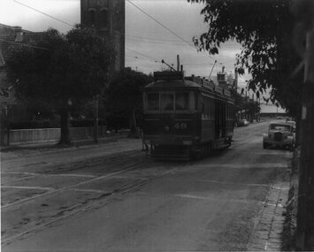 Melbourne Tram Museum
Photograph - VR tram 49 Bay Road Sandringham, 18-9-1956
Photo shows VR tram 49 in Bay Road, shortly after leaving Sandringham Station for Black Rock on 18-9-1956. The tram line closed on 5-11-1956Yields information the Sandringham to Black Rock tramway.Photograph - Black and White, printed on an A4 sheet.At one end of the print " #247 Bay Rd. No. 49 on down Sat. 18-9-1956"trams, tramways, tram 49, bay road, sandringham, black rock, vr trams