Showing 447 items
matching bay view street
-
 Port Melbourne Historical & Preservation Society
Photograph - Excelsior Hall from corner Princes and Bridge Streets, Port Melbourne, David Thompson, Jun 1998
On ending of RSL lease and therefore imminent sale and development of the land - Princes to Station at Bridge - David THOMPSON recorded exterior details of the building.Photo: view from Princes and Bridge Streets. From series of photos of Excelsior Hall ('Diggers' Hall'), RSL Port Melbourne branch headquarters 1948 - 1998. Made June 1998 by David THOMPSON.societies clubs unions and other organisations, excelsior hall, built environment, returned services league, rsl -
Port Melbourne Historical & Preservation Society
Photograph - Excelsior Hall from corner Princes and Bridge Streets, Port Melbourne, David Thompson, Jun 1998
On ending of RSL lease and therefore imminent sale and development of the land - Princes to Station at Bridge - David THOMPSON recorded exterior details of the building.Photo: view from Princes and Bridge Streets, showing Dispensary. From series of photos of Excelsior Hall ('Diggers' Hall'), RSL Port Melbourne branch headquarters 1948 - 1998. Made June 1998 by David THOMPSON.societies clubs unions and other organisations, excelsior hall, built environment, returned services league, rsl -
Port Melbourne Historical & Preservation Society
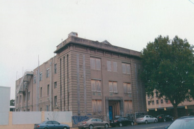
Photograph - View from south, Excelsior Hall, Port Melbourne, David Thompson, Jun 1998
On ending of RSL lease and therefore imminent sale and development of the land - Princes to Station at Bridge - David THOMPSON recorded exterior details of the building.Photo: view from south, showing Station Hotel (redeveloped as residences) and caretaker's cottage at Dispensary (110 Station Street). From series of photos of Excelsior Hall ('Diggers' Hall'), RSL Port Melbourne branch headquarters 1948 - 1998. Made June 1998 by David THOMPSON.societies clubs unions and other organisations, excelsior hall, built environment, returned services league, rsl -
 Port Melbourne Historical & Preservation Society
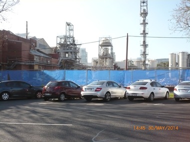
Photograph - Exterior views, J Kitchen & Sons, Port Melbourne, 2011 - 2014
External views of the J Kitchen & Sons site. Some taken October 2011 when manufacturing still occurred on site and some in May 2014 after demoltion work had begun to clear the site for future development; (.01) The Australian Academy of design building at 220 Ingles St (October 2011) (.02) The building which housed the factory outlet shop. Admin building in background. (October 2011) (.03) Part of the Iindustrial complex surrounded by fence in preparation for demolition. (May 2014) (.04) View of the art-deco admin building taken from Ingles St (May 2014) (.05) Corner of the complex already cleared (former shop outlet) (May 2014)built environment - industrial, business and traders - soaps/candles, j kitchen & sons pty ltd, australian academy of design, ingles street -
 Port Melbourne Historical & Preservation Society
Photograph - Demolition, Joshua Bros/UDL distillery buildings, Pickles Street, Port Melbourne, 26 Oct 2002
Digital copies of two colour photographs taken 26.10.2002 showing the demolition of the former Joshua Bros/UDL distillery building on Pickles St. The site was to become the ID apartment complex. .01 - Viewed from Rouse St looking East towards the city with "Portside" apartments at the rear. Retained walls are to the right, on Pickles St, where some of the walls are decoated with paintings of UDL products. .02 - taken from the same spot on Rouse St but looking to the West side of the complex including other apartments on Johnston St and again with "Portside " apartments at the rear.built environment - domestic, built environment - industrial, joshua brothers distillery, udl, sheridan property, id apartments, portside apartments, pickles street -
Port Melbourne Historical & Preservation Society
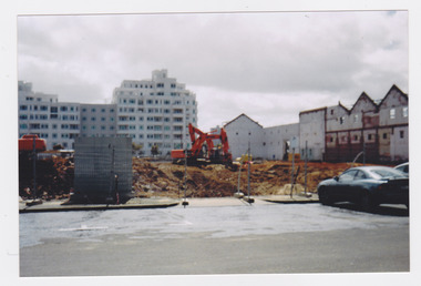
Photograph - Conversion of UDL Distillery to apartments, Pickles Street, Janet Bolitho, 2002 - 2003
Four colour photographs of the conversion of UDL Distillery in Pickles Street to apartments. Taken from Rouse St .01- Wall, Pickles St .02 - Crane and demolition .03 - Blue rear of aprtments under construction .04 - Interior view of construction sitebuilt environment - commercial, joshua brothers distillery, udl, pickles street, id apartments -
Port Melbourne Historical & Preservation Society
Photograph - 160 years of Holy Trinity Anglican Church, Port Melbourne, Ann Gibson, 5 Apr 2014
Shot by Ann Gibson and others on the day of 160 year commemorative "tent service"Photgraphs related to celebrations of 160 years of Holy Trinity, 2014. All photographs taken day of "tent service" April 6, 2014 .01 & .02 - View of "church" and tent .03 - tent and sign as seen from footpath .04 - view of noticeboard .05 - John May and Pat Grainger .06 & .07 Interior of tent .08 - close-up on handwritten tent sign .09 - Rev Noel Whale conducting tent service .10 - congregation at tent servicereligion - anglican (holy trinity), celebrations fetes and exhibitions, rev noel whale, congregation -
Port Melbourne Historical & Preservation Society
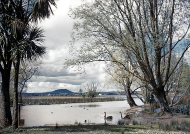
Photograph - Perce White Reserve, Port Melbourne, 1990s
Three photos, origin unknown, of Perce White Reserve. .01 - (landscape) .02 - (portrait) open view into bush .03 - (portrait) dark path into bushNumbers in green on back 22, 23, 20parks and gardens, environment, friends of port melbourne foreshore, perce white reserve, perce mcguire white, perce white -
Port Melbourne Historical & Preservation Society
Photograph - TT Line truck park, Station Pier, Port Melbourne, Lyn Allison, 1993 - 1994
three (3) colour photographs of foreshore Station Pier east side, to create the TTLine truck park. .01 - view West with bulldozer and trucks .02 - "Abel Tasman" with bulldozer in foreground and first row of piles. .03 - view to Port Melbourne across foundations for truck park.piers and wharves - station pier, transport - ferries, abel tasman, harpers starch factory, fox hay timber and hardware pty ltd, london family hotel, band rotunda, tt-line truck park -
 Port Melbourne Historical & Preservation Society
Photograph - Administration Building roof, J Kitchen & Sons, Port Melbourne, Lionel Layfield, 2014 - 2015
Photographs taken by ex-employee of Kitchen's, Lionel Hayfield (refer catalogue numbers 3411 and 3412) just before the building sold to "The Block" - a Channel 9 TV program. See also cat nos 3846, 3847 and 3848The roof series of colour photographs taken inside, and from, the J Kitchen & Sons Administration Building on Ingles St Port Melbourne. Details on the back of photographs. .01-.10 - views on and from the roof, including the water system shed.industry - manufacturing, built environment - industrial, built environment - commercial, demolitions, j kitchen & sons pty ltd -
Port Melbourne Historical & Preservation Society
Photograph - Bass Strait ferry, Oct 1998
Four colour photographs taken from Bass Strait Ferry .01 - outer end of Station Pier with City backdrop .02 - View to beach and London Hotel and east end of Beacon Cove .03 - Station Pier Gatehouse with Beacon Cove and two of the Beacon Cove towers .04 - View to Port Melbourne Beach, London Hotel, Beacon Cove and City skyline viewing platform/folly in foregroundpiers and wharves - station pier, built environment, london family hotel, beacon cove -
 Bendigo Historical Society Inc.
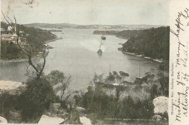
Postcard - GLADYS DEAN COLLECTION: POSTCARD, 1906 - 1908
Coloured photographic postcard. Image has a 1.7cm white border on the right hand side and depicts Mossmans Bay Sydney NSW. The image shows a view of the bay taken from height, several boats can be seen in the bay and houses are on the left hand shore and in the distance. The words Mossmans Bay Sydney Harbour N.S. Wales are printed in white in the lower right hand corner of the image. On the border, the words Mosman's Bay Sydney Harbour are printed in black and the words Wishing you many happy returns of the day are handwritten there also. On reverse it is addressed to Miss Dean McKenzie St Golden Square. A black and white image of palms appear on the left hand side with the words NSW Bangalore Palms in white along the bottom. A one penny stamp is affixed postmarked Bendigo. A symbol of an artists palette with the letters HB is along the top.Symbol - artist palette and letters HBpostcard -
 Bendigo Historical Society Inc.
Photograph - BENDIGO VIEWS COLLECTION: PALL MALL, 1940's
Photograph. Tree lined Pall Mall on the north side, as is the post Office clockand roof of the Law courts. Cars in parking bays on other side. Shamrock Hotel left of photo and a double story building on Williamson Street corner, Myers store next to it. Maples store is in back ground.photograph, streetscape, bendigo's pall mall -
 Victorian Interpretive Projects Inc.
Photograph - colour, Clare Gervasoni, St Peter's Catholic Church, Daylesford, 2015, 14/06/2015
"The fine structure of St. Peter's, with its prettily-decorated interior, which holds crowded congregations at Holy Mass on Sundays, is alone an eloquent testimony of the piety and devotion which permeates the whole parish. Attached to the church is a circulating library, and Catholic papers and other literature are distributed at the church door. Branches of the H.A.C.B. Society and Catholic Federation are doing much good work. (Melbourne Advocate, 17 January 1914) "OPENING AND CONSECRATION OF THE NEW CATHOLIC CHURCH OF ST. PETER’S, DAYLESFORD Cross on St. Peter'sNotwithstanding the inclemency of the weather, the opening of the new Catholic Church of St. Peter’s, yesterday (Sunday), attracted a crowded congregation. Although the rain, which has poured almost incessantly for some days past, had left our roads and streets in the condition for which Daylesford is celebrated in winter weather, and although he storm and rain seemed to increase as the hour announced for the ceremonies approached, the church was filled by a large congregation, comprising all sects and denominations of Christians in and around the district. The beautiful edifice, erected mainly through the zeal, liberality and energy of the respected pastor, presented a most imposing appearance, and reflects infinite credit upon the Rev. Mr. Slattery, and the flock committed to his charge. The church was commenced in November 1863 and has been in the hands of the workmen up to the present time, work being uninterruptedly carried on. On commencing the foundations, it was necessary to excavate until solid clay was reached, which in consequence of the deep rich chocolate soil on the site of the building, had to be carried down to an average depth of 6 feet 6 inches. The foundations were laid with massive stones in courses of 12-inch, and four feet thick, reducing to 3 feet below the floor line. The style of the building is decorated Gothic, and consists of a nave, 80 feet by 30 feet in the clear, and a chancel 18 feet high; from floor line to apex of roof, 47 feet, which is elegantly constructed, consisting of six spans or frames with puncheons resting on carved corbels, low down between the windows. The north side consists of a handsome entrance, near the north-west angle, approached by nine steps of cut stone, and four bays of windows on nave, and a small door on side of chancel, intended as an entry from the sacristy. The south side presents a very handsome view to Victoria street, a beautiful porch entrance giving access to the building on the south-east end of nave; and on the south-west angle a handsome octagonal spire, terminating in an iron cross, with gilt floriations; the height of top of cross, from floor line, is 88 feet. A stone stairs gives access to the organ gallery and the belfry. The whole of the windows are of a handsome geometrical design, and carved in stone, with mullions and tracery, and glazed with amber-tinted glass, the chancel window being 15 feet high, and 8 feet wide. The chancel arch is unusually large, 27 feet St. Peter's interiorhigh and 18 feet wide, and handsomely moulded, and presents a fine appearance from the body of the church. The roof is stained a rich oak, with heavy cornice, and all the walls are smoothly plastered, and colored peach color, giving the amber-tinted glass a beautiful soft cathedral appearance to the interior. The altar is of a very chaste design, the panels being moulded with Gothic heads, and finished in white and gold; the altar rail was not completed, but is intended to be of polished cedar, with carved pillars. The interior fittings will be proceeded with immediately, and to complete the design, an organ gallery, with sittings for about 100 persons besides the choir, will be constructed on the west end. It is intended also to place pillar gaslights on each side of the main entrance, for lighting during vespers in winter. The style of architecture has been strictly carried out, and in the best and most substantial manner. The building has been erected under the superintendence of the architect Mr. John Townsend Brophy, a member of the congregation, and who has discharged his duty with great ability and care. The hour of half-past eleven has scarcely passed when from the sacristy entered His Lordship the Right Rev. Dr. Gould, Bishop of Melbourne, preceded by the Very Rev. Dean Hayes (Sandhurst), the Rev. P. J. Slattery, and a number of boys dressed in white surplices. The Right Reverend Prelate proceeded to the foot of the altar, the Very Rev. the Dean on his right, and the Rev. P. J. Slattery on the left. The prayers usual upon the occasion were read by the Bishop. A procession was then formed, and went around the church in the following order. Several youths bearing wax candles first, next the Very Rev. the Dean, then the Bishop and his train bearers, and following were the Rev. Mr. Slattery and acolytes. Having returned to the altar in the same order, the Deacon (Dean Hayes) and Sub-Deacon (Rev. P. J. Slattery) proceeded to robe his Lordship, who had taken his seat at the epistle side of the altar, for the solemn High Mass, at appropriate times wearing his mitre and bearing his crozier. The mass, which was chanted by the Bishop with touching simplicity and earnestness, was then commenced. The choir, under the direction of Mr. Meunsch, organist, was full and most effective. Mrs. Testar, of Melbourne, having generously offered her valuable services, took the leading soprano solos, and it is scarcely necessary to add, rendered them with exquisite taste and feeling – her beautiful voice being heard with great effect throughout the entire building. The choir consisted of the following ladies and gentlemen who volunteered to aid in the ceremonies upon this most interesting occasion. Ladies: Mrs. Tresar, soprano; Mrs. J.J. McCormick, alto; Miss Julia Conry, soprano; Mrs. Vincent, soprano; Mrs. Aitken, soprano. Gentlemen: H. Guthiel, tenor; Master John Murphy, tenor; James Knox, bass; J. M. Murphy, bass; Mr. Staunton, baritone; Mr. Sourby, alto; Mr. Short, bass. The chant, “Let us adore,” during the procession, was given by Mrs. Vincent with considerable power. The selection of the “Imperial Mass” (Haydn’s No. 3) was felicitous, and the highly artistic and finished manner in which the different parts were sustained, demonstrated that great and persevering care must have been bestowed on the preparation for “the opening day.” The “Kyrie” was given with the full strength and power of the choir. The swelling of the voices in complete harmony, and the pealing of the organ in the midst of incense and prayer, produced a most marked effect upon the congregation. In the “Gloria,” the solos of Mrs. Testar were really beautiful and Mrs. McCormick rendered the alto solos with considerable merit. Mr. Knox sang the part commencing with the words “Qui tolles” with much taste and power. The “Credo” than which we believe there is not a more magnificent piece of sacred music extant, was most successful in its rendering, nor do we ever remember to have heard anything more touching than the manner in which the line “Vetam Venturi in Seculi,” was given by Mrs. Testar. The offertory hymn “Come unto Me all ye that labor,” was given by Mrs. Testar with the most thrilling effect. The “Sanctus” having been sung, in which Mr. Sourby ably rendered an alto solo, the “Agnus Dei” was commenced with a solo by Mrs. McCormick and was given with great taste and feeling, Mrs. Testar, at the conclusion of the “Agnus,” taking up the soprano part. Mass being concluded, the Very Reverend Dean Hayes ascended the altar and proceeded to preach the opening sermon, taking as his text Second Paralipomenon [Chronicles II], 7th chapter and 16th verse – “For I have chosen and have sanctified this place that My hand may be there for ever, and My eyes and My heart may remain there perpetually.” St Peter's manseAt the close of the sermon a collection was made by the very reverend preacher, assisted by John Egan, Esq., Corinella, on behalf of the church, and about fifty pounds were contributed. When it is remembered that 500 tickets had been issues at 10s each, and the inclemency of the weather taken into consideration, the collection may be regarded as a large one. Benediction was sung by the Rev. P. J. Slattery, assisted by Dean Hayes, the choir singing the “O! Salutaris Hostia” and “Laudate.” Handel’s Hallelujah Chorus was sung at the termination of the ceremonies. The vestments issued at Benediction, as well as at the Mass, were of the most gorgeous and beautiful character. When the Benediction was over, the Rev. P. J. Slattery, standing at the front of the altar said– “I wish to say one or two words before the congregation leave. I feel most deeply indebted to all of you who have attended here today for the honor and glory of God, not withstanding the difficulties you had to encounter from this most inclement season. I am truly delighted at such a manifestation of feeling, and will not easily forget it.” The rev. gentleman having disrobed, thanked the members of the choir for their kindness in assisting at the ceremonies, and more especially Mrs. Testar, who had braved all the storm and rain to be present at, and give the advantage of her great musical abilities on, the “opening day.” (Daylesford Mercury, 15 May 1865.)A number of photographs of St Peter's Catholic Church, Daylesford, taken at the 150th anniversary celebration. st peter's catholic church daylesford, decoration, altar decoration, anniversary, daylesford, religion, painting, interior, slattery, gough, d'alton, mcmahon -
 Bendigo Historical Society Inc.
Photograph - JACK EMMETT COLLECTION: PHOTOGRAPH DOWN TO THE BEACH COWES
JACK EMMETT COLLECTION colour photograph 'Down to the beach Cowes 'mounted on cardboard - rear shows rubber stamp -'A.J. Murray commercial photographer -photo shop Cowes .'Won by (Miss ?) Ramage Ladies Table Tennis 'Bay View' Cowes Jan 1933'A.J. Murray commercial photographephotograph, landscape, cowes, 'a.j. murray commercial photographer -
Moorabbin Air Museum
Document (Item) - CAC - F/A 18 Program - A.I.P Technical Training , Oversea Visit By Reg Young 3rd April To 18th April 1982 , Over-View Of Procurement , Control And Shipping Of Materials For F-18/A Engine Bay Doors , Aft Nozzle Fairings And Wing Pylons, CAC - F/A 18 Program - A.I.P Technical Training , Report No.NTF 16-R1
Report No.NTF 16-1 -
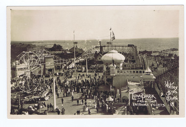 St Kilda Historical Society
Photograph, Whitney Bros Electric Post Card Studio, Luna Park, c. 1900s
Luna Park with crowd milling, aerial view from the entrance towers, St Kilda bay behind.black and white image on front of postcard, unmounted, good conditionFront: Luna Park From The Entrance Towers; Whitney Bros. Photo 18; Back: Whitney Bros, Electric Post Card Studio, Luna Park, St kilda. Melbourne, Australia. -
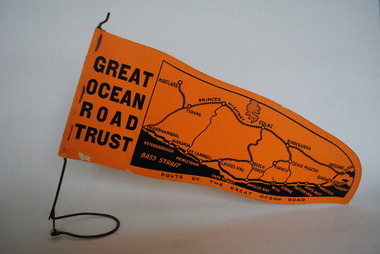 Anglesea and District Historical Society
Pennant, Unknown
Orange pennant flag listing towns on and near the Great Ocean Road. List of town names on pennant - (west to east) Mortlake, Warrnambool, Nirranda, Terang, Port Campbell, Lavers Hill, Colac, Beech Forest, Apollo Bay, Wye, Birregurra, Forrest, Deans Marsh, Peterborough, Princetown, Lorne, Eastern View, Airy's Inlet, Anglesea, Torquay, Geelong, Barwon Heads.GREAT/ OCEAN/ ROAD/ TRUST. Map of Area/ Route of the Great Ocean. (Orange - on wire stand. Printed on both sides.) great ocean road trust -
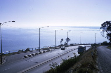 Robin Boyd Foundation
Slide, Robin Boyd, 1967
Colour slide in a mount. View of Port Phillip Bay, Nepean Highway, Olivers Hill, Frankston, VictoriaMade in Australia / 20 / JUN 67M1 / Encircled 44 (Handwritten)slide, robin boyd -
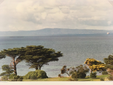 Queenscliffe Historical Museum
Photo of Bay View - Queenscliff, Bay View Queenscliff, 1988
Photographed from tower of Vue Grand Hotel, August 1988.smith, queenscliff -
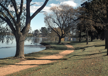 City of Ballarat Libraries
35mm Slide, Lake Wendouree, Ballarat, circa 1950s
Lake Wendouree is often considered the soul of Ballarat according to advertisements from the early 1900's saying "Sydney may have it's Harbour, Melbourne, it's bay but Ballarat has Lake Wendouree." This view shows north shore. Mrs Bon Strange and her husband Bert were well known Ballarat residents. When Mrs Strange died some years ago, her extensive slide collection was sorted through and those relevant to Ballarat were gifted to the Ballarat Library. -
 City of Ballarat Libraries
35mm Slide, Lake Wendouree circa 1950s
A view from the "Fairyland" area of the Wendouree Lake showing Mount Warrenheip in the background. Lake Wendouree is often considered the soul of Ballarat according to advertisements from the early 1900's saying "Sydney may have it's Harbour, Melbourne, it's bay but Ballarat has Lake Wendouree." This may have been Mrs.Strange's favorite spot to photograph the Lake, another image in this series captures the same area in a different mood. Mrs Bon Strange and her husband Bert were well known Ballarat residents. When Mrs Strange died some years ago, her extensive slide collection was sorted through and those relevant to Ballarat were gifted to the Ballarat Library.lake wendouree -
 South Gippsland Shire Council
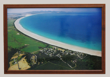
Photograph, Framed, 2003
Framed colour photograph featuring an aerial view of Waratah Bay, the beach and Sandy Point . Wilsons Promontory can be seen in the distance. -
Moorabbin Air Museum
Drawing (Item) - Hudson Ambulance Conversion Luggage Compartments ( Bomb Bay) View From Underneath Nose Looking Aft Drawing No.1
-
 Bayside Gallery - Bayside City Council Art & Heritage Collection
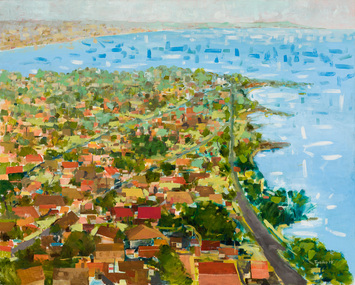
Painting - oil on canvas, John Trebilco, Aerial view of Black Rock, 1978
boats, bay, water, half moon bay, black rock, bayside, john trebilco, aerial, houses, streets, coast, beaumaris, beach road -
 Bendigo Historical Society Inc.
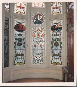
Photograph - FORTUNA COLLECTION - PHOTOGRAPH
Colour photograph of stained windows (interior view) in a bay window setting. Two stained windows to the left and right are the same design, a smaller stained window of a different design is in the centre of them and a small round stained window with a woman (waist view up) above. Partial views of other windows. -
 Bendigo Historical Society Inc.
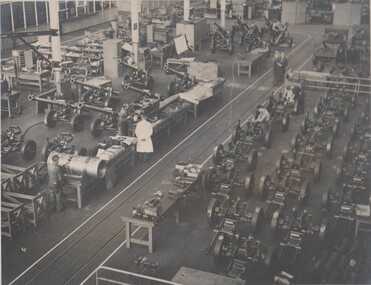
Photograph - BENDIGO ORDINANCE FACTORY COLLECTION: ASSEMBLY BAY OF NO 9 SHOP, 1950s
Overhead view of full construction action of Assembly Bay within No 9 shop at the Bendigo Ordinance factory B&W photo taken in 1950s -
 Kew Historical Society Inc
Photograph, J F C Farquhar, A View in Studley Park Road, 1891
At the beginning of the 1890s, the Kew businessman and Town Councillor, Henry Kellett, commissioned J.F.C. Farquhar to photograph scenes of Kew. These scenes included panoramas as well as pastoral scenes. The resulting set of twelve photographs was assembled in an album, Kew Where We Live, from which customers could select images for purchase.The preamble to the album describes that the photographs used the ‘argentic bromide’ process, now more commonly known as the gelatine silver process. This form of dry plate photography allowed for the negatives to be kept for weeks before processing, hence its value in landscape photography. The resulting images were considered to be finely grained and everlasting. Evidence of the success of Henry Kellett’s venture can be seen today, in that some of the photographs are held in national collections.It is believed that the Kew Historical Society’s copy of the Kellett album is unique and that the photographs in the book were the first copies taken from the original plates. It is the first and most important series of images produced about Kew. The individual images have proved essential in identifying buildings and places of heritage value in the district.This is the earliest known photograph of the exterior of Byram (later Tara Hall). It shows the original red brick fence, its asymmetrical gate and gateposts, with a large terra cotta gargoyle surmounting the higher of the two. The architect, Edward Kilburn designed Byram in the Arts & Crafts style for the industrialist George Ramsden. Construction began in 1888 and was reputed to have lasted three years. The mansion had frontages to Studley Park Road and Stevenson Street, including gardens laid out with great taste, including pleasure grounds, tennis lawn, fruit and flower garden, and paddock. The size of many of the trees in the garden indicate that many survived from the garden of Clifton Villa, the previous single-storeyed house built on the site by the Stevenson brothers. Byram had views to Melbourne and Port Phillip Bay. The house was demolished in 1960, despite opposition from the National Trust (Victoria), and its gardens subdivided into residential allotments.A View in Studley Park Roadkew illustrated, kew where we live, photographic books, henry kellett, byram, tara hall, goathlands -
 Kew Historical Society Inc
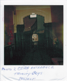
Photograph - 'Otira', 73 Walpole Street, 1978
Sanderson P (1988): '73 Walpole Street (Kew), 'Otira'. Built 1887. Original use - Residence. Architect - Crouch. Henry Berry, a noted philanthropist and salt merchant of Melbourne, was the original owner of this two-storey, boom-period house. Berry occupied the residence until his death in 1923 while in February the following year, the property was auctioned. Subsequently purchased by the Methodist Church for use as a training college for missionaries, a number of additions and alterations were made at that stage including a memorial chapel that was built on the property in 1957.' Otira is now a private residence. Original colour positive photograph (polaroid) of 'Otira', 73 Walpole Street, Kew, taken in 1978 by students in Form 3R at Trinity Grammar School as part of a project. The view in the photograph is of the panelled entrance hall."Photo 2 / Otira entrance / Trinity Bays Project"otira - 73 walpole street, henry berry, historic houses -- kew (vic.), trinity grammar school, melbourne architects -- crouch, interior design -- entrance halls -- 1880s -
 Kew Historical Society Inc
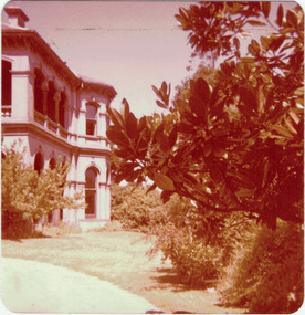
Photograph - 'Mandalay', Molesworth Street (Kew), 1979
Small, square, original colour positive photograph of 'Mandalay', Molesworth Street, Kew, taken in 1979 by Elizabeth Mackie. Side view showing double-storey colonnade faced with cement pilasters on first floor and projecting bay window on both floors.Annotated in ink on reverse: " Mandalay, 3 Molesworth St. / once Morrissey family home / Donated by E Mackie 1979"mandalay, historic houses -- kew (vic.), mansions -- kew (vic.), morrissey family