Showing 28689 items
matching buldah-east-gippsland
-
 Orbost & District Historical Society
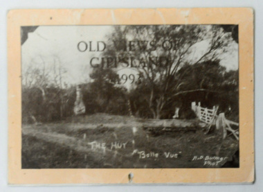
calendar, Old Views of Gippsland 1993, 1992
This item is a useful pictorial reference tool.A 1992 stapled pictorial annual calendar, titled "Old Views of Gippsland".On the front is a black/white photograph of "The Hut Belle Vue" taken by H.D. Bulmer. It contains early photographs of East Gippsland, one for each month. The photographs are sepia. There is a hole for hanging. Some dates have appointments recorded in pen.calendar-old-views-of-gippsland photographs-historic-gippsland -
 Port Fairy Historical Society Museum and Archives
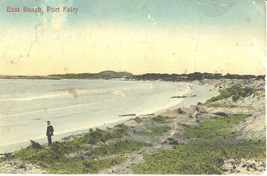
Photograph - Postcard, East Beach Port Fairy
Shows old pier and remnants of wharf railEvidence of former pier and wharf railB&W PhotographEast beach Port Fairybeach, seascape, pier -
 Federation University Historical Collection
Photograph, Gippsland Campus Scholarship & Gippsland Internet Program, c2002
Gippsland Campus Scholarship & Gippsland Internet Program If you can assist with inforrmation on this photograph please use the email link below. gippsland campus collection, gippsland campus scholarship & gippsland internet program, display -
 Lakes Entrance Historical Society
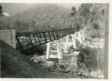
Photograph - Bridges, 1990
Also another photo taken laterColour photograph showing McKillops Bridge across the Snowy River in the High Country near Deddick, East Gippsland near the Victorian / NSW border, south side of bridge, road to Deddick just visible opposite end, taken from west end of bridge. River flowing to right, bridge of timber, steel and concrete, mountains around. East Gippsland Victoriabridges, waterways, topography -
 Orbost & District Historical Society
plan, before 1948
Drainage infrastructure was developed and maintained in this region by the Snowy River Improvement Trust. The Trust was administered by a local committee and its activities funded by a local rate charged on the farmers and land owners in the Trust’s designated district. The level of the rate charged by the Trust was designed to be proportionate to the benefit derived from the works undertaken. Financial assistance was provided by the State Government from time to time for specific projects such as post flood repairs but not for new capital works. The Trust undertook new drainage and river management works including tree planting, rock beach construction and servicing of the drains and flood gates. The Trust also provided a personal flood warning service to the farmers in its district. The Trust ceased to operate in 1997 with the advent of the East Gippsland Catchment Management Authority. The infrastructure developed by the Trust continues to provide a service to the farmers in the region. (ref. 4 East Gippsland CMA Submission to Inquiry into Flood Mitigation Infrastructure in Victoria) This plan is significant as a historical document. The Snowy River Improvement Trust was vital to the Orbost district because of its ability to apply local knowledge and to engage the local farming community.A large plan of divisions of land for the purpose of levying the Snowy River Improvement District - Bete Bolong, Orbost, Waygara, Newmerella and Orbost East. The properties are coloured according to levy amount. The scale is 1" - 20 chains. snowy-river-improvement-trust -
 Lakes Entrance Historical Society
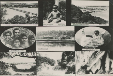
Postcard - Scenes from around Lakes Entrance and Lake Tyers, H D Bulmer, 1930c
Includes Club Hotel, Jemmys Point , Footbridge , Buchan Caves Black and white collage postcard showing views of Lakes Entrance, Buchan and Lake Tyers Station residents to advertise local area East Gippsland Victoriasettlement, buildings, community facilities, aboriginal history -
 Lakes Entrance Historical Society
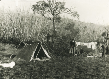
Photograph - Photographers Campsite, 1903 c
Man at fire looks like Nicholas Caire Photographer. Woman Mrs Caire who often travelled with him. Young man possibly H D Bulmer who travelled with Caire and learned photography. Other man helped lug the gearBlack and white photograph showing three men and a woman at a basic campsite of tarpaulin tent washing line and open air cooking in East Gippsland Victoriacamping, photographers -
 Lakes Entrance Historical Society
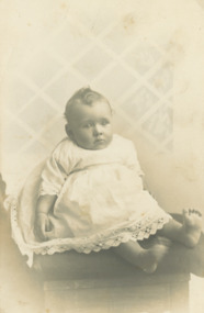
Postcard - Fish Family, Rex Owen Fish, 1/02/2021 12:00:00 AM
First child of John Victor and Myrtle Olive Fish nee GrantSepia toned postcard of Rex Owen Fish aged five months wearing lace trimmed baby frock seated on a chair East Gippsland Victoriagenealogy -
 Lakes Entrance Historical Society
Book, Clements, Eddie and Shepherd, Keith White, Lee, Around the Campfire Ashes. Tales of Old Gippsland, 1986
Stories of people and places of East Gippsland, as recalled by two men who spent schooldays at Bruthen, and many years camping in the bush and enjoying the company of local residents.Ruth Clarktownship -
 Ringwood and District Historical Society
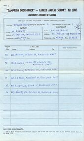
Document, Filled out forms for the "Campaign Door-Knock" Cancer Appeal Sunday 1st June 1958, East Ringwood district
For the district of East Ringwood, Captain S Newley and Lieutenant DE Harrison. Probably arranged through the East Ringwood Progress Association. -
 Whitehorse Historical Society Inc.
Photograph, Basketball Stadium East Burwood
The stadium was opened on the 24th July 1970 by Victorian Premier, Dick Hamer. It was the most famous basketball venue in the 70's & 80's.costing $8mil. The stadium was financed by basketball patrons under the administration of the Nunawading Amateur Basketball Association, a non profit community advancement company.The stadium caters for 7000 players per week (2015).Coloured Photograph of the East Burwood Basketball Stadium, Burwood Hwy, East Burwood. Three people walking away from the complex.basketball stadium - east burwood, sporting venues -
 Orbost & District Historical Society
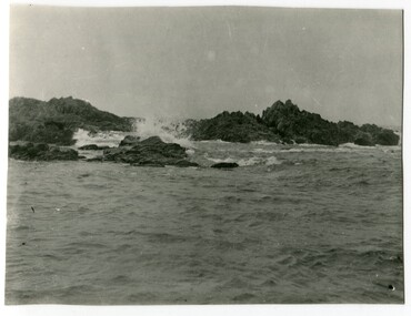
black and white photograph, first half 20th century
This is a scene of Cape Conran, East Gippsland. It appears to be a copy of a postcard which was one of a collection of commercial post cards available to tourists or East Gippsland residents to send to friends or relatives. Cameras in the early 20th century were not a common family possession and a postcard was a common souvenir and way of sending a short message. Postcards are a valuable research tool in the social and environmental history of a community.A black / white photograph of the ocean with rocks in the background. It appears to be a copy of a postcard and has been hand trimmed.cape-conran -
Lakes Entrance Historical Society
Album, LERHS members, LERHS visit to Mallacoota, 2002 c
Small album of photographs taken during LERHS visit to Mallacoota plus those during Mallacoota Historical Society visit to Lakes Entrance Victoria East Gippslandvolunteering, community facilities -
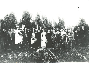 Lakes Entrance Historical Society
Photograph - hop pickers East Gippsland, Victoria, 1910 c
The people in the photograph are dressed up as if a special occasionBlack and white photograph of a group of hop pickers and families, hop poles on ground in front of people, others at back not picked, two bicycles, East Gippsland, Victoriacelebrations, agriculture, farming -
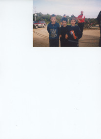 Lakes Entrance Historical Society
Photograph - Deppler/Sotirakis, 2001 c
Jack and James Sotirakis born 13 June 1994, Reece Deppler born 20 February 1993Colour photograph of three young boys Reece Deppler with Jack and James Sotirakis taken at a local celebration, shrubs in background decorated with streamers East Gippsland Victoriagenealogy, celebration -
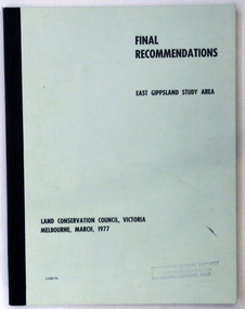 Orbost & District Historical Society
document, FINAL RECOMMENDATIONS E. GIPPSLAND STUDY AREA - LAND CONSERVATION COUNCIL, VICTORIA March 1977, March 1977
Established in 1971, the Land Conservation Council operated under the Land Conservation Council Act 1970. In July 1997, the Environment Conservation Council Act 1997 came into operation. This Act revoked the Land Conservation Council Act 1970 and abolished the Land Conservation Council. An Environment Conservation Council was established in its place. (ref. TROVE) This document is a useful reference tool.A document of 75 pp with a pale green cover and black print, titled Final Recommendations East Gippsland Study area. Land Conservation Council, Melbourne, March, 1977.land-conservation-east-gippsland -
Lakes Entrance Historical Society
Book, Cox, Rev. George, Notes on Gippsland History Vol. 2. The Beginnings of Gippsland, 1990
An edited version of Rev. George Coxs Notes on Gippsland History which appeared in Gippsland Standard from 1911 to 1930, this volume dealing with the years 1840 to 1841periodicals -
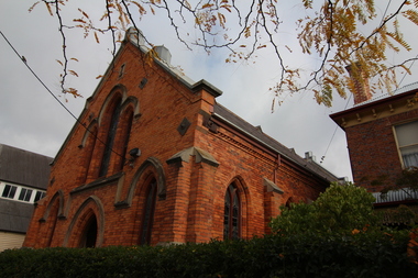 Victorian Interpretive Projects Inc.
Photograph - digital, Clare Kathleen Gervasoni, Barkly Street Uniting Church, Ballarat East, 2015, 2015
Started as a Wesleyan Church. Up for Auction in April 2015.Brick Church in Barky Street, Ballarat East.barkly street uniting church, barkly street wesleyan church, churches -
 Whitehorse Historical Society Inc.
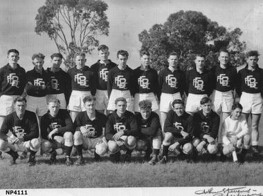
Photograph - Black and white photo, East Burwood Football Club, C 1948/49
Names of players on card in with photograph East Burwood Football ClubTaken on the football ground.east burwood football club c1948/49, sporting clubs, football clubs -
Lakes Entrance Historical Society
Financial record - Ledger, Country Roads Board Wages Ledger, 1953
A Ledger of Wages paid to Country Roads Board employees of East Gippsland VictoriaA Ledger of Wages paid to Country Roads Board employees of East Gippsland Victoriaaccounts book -
 Orbost & District Historical Society
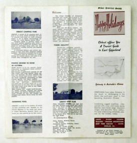
pamphlet, Snowy River Mail, Happy Holidays
This pamphlet was probably produced for use in the Slab Hut (Orbost Visitor Information Centre)These pamphlets are useful reference tools and reflect the tourism history of the local area.Two single page tourist brochures, printed on both sides and folded in the middle. They are white with pink and blue print. and have a map of East Gippsland and descriptions of places to visit.tourism-orbost -
 Lakes Entrance Historical Society
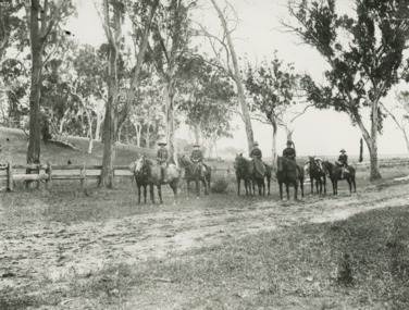
Photograph - Howitt family/Tarli Karng Expedition
Black and white photograph of five people on horseback with three pack horses identified as Howitt family A W Howitt, Annie Howitt, Mary Howitt East Gippsland VictoriaExpedition to Tarli Karng 'Setting Out'people, genealogy, local history, expedition -
 Lakes Entrance Historical Society
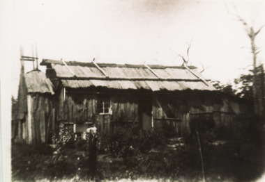
Photograph - Settlers' Dwelling, 1880 - 1890 c
Black and white photograph of pioneer iron bark slab hut typical of early settlers dwellings with chimney and skillion at end with early garden shown East Gippsland Victoriasettlement, housing -
Phillip Island and District Historical Society Inc.
Book, Broadbent's Official Road Guides Company, Broadbent's official guide : Gippsland and south-east corner of N.S.W. incorporating large scale maps, 1950
J.P. Anderson, 97 Salmon St., Hastings'victoria, guidebooks -
 Victorian Aboriginal Corporation for Languages
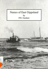
Book, P D Gardner, Names of East Gippsland : their origins, meanings and history, 1992
Detailed examination of the origins of local names from Mallacoota to Marlo and from Wingan Inlet to Willis. Includes explanations of the origins of major towns and their features.Maps, b&w illustrations, b&w photographskrauatungalung, gunnai, kurnai, bidawal, east gippsland, lake tyers, point hicks, -
Lakes Entrance Historical Society
Memorabilia, Early Farming Scenes of East Gippsland, 1985
Calendar issued as part of Victorian 150th Anniversary celebrations1986 Calendar, beige coloured plastic cover with white spiral bound plastic spine, photo on front cover is of Bullock Team carting a wagon with wool balesdocuments, calendars -
Lakes Entrance Historical Society
Book, East Gippsland National Estate Report, 1996
109 printed pages, plastic envelope containing maps inside rear cover, spiral wire boundBuff coloured cover with leaf pattern, left side of cover is brown, rear cover is monotone buff.documents, reports -
Lakes Entrance Historical Society
Book, Vantree Pty Ltd Shearwater Environmetal Management, East Gippsland - Creating a Community Heritage Plan, 2002
This plan provides for the long-term Coastal Action Planwaterways, environment, tourism, boats and boating -
Lakes Entrance Historical Society
Book, Rule, Hilda, East Gippsland Past and Present, 1980
History of Nowa Now for the 'Back to Nowa Nowa' in September 1980. Includes photographs.township, timber industry, settlement -
Koorie Heritage Trust
Book, O'Bryan, Denis, Pioneering East Gippsland, 1983
East Gippsland61 p.; maps; ill.; 20 cm.East Gippslandvictoria. east gippsland region, to date. | gippsland (vic.) -- history.