Showing 403 items matching "dairy farms"
-
 Melbourne Royal
Photograph, Double Take
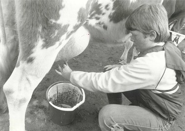
... farm experiences cow dairy cow milking Animal Nursery ...This photograph shows a young boy hand-milking a cow in the Animal Nursery at the Royal Melbourne Show, unknown year. From the early 1990s, the Animal Nursery introduced programs where visitors could see more farm experiences, such as milking cows, sheering sheep, and an ewe birthing centre.Black and white photograph, landscape, printed on glossy paper.[annotations on reverse] Pg 27 67% / W.F.08 1.55 / 3 / DOUBLE TAKE / 18 CARLYLE ST. ASHWOOD / VICTORIA, 3147. 25 7635 / 0 1192-C29 / P. 11/ 33% /children, kids at show, farm experiences, cow, dairy cow, milking, animal nursery -
 Eltham District Historical Society Inc
Photograph - Digital Photograph, Alan King, Blue Lake, Plenty Gorge Park, 2008
A quarry was transformed into the Blue Lake. Published: Nillumbik Now and Then / Marguerite Marshall 2008; photographs Alan King with Marguerite Marshall.; p179 The dramatic steep-sided Plenty Gorge lies along the divide of two geological areas, and separates the Nillumbik Shire and the City of Whittlesea. On the Nillumbik side are undulating hills and sedimentary rock, and in Whittlesea, lies a basalt plain formed by volcanic action up to two million years ago. This provides the Plenty Gorge Park with diverse vegetation and habitats, making it one of Greater Melbourne’s most important refuges for threatened and significant species. The park, established in 1986, consists of around 1350 hectares, and extends 11 kilometres along the Plenty River, from Greensborough to Mernda. It provides a wildlife corridor for around 500 native plant and 280 animal species. The area’s plentiful food and water attracted the Wurundjeri Aboriginal people and then European settlers. By 1837 squatters had claimed large runs of land for their sheep and cattle. The Plenty Valley was among the first in the Port Phillip District to be settled - mainly in the less heavily timbered west - and was proclaimed a settled district in 1841.But by the late 1880s, the settlers’ extensive land clearing for animal grazing, then agriculture, depleted the Wurundjeri’s traditional food sources, which helped to drive them away. Many Wurundjeri artefacts remain (now government protected), and so far 57 sites have been identified in the park, including scarred trees, burial areas and stone artefacts. Pioneer life could be very hard because of isolation, flooding, bushfires and bushrangers. Following the Black Thursday bushfires of 1851, basalt was quarried to build more fire-resistant homes. Gold discoveries in the early 1850s swelled the population, particularly around Smugglers Gully; but food production made more of an impact. In the late 1850s wheat production supplanted grazing. In the 1860s the government made small holdings available to poorer settlers. These had the greatest effect on the district, particularly in Doreen and Yarrambat, where orchards were established from the 1880s to 1914. Links with a prominent early family are the remains of Stuchbery Farm, by the river’s edge bounded by Smugglers Gully to the north and La Trobe Road, Yarrambat, to the east. The Stuchberys moved to the valley in 1890, and the family still lives in the area. In 1890, Alfred and Ada first lived in a tent where four children were born, then Alfred built the house and outbuildings around 1896. They planted an orchard, then a market garden, and developed a dairy. The family belonged to the local Methodist and tennis communities. Their grandson Walter, opened the Flying Scotsman Model Railway Museum in Yarrambat, which his widow, Vi, continues to run. Wal was also the Yarrambat CFA Captain for 22 years until 1987. Walter sold 24 hectares in 1976 for development - now Vista Court - and in 1990, the remaining 22.6 hectares for the park. Remaining are an early stone dairy and remnants of a stone barn, a pig sty and a well. Until it was destroyed by fire in 2003, a slab hut stood on the Happy Hollow Farm site, at the southern end of the park. The hut is thought to have been built in the Depression around 1893. This was a rare and late example of a slab hut with a domestic orchard close to Melbourne. Emmet Watmough and his family first occupied the hut, followed by a succession of families, until the Bell family bought it around 1948. There they led a subsistence lifestyle for 50 years, despite encroaching Melbourne suburbia. The Yellow Gum Recreation Area includes the Blue Lake, coloured turquoise at certain times of the year. Following the 1957 bushfires, this area was quarried by Reid Quarries Pty Ltd for Melbourne’s first skyscrapers, then by Boral Australia. However in the early 1970s water began seeping into the quarry forming the Blue Lake and the quarry was closed. The State Government bought the site in 1997 and opened it as a park in 1999.This collection of almost 130 photos about places and people within the Shire of Nillumbik, an urban and rural municipality in Melbourne's north, contributes to an understanding of the history of the Shire. Published in 2008 immediately prior to the Black Saturday bushfires of February 7, 2009, it documents sites that were impacted, and in some cases destroyed by the fires. It includes photographs taken especially for the publication, creating a unique time capsule representing the Shire in the early 21st century. It remains the most recent comprehenesive publication devoted to the Shire's history connecting local residents to the past. nillumbik now and then (marshall-king) collection, blue lake, plenty gorge park -
 Eltham District Historical Society Inc
Photograph - Digital Photograph, Marguerite Marshall, Stuchbery Farm dairy, 14 March 2008
... Stuchbery Farm dairy... Stuchbery dairy Stuchbery Farm farm buildings Yarrambat Plenty Gorge ...Stuchbery Farm was situated on the Plenty River bounded by Smugglers Gully to the north and La trobe Road, Yarrambat, to the east. Alan and Ada Stutchbery moved to the valley in 1890, first living in a tent where four children were born. Alfred built a home and outbuildings around 1896. They planted an orchard, then a market garden and developed a dairy. Published: Nillumbik Now and Then / Marguerite Marshall 2008; photographs Alan King with Marguerite Marshall.; p179 The dramatic steep-sided Plenty Gorge lies along the divide of two geological areas, and separates the Nillumbik Shire and the City of Whittlesea. On the Nillumbik side are undulating hills and sedimentary rock, and in Whittlesea, lies a basalt plain formed by volcanic action up to two million years ago. This provides the Plenty Gorge Park with diverse vegetation and habitats, making it one of Greater Melbourne’s most important refuges for threatened and significant species. The park, established in 1986, consists of around 1350 hectares, and extends 11 kilometres along the Plenty River, from Greensborough to Mernda. It provides a wildlife corridor for around 500 native plant and 280 animal species. The area’s plentiful food and water attracted the Wurundjeri Aboriginal people and then European settlers. By 1837 squatters had claimed large runs of land for their sheep and cattle. The Plenty Valley was among the first in the Port Phillip District to be settled - mainly in the less heavily timbered west - and was proclaimed a settled district in 1841. But by the late 1880s, the settlers’ extensive land clearing for animal grazing, then agriculture, depleted the Wurundjeri’s traditional food sources, which helped to drive them away. Many Wurundjeri artefacts remain (now government protected), and so far 57 sites have been identified in the park, including scarred trees, burial areas and stone artefacts. Pioneer life could be very hard because of isolation, flooding, bushfires and bushrangers. Following the Black Thursday bushfires of 1851, basalt was quarried to build more fire-resistant homes. Gold discoveries in the early 1850s swelled the population, particularly around Smugglers Gully; but food production made more of an impact. In the late 1850s wheat production supplanted grazing. In the 1860s the government made small holdings available to poorer settlers. These had the greatest effect on the district, particularly in Doreen and Yarrambat, where orchards were established from the 1880s to 1914. Links with a prominent early family are the remains of Stuchbery Farm, by the river’s edge bounded by Smugglers Gully to the north and La Trobe Road, Yarrambat, to the east. The Stuchberys moved to the valley in 1890, and the family still lives in the area. In 1890, Alfred and Ada first lived in a tent where four children were born, then Alfred built the house and outbuildings around 1896. They planted an orchard, then a market garden, and developed a dairy. The family belonged to the local Methodist and tennis communities. Their grandson Walter, opened the Flying Scotsman Model Railway Museum in Yarrambat, which his widow, Vi, continues to run. Wal was also the Yarrambat CFA Captain for 22 years until 1987. Walter sold 24 hectares in 1976 for development - now Vista Court - and in 1990, the remaining 22.6 hectares for the park. Remaining are an early stone dairy and remnants of a stone barn, a pig sty and a well. Until it was destroyed by fire in 2003, a slab hut stood on the Happy Hollow Farm site, at the southern end of the park. The hut is thought to have been built in the Depression around 1893. This was a rare and late example of a slab hut with a domestic orchard close to Melbourne. Emmet Watmough and his family first occupied the hut, followed by a succession of families, until the Bell family bought it around 1948. There they led a subsistence lifestyle for 50 years, despite encroaching Melbourne suburbia. The Yellow Gum Recreation Area includes the Blue Lake, coloured turquoise at certain times of the year. Following the 1957 bushfires, this area was quarried by Reid Quarries Pty Ltd for Melbourne’s first skyscrapers, then by Boral Australia. However in the early 1970s water began seeping into the quarry forming the Blue Lake and the quarry was closed. The State Government bought the site in 1997 and opened it as a park in 1999.This collection of almost 130 photos about places and people within the Shire of Nillumbik, an urban and rural municipality in Melbourne's north, contributes to an understanding of the history of the Shire. Published in 2008 immediately prior to the Black Saturday bushfires of February 7, 2009, it documents sites that were impacted, and in some cases destroyed by the fires. It includes photographs taken especially for the publication, creating a unique time capsule representing the Shire in the early 21st century. It remains the most recent comprehenesive publication devoted to the Shire's history connecting local residents to the past. nillumbik now and then (marshall-king) collection, ada stuchbery, alan stuchbery, dairy, stuchbery farm, farm buildings, yarrambat, plenty gorge park -
 Wodonga & District Historical Society Inc
Domestic object - Small Butter Churn, E. Cherry & Sons, c1880 - 1920
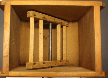
North east Victoria was a major dairy producing region in the late nineteenth century. The Wodonga Butter Factory Ltd was established in 1892. Many families living in the town or on farms also owned their own cow for family needs and produced their milk and butter. This churn is representative of the equipment they used to process their own dairy products at home. This churn was made by E. Cherry & Sons which was established in Gisborne, Victoria in 1858. Edward Cherry (1830-1910) arrived in Australia from Hertfordshire, England, in 1855. The business manufactured churns and in 1875 opened a larger factory. On his death, the business was taken over by his son and continued to operate until the 1970s.This item has strong links to the history of Wodonga and north east Victoria. It has interpretative potential in the areas of local agricultural history, and the social history of food and farming.A wooden butter churn with metal turning handle and removable lid. The wooden paddle inside is attached to the turning handle which rotates to churn the butter. The model number is T1. It was probably made by E Cherry & Sons of Gisborne although the brand is blurred.On one side in black: "T 1"butter churns, dairying industry, domestic appliances, e. cherry churns -
 City of Kingston
Photograph - Colour, Circa 1993
Edithvale is a suburb in the City of Kingston. It is located between Aspendale and Chelsea on the Port Phillip Bay and built within remnant areas of the Carrum Carrum swamp. The foreshore precinct comprises a wide sandy beach, with low sand dunes and numerous historic boat sheds. The suburb consists of older style dwellings and former holiday houses, combined with mid-century housing and newer homes. The large blocks are increasingly subdivided and the existing dwellings demolished to accommodate units and townhouses, thus changing the landscape of the area and reducing the tree canopy.The beachside suburb of Edithvale was previously part of the extensive Carrum Carrum Swamp. The area was once a source of fish and eels for the Mayone-Bulluk clan of the Bunurong people. Over time the area was drained and predominantly devoted to dairy farming and holiday houses. The farms were gradually sold and subdivided with a large number of homes built after World War II and in the 1960s. Edithvale is mainly residential with a shopping strip along Nepean Highway but little significant industry was ever established in the area apart from a plaster works and confectionary factory, both now closed.Aerial colour photograph of Edithvale as viewed from Alexandra Avenue in the north to Ella Grove Chelsea/Edithvale in the south. The area is built-up with residential housing and facilities including Edithvale Primary School, numerous churches and the Edithvale Railway station. Large sections depict the remnant Carrum Carrum swamp. Edithvale Common and the former "Duck Inn" (Melbourne Water/Friends of Edithvale Seaford Wetlands) can be seen. Edithvale Recreational reserve, the velodrome and Edithvale Public Golf Course are prominent. The image shows vacant land in the area now known as Aspendale Gardens and the newer residential section of Chelsea Heights is not developed. A bike path has been established to cover the secondary drain. The Golf Links Court residential development located off Hughes Avenue is a large vacant block.Yellow circular adhesive sticker on plastic Black ink (marker): * (asterisk) Black type on white adhesive sticker: P000108edithvale, aspendale, chelsea, carrum carrum swamp -
 Flagstaff Hill Maritime Museum and Village
Domestic object - Butter Pats
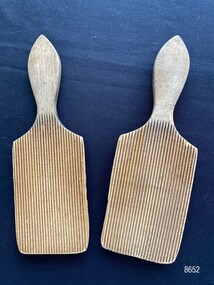
... the dairy farms of South-West Victoria. Flagstaff Hill Maritime ...Butter pats (also known as butter paddles, butter hands and butter workers) were widely used until the mid 20th century to form and shape butter that came out of butter churns.The butter pats are an example of an everyday domestic object that would have been an item in most farm households particularly the dairy farms of South-West Victoria.A pair of wooden butter pats with shaped handles. One side of the pat is covered with fine grooves the other side is flat.flagstaff hill maritime museum and village, great ocean road, shipwreck coast, warrnambool, domestic object, butter pats, butter making, butter paddles -
University of Melbourne, Burnley Campus Archives
Album - Black and white and colour slides, Teaching Horticulture, 1952-1969
Large collection of slides used for teaching Horticulture. Difficult to identify whether they were taken at Burnley. Labelled and numbered 1-2501. Some dated but spread over 1950's to 1960's. Also 57 slides similar to 1-50 labelled but not numbered. Some photographs have been catalogued elsewhere. Missing numbers have been mixed up with other photographs. 1-50 Mostly fungal diseases. 57 slides not numbered - fungal diseases. 1-29 Mostly mosses. 31-41 Mostly liverworts and hornworts. 43-60 Ferns. 61-73 selaginella. 75-84 Ferns 85-114 Gymnosperms 115-1236 Miscellaneous 117-141 Angiosperms 142-294 Biology 296-307 Orchidaceae 311-316 Acacias 796-841 Trees 866-889 Roses 955-984 Eucalyptus 1009-1046 Greenhouse. 1052-1086, 1097-1152 Propagating fruit trees. 1087-1090 Cacti. 1151-1187 Planting and pruning principles. 1196-1218 Orchard, Nursery. 1211 June 1956. 1215 8/3/57. 1228-1258 Orchard Management. 1263-1345 Crafting and reworking. 1346-1373 Bulk handling. 1390-1400 Leaf scorch. 1424-1472 Vegetables.1473-1512 Potatoes, Research farm Toolangi 2/54. 1514-1686 Garden Design. 1688-1695 Cow Paddock, and in flood. 1958, Students. 1795-1798 P.R.I. 1823 Rolling the Surface (New Admin Building)1828-32.1831-1838 Beaumaris Feb 1958.1840-1846 P. Vejjajiva's Farewell 23.2.1958. Pruning Day 2/7/60. 1977-1990 Genetics. 1991-2018 Weeds. 2020-2-50 Erosion. 2023 10/65 and soil conservation. 2072-2136 Fertilizers. 2144-2149 Rhizobia 1950's. 2155-2157 Lime. 2160-2228 Plough, Cultivators, etc. 2246-2296 Tatura 12/59. 2301-2237 Beef and Dairy Cattle. 2338-2354 Sheep. 2355-2372 Crops. 2357-2363 1952. 2364 1958. 2373-2397 Fodder conservation 1952-1956. 2398-2411 Fences. 2398-2406 11/52. 2418-2248 Longerenong Field day 1964. 2451-2455 Boom Sprayer 1960. Glasshouse Wagga Agric College Oct 69. Apr 84 M3 16-18 Cultivator? 2458-2483 Hydraulics,Power Farming Dec 1966-Mar 1967. 2487-2488 Hydraulics Vane Pump Construction. 2491-2500 Mechanics. 2501 Rack Shaker. Extra 13 Pond life. Some slides see B18.0001: 1676, 1684, some between 1711-1792, 1881, some between 1911-1953.Not scanned yet.teaching, horticulture, greenhouse, propagation, pruning, cacti, planting, orchard nursery, orchard management, grafting and reworking, potatoes, toolangi, garden design, lagoon paddock, beaumaris excursion, p.vejjajiva, lagoon paddock in flood, fungal diseases, genetics, weeds, erosion, fertilizers, rhyzobia, lime, cultivation, tatura, cattle, sheep, crops, fodder, fences, hydraulics, mechanics, longerenong, cow paddock, plough, cultivator, boom sprayer, wagga agricultural college, vane pump -
 National Wool Museum
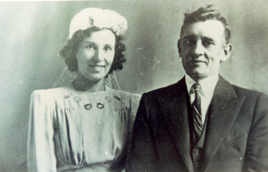
Photograph - Wedding Photo of Gladys Harris and Charles Allen, 1937
This photograph shows Charles Winnet Daniel Allen and Gladys Eileen Harris on their wedding day, 18th December 1937. This photographs relates to the fox fur coat which is now part of the National Wool Museum Collection, NWM-9090. "The foxes were shot in the 1950's by my Father, Charles Winnet Daniel Allen at two properties around Bacchus Marsh. One was Greystones at Glenmore, owned by the O'Keith family and the other was at Parwan, owned by the Miles Family. In the late 1940's and early 1950's, the Government put a bounty on the fox head. A pair of ears were sent to the Council and you were paid 2 pennies and the skins were sold to a skin buyer. My Father would go out on moon lit nights and shoot the foxes then skin them, which he would peg on a board to dry. He took 21 fox skins to Nettlebergs Pty. Ltd., Furriers at 173 Elizabeth Street Melbourne, Victoria, to have this coat made for my Mother, Gladys Eileen Allen. It cost Twenty Pound and Nine Shillings to have the skins made into this coat. My Father died on the 1st July 1982 and my Mother on the 15th October 1993, aged 76. This coat was inherited by me Theresa Joy Hodge (nee Allen) on the passing of my Mother. I have worn it on cold days, but seeing that I am 84 and the coat is 74 years old, I would like to donate it to you, as I have no-one to leave it to and hope that you and the visitors to your Museum will enjoy looking at it." Theresa Hodge, 2025 Theresa was a dairy farmer, who grew up in Bacchus Marsh with her parents, before moving to South Australia in 1980 to a 167 acre farm in Burrungale.Black and white photograph a man and a woman standing together. The woman is wearing a wedding gown and headpiece, and the man is wearing a suit.back: [handwritten] Wedding Photo of Gladys Harris / and Charles Allen 1937 / 17-3-1994 / 18-12-37 / Church of England / 18-12-1937 / ORIGINAL: / a. Surmon back: [printed] ALLEYNE HOCKLEY / 12 WILKIE STREET / CASTLEMAINE 3450 / Phone 721425 back: [printed] Kodak / PAPERfox fur coat, fashion, hunting, pest eradication, farming, rural life, bacchus marsh, greystones, glenmore, parwan, fox, nettlebergs pty ltd, furriers, clothing, theresa hodge, charles allen, gladys allen, wedding -
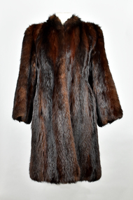 National Wool Museum
Textile - Fox Fur Coat, Nettlebergs Pty. Ltd, 1950
"The foxes were shot in the 1950's by my Father, Charles Winnet Daniel Allen at two properties around Bacchus Marsh. One was Greystones at Glenmore, owned by the O'Keith family and the other was at Parwan, owned by the Miles Family. In the late 1940's and early 1950's, the Government put a bounty on the fox head. A pair of ears were sent to the Council and you were paid 2 pennies and the skins were sold to a skin buyer. My Father would go out on moon lit nights and shoot the foxes then skin them, which he would peg on a board to dry. He took 21 fox skins to Nettlebergs Pty. Ltd., Furriers at 173 Elizabeth Street Melbourne, Victoria, to have this coat made for my Mother, Gladys Eileen Allen. It cost Twenty Pound and Nine Shillings to have the skins made into this coat. My Father died on the 1st July 1982 and my Mother on the 15th October 1993, aged 76. This coat was inherited by me Theresa Joy Hodge (nee Allen) on the passing of my Mother. I have worn it on cold days, but seeing that I am 84 and the coat is 74 years old, I would like to donate it to you, as I have no-one to leave it to and hope that you and the visitors to your Museum will enjoy looking at it." Theresa Hodge, 2025 Theresa was a dairy farmer, who grew up in Bacchus Marsh with her parents, before moving to South Australia in 1980 to a 167 acre farm in Burrungale.Dark brown fox fur coat with silk lining. Three eye and hook clasps at front edges of coat.fox fur coat, fashion, hunting, pest eradication, farming, rural life, bacchus marsh, greystones, glenmore, parwan, fox, nettlebergs pty ltd, furriers, clothing, theresa hodge, charles allen, gladys allen -
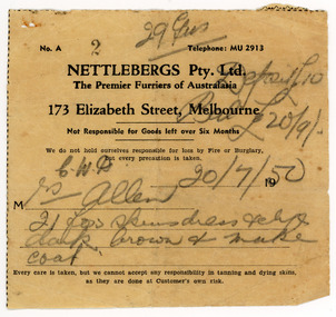 National Wool Museum
Document - Receipt, Fox Fur Coat, Nettlebergs Pty Ltd, Nettlebergs Pty. Ltd, 20/7/1950
This receipt is for a fox fur coat made in Melbourne in 1950 by Nettlebergs. It is associated with the fox fur coat in the National Wool Museum Collection, NWM-9090. "The foxes were shot in the 1950's by my Father, Charles Winnet Daniel Allen at two properties around Bacchus Marsh. One was Greystones at Glenmore, owned by the O'Keith family and the other was at Parwan, owned by the Miles Family. In the late 1940's and early 1950's, the Government put a bounty on the fox head. A pair of ears were sent to the Council and you were paid 2 pennies and the skins were sold to a skin buyer. My Father would go out on moon lit nights and shoot the foxes then skin them, which he would peg on a board to dry. He took 21 fox skins to Nettlebergs Pty. Ltd., Furriers at 173 Elizabeth Street Melbourne, Victoria, to have this coat made for my Mother, Gladys Eileen Allen. It cost Twenty Pound and Nine Shillings to have the skins made into this coat. My Father died on the 1st July 1982 and my Mother on the 15th October 1993, aged 76. This coat was inherited by me Theresa Joy Hodge (nee Allen) on the passing of my Mother. I have worn it on cold days, but seeing that I am 84 and the coat is 74 years old, I would like to donate it to you, as I have no-one to leave it to and hope that you and the visitors to your Museum will enjoy looking at it." Theresa Hodge, 2025 Theresa was a dairy farmer, who grew up in Bacchus Marsh with her parents, before moving to South Australia in 1980 to a 167 acre farm in Burrungale.Single sided paper receipt with black printed text and handwritten text in pencil.front: [printed] No. A / 2 / Telephone: MU 2913 / NETTLEBERGS Pty. Ltd. / The Premier Furriers of Australasia / 173 Elizabeth Street, Melbourne / Not Responsible for Goods left over Six Months / We do not hold ourselves responsible for loss by Fire or Burglary, / but every precaution is taken. / 19 / M / Every care is taken, but we cannot accept any responsibility in tanning and dying skins, / as they are done at Customer's own risk. front: [handwritten] 29 ? / Deposit £10 / Bal £20/9 / C. W. A. 20/7/50 / Mrs Allen / 21 fox skins dress pelts / dark brown + make / coatfox fur coat, fashion, hunting, pest eradication, farming, rural life, bacchus marsh, greystones, glenmore, parwan, fox, nettlebergs pty ltd, furriers, clothing, theresa hodge, charles allen, gladys allen -
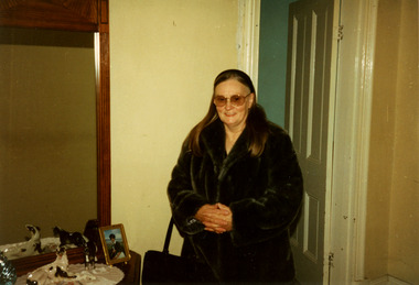 National Wool Museum
Photograph - Theresa Joy Hodge Wearing Fox Fur Coat, 1995
This photograph shows Theresa Joy Hodge wearing the fox fur coat her father made, which is now part of the National Wool Museum Collection, NWM-9090. "The foxes were shot in the 1950's by my Father, Charles Winnet Daniel Allen at two properties around Bacchus Marsh. One was Greystones at Glenmore, owned by the O'Keith family and the other was at Parwan, owned by the Miles Family. In the late 1940's and early 1950's, the Government put a bounty on the fox head. A pair of ears were sent to the Council and you were paid 2 pennies and the skins were sold to a skin buyer. My Father would go out on moon lit nights and shoot the foxes then skin them, which he would peg on a board to dry. He took 21 fox skins to Nettlebergs Pty. Ltd., Furriers at 173 Elizabeth Street Melbourne, Victoria, to have this coat made for my Mother, Gladys Eileen Allen. It cost Twenty Pound and Nine Shillings to have the skins made into this coat. My Father died on the 1st July 1982 and my Mother on the 15th October 1993, aged 76. This coat was inherited by me Theresa Joy Hodge (nee Allen) on the passing of my Mother. I have worn it on cold days, but seeing that I am 84 and the coat is 74 years old, I would like to donate it to you, as I have no-one to leave it to and hope that you and the visitors to your Museum will enjoy looking at it." Theresa Hodge, 2025 Theresa was a dairy farmer, who grew up in Bacchus Marsh with her parents, before moving to South Australia in 1980 to a 167 acre farm in Burrungale.Colour photograph showing an interior view of a woman wearing sunglasses and a fox fur coat. She is standing in front of a doorway, and beside a dresser which has a mirror, ornaments and a photograph.back: [handwritten] 1995 Winter / Theresa Allen back: [printed] Kodak / Official Sponsor / of the / Olympic Gamesfox fur coat, fashion, hunting, pest eradication, farming, rural life, bacchus marsh, greystones, glenmore, parwan, fox, nettlebergs pty ltd, furriers, clothing, theresa hodge, charles allen, gladys allen -
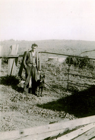 National Wool Museum
Photograph - Charles Winnet Daniel Allen, Bacchus Marsh, 1939
This photograph shows Theresa Joy Hodge's father Charles Winnet Daniel Allen on property in the Bacchus Marsh area, where he shot foxes which which were turned into a fox fur coat, which is now part of the National Wool Museum Collection, NWM-9090. "The foxes were shot in the 1950's by my Father, Charles Winnet Daniel Allen at two properties around Bacchus Marsh. One was Greystones at Glenmore, owned by the O'Keith family and the other was at Parwan, owned by the Miles Family. In the late 1940's and early 1950's, the Government put a bounty on the fox head. A pair of ears were sent to the Council and you were paid 2 pennies and the skins were sold to a skin buyer. My Father would go out on moon lit nights and shoot the foxes then skin them, which he would peg on a board to dry. He took 21 fox skins to Nettlebergs Pty. Ltd., Furriers at 173 Elizabeth Street Melbourne, Victoria, to have this coat made for my Mother, Gladys Eileen Allen. It cost Twenty Pound and Nine Shillings to have the skins made into this coat. My Father died on the 1st July 1982 and my Mother on the 15th October 1993, aged 76. This coat was inherited by me Theresa Joy Hodge (nee Allen) on the passing of my Mother. I have worn it on cold days, but seeing that I am 84 and the coat is 74 years old, I would like to donate it to you, as I have no-one to leave it to and hope that you and the visitors to your Museum will enjoy looking at it." Theresa Hodge, 2025 Theresa was a dairy farmer, who grew up in Bacchus Marsh with her parents, before moving to South Australia in 1980 to a 167 acre farm in Burrungale.Black and white photograph featuring a man standing on a rural property with a dog beside him. A gate, fencing and water tank are shown in the background.back: [handwritten] 1939 / Charles Winnet Daniel / Allen back: [printed] FUJIFILM / Fujicolour Crystal Archive / Paperfox fur coat, fashion, hunting, pest eradication, farming, rural life, bacchus marsh, greystones, glenmore, parwan, fox, nettlebergs pty ltd, furriers, clothing, theresa hodge, charles allen, gladys allen -
 Wooragee Landcare Group
Photograph, 5 September 2004
Wooragee Landcare Group took a bus trip Sunday 5th September to Samaria, Tatong area (near Benalla) to look at land use on small farms. Around this time, Wooragee Landcare were looking into how small land holders could run some enterprises. This photo was taken at Tatong Tavern where the group had lunch. The Tatong Tavern is an old English style pub situated in the foothills of the Great Dividing Range the small community of Tatong 23km south-east of Benalla. The original weatherboard hotel was originally built in the 1880s by William Worrall who was listed as Hotel Keeper from 1886 to 1910. It was destroyed by fire in 1923 and replaced by the current building, which has undergone many changes over the past 100 years. The name has also changed from the Tatong Hotel or ‘Pub’ to the current name of Tatong Tavern.Tatong is a rural village in north-east Victoria, set in undulating country that rises southwards to the Tolmie ranges. The name is thought to derive from an Aboriginal expression, possibly referring to something unseen. The Tatong pastoral run was taken up in 1847 and farm selections began in the 1870s. A school opened in 1890 (closed in 2006). Dairy herds were grazed on the Tatong flats and a cooperative creamery operated from 1892 until 1918. In 1914 a branch railway line was opened from Benalla to Tatong that carried farm produce and timber to Tatong, which had two sawmills in the 1920s. There was also a general store, a police station, and a livestock trucking yard. St Albans Church of England was built in 1921. Most of those buildings have now disappeared. The Tatong Tavern along with the Hall built in 1904 are the only remaining buildings. The Tatong Tavern is a significant tangible and visual representation of the area’s cultural and social history over the past 100 years. Coloured rectangular photograph printed on paperReverse: WAN NA E0NA2N2. NNN- 14240/ (No. 20) 373/ tatong, tatong pub, tatong tavern, tolmie ranges, tatong flats, benalla, wooragee landcare, wooragee landcare group, bus trip, samaria, land use, william worrall, 1800s, 2004, mount samaria