Showing 2375 items matching "history/local history"
-
 Eltham District Historical Society Inc
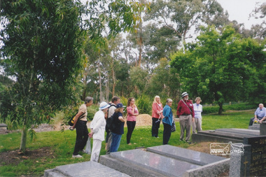
Photograph, Eltham Cemetery Tour, 13 Nov 2011
Eltham District Historical Society tour of Eltham Cemetery, led by EDHS President, Harry Gilham ELTHAM CEMETERY VISIT (EDHS Newsletter No. 201 November 2011) The Eltham Cemetery is the custodian of more than 150 years of Eltham's history. Harry Gilham's research on the cemetery includes information on Eltham pioneers from those early years, as well as details of interesting and important locals buried there in more recent times. Harry will lead a further tour of grave sites on Sunday 13th November. It will include many sites not visited on previous cemetery visits. The tour will start at 2.00 pm.Record of Socviety's history of excursionsIn black ink by hand Eltham District Historical Society Eltham Cemetery Tour Lead by Harry Gilham 13-11-11activities, eltham cemetery, eltham district historical society, harry gilham, heritage excursion, russell yeoman -
 Eltham District Historical Society Inc
Slide - Photograph, Blanche Shallard Tree, Local History Centre, 728 Main Road, Eltham, c.2004
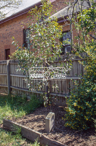
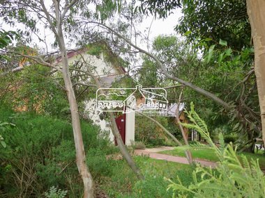
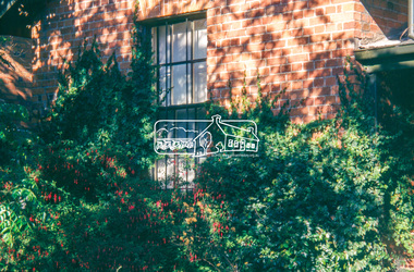
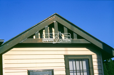
... Blanche Shallard Tree, Local History Centre, 728 Main Road...local history centre.... It was located in the garden to the rear of the Local History Centre.... It was located in the garden to the rear of the Local History Centre ...The Blanche Shallard tree was planted in honour of significant long time contributing member of the Shire of Eltham Historical Society/Elthamn District Historical Society. It was located in the garden to the rear of the Local History Centre beside the former Courthouse. Part of a presentation on "Significant Trees, Wildflowers and Local Gardens" by Russell Yeoman to the 10 November 2004 Eltham District Historical Society meeting35mm colour positive transparency Mount - white 7 dots (Technodia Italy)eltham, significant tree, blanche shallard, local history centre, main road -
 Eltham District Historical Society Inc
Film - Video (Digital), Peter Pidgeon, Eltham Local History Centre Through Time, 2018
... Eltham Local History Centre Through Time...local history centre...A slide show presentation of the Local History Centre... melbourne A slide show presentation of the Local History Centre ...A slide show presentation of the Local History Centre in commemoration of its 20th anniversaryMP4 Digital file 00:13:33; 798MBvideo recording, eltham district historical society, local history centre, 20th anniversary -
 Eltham District Historical Society Inc
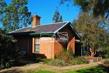
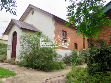
Photograph, Eltham Local History Centre, former Police Residence, 728 Main Road, Eltham, 2005
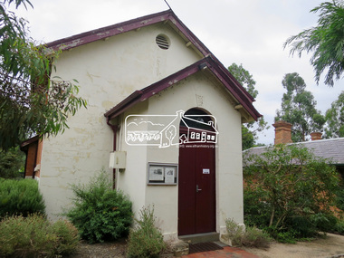
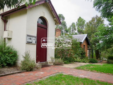
... Eltham Local History Centre, former Police Residence, 728...local history centre... Street Eltham District Historical Society local history centre ...Refurbishment of Police precinct at Eltham. Lock-up of 1880s. Facsimile of 1900s Police Station. Brick wall of residence built 1859.Colour photo print 15 x 10 cmeltham, 728 main road, activities, brougham street, eltham district historical society, local history centre, lockup -
 Eltham District Historical Society Inc
Photograph, Diamond Valley Leader, Eltham Local History Centre, former Police Residence, 728 Main Road, Eltham, 1998
... Eltham Local History Centre, former Police Residence, 728...local history centre... harry gilham justice precinct local history centre Leaser ...Members of the Eltham District Historical Society transfer collection items from storage into their new home. Previously occupied by the Parks and Environment Department of Nillumbik Shire Council (L-R: Mark Gillham, Margaret Ball Vice President, Sue Law Immediate Past President, Harry Gilham President) Nillumbik Shire Council Commissioner Vin Heffernan (1996-97) worked with Harry Gilham to obtain use of the former Eltham Shire Parks and Gardens office at 728 Main Road for use by the Society. Harry as a younger man had played in the scrum for Heidelberg Football Club along with Vin's brother who was on the wing. Apparently Heffernan was able to access $30K to spend on the site to fix it up for occupation.Colour photo print 12.5 x 19 cmLeaser Newspaper Groupmargaret ball, mark gilham, police residence, sue law, 728 main road, activities, eltham, eltham district historical society, harry gilham, justice precinct, local history centre -
 Eltham District Historical Society Inc
Photograph, Jim Connor, Main Road, Eltham, 3 Jul 2013
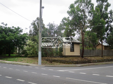
... local history centre...Former Police House (1859) and Local History Centre, 728... melbourne Former Police House (1859) and Local History Centre, 728 ...Former Police House (1859) and Local History Centre, 728 Main Road, ElthamTomorrow's history documented todayeltham, jim connor collection, local history centre, main road, police residence -
 Eltham District Historical Society Inc
Photograph, Jim Connor, Avenue of Honour, Main Road, Eltham, 14 Jan 2017
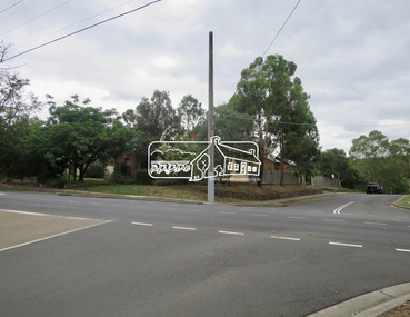
... local history centre... Station at Local History Centre... Station at Local History Centre Tomorrow's history documented ...Eltham Gateway, View looking north to intersection of Brougham Street from near 725 Main Road - replica former Police Station at Local History CentreTomorrow's history documented todayeltham, jim connor collection, main road, eltham gateway, avenue of honour, brougham steet, local history centre -
 Eltham District Historical Society Inc
Photograph, Jim Connor, Avenue of Honour, Main Road, Eltham, 14 Jan 2017
... local history centre...Eltham Gateway, Local History Centre, 728 Main Road, Eltham... melbourne Eltham Gateway, Local History Centre, 728 Main Road ...Eltham Gateway, Local History Centre, 728 Main Road, Eltham at intersection of Brougham Street Tomorrow's history documented todayeltham, jim connor collection, main road, eltham gateway, avenue of honour, brougham steet, local history centre -
 Eltham District Historical Society Inc
Photograph, Jim Connor, Avenue of Honour, Main Road, Eltham, 14 Jan 2017
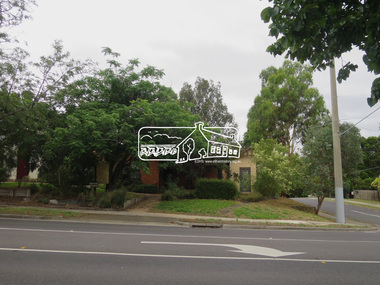
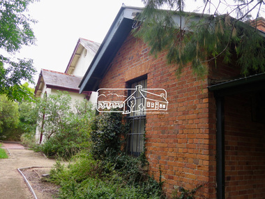
... local history centre... (1859) at 728 Main Road, Eltham - now part of the Local History... (1859) at 728 Main Road, Eltham - now part of the Local History ...Eltham Gateway, Eltham Justice Precinct featuring the former Eltham Courthouse (1860) at 730 Main Road, the oldest public building in the shire and the former Police Residence (1859) at 728 Main Road, Eltham - now part of the Local History Centre and home to Eltham District Historical SocietyTomorrow's history documented todayeltham, jim connor collection, main road, eltham gateway, eltham courthouse, eltham justice precinct, local history centre, police residence, avenue of honour -
 Eltham District Historical Society Inc
Photograph, Jim Connor, Avenue of Honour, Main Road, Eltham, 14 Jan 2017
... local history centre... (1859) at 728 Main Road, Eltham - now part of the Local History... (1859) at 728 Main Road, Eltham - now part of the Local History ...Eltham Gateway, Eltham Justice Precinct featuring the former Eltham Courthouse (1860) at 730 Main Road, the oldest public building in the shire and the former Police Residence (1859) at 728 Main Road, Eltham - now part of the Local History Centre and home to Eltham District Historical SocietyTomorrow's history documented todayeltham, jim connor collection, main road, eltham gateway, eltham courthouse, eltham justice precinct, local history centre, police residence, avenue of honour -
 Eltham District Historical Society Inc
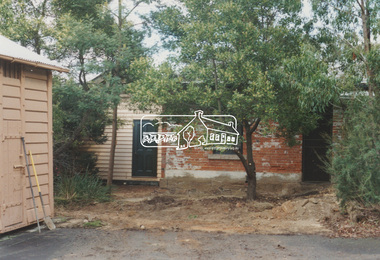
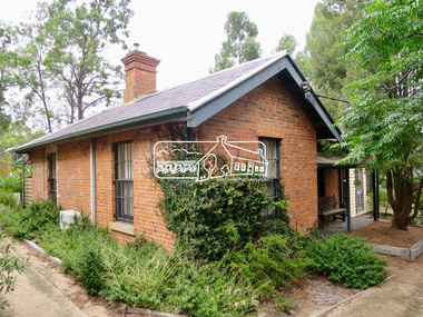
Slide - Photograph, 728 Main Road, cnr of Brougham Street, Eltham, May 1988, c.May 1988
... local history centre... as their Local History Centre.... as their Local History Centre. eltham infrastructure main road Brougham ...728 Main Road, cnr of Brougham Street, Eltham, May 1988. Former Police House (1859) which at time of photo was the offices of the Shire of Eltham Parks and Environment. This photo was taken prior to the building of the replica Police Station to serve as a lunch room. The origional timber weatherboard building had been relocated around the rear of the residence years earlier but had since been demolished due to termite infestation. Ten years later (1998) the residence was made available by Nillumbik Shire Council for occupation by the Eltham District Historical Society (former Shire of Eltham Historical Society) to be used as their Local History Centre.35mm colour positive transparency (1 of 36) Mount - Kodak KodachromeProcess Date MAY 88Meltham, infrastructure, main road, brougham steet, eltham justice precinct, local history centre, parks and environment, police residence, shire of eltham -
 Eltham District Historical Society Inc
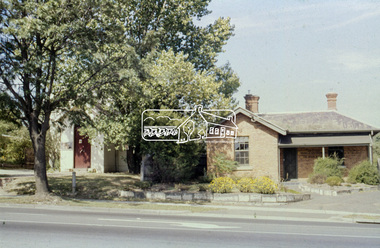
Slide - Photograph, Former Elltham Courthouse and Police Residence, c. Feb. 1989
... local history centre... and Local History Centre since 2008. ... and Local History Centre since 2008. 728 main road Eltham Eltham ...The bluestone blocks were originally part of the bluestone lockup located behind the Police Residence and Courthouse. The stones at one stage formed an edging to a grass island at the intersection of Wattletree Road and Main Road and were painted white. When that intersection was reconstructed the stones were brought back to the former residence, occupied by the Shire Department of Parks and Environement where again they were used as edging for a newly constructed driveway put through from Main Road through where the original Police Station was sited. The stones now form part of the garden bed edging at the rear of the building. At some stage in 1989 a reproduction Police Station was built beside the residence as originally located, for the purpose of providing a lunch room for shire staff. The residence has been the home of the Eltham District Historical Society and Local History Centre since 2008. 35mm colour positive transparency (1 of 8) Mount - Agfa CS System grey 8 dots728 main road, eltham, eltham courthouse, local history centre, police residence, parks and environment, shire of eltham -
 Eltham District Historical Society Inc
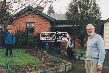
Slide - Photograph, Former Police Residence, Main Road, Eltham, c.1997
... local history centre... District Historical Society and Local History Centre... District Historical Society and Local History Centre Eltham Eltham ...Immediately prior to becoming the home of the Eltham District Historical Society and Local History Centre35mm colour positive transparency Mount - Black and Whiteeltham, eltham district historical society, local history centre, main road, police residence, police station -
 Eltham District Historical Society Inc
Slide - Photograph, Detail, Replica Police Station, Main Road, Eltham, c.1997
... local history centre... District Historical Society and Local History Centre... District Historical Society and Local History Centre eltham eltham ...Immediately prior to becoming the home of the Eltham District Historical Society and Local History Centre35mm colour positive transparency Mount - Black and Whiteeltham, eltham district historical society, local history centre, main road, police residence, police station -
 Eltham District Historical Society Inc
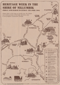
Booklet - Program, Shire of Nillumbik et al, Heritage Week in the Shire of Nillumbik, 2004
... hurstbridge local history group... intend to have open days at our Local History Centre on both days... intend to have open days at our Local History Centre on both days ...Map, with details of activitives presented by eight local history groups across the Shire of Nillumbik 26th March to Sunday 4th April 2004. Events included a dirt farming expo at Panton Hill. Program includes message by Mayor, Cr. Lex de Man and artwork by Syd Tunn. During the latter part of 2003 all of the historical societies and similar organisations in the Shire of Nillumbik attended a series of combined meetings arranged by Nillumbik Shire Council. The meetings were arranged by the Council's Arts and Cultural Services Co-ordinator and the Community Events Officer. ..The principal outcome of meetings ..to organise a Nillumbik Heritage Week to run from Friday 26th March to Sunday 4th April. The main event will be a combined heritage "expo" from 26th to 28th March, to be held in the Panton Hill Hall. The theme will be "Dirt Farming" which derives from the subsistence farming activities of the early settlers but could be widened to include gold mining, earth building and even modem day bushland regeneration. It fits well with the name "Nillumbik" which in the language of the Wurundjeri meant the not so good country covering most of our area and contrasted with the rich soil of the Kangaroo Grounds which they called Moor-rul. The following weekend each society will arrange their own separate activities. We intend to have open days at our Local History Centre on both days and this will include a display in the adjoining former Eltham Court House. We are also planning a heritage walk at 2.00pm on each day. Other groups will be having open days, displays, walks, guided car tours and other activities. - NL 154A3 sheet folded. Buff colour, with text and handrawn mapharry gilham collection, map, cultural heritage map, syd tunn, lex de man, eltham district historical society, nillumbik historical society, andrew ross museum, plenty historical society, st andrews queenstown historical society, warrandyte historical society, hurstbridge local history group -
 Eltham District Historical Society Inc
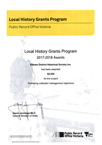
Document - Award Certificate, Local History Grants Program 2017-2018 Awards, Eltham District Historical Society; Public Record Office Victoria, 2018
... Local History Grants Program 2017-2018 Awards, Eltham...eltham district historical society, local history grants...Local History Grant issued to Eltham District Historical... melbourne Local History Grant issued to Eltham District Historical ...Local History Grant issued to Eltham District Historical Society to assist in furthering collection management objectives14 A4 pageseltham district historical society, local history grants program 2017-2018, public record office victoria (prov) -
 Eltham District Historical Society Inc
Photograph, Former Eltham Police Residence, 728 Main Road, Eltham, c.1985, 1985c
... 728 main road, eltham, local history centre, parks and... Residence and now present day Local History Centre, home to Eltham... Residence and now present day Local History Centre, home to Eltham ...This photo is believed to have been taken circa 1985 when the Shire of Eltham Parks and Environment occupied the site. This photo was originally mounted on 3mm MDF fibre board with notes and stickers applied as part of a display on the former Police Residence and now present day Local History Centre, home to Eltham District Historical Society; possibly put together by Harry Gilham during his time as president of the society. Eltham Police Station and Residence: A brief history 1860 Eltham Courthouse built in Main Road, together with an adjoining police residence, office, lock–up and stables. 1959 Police Department purchases a house in Pryor Street to be refurbished as Eltham Police Station 1961 Police in Eltham move into Pryor Street refurbished buildings and office. c.1961-1981 Occupied by Vermin and Noxious Weeds Destruction Section of the Department of Crown Lands and Survey. Former Police Station dragged around to rear of Police Residence (prior to August 1967) to make way for the construction of a driveway and access from Main Road. The building was placed on the site of a former Scullery and modified for Lands Department use. 1981 Shire of Eltham take over management of old Police Residence in Eltham. It remains unoccupied for a period of time whilst its future is discussed in Council. 1981-1985 Used for community job creation scheme 1985 Shire of Eltham Parks and Environment occupy the residence. Council improve the driveway but later add a second rear access from Brougham Street due to the dangerous nature of the Main Road entrance. Also add a rear toilet facility between the Police Residence and former Police Station, which was doubling up as a lunch room. Council also commence discussions to re-establish a replica Police Station. c.1986 November. Former Police Station demolished; believed to have been suffering termite damage. c.1989 After some years of discussion a replica Police Station is built, based on photographs, to act as a lunch room and meeting room for Parks and Environment staff and volunteers doing community service. 1996 Eltham District Historical Society in discussions with Nillumbik Shire Council commisioners throughout the year regarding a home for the Society. A proposal put forward by the Society in October to occupy the former Police Residence. 1997 March. Eltham District Historical Society gains access to former Police Residence. 1998 July 12th. Eltham District Historical Society Inc moves into its Local History Centre, 728 Main Road Eltham (the former Police Residnce built in 1860). 2018 July. Eltham District Historical Society gains access to the replica Police Station for use as part of regular heritage tours for schools and community based groups.Colour printHandwritten in faded blue felt pen ink "No. 3 - Front of 728 Police Residence. 1860 Court House over the paling fence. Verandah missing from earlier photographs"728 main road, eltham, local history centre, parks and environment, police residence, police station, shire of eltham -
 Eltham District Historical Society Inc
Photograph, Former Eltham Police Residence, 728 Main Road, Eltham, c.1985, 1985c
... 728 main road, eltham, local history centre, parks and... Residence and now present day Local History Centre, home to Eltham... Residence and now present day Local History Centre, home to Eltham ...This photo is believed to have been taken circa 1985 when the Shire of Eltham Parks and Environment occupied the site. This photo was originally mounted on 3mm MDF fibre board with notes and stickers applied as part of a display on the former Police Residence and now present day Local History Centre, home to Eltham District Historical Society; possibly put together by Harry Gilham during his time as president of the society. Eltham Police Station and Residence: A brief history 1860 Eltham Courthouse built in Main Road, together with an adjoining police residence, office, lock–up and stables. 1959 Police Department purchases a house in Pryor Street to be refurbished as Eltham Police Station 1961 Police in Eltham move into Pryor Street refurbished buildings and office. c.1961-1981 Occupied by Vermin and Noxious Weeds Destruction Section of the Department of Crown Lands and Survey. Former Police Station dragged around to rear of Police Residence (prior to August 1967) to make way for the construction of a driveway and access from Main Road. The building was placed on the site of a former Scullery and modified for Lands Department use. 1981 Shire of Eltham take over management of old Police Residence in Eltham. It remains unoccupied for a period of time whilst its future is discussed in Council. 1981-1985 Used for community job creation scheme 1985 Shire of Eltham Parks and Environment occupy the residence. Council improve the driveway but later add a second rear access from Brougham Street due to the dangerous nature of the Main Road entrance. Also add a rear toilet facility between the Police Residence and former Police Station, which was doubling up as a lunch room. Council also commence discussions to re-establish a replica Police Station. c.1986 November. Former Police Station demolished; believed to have been suffering termite damage. c.1989 After some years of discussion a replica Police Station is built, based on photographs, to act as a lunch room and meeting room for Parks and Environment staff and volunteers doing community service. 1996 Eltham District Historical Society in discussions with Nillumbik Shire Council commisioners throughout the year regarding a home for the Society. A proposal put forward by the Society in October to occupy the former Police Residence. 1997 March. Eltham District Historical Society gains access to former Police Residence. 1998 July 12th. Eltham District Historical Society Inc moves into its Local History Centre, 728 Main Road Eltham (the former Police Residnce built in 1860). 2018 July. Eltham District Historical Society gains access to the replica Police Station for use as part of regular heritage tours for schools and community based groups.Colour printHandwritten in faded blue felt pen ink "No. 2 - Backyard of 728 #5 Weatherboard 'Office'. Note 1860 Court House over the fence."728 main road, eltham, local history centre, parks and environment, police residence, police station, shire of eltham -
 Eltham District Historical Society Inc
Photograph, Former Eltham Police Residence, 728 Main Road, Eltham, c.1985, 1985c
... 728 main road, eltham, local history centre, parks and... Residence and now present day Local History Centre, home to Eltham... Residence and now present day Local History Centre, home to Eltham ...This photo is believed to have been taken circa 1985 when the Shire of Eltham Parks and Environment occupied the site. This photo was originally mounted on 3mm MDF fibre board with notes and stickers applied as part of a display on the former Police Residence and now present day Local History Centre, home to Eltham District Historical Society; possibly put together by Harry Gilham during his time as president of the society. Eltham Police Station and Residence: A brief history 1860 Eltham Courthouse built in Main Road, together with an adjoining police residence, office, lock–up and stables. 1959 Police Department purchases a house in Pryor Street to be refurbished as Eltham Police Station 1961 Police in Eltham move into Pryor Street refurbished buildings and office. c.1961-1981 Occupied by Vermin and Noxious Weeds Destruction Section of the Department of Crown Lands and Survey. Former Police Station dragged around to rear of Police Residence (prior to August 1967) to make way for the construction of a driveway and access from Main Road. The building was placed on the site of a former Scullery and modified for Lands Department use. 1981 Shire of Eltham take over management of old Police Residence in Eltham. It remains unoccupied for a period of time whilst its future is discussed in Council. 1981-1985 Used for community job creation scheme 1985 Shire of Eltham Parks and Environment occupy the residence. Council improve the driveway but later add a second rear access from Brougham Street due to the dangerous nature of the Main Road entrance. Also add a rear toilet facility between the Police Residence and former Police Station, which was doubling up as a lunch room. Council also commence discussions to re-establish a replica Police Station. c.1986 November. Former Police Station demolished; believed to have been suffering termite damage. c.1989 After some years of discussion a replica Police Station is built, based on photographs, to act as a lunch room and meeting room for Parks and Environment staff and volunteers doing community service. 1996 Eltham District Historical Society in discussions with Nillumbik Shire Council commisioners throughout the year regarding a home for the Society. A proposal put forward by the Society in October to occupy the former Police Residence. 1997 March. Eltham District Historical Society gains access to former Police Residence. 1998 July 12th. Eltham District Historical Society Inc moves into its Local History Centre, 728 Main Road Eltham (the former Police Residnce built in 1860). 2018 July. Eltham District Historical Society gains access to the replica Police Station for use as part of regular heritage tours for schools and community based groups.Colour printHandwritten in faded blue felt pen ink "Roof of room 5 (weatherboard office) and W.C. See No. 2 for another view"728 main road, eltham, local history centre, parks and environment, police residence, police station, shire of eltham -
 Eltham District Historical Society Inc
Photograph, Former Eltham Police Residence, 728 Main Road, Eltham, c.1985, 1985c
... 728 main road, eltham, local history centre, parks and... Residence and now present day Local History Centre, home to Eltham... Residence and now present day Local History Centre, home to Eltham ...This photo is believed to have been taken circa 1985 when the Shire of Eltham Parks and Environment occupied the site. This photo was originally mounted on 3mm MDF fibre board with notes and stickers applied as part of a display on the former Police Residence and now present day Local History Centre, home to Eltham District Historical Society; possibly put together by Harry Gilham during his time as president of the society. Eltham Police Station and Residence: A brief history 1860 Eltham Courthouse built in Main Road, together with an adjoining police residence, office, lock–up and stables. 1959 Police Department purchases a house in Pryor Street to be refurbished as Eltham Police Station 1961 Police in Eltham move into Pryor Street refurbished buildings and office. c.1961-1981 Occupied by Vermin and Noxious Weeds Destruction Section of the Department of Crown Lands and Survey. Former Police Station dragged around to rear of Police Residence (prior to August 1967) to make way for the construction of a driveway and access from Main Road. The building was placed on the site of a former Scullery and modified for Lands Department use. 1981 Shire of Eltham take over management of old Police Residence in Eltham. It remains unoccupied for a period of time whilst its future is discussed in Council. 1981-1985 Used for community job creation scheme 1985 Shire of Eltham Parks and Environment occupy the residence. Council improve the driveway but later add a second rear access from Brougham Street due to the dangerous nature of the Main Road entrance. Also add a rear toilet facility between the Police Residence and former Police Station, which was doubling up as a lunch room. Council also commence discussions to re-establish a replica Police Station. c.1986 November. Former Police Station demolished; believed to have been suffering termite damage. c.1989 After some years of discussion a replica Police Station is built, based on photographs, to act as a lunch room and meeting room for Parks and Environment staff and volunteers doing community service. 1996 Eltham District Historical Society in discussions with Nillumbik Shire Council commisioners throughout the year regarding a home for the Society. A proposal put forward by the Society in October to occupy the former Police Residence. 1997 March. Eltham District Historical Society gains access to former Police Residence. 1998 July 12th. Eltham District Historical Society Inc moves into its Local History Centre, 728 Main Road Eltham (the former Police Residnce built in 1860). 2018 July. Eltham District Historical Society gains access to the replica Police Station for use as part of regular heritage tours for schools and community based groups.Colour printHandwritten in faded blue felt pen ink "Another view of north wall 728 No. 4. Taken from west end towards back yard"728 main road, eltham, local history centre, parks and environment, police residence, police station, shire of eltham -
 Eltham District Historical Society Inc
Photograph, Former Eltham Police Residence, 728 Main Road, Eltham, c.1985, 1985c
... 728 main road, eltham, local history centre, parks and... Residence and now present day Local History Centre, home to Eltham... Residence and now present day Local History Centre, home to Eltham ...This photo is believed to have been taken circa 1985 when the Shire of Eltham Parks and Environment occupied the site. This photo was originally mounted on 3mm MDF fibre board with notes and stickers applied as part of a display on the former Police Residence and now present day Local History Centre, home to Eltham District Historical Society; possibly put together by Harry Gilham during his time as president of the society. Eltham Police Station and Residence: A brief history 1860 Eltham Courthouse built in Main Road, together with an adjoining police residence, office, lock–up and stables. 1959 Police Department purchases a house in Pryor Street to be refurbished as Eltham Police Station 1961 Police in Eltham move into Pryor Street refurbished buildings and office. c.1961-1981 Occupied by Vermin and Noxious Weeds Destruction Section of the Department of Crown Lands and Survey. Former Police Station dragged around to rear of Police Residence (prior to August 1967) to make way for the construction of a driveway and access from Main Road. The building was placed on the site of a former Scullery and modified for Lands Department use. 1981 Shire of Eltham take over management of old Police Residence in Eltham. It remains unoccupied for a period of time whilst its future is discussed in Council. 1981-1985 Used for community job creation scheme 1985 Shire of Eltham Parks and Environment occupy the residence. Council improve the driveway but later add a second rear access from Brougham Street due to the dangerous nature of the Main Road entrance. Also add a rear toilet facility between the Police Residence and former Police Station, which was doubling up as a lunch room. Council also commence discussions to re-establish a replica Police Station. c.1986 November. Former Police Station demolished; believed to have been suffering termite damage. c.1989 After some years of discussion a replica Police Station is built, based on photographs, to act as a lunch room and meeting room for Parks and Environment staff and volunteers doing community service. 1996 Eltham District Historical Society in discussions with Nillumbik Shire Council commisioners throughout the year regarding a home for the Society. A proposal put forward by the Society in October to occupy the former Police Residence. 1997 March. Eltham District Historical Society gains access to former Police Residence. 1998 July 12th. Eltham District Historical Society Inc moves into its Local History Centre, 728 Main Road Eltham (the former Police Residnce built in 1860). 2018 July. Eltham District Historical Society gains access to the replica Police Station for use as part of regular heritage tours for schools and community based groups.Colour printHandwritten in faded blue felt pen ink "Repeat view of No. 4 from external corner of weatherboard extn. Room 5"728 main road, eltham, local history centre, parks and environment, police residence, police station, shire of eltham -
 Eltham District Historical Society Inc
Photograph, Former Eltham Police Residence, 728 Main Road, Eltham, c.1985, 1985c
... 728 main road, eltham, local history centre, parks and... Residence and now present day Local History Centre, home to Eltham... Residence and now present day Local History Centre, home to Eltham ...This photo is believed to have been taken circa 1985 when the Shire of Eltham Parks and Environment occupied the site. This photo was originally mounted on 3mm MDF fibre board with notes and stickers applied as part of a display on the former Police Residence and now present day Local History Centre, home to Eltham District Historical Society; possibly put together by Harry Gilham during his time as president of the society. Eltham Police Station and Residence: A brief history 1860 Eltham Courthouse built in Main Road, together with an adjoining police residence, office, lock–up and stables. 1959 Police Department purchases a house in Pryor Street to be refurbished as Eltham Police Station 1961 Police in Eltham move into Pryor Street refurbished buildings and office. c.1961-1981 Occupied by Vermin and Noxious Weeds Destruction Section of the Department of Crown Lands and Survey. Former Police Station dragged around to rear of Police Residence (prior to August 1967) to make way for the construction of a driveway and access from Main Road. The building was placed on the site of a former Scullery and modified for Lands Department use. 1981 Shire of Eltham take over management of old Police Residence in Eltham. It remains unoccupied for a period of time whilst its future is discussed in Council. 1981-1985 Used for community job creation scheme 1985 Shire of Eltham Parks and Environment occupy the residence. Council improve the driveway but later add a second rear access from Brougham Street due to the dangerous nature of the Main Road entrance. Also add a rear toilet facility between the Police Residence and former Police Station, which was doubling up as a lunch room. Council also commence discussions to re-establish a replica Police Station. c.1986 November. Former Police Station demolished; believed to have been suffering termite damage. c.1989 After some years of discussion a replica Police Station is built, based on photographs, to act as a lunch room and meeting room for Parks and Environment staff and volunteers doing community service. 1996 Eltham District Historical Society in discussions with Nillumbik Shire Council commisioners throughout the year regarding a home for the Society. A proposal put forward by the Society in October to occupy the former Police Residence. 1997 March. Eltham District Historical Society gains access to former Police Residence. 1998 July 12th. Eltham District Historical Society Inc moves into its Local History Centre, 728 Main Road Eltham (the former Police Residnce built in 1860). 2018 July. Eltham District Historical Society gains access to the replica Police Station for use as part of regular heritage tours for schools and community based groups.Colour printHandwritten in faded blue felt pen ink "Backdoor to residence. White paint still visible 2010 on brickwork"728 main road, eltham, local history centre, parks and environment, police residence, police station, shire of eltham -
 Eltham District Historical Society Inc
Photograph, Former Eltham Police Residence, 728 Main Road, Eltham, c.1985, 1985c
... 728 main road, eltham, local history centre, parks and... Residence and now present day Local History Centre, home to Eltham... Residence and now present day Local History Centre, home to Eltham ...This photo is believed to have been taken circa 1985 when the Shire of Eltham Parks and Environment occupied the site. This photo was originally mounted on 3mm MDF fibre board with notes and stickers applied as part of a display on the former Police Residence and now present day Local History Centre, home to Eltham District Historical Society; possibly put together by Harry Gilham during his time as president of the society. Eltham Police Station and Residence: A brief history 1860 Eltham Courthouse built in Main Road, together with an adjoining police residence, office, lock–up and stables. 1959 Police Department purchases a house in Pryor Street to be refurbished as Eltham Police Station 1961 Police in Eltham move into Pryor Street refurbished buildings and office. c.1961-1981 Occupied by Vermin and Noxious Weeds Destruction Section of the Department of Crown Lands and Survey. Former Police Station dragged around to rear of Police Residence (prior to August 1967) to make way for the construction of a driveway and access from Main Road. The building was placed on the site of a former Scullery and modified for Lands Department use. 1981 Shire of Eltham take over management of old Police Residence in Eltham. It remains unoccupied for a period of time whilst its future is discussed in Council. 1981-1985 Used for community job creation scheme 1985 Shire of Eltham Parks and Environment occupy the residence. Council improve the driveway but later add a second rear access from Brougham Street due to the dangerous nature of the Main Road entrance. Also add a rear toilet facility between the Police Residence and former Police Station, which was doubling up as a lunch room. Council also commence discussions to re-establish a replica Police Station. c.1986 November. Former Police Station demolished; believed to have been suffering termite damage. c.1989 After some years of discussion a replica Police Station is built, based on photographs, to act as a lunch room and meeting room for Parks and Environment staff and volunteers doing community service. 1996 Eltham District Historical Society in discussions with Nillumbik Shire Council commisioners throughout the year regarding a home for the Society. A proposal put forward by the Society in October to occupy the former Police Residence. 1997 March. Eltham District Historical Society gains access to former Police Residence. 1998 July 12th. Eltham District Historical Society Inc moves into its Local History Centre, 728 Main Road Eltham (the former Police Residnce built in 1860). 2018 July. Eltham District Historical Society gains access to the replica Police Station for use as part of regular heritage tours for schools and community based groups.Colour printHandwritten in faded blue felt pen ink "No. 1 South wall of 728 & back of house built 1860 [1859]. Demolition of weatherboard extension into yard area"728 main road, eltham, local history centre, parks and environment, police residence, police station, shire of eltham -
 Eltham District Historical Society Inc
Photograph, View looking up 'Policeman's Hill' on Main Road from Dalton Street showing Police Residence, c.1906, 2010c
... 728 main road, eltham, local history centre, parks and... and now present day Local History Centre, home to Eltham District... and now present day Local History Centre, home to Eltham District ...For original image see EDHS_00533 This photo was originally mounted on 3mm MDF fibre board with notes and stickers applied as part of a display on the former Police Residence and now present day Local History Centre, home to Eltham District Historical Society; possibly put together by Harry Gilham during his time as president of the society. Eltham Police Station and Residence: A brief history 1860 Eltham Courthouse built in Main Road, together with an adjoining police residence, office, lock–up and stables. 1959 Police Department purchases a house in Pryor Street to be refurbished as Eltham Police Station 1961 Police in Eltham move into Pryor Street refurbished buildings and office. c.1961-1981 Occupied by Vermin and Noxious Weeds Destruction Section of the Department of Crown Lands and Survey. Former Police Station dragged around to rear of Police Residence (prior to August 1967) to make way for the construction of a driveway and access from Main Road. The building was placed on the site of a former Scullery and modified for Lands Department use. 1981 Shire of Eltham take over management of old Police Residence in Eltham. It remains unoccupied for a period of time whilst its future is discussed in Council. 1981-1985 Used for community job creation scheme 1985 Shire of Eltham Parks and Environment occupy the residence. Council improve the driveway but later add a second rear access from Brougham Street due to the dangerous nature of the Main Road entrance. Also add a rear toilet facility between the Police Residence and former Police Station, which was doubling up as a lunch room. Council also commence discussions to re-establish a replica Police Station. c.1986 November. Former Police Station demolished; believed to have been suffering termite damage. c.1989 After some years of discussion a replica Police Station is built, based on photographs, to act as a lunch room and meeting room for Parks and Environment staff and volunteers doing community service. 1996 Eltham District Historical Society in discussions with Nillumbik Shire Council commisioners throughout the year regarding a home for the Society. A proposal put forward by the Society in October to occupy the former Police Residence. 1997 March. Eltham District Historical Society gains access to former Police Residence. 1998 July 12th. Eltham District Historical Society Inc moves into its Local History Centre, 728 Main Road Eltham (the former Police Residnce built in 1860). 2018 July. Eltham District Historical Society gains access to the replica Police Station for use as part of regular heritage tours for schools and community based groups.Black and white photocopyLabels and handwriting in pencil and ink identifying various buildings. Also highlighted is the acetylene gas lamp and on reverse is written "Lamplighter Jimm Saville"728 main road, eltham, local history centre, parks and environment, police residence, police station, shire of eltham -
 Eltham District Historical Society Inc
Folder, Notes for talk on the History of Eltham by Harry Gilham, 1997
... in the 1950s. Notes on discussion on what is local history... in the 1950s. Notes on discussion on what is local history ...Folder includes letter confirming invitation to speak at the Probus Club of Montmorency. A list of community groups, charity funds and other organisations operating in the Shire of Eltham in the 1950s. Notes on discussion on what is local history and reference to local places including bridges and examples of change of names and meanings of place names10 pages, 9 of handwritten notesHG Booklet 18harry gilham collection, shire of eltham, community groups, harry gilham