Showing 3174 items
matching history railways
-
 Glenelg Shire Council Cultural Collection
Photograph - Photograph - Aerial Photo railway line between Heywood and Rennick, 03/05/1952
Victorian Railways aerial survey record print of the railway line between Heywood and Rennick (S.A. border) Black and white, white vertical strip on imageBack: 'Heywood - Rennick 21384 - 19655 260m 46c Heywood' - all black ink. Purple VR aerial survey stamp. '3 May 1952' - black stamp -
Glenelg Shire Council Cultural Collection
Photograph - aerial view of train track between Heywood and Rennick, 03/05/1952
Black and white aerial photographs (aerial survey record print) of the railway line between Heywood and Rennick (S.A. border) Taken for Victorian Railways, May 1952. Some photos have annotations later added to the front of the image in penVictorian Railways aerial survey record print of the railway line between Heywood and Rennick (S.A. border) Black and white, white vertical strip on imageFront: Annotations in red ink added at a later date Back: 'Heywood - Rennick 21578 - 19841 279m 49c Rennick ' - all black ink. Purple VR aerial survey stamp. '3 May 1952' - black stampvictorian railways, train track, travel, transport -
Glenelg Shire Council Cultural Collection
Photograph - Photograph - aerial view of railway line between Heywood and Rennick, 03/05/1952
Victorian Railways aerial survey record print of the railway line between Heywood and Rennick (S.A. border) Black and white, white vertical strip on imageBack: 'Heywood - Rennick 21450 - 19721 266m 72 c' - all black ink. White sticker, black print 'Marp' Purple VR aerial survey stamp. '3 May 1952' - black stampvictorian railways, aerial photography -
Glenelg Shire Council Cultural Collection
Photograph - Photograph - aerial view of the train track between Heywood and Rennick, 03/05/1952
Black and white aerial photographs (aerial survey record print) of the railway line between Heywood and Rennick (S.A. border) Taken for Victorian Railways, May 1952. Some photos have annotations later added to the front of the image in penVictorian Railways aerial survey record print of the railway line between Heywood and Rennick (S.A. border) Black and white, white vertical strip on imageFront: Annotations in red ink added at a later date Back: 'Heywood - Rennick 21577 - 19840 279m 41c ' - all black ink. White sticker, black print 'Rennick' Purple VR aerial survey stamp. '3 May 1952' - black stampvictorian railways, travel, train, transport -
Glenelg Shire Council Cultural Collection
Photograph - Photograph - aerial view of train track between Heywood and Rennick, 03/05/1952
Black and white aerial photographs (aerial survey record print) of the railway line between Heywood and Rennick (S.A. border) Taken for Victorian Railways, May 1952. Some photos have annotations later added to the front of the image in penVictorian Railways aerial survey record print of the railway line between Heywood and Rennick (S.A. border) Black and white, white vertical strip on imageBack: 'Heywood - Rennick 21453 - 19724 267m 19c ' - all black ink. Purple VR aerial survey stamp. '3 May 1952' - black stampvictorian railways, train track, transport, travel -
Glenelg Shire Council Cultural Collection
Photograph - Aerial Survey Railway Record Print – 1952, 03/05/1952
Victorian Railways aerial survey record print of the railway line between Heywood and Rennick (S.A. border) Black and white, white vertical strip on image.Back: 'Heywood - Rennick 21531 - 19794 274m 18c ' - all black ink. Purple VR aerial survey stamp. '3 May 1952' - black stamp -
Glenelg Shire Council Cultural Collection
Photograph - Aerial Survey Railway Record Print – 1952, 03/05/1952
Victorian Railways aerial survey record print of the railway line between Heywood and Rennick (S.A. border) Black and white, white vertical strip on image.Back: 'Heywood - Rennick 21386 - 19657 260m 61c Heywood' - all black ink. Purple VR aerial survey stamp. '3 May 1952' - black stamp -
Glenelg Shire Council Cultural Collection
Negative - Negative - Portland, Victoria, Zilah Maschmedt, c. 1934
Negative for a black and white photograph. Image taken from Henty Beach, looking toward Ocean Pier, bathing shed, pier (the Slip) in foreground, Railway Pier, and Ocean Pier. -
Glenelg Shire Council Cultural Collection
Booklet - Booklet - South Western Victoria, n.d
Forty-two page tourist brochure of South Western Victoria, produced by Victorian Railways. Contains black and white photos of cities and towns in the south west with a short description of each. Centre page full colour map of area. Blue cover, red print, image of man in bathers on a beach.Front: 'B.W. Vivian', ink, faded -
Glenelg Shire Council Cultural Collection
Flyer - Flyer - Portland, Victoria, Oct-38
Single page flyer, folded 4 times. Tourist information for Portland, issued by Publicity and Tourist Services, Victorian Railways. Contains several black and white photos of Portland, front cover red print, blue stylised bird and sea. Back cover has tourist map of Portland and District -
Glenelg Shire Council Cultural Collection
Photograph - Photograph - Portland Harbour, n.d
Black and white photo, looking north over railway station to Lighthouse Bluffportland harbour, whalers bluff, portland lighthouse -
Glenelg Shire Council Cultural Collection
Photograph - Photograph - Portland, Victoria, n.d
Black and white photo looking from shore across to Battery Point. Baths, Ocean Pier, Railway Pier, Fishermen's Breakwater, 3 fishing boats under sail. Portland VictoriaBack: '56' in pencil -
Glenelg Shire Council Cultural Collection
Photograph - Photograph - Portland Harbour Early Shipping - Ocean / Railway Pier, n.d
Port of Portland Authority ArchivesBack: 'The Shell Co of Aust. Opening of Portland Installation July 20th, 1929 ' in pencilport of portland archives, ship berthed, portland harbour -
Glenelg Shire Council Cultural Collection
Photograph - Photograph - Early Shipping: Ocean / Railway Pier, 07/11/1923
Port of Portland Authority ArchivesFront: White lettering on photo: 'DALGETY & CO SHIPPING WOOL AT PORTLAND 7.11.23' Back: Purple stamp - 'PORTLAND HARBOR TRUST COMMISSIONERS' '(7) Blue biroport of portland archives, ocean pier -
Glenelg Shire Council Cultural Collection
Postcard - Postcard - Storm of 1923, Portland Harbour Victoria, c. 1923
Black and white photo postcard, taken during the storm of 1923. Man on Railway Pier, walking towards shore; big waves between Railway Pier and Fishermen's Breakwater, waves breaking over Fishermen's Breakwater -
 Glenelg Shire Council Cultural Collection
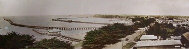
Mixed media - Photocard - Colour Panorama, Portland Bay, Colour Panorama, Portland Bay, n.d
Displayed at History HouseTinted photo. Baths with blue roof in foreground. Fisherman's Wharf in background, Long Pier, Railway Pier, and Cypress Trees along Bentinck Street. Telegraph Poles along Street. Truck carrying bales. Mounted on cardboard.Front: Panorama of Portland, Victoria (Length of Ocean Pier, 2880 ft). -
Glenelg Shire Council Cultural Collection
Booklet - Brochure - Promoting Portland, Victoria, Victorian Railways Print, Oct-38
Brochure promoting Portland, folds out to A3 printed on light card. Front cover, white and blue stylised sky with sea and a seabird. 'PORTLAND, VICTORIA, AUSTRALIA' -printed in red. Back cover, black line map with roads marked in orange. Black and white photos of harbour, Dutton Beach, Gardens cottage, Henty Beach, 'Burswood', Henty Memorial, plus printed information about Portland and district.portland -
Glenelg Shire Council Cultural Collection
Flyer - Flyer - Casterton focus of the South West, Victoria, c. 1987
DL flyer, tri-fold. Brochure advertising Casterton. Pale grey, red print, sepia photos. Illustration on front of Casterton Railway Station, signed 'Paul Astbury 1987'. Advertisements in 8156, 8157 are the same, but some of the photos are different. -
Glenelg Shire Council Cultural Collection
Photograph - Photograph - Portland, Victoria, c. 1940
Black and white photo from Whaler's Bluff, looking south. Nun's Beach, baths, Ocean Pier, Railway Pier, Henty Beach, Battery PointBack: 'The Beach and Piers, Portland' - black print -
Glenelg Shire Council Cultural Collection
Negative - Negative - Portland Baths Victoria, Zilah Maschmedt, c. 1934
Negative for a black and white photograph. Image shows Side-on view of Baths at Portland, taken from Railway Pier. Whaler's Bluff in background. -
Glenelg Shire Council Cultural Collection
Negative - Negative - Portland, Victoria, Zilah Maschmedt, c. 1934
Negative for a black and white photograph. Photo taken from grass track near beach at Portland, looking across harbour. Baths, Ocean Pier, Railway Pier, Fishermen's Breakwater and Henty Beach. -
Glenelg Shire Council Cultural Collection
Booklet - Booklet - The Seaside Calls, n.d
Sixteen page booklet, issued by Victorian Railways Publicity and Tourist Services, Melbourne. Information on Victorian seaside towns, from Mallacoota Inlet on the east to the South Australian border in the west.Front: 'VIVIAN' - handwritten, biro, top right. -
Glenelg Shire Council Cultural Collection
Negative - Negative - Portland Centenary Celebrations, 1934
A collection of 47 negatives of photographs of Portland taken by Zillah Maschmedt. Most were taken in 1934 during the centenary celebrations for Portland. Zillah was a school teacher in Mount Gambier.NEGATIVE FOR BLACK AND WHITE PHOTOGRAPH. Boat playing part of 'Thistle' at centenary of Henty's landing anchored off Railway Pier. Photo taken from shore. Bunting on ship's rigging and along pier.zillah maschmedt, 1934, centenary celebrations, henty, portland harbour -
Glenelg Shire Council Cultural Collection
Negative - Negative - Portland Harbour, Victoria, Zilah Maschmedt, c. 1934
Negative for a black and white photograph. Image shows Portland Harbour, looking east. Ocean Pier, Railway Pier. Vessel playing the part of Henty's 'Thistle' at centenary of landing, anchored off Railway Pier, bunting on rigging. -
Glenelg Shire Council Cultural Collection
Negative - Negative - View from Henty Beach lawns Portland, Victoria, Zilah Maschmedt, c. 1934
Negative for a black and white photograph. Image shows view from Henty Beach lawns, looking towards Whaler's Bluff. Beach shelters, samd,, Railway Pier, Baths, Ocean Pier, lighthouse and water tower on Whaler's Bluff. -
Glenelg Shire Council Cultural Collection
Flyer - Flyer - Victorian Railways, Mar-71
DL flyer, produced by Victorian Railways, issued March 1971, 'Know your Railways', re economics of building a Litchfield-Minyip rail link -
Glenelg Shire Council Cultural Collection
Flyer - Flyer - Brochure Casterton, Victoria, Casterton focus of the South West, c. 1987
DL flyer, tri-fold. Brochure advertising Casterton. Pale mauve, red print, black and white photos. Illustration on front of Casterton Railway Station, signed 'Paul Astbury 1987'. Advertisements in 8156, 8157 are the same, but some of the photos are different. -
Glenelg Shire Council Cultural Collection
Photograph - Aerial Survey Railway Record Print – 1952, 03/05/1952
Victorian Railways aerial survey record print of the railway line between Heywood and Rennick (S.A. border) Black and white, white vertical strip on image.Back: 'Heywood - Rennick 21080 - 19371 235m 75c Heywood' - all black ink. Purple VR aerial survey stamp. '3 May 1952' - black stamp -
Glenelg Shire Council Cultural Collection
Photograph - Aerial Survey Railway Record Print - 1952, 03/05/1952
These photos were found in a car that was left for recycling.Victorian Railways aerial survey record print of the railway line between Heywood and Rennick (S.A. border) Black and white, white vertical strip on image.Front: 'to Rennick, Heywood from Melbourne' in the white strip Back: 'Heywood - Rennick 21069 - 19360. 235m31c Heywood' - all black ink. Purple VR aerial survey stamp. '3 May 1952' - black stamp -
Glenelg Shire Council Cultural Collection
Photograph - Aerial Survey Railway Record Print – 1952, 03/05/1952
Victorian Railways aerial survey record print of the railway line between Heywood and Rennick (S.A. border) Black and white, white vertical strip on image.Back: 'Heywood - Rennick 21221 - 19502 248m 8c Heywood Lyons' - all black ink. Purple VR aerial survey stamp. '3 May 1952' - black stamp