Showing 984 items matching "homestead."
-
 Glenelg Shire Council Cultural Collection
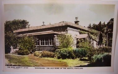
Postcard - Postcard - 'Burswood', The Old Home of the Hentys, Portland, Rose Stereograph Col Armadale, Victoria, 'Burswood', The Old Home of the Hentys, Portland, n.d
Displayed at History House.Coloured postcard of Burswood Homestead showing front and one side.Front: The Rose Series P10799 Copyright. 'Burswood', The Old Home of the Hentys, Portland. Back: The 'Rose' Series Deluxe. A real photograph. Produced in Australia. Published by the Rose Stereograph Col Armadale, Victoria. -
 Robin Boyd Foundation
Slide, Robin Boyd
Colour slide in a mount. Bluestone homestead, Western District, VictoriaMount Made in Englandslide, robin boyd -
 Stawell Historical Society Inc
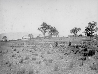
Photograph, Ledcourt Home Station in the Grampians 1866
Ledcourt Home Station Grampians. Part of a collection of Photographs by Mr. O.G. Armstrong as commissioned by the Shire of Stawell for the Inter-colonial and Paris Exhibition in Melbourne in 1866. This was one of, if not the first, Squatters Sheep Station in this region. The first licence of Ledcourt was granted to Robert Briggs in about 1840. In 1842 the run passed to Benjamin Boyd of Whaling and Boydtown Banking fame in NSW. He held it for six years. It was then taken over by Thomas Young and John Carfrae, who divided it into 3 holdings. Ledcourt 74,500 acres, Newington 74,500 acres and Swinton, 52,000 acres. It again changed hands in 1859, this time to Henry Alfred and Joseph De Little. It has changed hands several times since and in later years owned by the Cooper family and now the Marr family. The date of the actual building is uncertain, but it is known that the stone used in the building was carted from the Mount Difficult area in the Grampians and some of the courtyard paving shows convict origin. Looking up hill with Homestead on left and stone stables or right.stawell -
 Sunbury Family History and Heritage Society Inc.
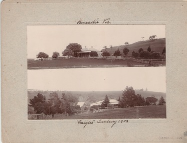
Photograph, Vineyards - Ben Eadie and Craiglee, 1903
The two homesteads are Ben Eadie and Craiglee, which were two of Sunbury's earliest vineyards that were established in Sunbury. James Stewart Johnson designed and built his concrete home, Craiglee, in 1865 where the previous year he had planted out his vineyard on the surrounding 26 acres of land.The property was on the east side of Jacksons Creek on Macedon Road. He concentrated growing Riesling and Hermitage grapes. After his death in 1896, his son Wilfred continued to produce wines until the late 1920s, when he pulled out the vines and concentrated on raising sheep for wool and meat. The Carmody family purchased the property in 1961 and in 1976 decided to replant the vineyard. Ben Eadie was built some time in 1863 and settled by the Eadie family who also were millers. The winery was built into the side of a hill close to the house but the Eadie family tended to concentrate on milling and retailing.In the earliest days of European settlement many wineries were established in the Sunbury area.Two non-digital sepia photographs have been mounted on cardboard. They are photographs of two homesteads with bare hills in the background. They were built in Sunbury in the early days off European settlementBen Eadie Vic. Craiglee Sunbury 1903john eadie, ben eadie winery, james stewart johnson, craiglee, wineries, vineyards -
 Phillip Island and District Historical Society Inc.
Photograph
Part of collection of Photographs donated to the Museum by the family of the late Mr. Jack Jenner. (1977)Black & White Photograph of Churchill IslandChurchill Island - Back of Old Homestead 4/11/'68local history, photography, photographs, slides, film, view churchill island, black & white photograph, jack jenner, churchill island, phillip island -
 Linton and District Historical Society Inc
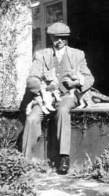
Photograph, Rex Bell
Black and white copy of photograph of Rex Bell wearing flat hat, pipe in mouth, nursing two cats, seated on verandah floor."Rex Bell sitting out the front of Emu Hill Homestead".rex bell, emu hill homestead, cats -
 Bendigo Historical Society Inc.
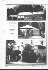
Photograph - RAVENSWOOD CROWN LANDS
3 x black and white Photographs,- photocopy of page 34 of Bendigo Its Environs - The Way It Was - Ravenswood Crown Lands, three views at the Ravenswood Homestead c2003. Wool shed, Chapel ,Homestead.photograph, building, house -
Glenelg Shire Council Cultural Collection
Flyer - Flier - 'Warrock' Homestead, Casterton, n.d
DL flyer, glossy paper, black and white, 'Warrock' Homestead, Casterton -
 Ringwood and District Historical Society
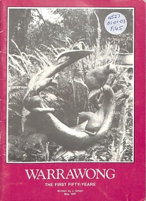
Book, Warrawong - The First Fifty Years, 1987
50 year history of Warrawong Homestead, East Ringwood, published 1987j.b. were, ware homestead, fred davey -
 Tatura Irrigation & Wartime Camps Museum
Book, The Fenton Hall Story, 2007
A documentary record of a Harston family and farm 1903-2003. Contains family tree and photographsCream cover, black lettering. Photograph of Fenton Hall homestead on frontthe fenton hall story, crawford family, fenton hall, tatura, crawford families, books, history, local -
 Stawell Historical Society Inc
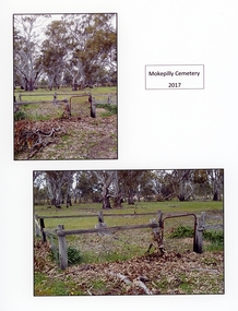
Photograph, Dorothy Brumby, Mokepilly Cemetery 2017
Located at Illawarra near the Homestead. Taken in 2017. Two Colour photographs.Mokepilly Cemetery 2017 -
 Melton City Libraries
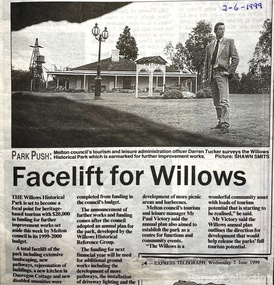
Newspaper, Facelift for the Willows, 1999
Works being undertaken at the Willows Homestead article featured in the Express Telegraph local architecture, council, local special interest groups -
 Lakes Entrance Historical Society
Photograph - Homestead Fraser Island, Buckland, 1942 c
Black and white photograph of Fraser Island Homestead, Gippsland Lakes, Victoria.houses, accommodation, tourism -
 Stawell Historical Society Inc
Photograph, ''Mokebilla" Station 1866
Mokebilla Station. Part of a collection of Photographs by Mr. O.G. Armstrong as commissioned by the Shire of Stawell for the Inter-colonial and Paris Exhibition in Melbourne in 1866. Charles Browning Hall was at the station for a short period in about 1840-41. Horatio Wils purchased Lexington from C.B. Hall in 1842. To this he added the stations of Larose and Mokebilla. Part of the property still remains along the Halls Gap Rd, by the bridge over the Mount William Creek. Note that the spelling has changed over the years and it is currently known as Mokepilly. Looking across water to Homestead and outbuildings behind large Gum Trees.stawell -
Glenelg Shire Council Cultural Collection
Flyer - DL Flyer - Warrock Homestead Casterton, n.d
DL flyer, black and white, single fold, advertising 'Warrock' homestead at CastertonFront: 'B. VIVIAN', handwritten blue biro. Red stamp 'RACV ACCOMMODATION BOOKING 123 Queen St MELBOURNE PHONE 600251' -
 Whitehorse Historical Society Inc.
Photograph, Pioneer's House, S.W. Corner of Canterbury and Heatherdale Roads, 1987-88
Pioneer's House on Subdivision - Homestead Rise: S.W. Corner of Canterbury and Heatherdale Roads.pioneer's house, homestead rise subdivision, canterbury road mitcham, heatherdale road mitcham -
Ballarat Heritage Services
Photograph, Clare Gervasoni, Brookside Farm Looking Towards the Creek, 21/01/2021
A video of Brookside Homestead looking towards the Creek, taken from the public roadway.brookside, farm, homestead -
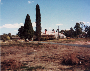
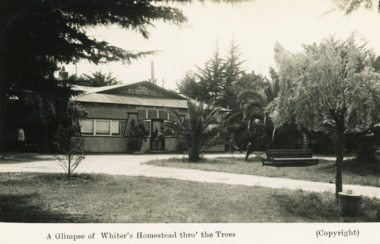 Lakes Entrance Historical Society
Postcard - Whiters Homestead, H D Bulmer, 1940 c
Black and white postcard of the Homestead at Whiters Camp Park Lakes Entrance VictoriaA Glimpse of Whiters Homestad thro the treesparks, businesses, houses -
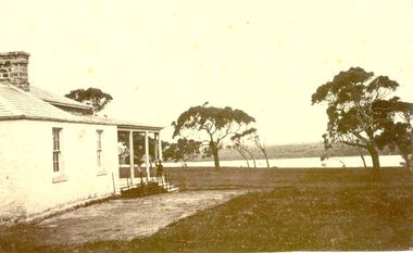
 Glenelg Shire Council Cultural Collection
Photograph - Photograph - homestead, 1920, 1920
Photographs taken by Esther Winifred Hall (nee Smallpage) - great grand-daughter of Stephen George Henty. Taken in 1934 Centenary Celebrations in Portland.Black and white photograph showing house with wide verandah of three visible sides, behind light-coloured post and wire fence with a metal gate.Front: (no inscriptions) Back: Homestead 1920. Now all creepers and trees.esther winifred hall, photography, henty, portland centenary, 1934 -
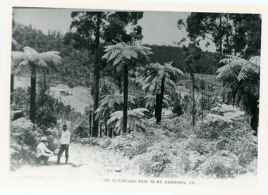 Mt Dandenong & District Historical Society Inc.
Photograph, View From Doughty's Road 1913
Mt Calvin, the homestead of Jeanie and Willie Richardson can be clearly seen in the clearing above the men in the picture. The white roof of the Barber homestead is on the right of the picture. A landslide in 1934 destroyed the tree ferned area. John Lundy-Clarke grew up in the Kalorama/Mt Dandenong area and later in life (1972-74) began to write a comprehensive history of the area working from an original settlement map in an effort to cover all areas.Black and white photograph that is a copy of a Rose series postcard titled 'The Picturesque Road to Mt. Dandenong. Vic.' It shows two men (probably Rose Series employees), one sitting and one standing at the edge of an unmade road. Large tree ferns line the roadside. Handwritten inscription on reverse by John Lundy-Clarke1913 View east from Doughty’s Road showing Jeannie Richardson’s home through the gap in the trees. A little to the right of and below centre of picture can be seen George Barber’s home with Barbers Road turning around the wagon shed that was a little up the hill from the house. The tree ferns in the picture were destroyed in the landslide of 1934. In the distance at the right can be seen F.M. Childs Homestead complex with the Richardson paddocks beyond it.mt calvin, jeanie richardson, willie richardson, george barber, landslide, tree fern -
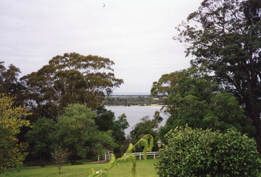 Lakes Entrance Historical Society
Photograph - Fraser Island, Holding M, 2000c
Colour photograph taken from the veranda of Nyerimilang Homestead, Gippsland Lakes. It shows a glimpse of Fraser Island through the trees and ornamental shrubs of the homestead garden. Fence and pathway to viewing platform in centre foreground. Lakes Entrance Victoriaislands, historic site -
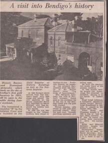 Bendigo Historical Society Inc.
Newspaper - NEWSPAPER ARTICLE: A VISIT INTO BENDIGO'S HISTORY
Newspaper article 'A visit into Bendigo's history ' The Historic Ravenswood Homestead. A photo of the buildings is shownnewspaper, historic ravenswood homestead -
Tatura Irrigation & Wartime Camps Museum
Book, The Fenton Hall Story, 2007
A documentary record of a Harston family and farm 1903-2003. Contains family tree and photographsCream cover, black lettering. Photograph of Fenton Hall homestead on front. 113 pagesthe fenton hall story, fenton hall, crawford family history, tatura, crawford families, books, history, local -
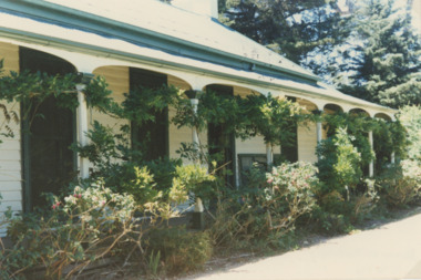
 Ballarat Heritage Services
Photograph, Clare Gervasoni, Gates into Brookside Farm, 21/01/2021
A photograph and two videos showing the gates into Brookside Homestead taken from the public roadway.brookside, farm, stable -
 Port Fairy Historical Society Museum and Archives
Photograph
Boodcarra - I Ritchie EsqBlack and white photograph of side wall of Boodcarra homestead and view to the Goose Lagoon Swampboodcarra, i ritchie esq -
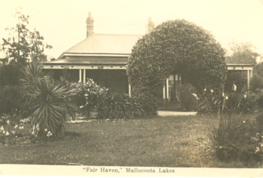 Lakes Entrance Historical Society
Postcard - Fair Haven, Mallacoota Victoria, 1920 c
Fair Haven was one of the earliest settlements on the Mallacoota lakes, it was run as a guesthouse for some yearsBlack and white postcard of homestead known as Fair Haven situated on the lake at Mallacoota Victoriasettlement, historic buildings -
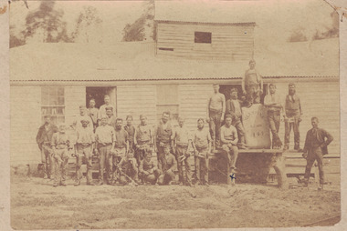 Linton and District Historical Society Inc
Photograph, 'Glenfine' Shearing Shed, 1890
In July 1840, Glenfine, consisting of 31,440 acres, was acquired by Thomas Downie. In March 1842 the 'Right of Run' was taken up by Thomas Chirnside who with an imported stallion 'Delapre' ran a horse stud. He apparently lived here for ten years and employed a gardener with a wife and five children from Hobart, Tasmania. Only some blocks of stone and a few trees remain of their homestead. In 1853 the property was transferred to Dr. John Chirnside, an elder brother of Thomas Chirnside. In 1857, William Rowe of Naringal purchased Glenfiine where he and his family lived until 1904 when it was bought by Richard Howell's estate. It was then 39,000 acres. The present house was built by the Rowes in 1872 of bluestone quarried on the property with a cement render overall. The architect was H.R. Casselli. Gold was found on the property and by 1898 the township of Hollybush was first reported, situated at either side of the front entrance, on the Cressy Road. The land for the township was given by William Rowe. In 1911 R.C. Howell, son of Richard Howell, became the owner, followed by his son in 1960. By 1990 Hollybush had a population of 426 persons. All of the early history of Glenfine, documents etc., were destroyed when Naringal homestead was burnt down in 1944. Glenfine was classified by the National Trust in 1974 and is on the Heritage Commission Register. Mounted black and white image of a large group of men and boys in front of a weatherboard shearing shed. The men are each holding a pair of hand shears. One young man is kneeling on top of a wool bale. A small blue biro 'x' identifies W. Todd. Glenfine was a pastoral station, and the original homestead still stands.shearing sheds, shearers, rural activity, william todd, glenfine pastoral station, thomas chirnside, thomas downie, richard howell, william thomas rowe -
 Lakes Entrance Historical Society
Photograph - Strathfieldsaye Homestead, Lake Wellington Gippsland Victoria, 1/12/1987 12:00:00 AM
Colour photograph showing the front verandah wisteria vine and garden at Strathfieldsaye Homestead taken up by William O'Dell Raymond in 1942 on Lake Wellington Gippsland Victoria. Also three colour photographs taken at same time of Strathfieldsaye Homestead agriculture, houses -
 Bendigo Historical Society Inc.
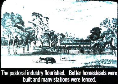
Slide - DIGGERS & MINING. THE GOLD ERA, c1850s
BHS CollectionDiggers & mining. The gold era. The pastoral industry flourished. Better homesteads were built and many stations were fenced. Slide shows some of the fencing and shelters added to homesteads. Markings 56 994.031 GOL:5. Used as a teaching aid.hanimounteducation, tertiary, goldfields -
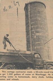 Phillip Island and District Historical Society Inc.
Newspaper Clipping, Water Cartage, 16/11/1967
Collection of newspaper clippings from scrap book 1960 - 1973Article about water carting to homesteads, dairy sheds, holiday homes and schools in November 1967.phillip island water cartage, jean jamieson