Showing 1188 items
matching hume street
-
 Hume City Civic Collection
Photograph, early 1990s
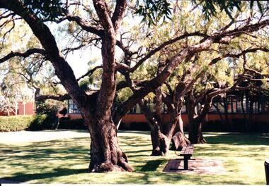
In 1963 construction of the new municipal shire offices began and the new offices were opened in October 1963. Over the years other buildings were added to the complex which included the Library and the George Evans Museum.A coloured photograph of the front view of the former Shire of Bull, Shire offices and a part of the garden area in the front with trees and a wooden seat.shire of bulla council offices, shire of bulla, george evans collection -
 Hume City Civic Collection
Photograph, early 1990s
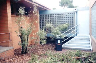
The Sunbury Library and the George Evans Museum are housed in buildings which were once extensions of the Shire of Bulla Municipal Offices. The Library was built in 1974 and the George Evans Museum formerly the Museum of History and Art was opened by the Mayor Pauline De Luca on 12 March 1987.A coloured photograph of the iron stairway and glass tiled passage way which links the library and the George Evans Museum as well as the former Shire of Bulla municipal offices. A dark green wheelie bin is at the foot of the stairs.shire of bulla council offices, george evans museum, sunbury library, shire of bulla, hume city council, george evans collection -
 Hume City Civic Collection
Photograph, early 1990s
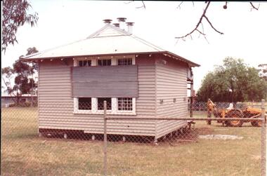
The small one roomed school is closed at the site along the Calder Highway and was relocated to the new school building in Plumpton Road at Diggers Rest. The former school building became the club rooms for the Diggers Rest Bowling Club when the new school opened in the late 1980s.A coloured photograph of the former Diggers Rest Primary School. The small one roomed weatherboard building with a corrugated iron roof has sheets of iron across the windows. The building is being prepared for relocation. A post hole digger is behind the building.diggers rest primary school, education department, diggers rest bowling club, george evans collection -
 Hume City Civic Collection
Photograph, early 1990s
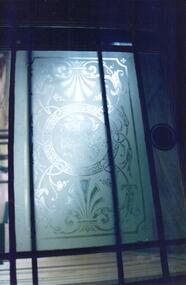
The Sunbury Asylum is now the campus for Sunbury Victoria University of Technology.A coloured photograph of a sandblasted window which is on a doorway at the former Sunbury Asylum.sunbury asylum, george evans collection -
 Hume City Civic Collection
Photograph, early 1990s
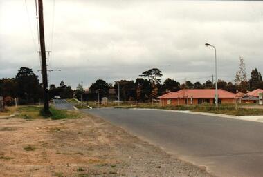
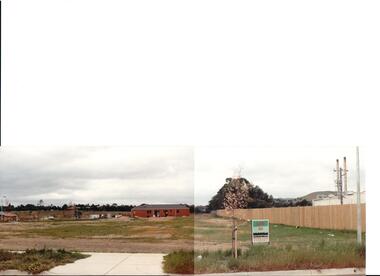
The series of 5 photographs feature different views of the Woodlands Housing Development which opened up land bounded by Gap and Anderson Roads, Cornish Street and Elizabeth Drive in the early 1990s. It was a large housing development built close to Sunbury township.A coloured photograph of one of the last housing developments which took place in the old township area. It is a photograph taken at the north end of Anderson Road looking towards Gap Road. One house has been built and there are a number of 'For Sale' signs of blocks fronting Anderson Road. Guttering and driveways have been formed on one side of the road.housing developments, anderson road, george evans collection -
 Hume City Civic Collection
Photograph, early 1990s
The series of 5 photographs feature different views of the Woodlands housing development which opened up land bounded by Gap and Anderson Roads, Cornish Street and Elizabeth Drive in the early 1990s. It was a large housing development built close to Sunbury township.A view of the northern boundary of the Woodlands housing development in Anderson Road. A paling fence divides the estate from the 'Malley' factory, now 'Storage King' which is on the corner of Cornish Street and Anderson Road. A 'For Sale' sign is in the foreground and a partly built house is in the middle distance.housing developments, anderson road, george evans collection -
 Hume City Civic Collection
Photograph, early 1990s
The series of 5 photographs feature different views of the Woodlands housing development which opened up land bounded by Gap and Anderson Roads, Cornish Street and Elizabeth Drive in the early 1990s. It was a large housing development built close to Sunbury township.A coloured photograph of a new housing development taken in Anderson Road looking west towards Elizabeth Drive and the leisure centre. Some housing construction is in the middle distance.housing developments, anderson road, george evans collection -
 Hume City Civic Collection
Photograph, September 1994
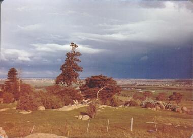
Woodlands Park complex which includes 'Cumberland' and 'Dundonald' ruins and the Gellibrand Hill Quarries was acquired by the Victorian State Government in 1978 and is managed by Parks Victoria.A view taken from Gellibrand Hill looking east towards the developing suburb of Greenvale. There are small rocky outcrops in the foreground and a clump of conifers and cypress trees in the middle. The sky is very overcast and a range of mountains can be seen across the skyline. Coloured photograph with rounded corners and matt finish.woodlands park, gellibrand hill, greene, william pomeroy, anne, george evans collection -
 Hume City Civic Collection
Photograph, September 1994
Woodlands Park complex which includes 'Cumberland' and 'Dundonald' ruins and the Gellibrand Hill Quarries was acquired by the Victorian State Government in 1978 and is managed by Parks Victoria.A view looking west towards the outer limits of the Tullamarine Airport taken from Gellibrand Hill. There is a small rocky outcrop in the middle of the photograph and trees are on the RHS of the image. Coloured photograph with rounded corners and matt finish.woodlands park, gellibrand hill, greene, william pomeroy, anne, george evans collection -
 Hume City Civic Collection
Photograph, September 1994
Woodlands Park complex which includes 'Cumberland' and 'Dundonald' ruins and the Gellibrand Hill Quarries was acquired by the Victorian State Government in 1978 and is managed by Parks Victoria.A view taken from Gellibrand Hill looking east towards the expanding suburb of Broadmeadows. Apart from a few rocky outcrops and small trees the open grassland slopes away to a small line of conifers. Coloured photograph with rounded corners and matt finish.woodlands park, gellibrand hill, greene, william pomeroy, anne, george evans collection -
 Hume City Civic Collection
Photograph, Sep-94
Woodlands Park complex which includes 'Cumberland' and 'Dundonald' ruins and the Gellibrand Hill Quarries was acquired by the Victorian State Government in 1978 and is managed by Parks Victoria.A view taken from Gellibrand Hill looking towards the recently constructed Tullamarine (Melbourne) Airport. The airport buildings are just beyond an outcrop of trees. Four rocky outcrops are spread around the foreground. Coloured photograph with rounded corners and matt finish.woodlands park, gellibrand hill, greene, william pomeroy, anne, george evans collection -
 Hume City Civic Collection
Photograph, Sep-94
Woodlands Park complex which includes 'Cumberland' and 'Dundonald' ruins and the Gellibrand Hill Quarries was acquired by the Victorian State Government in 1978 and is managed by Parks Victoria.A view taken from Gellibrand Hill looking northwest. The open grassed area in the foreground is dotted with a number of rocky outcrops with conifers and cypress trees in the background. There are a few buildings in the distance.Coloured photograph with rounded corners and matt finish.woodlands park, gellibrand hill, greene, william pomeroy, anne, george evans collection -
 Hume City Civic Collection
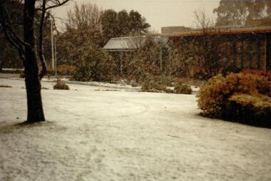
Photograph, 1/08/1986
A series of photographs were taken when heavy snow fell in Sunbury in August 1986. The snow began falling overnight and remained on the ground for 24 hours. Snow fell across the metropolitan area during that 24 hour period in a very unusual event for the area.A coloured photograph of the new main entrance to the former Shire of Bulla Council Offices and the garden immediately outside the portico area. The trees are bare and the lawn is covered with snow.snow falls, weather patterns, shire of bulla council offices, george evans collection -
 Hume City Civic Collection
Photograph, 1/08/1986
A series of photographs were taken when heavy snow fell in Sunbury in August 1986. The snow began falling overnight and remained on the ground for 24 hours. Snow fell across the metropolitan area during that 24 hour period in a very unusual event for the area.A coloured photograph of the front of the former Shire of Bulla Council Offices and front garden during a snow storm. The lawn area is covered with snow.snow falls, weather patterns, shire of bulla council offices, sunbury police station, george evans collection -
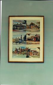 Hume City Civic Collection
Photograph, Early 1990s
The photograph is part of a set which recorded the collection of paintings and photographs displayed in the former Shire of Bulla Offices in Macedon Street.A coloured photograph of a framed set of photographs of six historic buildings in Sunbury. Included in the set are Dunblane, Priorswood, Rupertswood mansion, the former Shire Offices and the Sunbury Asylum buildings.dunblane, priorswood, council chambers, sunbury asylum, george evans collection -
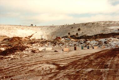 Hume City Civic Collection
Photograph, 1/08/1986
A series of photographs were taken when heavy snow fell in Sunbury in August 1986. The snow began falling overnight and remained on the ground for 24 hours. Snow fell across the metropolitan area during that 24 hour period in a very unusual event for the area.A coloured photograph of the Sunbury Municipal Tip after the snowfall.snow falls, weather patterns, winter, sunbury municipal tip, george evans collection -
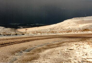 Hume City Civic Collection
Photograph, 1/08/1986
A series of photographs were taken when heavy snow fell in Sunbury in August 1986. The snow began falling overnight and remained on the ground for 24 hours. Snow fell across the metropolitan area during that 24 hour period in a very unusual event for the area.A coloured photograph taken in the early morning after snow had fallen. The surrounding countryside around Mt. Holden is snow covered.snow falls, weather patterns, winter, mt. holden (mt. lion), george evans collection -
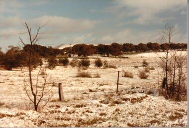 Hume City Civic Collection
Photograph, 1/08/1986
A series of photographs were taken when heavy snow fell in Sunbury in August 1986. The snow began falling overnight and remained on the ground for 24 hours. Snow fell across the metropolitan area during that 24 hour period in a very unusual event for the area.A snow scene taken in the Sunbury area.snow falls, weather patterns, winter, george evans collection -
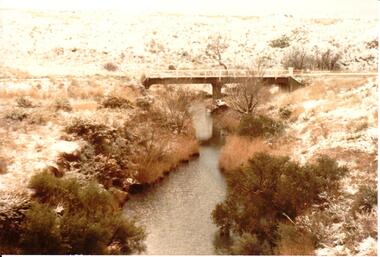 Hume City Civic Collection
Photograph, 1/08/1986
A series of photographs were taken when heavy snow fell in Sunbury in August 1986. The snow began falling overnight and remained on the ground for 24 hours. Snow fell across the metropolitan area during that 24 hour period in a very unusual event for the area.A coloured photograph of a snow scene taken near the bridge on the Konagaderra Road near Sunbury.snow falls, weather patterns, winter, konagaderra road, george evans collection -
 Hume City Civic Collection
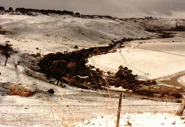
Photograph, 1/08/1986
A series of photographs were taken when heavy snow fell in Sunbury in August 1986. The snow began falling overnight and remained on the ground for 24 hours. Snow fell across the metropolitan area during that 24 hour period in a very unusual event for the area.A coloured photograph of the valley overlooking the Sunbury Sewerage farm and Eadie Hill after snow had fallen.snow falls, weather patterns, winter, sunbury sewerage farm, george evans collection -
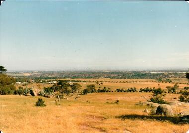
 Hume City Civic Collection
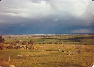
Photograph, 1980s
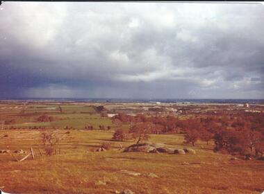
The photograph was taken above Reservoir Road on the lower slopes of Mt. Holden. It is looking south down Wilson's Lane towards some of the early Sunbury developments which grew around the Gap Road area in the early 1980s.A landscape coloured photograph with rounded corners. It is a panoramic view of Sunbury taken from the southern slopes of Mt. Holden. In the foreground there is a small cluster of trees and in the middle distance there is some evidence of housing development. Bald Hill can be seen on the skyline.wilson's lane, mt. holden, bald hill, sunbury, george evans collection -
 Hume City Civic Collection
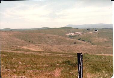
Photograph, early 1980s
The Sunbury Tip was transferred from the end of Reservoir Road as housing development spread in that area to a site on the NW side of Mt. Holden near Riddell Road in the early 1980s.A landscape coloured photograph with rounded corners. It is a panoramic view of open country NW of Sunbury near Riddell Road. There is a fence post with barbed wire hanging from it in the immediate foreground and Macedon Ranges and part of the Western Highlands can be seen across the skyline.macedon ranges, mt. macedon, camel's hump, sunbury municipal tip, george evans collection -
 Hume City Civic Collection
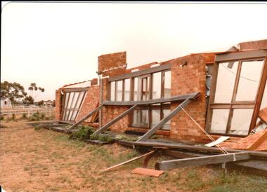
Photograph, early 1980s
The photograph was taken after a severe wind storm which occured in the Bulla-Oaklands area in the early 1980s, possibly near Christmas Eve.A coloured photograph with rounded corners. It is a panoramic view of a partly built brick veneer house which has been damaged as a result of a wind storm. Across the front are three sets of large full length windows. There is a horse training run in the background.george evans collection -
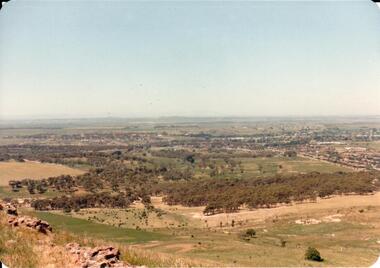
 Hume City Civic Collection
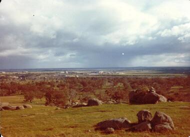
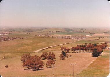
Photograph, early 1980s
The photograph shows the extent of Sunbury's development to the west of the town in the early 1980s. The settlement at this stage extended along either side of Gap Road for about 0.5 km beyond Elizabeth Drive.A coloured landscape photograph with rounded corners taken from Mt. Holden and looking towards the expanding town of Sunbury. The Melba Avenue drain which flows into Blind Creek is in the foreground. Sheoak Hill, the site of the former Sunbury Asylum is in the middle of the skyline.sunbury township, reservoir road, mt. holden, sunbury asylum, george evans collection -
 Hume City Civic Collection
Photograph, early 1980s
The Tullamarine Airport opened in 1970 and replaced Essendon Airport as Melbourne's main airport terminal. Gellibrand Hill was incorporated with Woodlands Park and became a public reserve during the 1980s.A coloured landscape photograph with rounded corners taken from Gellibrand Hill and overlooking the Tullamarine Airport which is on the RHS of the photograph. The Melbourne City skyline can be seen in the distance.gellibrand hill, tullamarine airport, melbourne skyline, george evans collection -
 Hume City Civic Collection
Photograph, early 1980s
The Headland Estate housing development began in the early 1980s. It was situated west of Sunbury and was bounded by Elizabeth Drive, Reservoir Road, Phillip Drive and Stewart's Lane.A coloured landscape photograph with rounded corners of a view of Sunbury overlooking the Headland Estate before its development. There is a rocky outcrop on the LHS of the photograph and a lightly timbered area in the middle distance. Sunbury can be seen in the distance.headland estate, mt. holden, sunbury township, george evans collection -
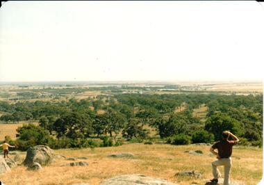 Hume City Civic Collection
Photograph, early 1980s
Gellibrand Hill along with the surrounding 3 properties: Attwood, Cumberland and Woodlands were incorporated into Gellibrand Park during the 1980s. Tullamarine became Melbourne's main air terminal in 1970 and replaced Essendon Airport.A coloured landscape photograph with rounded corners of the Tullamarine Airport taken from Gellibrand Hill. A man with his back to the camera is on the RHS and another person is running down the hill on the LHS. The area in the middle distance is lightly treed and the airport is in the distance to the right of the photograph.gellibrand hill, tullamarine airport, george evans collection -
 Hume City Civic Collection
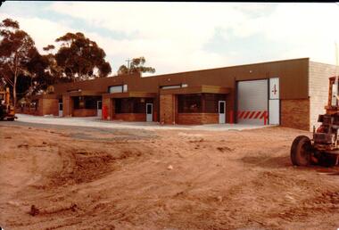
Photograph, 1/12/1982
The railway land between Horne Street and the railway line was developed for commercial and industrial purposes during the late 1970s and early 1980s. The former Shire of Bulla developed much of this area and leased the space to private companies.A coloured photograph with rounded corners of 4 brick factory units. There is a large digger on the RHS. The area in front of the units has been paved but the remaining area is unsealed.factories, industrial estates, shire of bulla, george evans collection -
 Hume City Civic Collection
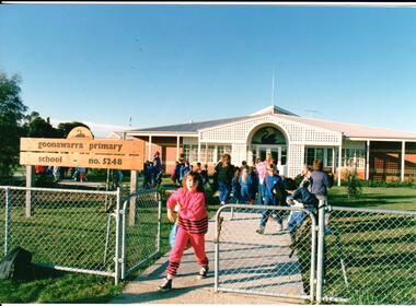
Photograph, early 1980s
Goonawarra Primary School was opened in the early 1980s to accommodate children who were living in the Goonawarra Housing Estate. Prior to development this area was known as Goonawarra Farm and John McMahon grazed his dairy cattle on the land.A coloured photograph of the Goonawarra Primary School and main gate with school children leaving the grounds. A girl dressed in a pink tracksuit is at the gate.state education, schools, goonawarra primary school, goonawarra housing estate, goonawarra farm, ministry of education, george evans collection -
 Hume City Civic Collection
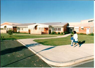
Photograph, early 1980s
Goonawarra Primary School was opened in the early 1980s to accommodate children who were living in the Goonawarra Housing Estate. Prior to development this area was known as Goonawarra Farm and John McMahon grazed his dairy cattle on the land.A coloured photograph of the recently completed Goonawarra Primary School. A lady and little boy are walking along the footpath in front of the building. There is an expanse of lawn between the path and the building.state education, schools, goonawarra primary school, goonawarra housing estate, goonawarra farm, ministry of education, george evans collection